About GeoNames
The GeoNames geographical database is available for download free of charge under a creative commons attribution license. It contains over 25 million geographical names and consists of over 12 million unique features whereof 4.8 million populated places and 16 million alternate names. All features are categorized into one out of nine feature classes and further subcategorized into one out of 645 feature codes. (more statistics ...).The data is accessible free of charge through a number of webservices and a daily database export.
GeoNames is integrating geographical data such as names of places in various languages, elevation, population and others from various sources. All lat/long coordinates are in WGS84 (World Geodetic System 1984). Users may manually edit, correct and add new names using a user friendly wiki interface.
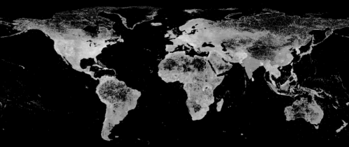
Figure : GeoNames Feature Density Map
Support GeoNames
We accept donations :

|
Press Coverage and Quotations
- Programmableweb 23 May 2012 - GeoNames most popular API
- TechCrunch 26 May 2007
- Linuxworld Dec 2006 put geonames.org on a list of "Ten Web 2.0 APIs you can really use", just behind googlmaps : The GeoNames database is one of the best available, based on multiple data sets, and it uses a liberal Creative Commons Attribution license for its data output. It's also quick and responsive.
- Sir Tim Berners-Lee : This is a tremendous set of data you have there.
- Nature 13. Feb 2006 : ... we hope that database providers will support initiatives, such as the GeoNames Forum.
- google.dirson.com 25. Feb 2006 : ... una de las mejores herramientas que hemos visto uniendo 'Google Maps' y Ajax.
- barrapunto.com 3. March 2006 : ... GeoNames los ha organizado en una base de datos brillante y abierta y, además corregible
Most important sources
- nga : National Geospatial-Intelligence Agency's (NGA) and the U.S. Board on Geographic Names
- gnis : U.S. Geological Survey Geographic Names Information System (names in US).
- Ordnance Survey OpenData
gazetteer: Contains Ordnance Survey data Crown copyright and database right 2010.
gazetteer: Contains public sector information licensed under the Open Government Licence v1.0.
postal codes: Contains Royal Mail data Royal Mail copyright and database right 2010. - GeoBase - Canadian Geographical Names (names in CA)
- gtopo30 (elevation)
Features for online users
- search for names with our fulltextsearch (table based or displayed on map)
- browse capitals, highest mountains and largest cities on map
- browse names on map and show/hide feature classes and codes
- bookmark maps
- send maps via email
- export names as character separated values (csv) file or as png image
- edit names (wiki)
- add new names to the database (for registered users)
- geotagging of names (for registered users)
Wiki
In order to allow users to improve and correct data browser based update possibilities are available. The update rights of the anonymous (not logged in) user are restricted and records may be locked for update depending on the userlevel.(user manual)The most recent changes are available here.
GeoNames Users
- Apple SnowLeopard, Ubuntu
- Bing Maps, Microsoft Popfly, Multimap
- Adidas and Nike
- ESRI, DigitalGlobe and Spot Image
- New York Times, BBC, Norwegian Broadcasting Corp, km42 Spiegel Online
- US Geological Survey
- slide.com
- Nokia
GeoNames Messageboard, Mailinglist and Blog
GeoNames Webservice Clients and Plugins
Client libraries developed by the community are available in a number of programming languages such as Java, Ruby, Python, Perl and even Lisp.GeoNames was founded by Marc Wick. You can reach him at marc@geonames.org
GeoNames is a project of Unxos GmbH, Tutilostrasse 17d, 9011 St. Gallen, Switzerland.

