| 135 records found in wikipedia |
| 1 | | Maritsa 
FeatureType : null
Lat/Lng : 40.7306 / 26.035
| The Maritsa, Meriç or Evros (Marica; , Hébros; , Évros; ; Romanized Thracian: Evgos or Ebros;) is, with a length of (of which in Bulgaria), National Statistical Institute (Bulgaria), p. 17, the longest river that runs solely in the interior of the Balkans. Its drainage area is about , of which 66 (...) |
| 2 | 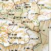
| Svilengrad
FeatureType : city
Elevation : 57
Lat/Lng : 41.7654 / 26.2033
| Svilengrad is a town in Haskovo Province, south-central Bulgaria, situated at the border of Turkey and Greece. It is the administrative centre of the homonymous Svilengrad Municipality. As of December 2009, the town has a population of 18,132 inhabitants (...) |
| 3 | 
| Plovdiv
FeatureType : city
Elevation : 183
Lat/Lng : 42.1468 / 24.7509
| Plovdiv is the second-largest city in Bulgaria, with a city population of 345,213 and 675,000 in the greater metropolitan area. It is an important economic, transport, cultural, and educational center. There is evidence of habitation in Plovdiv dating back to the 6th millennium BCE, when the first (...) |
| 4 | 
| Pazardzhik
FeatureType : city
Elevation : 211
Lat/Lng : 42.1875 / 24.3292
| Pazardzhik is a city situated along the banks of the Maritsa river, Southern Bulgaria. It is the capital of Pazardzhik Province and centre for the homonymous Pazardzhik Municipality. (...) |
| 5 | 
| Rila
FeatureType : mountain
Elevation : 2324
Lat/Lng : 42.1333 / 23.55
| Rila is a mountain range in southwestern Bulgaria and the highest mountain range of Bulgaria and the Balkans, with its highest peak being Musala at 2,925 m. The massif is also the sixth highest mountain in Europe (when each mountain is represented by its highest peak only), coming after the (...) |
| 6 | | Battle of Maritsa
FeatureType : null
Elevation : 64
Lat/Lng : 41.7167 / 26.2167
| The Battle of Maritsa, or Battle of Chernomen (in tr. Second Battle of Maritsa) took place at the Maritsa River near the village of Chernomen (today Ormenio in Greece) on 26 September 1371 between the forces of Ottoman commanders Lala Shahin Pasha and Evrenos and Serbian commanders King Vukašin (...) |
| 7 | | Arda (Maritsa)
FeatureType : null
Elevation : 30
Lat/Lng : 41.6608 / 26.495
| The Arda is a long river in Bulgaria and Greece. It is a tributary of the Maritsa . Its source lies in the Bulgarian Rhodope Mountains near the village Arda, part of the municipality of Smolyan. It flows eastward past Rudozem, Kardzhali and Ivaylovgrad and enters Greece in the northern part of the (...) |
| 8 | 
| Geography of Bulgaria
FeatureType : country
Elevation : 441
Lat/Lng : 43.0 / 25.0
| Bulgaria is a country situated in south-eastern Europe, bordering Romania to the north, Serbia and the Republic of Macedonia to the west, Greece and Turkey to the south, and the Black Sea to the east. The northern border with Romania follows the river Danube until the city of Silistra (...) |
| 9 | | Maritsa Municipality
FeatureType : adm2nd
Elevation : 171
Lat/Lng : 42.2172 / 24.7855
| Maritsa Municipality (obshtina) is located in the Plovdiv Province, southern Bulgaria on the northern bank of the Maritsa River. It has 30,676 inhabitants and consists only of villages. The municipality has thriving industry with around €400 000 000 invested in the recent years (...) |
| 10 | 
| Rhodes
FeatureType : isle
Elevation : 117
Lat/Lng : 36.1836 / 27.9639
| Rhodes (Ródos) is the largest of the Dodecanese islands of Greece in terms of land area and also the island group's historical capital. Administratively the island forms a separate municipality within the Rhodes regional unit, which is part of the South Aegean administrative region (...) |
| 11 | 
| Bulgaria
FeatureType : country
Elevation : 414
Lat/Lng : 42.65 / 25.4
| Bulgaria (; , tr. '), officially the Republic of Bulgaria (tr. '), is a country in southeastern Europe. It is bordered by Romania to the north, Serbia and Macedonia to the west, Greece and Turkey to the south, and the Black Sea to the east (...) |
| 12 | 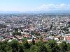
| Serres
FeatureType : city
Elevation : 49
Lat/Lng : 41.0856 / 23.5497
| Sérres is a city in Macedonia, Greece, capital of the Serres regional unit and second largest city in the region of Central Macedonia, after Thessaloniki. Serres is one of the administrative and economic centers of Northern Greece (...) |
| 13 | 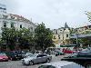
| Burgas
FeatureType : null
Elevation : 12
Lat/Lng : 42.4953 / 27.4717
| Burgas , sometimes transliterated as Bourgas, is the second largest city on the Bulgarian Black Sea Coast and the fourth-largest in Bulgaria after Sofia, Plovdiv, and Varna, with a population of 202,694 inhabitants, while 277,922 live in its urban area (...) |
| 14 | 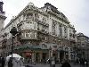
| Belgrade
FeatureType : null
Elevation : 93
Lat/Lng : 44.8206 / 20.4622
| Belgrade (; / Београд, meaning "white city", ;) is the capital and largest city of Serbia. It is located at the confluence of the Sava and Danube rivers, where the Pannonian Plain meets the Balkans. The urban area of the City of Belgrade has a population of 1.23 million, while nearly 1 (...) |
| 15 | | Haskovo Province
FeatureType : null
Elevation : 179
Lat/Lng : 41.8333 / 25.9167
| Haskovo Province (- Oblast Haskovo, former name Haskovo okrug) is a province in southern Bulgaria, neighbouring Greece and Turkey to the southeast, comprising parts of the Thracian valley along the river Maritsa. It is named after its administrative and industrial centre - the city of Haskovo (...) |
| 16 | 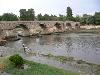
| Skopje
FeatureType : city
Elevation : 243
Lat/Lng : 41.9966 / 21.4324
| Skopje is the capital and largest city of the Republic of Macedonia. It is the country's political, cultural, economic, and academic center. It was known in the Greek and Roman period under the name Scupi. The territory of Skopje has been inhabited since at least 4000 BC; remains of Neolithic (...) |
| 17 | 
| Harmanli
FeatureType : city
Elevation : 74
Lat/Lng : 41.9333 / 25.9
| Harmanli is a town in Haskovo Province, South-central Bulgaria. It is the administrative centre of the eponymous Harmanli Municipality. As of December 2009, the town has a population of 18,557 inhabitants. Harmanli was founded 1510 along the road connecting Central Europe and Anatolia. (...) |
| 18 | 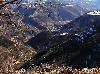
| Iskar (river)
FeatureType : waterbody
Elevation : 2548
Lat/Lng : 42.1942 / 23.3303
| The Iskar is a right tributary of the Danube. With a length of 352 km it is the longest river that runs entirely within Bulgaria., National Statistical Institute (Bulgaria), p. 17 Originating as three forks in Balkan's highest mountain range Rila, it flows in northern direction until its confluence (...) |
| 19 | 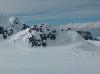
| Maritsa Peak
FeatureType : null
Lat/Lng : -62.6172 / -60.1392
| Maritsa Peak (Vrah Maritsa \'vr&h ma-'ri-tsa\) rises to 560 m in eastern Bowles Ridge on Livingston Island in the South Shetland Islands, Antarctica. It has precipitous rocky south slopes, and is situated on the west side of Pirdop Gate, surmounting Huron Glacier to the south and Struma Glacier to (...) |
| 20 | 
| Kazanlak
FeatureType : null
Elevation : 366
Lat/Lng : 42.6167 / 25.4
| Kazanlak (Kazanlǎk, Thracian and Greek Σευθόπολις (Seuthopolis) is a Bulgarian town in Stara Zagora Province, located in the middle of the plain of the same name, at the foot of the Balkan mountain range, at the eastern end of the Rose Valley (...) |
 by
by