| 201 records found in wikipedia | |||
| 1 | 
| Miami International Airport  FeatureType : airport Elevation : 10 Lat/Lng : 25.7933 / -80.2906 | Miami International Airport , also known as MIA and historically as Wilcox Field, is the primary airport serving the Miami area. The airport is in an unincorporated area in Miami-Dade County, Florida, northwest of Downtown Miami, in metropolitan Miami,, effective October 25, 2007 between the cities (...) |
| 2 | 
| Dayton, Ohio FeatureType : null Elevation : 237 Lat/Lng : 39.7594 / -84.1917 | Dayton is the sixth-largest city in the state of Ohio and the county seat of Montgomery County. A small part of the city extends into Greene County. The 2017 U.S. census estimate put the city population at 140,371, while Greater Dayton was estimated to be at 803,416 residents (...) |
| 3 | 
| Duke University FeatureType : edu Elevation : 123 Lat/Lng : 36.0011 / -78.9389 | Duke University is a private, non-profit, research university located in Durham, North Carolina. Founded by Methodists and Quakers in the present-day town of Trinity in 1838, the school moved to Durham in 1892. In 1924, tobacco and electric power industrialist James Buchanan Duke established The (...) |
| 4 | 
| Portland, Maine FeatureType : null Elevation : -1 Lat/Lng : 43.6332 / -70.1856 | Portland is the most populous city in the U.S. state of Maine, with a population of 67,067 as of 2017. The Greater Portland metropolitan area is home to over half a million people, more than one-third of Maine's total population, making it the most populous metro in northern New England (an area (...) |
| 5 | 
| Richmond, Virginia FeatureType : city Elevation : 55 Lat/Lng : 37.5489 / -77.4474 | Richmond is the capital of the Commonwealth of Virginia in the United States. It is the center of the Richmond Metropolitan Statistical Area (MSA) and the Greater Richmond Region. Richmond was incorporated in 1742 and has been an independent city since 1871 (...) |
| 6 | 
| Kansas City, Missouri FeatureType : null Elevation : 244 Lat/Lng : 39.1097 / -94.5886 | Kansas City is the largest city in the U.S. state of Missouri. According to the U.S. Census Bureau, the city had an estimated population of 488,943 in 2017, making it the 37th most-populous city in the United States (...) |
| 7 | 
| Hanford Site FeatureType : landmark Elevation : 143 Lat/Lng : 46.6475 / -119.5986 | The Hanford Site is a decommissioned nuclear production complex operated by the United States federal government on the Columbia River in the U.S. state of Washington. The site has been known by many names, including Hanford Project, Hanford Works, Hanford Engineer Works and Hanford Nuclear (...) |
| 8 | 
| Butte, Montana FeatureType : city Elevation : 1664 Lat/Lng : 45.9989 / -112.5242 | Butte is a town in, and the county seat of Silver Bow County, Montana, United States. In 1977, the city and county governments consolidated to form the sole entity of Butte-Silver Bow. The city covers , and, according to the 2010 census, has a population of approximately 36,400, making it Montana's (...) |
| 9 | 
| Richland, Washington FeatureType : null Elevation : 109 Lat/Lng : 46.2797 / -119.2814 | Richland is a city in Benton County in the southeastern part of the State of Washington, at the confluence of the Yakima and the Columbia Rivers. As of the 2010 census, the city's population was 48,058. July 1, 2017, estimates from the Census Bureau put the city's population at 56,243 (...) |
| 10 | 
| Michigan State University FeatureType : edu Elevation : 260 Lat/Lng : 42.7234 / -84.4814 | Michigan State University (MSU) is a public research university in East Lansing, Michigan, United States. MSU was founded in 1855 and served as a model for land-grant universities later created under the Morrill Act of 1862 (...) |
| 11 | 
| Rose Bowl (stadium) FeatureType : landmark Elevation : 259 Lat/Lng : 34.161 / -118.168 | The Rose Bowl, also known as Spieker Field at the Rose Bowl, is an American outdoor athletic stadium, located in Pasadena, California, a northeast suburb of Los Angeles. Opened in October 1922, the stadium is recognized as a National Historic Landmark and a California Historic Civil Engineering (...) |
| 12 | 
| University of Southern California FeatureType : edu Elevation : 70 Lat/Lng : 34.0205 / -118.2856 | The University of Southern California (USC or SC) is an American private research university in Los Angeles, California. Founded in 1880, it is the oldest private research university in California. . Usc.edu. Retrieved on 2015-11-28 (...) |
| 13 | 
| Nevis FeatureType : isle Elevation : 725 Lat/Lng : 17.1528 / -62.5892 | Nevis is a small island in the Caribbean Sea that forms part of the inner arc of the Leeward Islands chain of the West Indies. Nevis and the neighbouring island of Saint Kitts constitute one country: the Federation of Saint Kitts and Nevis (...) |
| 14 | 
| Duluth, Minnesota FeatureType : null Elevation : 193 Lat/Lng : 46.7869 / -92.0982 | Duluth is a major port city in the U.S. state of Minnesota and the county seat of Saint Louis County. Duluth has a population of 86,293 and is the 4th largest city in Minnesota. It is the second-largest city on Lake Superior after Thunder Bay, Ontario, Canada (...) |
| 15 | 
| Hackensack, New Jersey FeatureType : city Elevation : 8 Lat/Lng : 40.8894 / -74.0457 | Hackensack is a city in Bergen County in New Jersey, United States, and serves as its county seat., New Jersey Department of State. Accessed July 10, 2017. The area was officially named New Barbadoes Township until 1921, but it was informally known as Hackensack since at least the 18th century (...) |
| 16 | Marion County, Oregon FeatureType : adm2nd Elevation : 713 Lat/Lng : 44.91 / -122.58 | Marion County is a county located in the U.S. state of Oregon. The population was 315,335 at the 2010 census, making it the fifth-most populous county in Oregon. The county seat is Salem, the state capital. The county was originally named the Champooick District, after Champoeg (earlier (...) | |
| 17 | 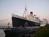
| RMS Queen Mary FeatureType : landmark Elevation : 13 Lat/Lng : 33.7531 / -118.1898 | The RMS Queen Mary is a retired British ocean liner that sailed primarily on the North Atlantic Ocean from 1936 to 1967 for the Cunard Line – known as Cunard-White Star Line when the vessel entered service. She was the flagship of the Cunard and White Star Lines, built by John Brown & Company in (...) |
| 18 | 
| West Orange, New Jersey FeatureType : city Elevation : 174 Lat/Lng : 40.7858 / -74.2651 | West Orange is a suburbanHaddon, Heather. , The Wall Street Journal, December 19, 2014. Accessed March 28, 2016. "Mr. Bryne hails from the Irish-American Democratic establishment that was once a driving force of New Jersey politics (...) |
| 19 | 
| Roslyn, Washington FeatureType : city Elevation : 712 Lat/Lng : 47.2251 / -121.003 | Roslyn is a city in Kittitas County, Washington, United States. The population was 893 at the 2010 census. Roslyn in located in the Cascade Mountains, about 80 miles east of Seattle. The town was founded in 1886 as a coal mining company town (...) |
| 20 | St. Helens, Oregon FeatureType : city Elevation : 36 Lat/Lng : 45.8594 / -122.8169 | St. Helens is the county seat of Columbia County, Oregon. It was founded by Captain Henry Montgomery Knighton, a native of New England, in 1845, as "Plymouth". The name was changed to St. Helens in the latter part of 1850 for its view of Mount St. Helens, roughly away in Washington (...) | |
| 21 | Nike, Inc. FeatureType : landmark Elevation : 56 Lat/Lng : 45.5093 / -122.8299 | Nike, Inc. is an American multinational corporation that is engaged in the design, development, manufacturing, and worldwide marketing and sales of footwear, apparel, equipment, accessories, and services. The company is headquartered near Beaverton, Oregon, in the Portland metropolitan area (...) | |
| 22 | United States Census Bureau FeatureType : landmark Elevation : 86 Lat/Lng : 38.8466 / -76.9271 | The United States Census Bureau (USCB; officially the Bureau of the Census, as defined in Title) is a principal agency of the U.S. Federal Statistical System, responsible for producing data about the American people and economy. The Census Bureau is part of the U.S (...) | |
| 23 | United States presidential election, 2016 FeatureType : null Elevation : 25 Lat/Lng : 40.7122 / -73.5995 | The United States Presidential Election of 2016 was the 58th quadrennial American presidential election, held on Tuesday, November 8, 2016. The Republican ticket of businessman Donald Trump and Indiana Governor Mike Pence defeated the Democratic ticket of former Secretary of State Hillary Clinton (...) | |
| 24 | United States presidential election, 2008 FeatureType : null Elevation : 1636 Lat/Lng : 39.7392 / -104.9847 | The United States presidential election of 2008 was the 56th quadrennial presidential election. It was held on Tuesday, November 4, 2008. The Democratic ticket of Barack Obama, a Senator from Illinois, and Joe Biden, a long-time Senator from Delaware, defeated the Republican ticket of Senator John (...) | |
| 25 | Solar eclipse of August 21, 2017 FeatureType : null Elevation : 161 Lat/Lng : 36.975 / -87.655 | The solar eclipse of August 21, 2017, dubbed "The Great American Eclipse" by the media,See, e.g., ; ; ; ; . was a total solar eclipse visible within a band that spanned the entire contiguous United States, passing from the Pacific to the Atlantic coasts (...) | |
| 26 | North America FeatureType : null Elevation : 453 Lat/Lng : 48.1667 / -100.1667 | North America is a continent entirely within the Northern Hemisphere and almost all within the Western Hemisphere; it is also considered by some to be a northern subcontinent of the Americas. It is bordered to the north by the Arctic Ocean, to the east by the Atlantic Ocean, to the west and south by (...) | |
| 27 | NCAA Division I Men's Basketball Tournament FeatureType : null Elevation : 128 Lat/Lng : 34.0722 / -118.4441 | The NCAA Division I Men's Basketball Tournament, also known and branded as NCAA March Madness, is a single-elimination tournament played each spring in the United States, currently featuring 68 college basketball teams from the Division I level of the National Collegiate Athletic Association (NCAA), (...) | |
| 28 | Oswego, New York FeatureType : null Elevation : 93 Lat/Lng : 43.4586 / -76.5036 | Oswego is a city in Oswego County, New York, United States. The population was 18,142 at the 2010 census. Oswego is located on Lake Ontario in north-central New York and promotes itself as "The Port City of Central New York". It is the county seat of Oswego County (...) | |
| 29 | Nevada FeatureType : adm1st Elevation : 1767 Lat/Lng : 39.0 / -117.0 | Nevada is a state in the Western United States.Also sometimes placed in the Mountain West and Southwestern United States. It borders Oregon to the northwest, Idaho to the northeast, California to the west, Arizona to the southeast and Utah to the east (...) | |
| 30 | Geography of the United States FeatureType : null Elevation : 414 Lat/Lng : 38.0 / -97.0 | The term "United States", when used in the geographical sense, is the contiguous United States, the state of Alaska, the island state of Hawaii, the five insular territories of Puerto Rico, Northern Mariana Islands, U.S. Virgin Islands, Guam, and American Samoa, and minor outlying possessions.U.S (...) | |
| 31 | Carter County, Missouri FeatureType : adm2nd Elevation : 163 Lat/Lng : 36.94 / -90.97 | Carter County is a county in the U.S. state of Missouri. As of the 2010 census, the population was 6,265. The county seat is Van Buren. The county was officially organized on March 10, 1859, and is named after Zimri A. Carter, a pioneer settler who came to Missouri from South Carolina in 1812 (...) | |
| 32 | Chesnee, South Carolina FeatureType : city Elevation : 273 Lat/Lng : 35.1483 / -81.8619 | Chesnee is a city in Spartanburg and Cherokee counties, in the U.S. state of South Carolina. The population was 868 as of the 2010 census., making it the smallest city of South Carolina in that census, although it is around nineteen times the size of South Carolina's smallest municipality, the town (...) | |
| 33 | Sumpter, Oregon FeatureType : city Elevation : 1365 Lat/Lng : 44.7461 / -118.1992 | Sumpter is a city in Baker County, Oregon, United States. The population was 204 at the 2010 census. Sumpter is named after Fort Sumter by its founders. The name was inspired by a rock as smooth and round as a cannonball, which reminded a local resident of the American Civil War and Fort Sumter. (...) | |
| 34 | Rajneesh FeatureType : landmark Elevation : 554 Lat/Lng : 18.5375 / 73.8869 | Rajneesh (born Chandra Mohan Jain, 11 December 1931 – 19 January 1990), also known as Acharya Rajneesh, Bhagwan Shree Rajneesh, and latterly as Osho , was an Indian godman and leader of the Rajneesh movement. During his lifetime he was viewed as a controversial new religious movement leader and (...) | |
| 35 | Colorado FeatureType : adm1st Elevation : 2639 Lat/Lng : 39.0 / -105.0833 | Colorado (other variants) is a state of the Western United States encompassing most of the southern Rocky Mountains as well as the northeastern portion of the Colorado Plateau and the western edge of the Great Plains. It is the 8th largest geographically and 21st most populous U.S. state (...) | |
| 36 | Pamlico Sound FeatureType : null Lat/Lng : 35.3128 / -75.9372 | Pamlico Sound in North Carolina in the US is the largest lagoon along the North American East Coast, extending long and 15 to 20 miles (24 to 48 km) wide. It is part of a large, interconnected network of lagoon estuaries that includes Albemarle Sound, Currituck Sound, Croatan Sound, Pamlico Sound, (...) | |
| 37 | BP FeatureType : null Lat/Lng : 28.7539 / -88.3147 | BP plc (formerly The British Petroleum Company plc and BP Amoco plc) is a British multinational oil and gas company headquartered in London, England. It is one of the world's seven oil and gas "supermajors", whose performance in 2012 made it the world's sixth-largest oil and gas company, the (...) | |
| 38 | Lawrence, Kansas FeatureType : city Elevation : 267 Lat/Lng : 38.9717 / -95.2353 | Lawrence is the county seat of Douglas County and sixth largest city in Kansas. It is located in the northeastern sector of the state, next to Interstate 70, between the Kansas and Wakarusa Rivers. As of the 2010 census, the city's population was 87,643 (...) | |
| 39 | Auburn University FeatureType : edu Elevation : 212 Lat/Lng : 32.6034 / -85.4861 | Auburn University (AU or Auburn) is a land-grant and public research university in Auburn, Alabama, United States. With more than 23,000 undergraduate students and a total enrollment of more than 30,000 with 1,260 faculty members, Auburn is the second largest university in Alabama.http://ocm.auburn (...) | |
| 40 | Walmart FeatureType : null Elevation : 398 Lat/Lng : 36.3656 / -94.2175 | Walmart Inc. (formerly Wal-Mart Stores, Inc.) is an American multinational retail corporation that operates a chain of hypermarkets, discount department stores, and grocery stores. Headquartered in Bentonville, Arkansas, the company was founded by Sam Walton in 1962 and incorporated on October 31, (...) | |
| 41 | United States Environmental Protection Agency FeatureType : null Elevation : 8 Lat/Lng : 38.8939 / -77.0289 | The Environmental Protection Agency is an independent agency of the United States federal government for environmental protection. President Richard Nixon proposed the establishment of EPA on July 9, 1970 and it began operation on December 2, 1970, after Nixon signed an executive order (...) | |
| 42 | Southern Poverty Law Center FeatureType : null Elevation : 84 Lat/Lng : 32.3767 / -86.3033 | The Southern Poverty Law Center (SPLC) is an American nonprofit legal advocacy organization specializing in civil rights and public interest litigation. Based in Montgomery, Alabama, it is noted for its successful legal cases against white supremacist groups, its classification of hate groups and (...) | |
| 43 | Geocaching FeatureType : landmark Elevation : 202 Lat/Lng : 45.291 / -122.4133 | Geocaching is an outdoor recreational activity, in which participants use a Global Positioning System (GPS) receiver or mobile device and other navigational techniques to hide and seek containers, called "geocaches" or "caches", at specific locations marked by coordinates all over the world (...) | |
| 44 | Catlow Valley FeatureType : null Elevation : 1390 Lat/Lng : 42.5635 / -119.0583 | The Catlow Valley is a basin in Harney County, Oregon, United States. It is a remote valley at the northwestern corner of North America's Basin and Range Province. The valley is named after a pioneer rancher, John Catlow (...) | |
| 45 | Stony Brook University FeatureType : edu Elevation : 41 Lat/Lng : 40.9142 / -73.1162 | The State University of New York at Stony Brook (SUNY Stony Brook; SUNY SB), commonly known as Stony Brook University (SBU) or Stony Brook, is a public sea-grant and space-grant research university in Stony Brook, New York, east of New York City on Long Island, which is part of the State University (...) | |
| 46 | Marshall Field's FeatureType : landmark Elevation : 196 Lat/Lng : 41.8839 / -87.6272 | Marshall Field's (officially Marshall Field & Company) was a department store in Chicago, Illinois, that grew to become a chain before being acquired by Federated Department Stores in 2005. The former flagship Marshall Field and Company Building location on State Street in the Loop of downtown (...) | |
| 47 | Holmes County, Mississippi FeatureType : adm2nd Elevation : 78 Lat/Lng : 33.1333 / -90.0833 | Holmes County is a county in the U.S. state of Mississippi; its western border is formed by the Yazoo River and the eastern border by the Big Black River. The western part of the county is within the Yazoo-Mississippi Delta. As of the 2010 census, the population was 19,198 (...) | |
| 48 | 2017 NCAA Division I Men's Basketball Tournament FeatureType : null Elevation : 245 Lat/Lng : 39.7404 / -84.1792 | The 2017 NCAA Division I Men's Basketball Tournament involved 68 teams playing in a single-elimination tournament to determine the men's National Collegiate Athletic Association (NCAA) Division I college basketball national champion for the 2016–17 season (...) | |
| 49 | Outer Banks FeatureType : null Lat/Lng : 35.3737 / -75.4953 | The Outer Banks is a string of barrier islands and spits off the coast of North Carolina and southeastern Virginia, on the east coast of the United States. They cover most of the North Carolina coastline, separating Currituck Sound, Albemarle Sound, and Pamlico Sound from the Atlantic Ocean (...) | |
| 50 | Little League World Series FeatureType : null Elevation : 187 Lat/Lng : 41.23 / -76.98 | The Little League Baseball World Series is an annual baseball tournament in the eastern United States for children aged 10 to 12 years old. Originally called the National Little League Tournament, it was later renamed for the World Series in Major League Baseball (...) | |
| 51 | Gold rush FeatureType : null Elevation : 278 Lat/Lng : -19.6167 / -42.5 | A gold rush is a new discovery of gold—sometimes accompanied by other precious metals and rare earth minerals—that brings an onrush of miners seeking their fortune. Major gold rushes took place in the 19th century in Australia, New Zealand, Brazil, Canada, South Africa and the United States, while (...) | |
| 52 | CenturyLink Field FeatureType : landmark Elevation : 23 Lat/Lng : 47.5952 / -122.3316 | CenturyLink Field is a multi-purpose stadium located in Seattle, Washington, United States. It is the home field for the Seattle Seahawks of the National Football League (NFL) and Seattle Sounders FC of Major League Soccer (MLS) (...) | |
| 53 | University of Arizona FeatureType : edu Elevation : 751 Lat/Lng : 32.2317 / -110.9519 | The University of Arizona (also referred to as Arizona, U of A, or UA) is a public research university in Tucson, Arizona. Founded in 1885, the UA was the first university in the Arizona Territory. , the university enrolls 44,831 students in 19 separate colleges/schools, including the University of (...) | |
| 54 | Traffic light FeatureType : landmark Elevation : 1905 Lat/Lng : 43.4795 / -110.7627 | Traffic lights, also known as traffic signals, traffic lamps, traffic semaphore, signal lights, stop lights, robots (in South Africa and most of Africa), and traffic control signals (in technical parlance), The Origins and Globalization of Traffic Control Signals — Retrieved 8 December 2013 are (...) | |
| 55 | 
| Chimney Rock National Historic Site FeatureType : landmark Elevation : 1215 Lat/Lng : 41.7039 / -103.3481 | Chimney Rock is a prominent geological rock formation in Morrill County in western Nebraska. Rising nearly 300 feet (91 m) above the surrounding North Platte River valley, the peak of Chimney Rock is above sea level (...) |
| 56 | 2012 NCAA Division I Men's Basketball Tournament FeatureType : null Elevation : 226 Lat/Lng : 39.7356 / -84.2 | The 2012 NCAA Division I Men's Basketball Tournament was a single-elimination tournament involving 68 schools playing to determine the national champion of men's NCAA Division I college basketball. It began on March 13, 2012, and concluded with the championship game on April 2 at the Mercedes-Benz (...) | |
| 57 | Tampa Bay Buccaneers FeatureType : null Elevation : 4 Lat/Lng : 27.8769 / -82.5906 | The Tampa Bay Buccaneers are a professional American football franchise based in Tampa, Florida. The Buccaneers currently compete in the National Football League (NFL) as a member team of the National Football Conference (NFC) South division (...) | |
| 58 | Rodanthe, North Carolina FeatureType : null Elevation : 5 Lat/Lng : 35.5933 / -75.4678 | Rodanthe is an unincorporated community and census-designated place (CDP) located in Dare County, North Carolina, United States, on Hatteras Island, part of North Carolina's Outer Banks. As of the 2010 census it had a population of 261 (...) | |
| 59 | Facebook FeatureType : landmark Elevation : 7 Lat/Lng : 37.4848 / -122.1484 | Facebook, Inc. is an American online social media and social networking service company based in Menlo Park, California. Its website was launched on February 4, 2004, by Mark Zuckerberg, along with fellow Harvard College students and roommates Eduardo Saverin, Andrew McCollum, Dustin Moskovitz and (...) | |
| 60 | Supreme Court of the United States FeatureType : landmark Elevation : 34 Lat/Lng : 38.8907 / -77.0043 | The Supreme Court of the United States (sometimes colloquially referred to by the acronym SCOTUS) is the highest court in the federal judiciary of the United States. Established pursuant to Article III of the U.S (...) | |
| 61 | American Legion FeatureType : null Elevation : 222 Lat/Lng : 39.777 / -86.1562 | The American Legion is a U.S. war veterans organization headquartered in Indianapolis, Indiana. It is made up of state, U.S. territory, and overseas departments, and these are in turn made up of local posts. The legislative body of The American Legion is a national convention, held annually (...) | |
| 62 | Sussex County, New Jersey FeatureType : adm2nd Elevation : 169 Lat/Lng : 41.14 / -74.69 | Sussex County is the northernmost county in the State of New Jersey. Its county seat is Newton., New Jersey Department of State. Accessed July 10, 2017. It is part of the New York City Metropolitan Area. As of the 2017 Census estimate, the county's population was 141,682, making it the 17th-most (...) | |
| 63 | Presbyterian College FeatureType : edu Elevation : 199 Lat/Lng : 34.4644 / -81.87 | Presbyterian College, commonly known as PC, is a four-year, private liberal arts college located in Clinton, South Carolina and affiliated with the Presbyterian Church USA. Presbyterian's undergraduate and graduate programs emphasize small class sizes, a congenial atmosphere between professors and (...) | |
| 64 | Charleston FeatureType : null Elevation : 165 Lat/Lng : 35.297 / -94.0363 | Charleston most commonly refers to: * Charleston, South Carolina, the largest US city named Charleston * Charleston, West Virginia, the US state's capital and largest city * Charleston (dance) Charleston may also refer to: (...) | |
| 65 | Lacey, Washington FeatureType : city Elevation : 57 Lat/Lng : 47.0264 / -122.8072 | Lacey is a city in Thurston County, Washington, United States. Established as a suburb of Olympia, its population was 42,393 at the 2010 census out of a county population of 252,264. (...) | |
| 66 | Swing bridge FeatureType : landmark Elevation : 1 Lat/Lng : 53.5341 / 8.5847 | A swing bridge is a movable bridge that has as its primary structural support a vertical locating pin and support ring, usually at or near to its center of gravity, about which the turning span can then pivot horizontally as shown in the animated illustration to the right (...) | |
| 67 | Oregon Inlet FeatureType : null Lat/Lng : 35.7746 / -75.5314 | Oregon Inlet is an inlet along North Carolina's Outer Banks. It joins the Pamlico Sound with the Atlantic Ocean and separates Bodie Island from Pea Island, which are connected by the 2.5 mile Herbert C. Bonner Bridge that spans the inlet (...) | |
| 68 | Salem FeatureType : null Elevation : 279 Lat/Lng : 11.6512 / 78.1587 | Salem may refer to: (...) | |
| 69 | South Park (disambiguation) FeatureType : null Elevation : 9 Lat/Lng : 25.9632 / -80.1212 | South Park may refer to: (...) | |
| 70 | Valley Falls, Oregon FeatureType : null Elevation : 1320 Lat/Lng : 42.4842 / -120.2819 | Valley Falls is a small unincorporated community in Lake County, Oregon, United States. The settled area is located at the junction of U.S. Route 395 and Oregon Route 31. The community is named for a small falls on the Chewaucan River just north of the occupied site (...) | |
| 71 | Marion, Iowa FeatureType : city Elevation : 228 Lat/Lng : 42.0378 / -91.7597 | Marion is a city in Linn County, Iowa, United States. The population was 26,294 at the 2000 census and was 34,768 at the 2010 census, an increase of 32.2%. The city is located next to Cedar Rapids and part of the Cedar Rapids Metropolitan Statistical Area. (...) | |
| 72 | Airship hangar FeatureType : landmark Elevation : 113 Lat/Lng : 48.7978 / 2.2333 | Airship hangars are specialized buildings that are used for sheltering airships during construction, maintenance and storage. Rigid airships always needed to be based in airship hangars because weathering was a serious risk. (...) | |
| 73 | University and college buildings listed on the National Register of Historic Places FeatureType : null Elevation : 217 Lat/Lng : 34.7786 / -86.5717 | This is an incomplete list of historic properties and districts at United States colleges and universities that are listed on the National Register of Historic Places (NRHP). This includes National Historic Landmarks (NHLs) and other National Register of Historic Places listings (...) | |
| 74 | Needham, Massachusetts FeatureType : city Elevation : 56 Lat/Lng : 42.2833 / -71.2333 | Needham is a town in Norfolk County, Massachusetts, United States. A suburb of Boston, its population was 28,886 at the 2010 census. It is home to the Franklin W. Olin College of Engineering, an engineering school. (...) | |
| 75 | Nordstrom FeatureType : null Elevation : 77 Lat/Lng : 47.6124 / -122.3365 | Nordstrom Inc. is an American chain of luxury department stores, also operating in Canada and Puerto Rico, and headquartered in Seattle, Washington. Founded in 1901 by Swedish American John W. Nordstrom and Carl F (...) | |
| 76 | 2015 NCAA Division I Men's Basketball Tournament FeatureType : null Elevation : 226 Lat/Lng : 39.7356 / -84.2 | The 2015 NCAA Division I Men's Basketball Tournament involved 68 teams playing in a single-elimination tournament to determine the national champion of men's NCAA Division I college basketball. The 77th edition of the tournament began on March 17, 2015, and concluded with the championship game on (...) | |
| 77 | 2016 NCAA Division I Women's Basketball Tournament FeatureType : null Elevation : 3 Lat/Lng : 41.1732 / -73.187 | The 2016 NCAA Women's Division I Basketball Tournament was played between March and April 2016, with the Final Four played April 3 & 5. The regional locations were four neutral sites: Bridgeport, Connecticut, Dallas, Lexington, Kentucky, and Sioux Falls, South Dakota (...) | |
| 78 | 2018 NCAA Division I Women's Basketball Tournament FeatureType : null Elevation : 20 Lat/Lng : 42.6486 / -73.7547 | The 2018 NCAA Division I Women's Basketball Tournament began on March 16, 2018, and concluded with the national championship game on Sunday, April 1. The Final Four was played at Nationwide Arena in Columbus, Ohio (...) | |
| 79 | AT&T Stadium FeatureType : landmark Elevation : 178 Lat/Lng : 32.7478 / -97.0928 | AT&T Stadium, formerly Cowboys Stadium, is a retractable roof stadium in Arlington, Texas, United States. It serves as the home of the Dallas Cowboys of the National Football League (NFL) and was completed on May 27, 2009. It is also the home of the Cotton Bowl Classic (...) | |
| 80 | United States Forest Service FeatureType : landmark Elevation : 13 Lat/Lng : 38.8872 / -77.0325 | The United States Forest Service (USFS) is an agency of the U.S. Department of Agriculture that administers the nation's 154 national forests and 20 national grasslands, which encompass . Major divisions of the agency include the National Forest System, State and Private Forestry, Business (...) | |
| 81 | National Defense Reserve Fleet FeatureType : null Lat/Lng : 38.0716 / -122.0967 | The National Defense Reserve Fleet (NDRF) consists of "mothballed" ships, mostly merchant vessels, that can be activated within 20 to 120 days to provide shipping for the United States of America during national emergencies, either military or non-military, such as commercial shipping crises (...) | |
| 82 | Lemont, Illinois FeatureType : null Elevation : 1364 Lat/Lng : 41.6686 / 87.9886 | Lemont is a village located in Cook, DuPage, and Will counties in the U.S. state of Illinois, and is a suburb of Chicago. The population was 16,000 as of the 2010 census. Lemont is home to Argonne National Laboratory and other heavy industrial sites, and has a substantial European immigrant (...) | |
| 83 | 2016 NCAA Division I Men's Basketball Tournament FeatureType : null Elevation : 226 Lat/Lng : 39.7356 / -84.2 | The 2016 NCAA Division I Men's Basketball Tournament involved 68 teams playing in a single-elimination tournament to determine the men's National Collegiate Athletic Association (NCAA) Division I college basketball national champion for the 2015–16 season (...) | |
| 84 | Fort Riley FeatureType : city Elevation : 402 Lat/Lng : 39.0952 / -96.8264 | Fort Riley is a United States Army installation located in North Central Kansas, on the Kansas River, also known as the Kaw, between Junction City and Manhattan. The Fort Riley Military Reservation covers 101,733 acres (41,170 ha) in Geary and Riley counties (...) | |
| 85 | Southwestern United States FeatureType : null Elevation : 1409 Lat/Lng : 37.0 / -111.0 | The Southwestern United States (; also known as the American Southwest) is the informal name for a region of the western United States. Definitions of the region's boundaries vary a great deal and have never been standardized, though many boundaries have been proposed (...) | |
| 86 | Donner Party FeatureType : landmark Elevation : 2160 Lat/Lng : 39.3169 / -120.3272 | The Donner Party, or Donner–Reed Party, was a group of American pioneers that set out for California in a wagon train in May 1846. Departing from Independence, Missouri, they were delayed by a series of mishaps and mistakes, and spent the winter of 1846–47 snowbound in the Sierra Nevada (...) | |
| 87 | Hollywood Cemetery (Richmond, Virginia) FeatureType : null Elevation : 50 Lat/Lng : 37.5361 / -77.4583 | Hollywood Cemetery is a large, sprawling cemetery located next to Richmond, Virginia's Oregon Hill neighborhood at 412 South Cherry Street. Characterized by rolling hills and winding paths overlooking the James River, it is the resting place of two United States Presidents, James Monroe and John (...) | |
| 88 | Piedmont (disambiguation) FeatureType : null Elevation : 213 Lat/Lng : 33.9246 / -85.6113 | Piedmont is a region in Northwestern Italy. In physical geography, piedmont denotes a region of foothills of a mountain range. It appears in the proper name of several regions. (...) | |
| 89 | Liberty ship FeatureType : null Elevation : 6 Lat/Lng : 57.7867 / -152.405 | Liberty ships were a class of cargo ship built in the United States during World War II. Though British in conception, the design was adapted by the United States for its simple, low-cost construction. Mass-produced on an unprecedented scale, the Liberty ship came to symbolize U.S (...) | |
| 90 | Corolla, North Carolina FeatureType : city Elevation : 6 Lat/Lng : 36.3814 / -75.8331 | Corolla is an unincorporated community located in Poplar Branch township, Currituck County, North Carolina along the northern Outer Banks. It has a permanent population of approximately 500 people; during the summer vacation season, the population surges into the thousands (...) | |
| 91 | American Legislative Exchange Council FeatureType : null Elevation : 27 Lat/Lng : 38.847 / -77.0523 | The American Legislative Exchange Council (ALEC) is a nonprofit organization of conservative state legislators and private sector representatives who draft and share model state-level legislation for distribution among state governments in the United States (...) | |
| 92 | 2017 NCAA Division I Women's Basketball Tournament FeatureType : null Elevation : 3 Lat/Lng : 41.1732 / -73.187 | The 2017 NCAA Women's Division I Basketball Tournament was played from Friday, March 17 to Sunday, April 2, 2017, with the Final Four played at the American Airlines Center in Dallas, Texas on March 31 and April 2 (...) | |
| 93 | Whitehorse Ranch FeatureType : city Elevation : 1338 Lat/Lng : 42.3375 / -118.2397 | The Whitehorse Ranch is a historic cattle ranch in Harney and Malheur counties in the southeastern corner of Oregon, United States. The ranch was started in 1869 by John S. Devine, a well-known 19th-century cattle baron. It was originally the headquarters for the Todhunter and Devine Cattle Company (...) | |
| 94 | Battle Ground, Washington FeatureType : city Elevation : 91 Lat/Lng : 45.7806 / -122.5394 | Battle Ground is a city in Clark County, Washington, United States. The population was 17,571 at the 2010 census. Between 2000 and 2005, Battle Ground ranked fourth in the state for population growth, out of 279 eligible incorporated communities (...) | |
| 95 | Dune FeatureType : null Elevation : 2362 Lat/Lng : -27.5177 / -67.4903 | In physical geography, a dune is a hill of loose sand built by aeolian processes (wind) or the flow of water. Dunes occur in different shapes and sizes, formed by interaction with the flow of air or water. Most kinds of dunes are longer on the stoss (upflow) side, where the sand is pushed up the (...) | |
| 96 | American Friends Service Committee FeatureType : null Elevation : 23 Lat/Lng : 39.9556 / -75.1648 | The American Friends Service Committee (AFSC) is a Religious Society of Friends (Quaker) founded organization working for peace and social justice in the United States and around the world. AFSC was founded in 1917 as a combined effort by American members of the Religious Society of Friends to (...) | |
| 97 | Tri-Cities, Washington FeatureType : city Elevation : 102 Lat/Lng : 46.2401 / -119.2118 | The Tri-Cities are three closely tied citiesKennewick, Pasco, and Richlandhttp://www.visittri-cities.com/located at the confluence of the Yakima, Snake, and Columbia Rivers in the Columbia Basin of Eastern Washington (...) | |
| 98 | Martello tower FeatureType : null Elevation : 19 Lat/Lng : 38.7848 / 1.4181 | Martello towers, sometimes known simply as Martellos, are small defensive forts that were built across the British Empire during the 19th century, from the time of the French Revolutionary Wars onwards. Most were coastal forts (...) | |
| 99 | Umpqua Community College shooting FeatureType : event Elevation : 172 Lat/Lng : 43.2888 / -123.332 | The Umpqua Community College shooting occurred on October 1, 2015, at the UCC campus near Roseburg, Oregon, United States. Chris Harper-Mercer, a 26-year-old student who was enrolled at the school, fatally shot an assistant professor and eight students in a classroom. Eight others were injured (...) | |
| 100 | KOMO-TV FeatureType : landmark Elevation : 141 Lat/Lng : 47.6321 / -122.3539 | KOMO-TV, virtual channel 4 (UHF digital channel 38), is an ABC-affiliated television station licensed to Seattle, Washington, United States and also serving Tacoma. The station is owned by the Sinclair Broadcast Group as part of a duopoly with Bellevue-licensed Univision affiliate KUNS-TV (channel (...) | |
| 101 | Levi's Stadium FeatureType : landmark Elevation : 1 Lat/Lng : 37.403 / -121.97 | Levi's Stadium is a football stadium located in Santa Clara, California, in the San Francisco Bay Area. It has served as the home venue for the National Football League (NFL)'s San Francisco 49ers since 2014. The stadium is located approximately south of San Francisco and is named for Levi Strauss & (...) | |
| 102 | Chipotle Mexican Grill FeatureType : null Elevation : 1633 Lat/Lng : 39.6783 / -104.9677 | Chipotle Mexican Grill, Inc. is an American chain of fast casual restaurants in the United States, United Kingdom, Canada, Germany, and France, specializing in tacos and Mission-style burritos. Its name derives from chipotle, the Nahuatl name for a smoked and dried jalapeño chili pepper (...) | |
| 103 | Montana State University FeatureType : landmark Elevation : 1498 Lat/Lng : 45.6683 / -111.05 | Montana State University (MSU) is a land-grant university located in Bozeman, Montana, United States. It is the state's largest university and flagship campus of the Montana State University System, which is part of the Montana University System (...) | |
| 104 | 2009 NCAA Division I Men's Basketball Tournament FeatureType : null Elevation : 272 Lat/Lng : 36.0597 / -79.8256 | The 2009 NCAA Division I Men's Basketball Tournament was a tournament involving 65 schools playing in a single-elimination tournament to determine the national champion of men's NCAA Division I college basketball as a culmination of the 2008–09 basketball season (...) | |
| 105 | NCAA Division I Women's Basketball Tournament FeatureType : null Elevation : 125 Lat/Lng : 31.5486 / -97.1167 | The NCAA Division I Women's Basketball Tournament is an annual college basketball tournament for women. Held each March, the Women's Championship was inaugurated in the 1981–82 season. The NCAA tournament was preceded by the AIAW Women's Basketball Tournament, which was held annually from 1972 to (...) | |
| 106 | Idaho State University FeatureType : edu Elevation : 1375 Lat/Lng : 42.8613 / -112.4343 | Idaho State University (ISU) is a public research university in Pocatello, Idaho. Founded in 1901 as the Academy of Idaho, ISU offers more than 280 programs at its main campus and at locations in Meridian, Idaho Falls, and Twin Falls (...) | |
| 107 | Grumman A-6 Intruder FeatureType : null Elevation : 817 Lat/Lng : 32.1667 / -110.8657 | The Grumman A-6 Intruder is an American, twinjet all-weather attack aircraft built by Grumman Aerospace. In service with the United States Navy and Marine Corps between 1963 and 1997, the Intruder was designed as an all-weather medium attack aircraft to replace the piston-engined Douglas A-1 (...) | |
| 108 | Pauley Pavilion FeatureType : landmark Elevation : 125 Lat/Lng : 34.0702 / -118.4468 | Edwin W. Pauley Pavilion, commonly known as Pauley Pavilion, is an indoor arena located in the Westwood Village district of Los Angeles, California, on the campus of UCLA. It is home to the UCLA Bruins men's and women's basketball teams (...) | |
| 109 | Heinz FeatureType : landmark Elevation : 223 Lat/Lng : 40.4545 / -79.9909 | The H. J. Heinz Company, better known simply as Heinz, is an American food processing company based in Pittsburgh, Pennsylvania. Originally, the company was founded by Henry John Heinz in 1869. Heinz manufactures thousands of food products in plants on six continents, and markets these products in (...) | |
| 110 | 2016 Democratic National Convention FeatureType : event Elevation : 16 Lat/Lng : 39.9011 / -75.172 | The 2016 Democratic National Convention was a presidential nominating convention, held at the Wells Fargo Center in Philadelphia, Pennsylvania, from July 25 through to July 28, 2016. The convention gathered delegates of the Democratic Party, the majority of them elected through a preceding series of (...) | |
| 111 | CIM-10 Bomarc FeatureType : null Elevation : 358 Lat/Lng : 46.4294 / -79.4711 | The Boeing CIM-10 Bomarc (IM-99 Weapon System prior to September 1962) was a supersonic long-range surface-to-air missile (SAM) used during the Cold War for the air defense of North America. In addition to being the first operational long-range SAM, it was the only SAM deployed by the United States (...) | |
| 112 | Speed limits in the United States by jurisdiction FeatureType : null Elevation : 1145 Lat/Lng : 31.4087 / -105.9724 | Speed limits in the United States vary depending on jurisdiction, with common in the Western United States and common in the Eastern United States. States may also set special speed limits for trucks and night travel along with minimum speed limits (...) | |
| 113 | KTVU FeatureType : landmark Elevation : 267 Lat/Lng : 37.7552 / -122.4529 | KTVU, virtual channel 2 (UHF digital channel 44), is a Fox owned-and-operated television station licensed to Oakland, California, United States and serving the San Francisco Bay Area. The station is owned by the Fox Television Stations subsidiary of 21st Century Fox, as part of a duopoly with San (...) | |
| 114 | Black Dahlia FeatureType : null Elevation : 106 Lat/Lng : 37.8353 / -122.2369 | Elizabeth Short (July 29, 1924 – January 14 or 15, 1947), known posthumously as the "Black Dahlia", was an American woman who was found murdered in the Leimert Park neighborhood of Los Angeles, California. Her case became highly publicized due to the graphic nature of the crime, which included her (...) | |
| 115 | Dell FeatureType : null Elevation : 239 Lat/Lng : 30.4866 / -97.6665 | Dell is an American multinational computer technology company based in Round Rock, Texas, United States, that develops, sells, repairs, and supports computers and related products and services. Named after its founder, Michael Dell, the company is one of the largest technological corporations in the (...) | |
| 116 | McDonnell Douglas F-15 Eagle FeatureType : null Lat/Lng : 61.2461 / -149.7961 | The McDonnell Douglas F-15 Eagle is an American twin-engined, all-weather tactical fighter aircraft designed by McDonnell Douglas (now Boeing) to gain and maintain air supremacy in all aspects of aerial combat. Following reviews of proposals, the United States Air Force selected McDonnell Douglas's (...) | |
| 117 | October 2018 United States mail bombing attempts FeatureType : null Elevation : 24 Lat/Lng : 41.1333 / -73.3954 | In late October 2018, sixteen packages containing pipe bombs were mailed via the U.S. Postal Service to several prominent critics of U.S. President Donald Trump, including various Democratic Party politicians, most notably former U.S. President Barack Obama, former U.S (...) | |
| 118 | 1998 NCAA Division I Women's Basketball Tournament FeatureType : null Elevation : 9 Lat/Lng : 36.886 / -76.3115 | The 1998 NCAA Division I Women's Basketball Tournament began on March 13, 1998, and concluded on March 29, 1998, when Tennessee won the national title. The Final Four was held at Kemper Arena in Kansas City, Missouri, on March 27–29, 1998 (...) | |
| 119 | Battle of Hatteras Inlet Batteries FeatureType : landmark Lat/Lng : 35.1864 / -75.7645 | The Battle of Hatteras Inlet Batteries (August 28–29, 1861) was the first combined operation of the Union Army and Navy in the American Civil War, resulting in Union domination of the strategically important North Carolina Sounds (...) | |
| 120 | Mississippi State Penitentiary FeatureType : city Elevation : 43 Lat/Lng : 33.9178 / -90.4964 | Mississippi State Penitentiary (MSP), also known as Parchman Farm, is a prison farm, the oldest prison, and the only maximum security prison for men in the state of Mississippi. Begun with four stockades in 1901, the Mississippi Department of Corrections facility was constructed largely by state (...) | |
| 121 | USS Princeton (1843) FeatureType : landmark Elevation : 2 Lat/Lng : 42.3746 / -71.048 | The first USS Princeton was a screw steam warship in the United States Navy. Commanded by Captain Robert F. Stockton, Princeton was launched on September 5, 1843. The ship's reputation in the Navy never recovered from a devastating incident early in her service (...) | |
| 122 | Steve Fossett FeatureType : landmark Elevation : 3090 Lat/Lng : 37.6672 / -119.1331 | James Stephen "Steve" Fossett (April 22, 1944 – September 3, 2007) was an American businessman and a record-setting aviator, sailor, and adventurer. He was the first person to fly solo nonstop around the world in a balloon (...) | |
| 123 | Bodie Island FeatureType : isle Elevation : 2 Lat/Lng : 35.85 / -75.58 | Bodie Island (pronounced, "body" as in the human body) is a long, narrow barrier peninsula that forms the northernmost portion of the Outer Banks. The land that is most commonly referred to as Bodie Island was at one time a true island, however in 1811 Roanoke inlet that separated it from the (...) | |
| 124 | KCTV FeatureType : null Elevation : 311 Lat/Lng : 39.0707 / -94.5826 | KCTV, virtual channel 5 (UHF digital channel 24), is a CBS-affiliated television station licensed to Kansas City, Missouri, United States and also serving Kansas City, Kansas. The station is owned by the Meredith Local Media subsidiary of the Meredith Corporation, as part of a duopoly with (...) | |
| 125 | Abbeville, Mississippi FeatureType : city Elevation : 119 Lat/Lng : 34.5044 / -89.5008 | Abbeville is a town in Lafayette County, Mississippi. The population was 419 at the 2010 census. (...) | |
| 126 | 2015 NCAA Division I Women's Basketball Tournament FeatureType : null Elevation : 65 Lat/Lng : 33.995 / -81.0372 | The 2015 NCAA Division I Women's Basketball Tournament was played between March and April 2015, with the Final Four played April 5 & 7. The regional locations, after a one-year experiment allowing tournament teams to host, returned to four neutral sites: Oklahoma City, Spokane, Greensboro and Albany (...) | |
| 127 | USS Houston (CA-30) FeatureType : landmark Lat/Lng : -5.8349 / 105.9169 | USS Houston (CL/CA-30), was a of the United States Navy. She was the second Navy ship to bear the name "Houston". She was launched by Newport News Shipbuilding & Dry Dock Company, Newport News, Virginia on 7 September 1929, sponsored by Elizabeth Holcombe (daughter of Oscar Holcombe, then-mayor of (...) | |
| 128 | 2008 NCAA Division I Men's Basketball Tournament FeatureType : null Elevation : 29 Lat/Lng : 38.9072 / -77.0369 | The 2008 NCAA Division I Men's Basketball Tournament involved 65 schools playing in a single-elimination tournament to determine the national champion of men's NCAA Division I college basketball as a culmination of the 2007–08 basketball season (...) | |
| 129 | Grumman F-14 Tomcat FeatureType : null Elevation : 824 Lat/Lng : 32.171 / -110.8547 | The Grumman F-14 Tomcat is an American supersonic, twin-engine, two-seat, twin-tail, variable-sweep wing fighter aircraft. It was the first such American jet fighter with twin tails. The Tomcat was developed for the United States Navy's Naval Fighter Experimental (VFX) program after the collapse of (...) | |
| 130 | The Dome at America's Center FeatureType : landmark Elevation : 184 Lat/Lng : 38.633 / -90.1885 | The Dome at America's Center, or The Dome, is a multi-purpose stadium used mostly for concerts and major conventions in St. Louis, Missouri, United States. It primarily served as the home of the St. Louis Rams from 1995 until 2015; the Rams returned to Los Angeles in 2016 (...) | |
| 131 | The King's Academy (West Palm Beach, Florida) FeatureType : edu Elevation : 10 Lat/Lng : 26.6941 / -80.1815 | The King's Academy is a National Blue Ribbon, college-preparatory, Christian preschool, elementary, and secondary school located in West Palm Beach, Florida. The school serves families with students from age one to twelfth grade on campuses located in Palm Beach County (...) | |
| 132 | Cumberland School of Law FeatureType : edu Elevation : 227 Lat/Lng : 33.4657 / -86.7921 | Cumberland School of Law is an ABA accredited law school at Samford University in Birmingham, Alabama, United States. Founded in 1847 at Cumberland University in Lebanon, Tennessee, it is the 11th oldest law school in the United States and has more than 11,000 graduates (...) | |
| 133 | Riverdale High School (Portland, Oregon) FeatureType : null Elevation : 118 Lat/Lng : 45.4545 / -122.6845 | Riverdale High School is a public high school in the Dunthorpe neighborhood of Portland, Oregon, United States. The high school is unique in that it is a public school, but students from outside the district must go through an admissions process and pay tuition to attend, unless they get a district (...) | |
| 134 | Gulf of Tonkin incident FeatureType : event Lat/Lng : 19.7 / 106.7667 | The Gulf of Tonkin incident , also known as the USS Maddox incident, was an international confrontation that led to the United States engaging more directly in the Vietnam War. It involved either one or two separate confrontations involving North Vietnam and the United States in the waters of the (...) | |
| 135 | 1985 Rajneeshee assassination plot FeatureType : null Elevation : 48 Lat/Lng : 45.5158 / -122.6764 | The 1985 Rajneeshee assassination plot was a conspiracy by a group of high-ranking Rajneeshees, followers of Bhagwan Shree Rajneesh (later known as Osho), to assassinate Charles Turner, the then-United States Attorney for the District of Oregon (...) | |
| 136 | Newport FeatureType : null Elevation : 17 Lat/Lng : -37.8443 / 144.8848 | Newport most commonly refers to: *Newport, Wales, United Kingdom *Newport, Rhode Island, United States Newport or New Port may also refer to: (...) | |
| 137 | Federation for American Immigration Reform FeatureType : null Elevation : 15 Lat/Lng : 38.8984 / -77.0126 | The Federation for American Immigration Reform (FAIR) is a non-profit tax exempt organization in the United States that self-identifies as an organization seeking to reduce both legal and illegal immigration. The group publishes position papers, organizes events, and runs campaigns in order to (...) | |
| 138 | National World War II Memorial FeatureType : landmark Elevation : 4 Lat/Lng : 38.8894 / -77.0405 | The World War II Memorial is a memorial of national significance dedicated to Americans who served in the armed forces and as civilians during World War II. Consisting of 56 pillars and a pair of small triumphal arches surrounding a square and fountain, it sits on the National Mall in Washington, D (...) | |
| 139 | Nuclear power in the United States FeatureType : null Elevation : 21 Lat/Lng : 38.4319 / -76.4424 | Nuclear power in the United States is provided by 99 commercial reactors with a net capacity of 100,350 megawatts (MW), 65 pressurized water reactors and 34 boiling water reactors. In 2016 they produced a total of 805.3 terawatt-hours of electricity, which accounted for 19 (...) | |
| 140 | Marion FeatureType : null Elevation : 50 Lat/Lng : -35.0167 / 138.5667 | Marion may refer to: (...) | |
| 141 | Rollins Pass FeatureType : pass Elevation : 3563 Lat/Lng : 39.934 / -105.683 | Rollins Pass, elevation , is a mountain pass and active archaeological siteLaBelle, Jason M. & Pelton, Spencer R. "Communal hunting along the Continental Divide of Northern Colorado: Results from the Olson game drive (5BL147)", 2013 in the Southern Rocky Mountains of north-central Colorado in the (...) | |
| 142 | Not My Presidents Day FeatureType : null Elevation : 261 Lat/Lng : 42.2814 / -83.7483 | "Not My Presidents Day" (sometimes "Not My President's Day", or "Not My Presidents' Day") was a series of rallies against the President of the United States, Donald Trump, held on Washington's Birthday (an American federal holiday also known as Presidents' Day), February 20, 2017 (...) | |
| 143 | Williams FeatureType : null Lat/Lng : -62.4515 / -60.136 | Williams can refer to: (...) | |
| 144 | Tellico Plains, Tennessee FeatureType : city Elevation : 4869 Lat/Lng : 35.3664 / 84.2989 | Tellico Plains is a town in Monroe County, Tennessee, United States. The population was 859 at the 2000 census and 880 at the 2010 census. (...) | |
| 145 | Elgin FeatureType : null Elevation : 114 Lat/Lng : 45.8002 / -65.1155 | Elgin may refer to: (...) | |
| 146 | TD Ameritrade Park Omaha FeatureType : landmark Elevation : 302 Lat/Lng : 41.267 / -95.932 | TD Ameritrade Park Omaha is a baseball park in Omaha, Nebraska. Opened in 2011, the stadium serves as a replacement for historic Johnny Rosenblatt Stadium. TD Ameritrade Park has a seating capacity of 24,000, with the ability to expand to 35,000 spectators (...) | |
| 147 | Halls Crossroads, Tennessee FeatureType : city Elevation : 317 Lat/Lng : 36.0803 / -83.9425 | Halls Crossroads (known locally as Halls) is an unincorporated community in northern Knox County, Tennessee. As a northern suburb of nearby Knoxville, Halls is included in the Knoxville, Tennessee Metropolitan Statistical Area (...) | |
| 148 | Beaverton High School FeatureType : edu Elevation : 65 Lat/Lng : 45.4861 / -122.8107 | Beaverton High School is a public high school located in Beaverton, Oregon, United States. The original schoolhouse, called Beaverton Public School, opened in 1875 on land between Canyon Road and Broadway Street (...) | |
| 149 | Street running FeatureType : null Elevation : 12 Lat/Lng : -23.3765 / 150.5073 | On-street running or street running is the routing of a railroad track or tramway track running directly along public streets, without any grade separation. The rails are embedded in the roadway, and the train shares the street with pedestrians and automobile traffic (...) | |
| 150 | Mitchell FeatureType : null Lat/Lng : -64.2152 / -62.0481 | Mitchell may refer to: (...) | |
| 151 | Young Judaea FeatureType : null Elevation : 23 Lat/Lng : 40.755 / -73.9918 | Young Judaea is a peer-led Zionist youth movement that runs programs throughout the United States for Jewish youth in grades 2–12. In Hebrew, Young Judaea is called Yehudah Hatzair or is sometimes referred to as Hashachar, which means "the dawn (...) | |
| 152 | Meadowcroft Rockshelter FeatureType : landmark Elevation : 270 Lat/Lng : 40.2864 / -80.4917 | Meadowcroft Rockshelter is an archaeological site located near Avella in Jefferson Township, Washington County, Pennsylvania, United States. The site, a rock shelter in a bluff overlooking Cross Creek (a tributary of the Ohio River), is located 27 miles west-southwest of Pittsburgh in the Pittsburgh (...) | |
| 153 | Society for Creative Anachronism FeatureType : edu Elevation : 5 Lat/Lng : 37.3958 / -121.9375 | The Society for Creative Anachronism (SCA) is an international living history group with the aim of studying and recreating mainly Medieval European cultures and their histories before the 17th century. A quip often used within the SCA describes it as a group devoted to the Middle Ages "as they (...) | |
| 154 | USS Portland (CA-33) FeatureType : null Lat/Lng : -11.1667 / 158.8167 | USS Portland (CL/CA–33), the lead ship of her class of cruiser, was the first ship of the United States Navy named after the city of Portland, Maine. Launched in 1932, she saw a number of training and goodwill cruises in the interwar period (...) | |
| 155 | Christopher Columbus High School (Miami-Dade County) FeatureType : edu Elevation : 10 Lat/Lng : 25.7416 / -80.3386 | Christopher Columbus High School is a private, Roman Catholic, college-preparatory high school, conducted by the Marist Brothers in the Westchester census-designated place of Miami Dade County, Florida."" . U.S. Census Bureau. Retrieved on April 30, 2014 (...) | |
| 156 | Third Way (United States) FeatureType : null Elevation : 40 Lat/Lng : 38.9034 / -77.0393 | Third Way is a Washington, D.C.–based public policy think tank founded in 2005. The think tank develops political and policy ideas, conducts public opinion research and hosts an array of public events, issues briefings, etc (...) | |
| 157 | Agency for Toxic Substances and Disease Registry FeatureType : null Elevation : 295 Lat/Lng : 33.8788 / -84.2923 | The Agency for Toxic Substances and Disease Registry (ATSDR) is a federal public health agency within the United States Department of Health and Human Services. The agency focuses on minimizing human health risks associated with exposure to hazardous substances (...) | |
| 158 | Fairview FeatureType : null Elevation : 655 Lat/Lng : 56.0668 / -118.3861 | Fairview may refer to: (...) | |
| 159 | Hatteras Inlet FeatureType : null Lat/Lng : 35.1919 / -75.7611 | Hatteras Inlet is an estuary in North Carolina, located along the Outer Banks, separating Hatteras Island and Ocracoke Island. It connects the Atlantic Ocean to the Pamlico Sound. Hatteras Inlet is located entirely within Hyde County. (...) | |
| 160 | Whittier College FeatureType : edu Elevation : 128 Lat/Lng : 33.9781 / -118.0296 | Whittier College is a private liberal arts college in Whittier, California, United States. As of fall 2015, the college has approximately 1,725 enrolled (undergraduate and graduate) students. (...) | |
| 161 | Clifton FeatureType : null Elevation : 167 Lat/Lng : 54.6333 / -2.7232 | Clifton may refer to: (...) | |
| 162 | Palmer FeatureType : null Lat/Lng : -64.1952 / -62.8544 | Palmer may refer to: (...) | |
| 163 | Defense Contract Audit Agency FeatureType : null Elevation : 42 Lat/Lng : 38.7197 / -77.1546 | The Defense Contract Audit Agency (DCAA) is an agency of the United States Department of Defense under the direction of the Under Secretary of Defense (Comptroller). It was established in 1965 to perform all contract audits for the Department of Defense (...) | |
| 164 | Thornton Chase FeatureType : null Elevation : 58 Lat/Lng : 33.9698 / -118.3429 | Thornton Chase (February 22, 1847 – September 30, 1912) was a distinguished officer of the United States Colored Troops during the American Civil War, and the first western convert to the Bahá'í Faith. Chase was born in Springfield, Massachusetts to parents of English background and Baptist religion (...) | |
| 165 | Bodie Island Lighthouse FeatureType : landmark Elevation : 7 Lat/Lng : 35.8185 / -75.5633 | The current Bodie Island Lighthouse is the third that has stood in this vicinity of Bodie Island on the Outer Banks in North Carolina and was built in 1872. It stands tall and is located on the Roanoke Sound side of the first island that is part of the Cape Hatteras National Seashore (...) | |
| 166 | Mr. Blandings Builds His Dream House FeatureType : null Elevation : 192 Lat/Lng : 34.0948 / -118.7121 | Mr. Blandings Builds His Dream House (1948) is an American comedy film directed by H. C. Potter and starring Cary Grant, Myrna Loy, and Melvyn Douglas. The film was written and produced by the team of Melvin Frank and Norman Panama, and was an adaptation of Eric Hodgins' popular 1946 novel, (...) | |
| 167 | Mack Trucks FeatureType : landmark Elevation : 272 Lat/Lng : 36.0806 / -79.9647 | Mack Trucks, Inc., is an American truck–manufacturing company and a former manufacturer of buses and trolley buses. Founded in 1900 as the Mack Brothers Company, it manufactured its first truck in 1907 and adopted its present name in 1922 (...) | |
| 168 | Saint Paul (disambiguation) FeatureType : null Elevation : 26 Lat/Lng : 45.958 / -73.4154 | Saint Paul and Apostle Paul usually refers to Paul the Apostle, the Christian religious leader. (...) | |
| 169 | Monroe FeatureType : null Elevation : 282 Lat/Lng : 33.7948 / -83.7132 | Monroe may refer to: (...) | |
| 170 | Dale FeatureType : null Elevation : 235 Lat/Lng : 11.7759 / 41.9298 | Dale or dales may refer to: (...) | |
| 171 | Patterson–Gimlin film FeatureType : landmark Elevation : 789 Lat/Lng : 41.4402 / -123.7019 | The Patterson–Gimlin film (also known as the Patterson film or the PGF) is an American short motion picture of an unidentified subject which the filmmakers have said was a Bigfoot. The footage was shot in 1967 in Northern California, and has since been subjected to many attempts to authenticate or (...) | |
| 172 | Red Hill FeatureType : null Elevation : 452 Lat/Lng : -29.3681 / 121.5618 | Red Hill may refer to: (...) | |
| 173 | WIOT FeatureType : null Elevation : 177 Lat/Lng : 41.6731 / -83.4253 | WIOT (104.7 FM) – branded 104-7 WIOT – is a commercial mainstream rock radio station licensed to Toledo, Ohio, serving Metro Toledo and Monroe County, Michigan. Owned by iHeartMedia, Inc., WIOT is the Toledo affiliate for The Bob & Tom Show and The House of Hair with Dee Snider (...) | |
| 174 | 2019 NCAA Division I Women's Basketball Tournament FeatureType : null Elevation : 20 Lat/Lng : 42.6486 / -73.7547 | The 2019 NCAA Division I Women's Basketball Tournament will be played in March and April 2019, with the Final Four played Friday, April 5 and Sunday, April 7. The Final Four will be played at Amalie Arena in Tampa, Florida, with the University of South Florida serving as host (...) | |
| 175 | Enterprise FeatureType : null Elevation : 114 Lat/Lng : 31.3283 / -85.8442 | Enterprise (or the archaic spelling Enterprize) may refer to: (...) | |
| 176 | National Rural Water Association FeatureType : null Elevation : 336 Lat/Lng : 34.4715 / -97.9653 | The National Rural Water Association (NRWA), with its affiliated state rural water associations, is the largest water and wastewater utility membership organization in the United States of America. The NRWA is a professional organization that supports rural and small water utilities throughout the (...) | |
| 177 | Cleveland Elementary School shooting (Stockton) FeatureType : null Elevation : 6 Lat/Lng : 37.9822 / -121.3008 | The Cleveland Elementary School shooting (also known as the Stockton schoolyard shooting and the Cleveland School massacre) occurred on January 17, 1989, at Cleveland Elementary School at 20 East Fulton Street in Stockton, California, United States (...) | |
| 178 | Border irregularities of the United States FeatureType : null Elevation : 73 Lat/Lng : 35.65 / -89.87 | Border irregularities of the United States, particularly panhandles and highway incursions into other jurisdictions, are shown here. Often they are a result of borders which do not conform to geological features. (...) | |
| 179 | Boulevard Brewing Company FeatureType : landmark Elevation : 238 Lat/Lng : 39.0817 / -94.5969 | Boulevard Brewing Company is a brewery located in Kansas City, Missouri. The Brewers Association currently ranks the American arm of Boulevard's parent company, Duvel Moortgat USA, as the 12th largest craft brewery, and the 18th largest active brewery in the United States based on 2014 sales volume (...) | |
| 180 | Embassy of Canada, Washington, D.C. FeatureType : landmark Elevation : 11 Lat/Lng : 38.8931 / -77.0183 | The Embassy of Canada in Washington, D.C. is Canada's main diplomatic mission to the United States. The embassy building is at 501 Pennsylvania Avenue, Northwest, Washington, D.C. between the Capitol and the White House, just north of the National Gallery of Art (...) | |
| 181 | Iu Mien Americans FeatureType : null Elevation : 124 Lat/Lng : 52.7667 / 22.7 | Iu Mien Americans are Americans, primarily Indochinese refugees, of Iu Mien descent, a subset of the Yao people. This group arrived from Laos, Vietnam, and Thailand in between the late 1970s to the early 1990s as the last wave of refugees post-Vietnam War, settling primarily along the West Coast of (...) | |
| 182 | Buttermilk Creek Complex FeatureType : landmark Elevation : 243 Lat/Lng : 30.9034 / -97.666 | Buttermilk Creek Complex refers to the remains of a paleolithic settlement along the shores of Buttermilk Creek in present-day Salado, Texas dated to approximately 15,500 years old. If confirmed, the site represents evidence of human settlement in the Americas that pre-dates the Clovis culture. (...) | |
| 183 | Americans Elect FeatureType : null Elevation : 37 Lat/Lng : 38.9007 / -77.0438 | Americans Elect was a political organization in the United States known primarily for its efforts to stage a national online primary for the 2012 US Presidential Election. Although it was successful in obtaining signatures to get on the ballot in a majority of states, the process set up by the (...) | |
| 184 | WLQR (AM) FeatureType : landmark Elevation : 187 Lat/Lng : 41.6317 / -83.4772 | WLQR (1470 kHz) was a commercial AM radio station that is now defunct. WLQR was owned by Cumulus Media and was licensed to Toledo, Ohio. WLQR aired a talk format. It was the Toledo affiliate for the Detroit Lions, Detroit Pistons, Detroit Red Wings, Detroit Tigers and the Ohio State IMG Sports (...) | |
| 185 | USS Narcissus (1863) FeatureType : landmark Lat/Lng : 27.6244 / -82.8008 | USS Narcissus — a screw steamer launched in July 1863 as Mary Cook at East Albany, N.Y. — was purchased by the Union Navy at New York City on 23 September 1863 from James D. Stevenson; and commissioned at New York Navy Yard on 2 February 1864, Acting Ensign William G. Jones in command (...) | |
| 186 | Council Crest Park FeatureType : landmark Elevation : 329 Lat/Lng : 45.5001 / -122.7093 | Council Crest Park is a city park in southwest Portland in the U.S. state of Oregon. Amenities include paved and unpaved paths, a dog off-leash area, picnic tables, public art, a view point, and a wedding site that can be reserved (...) | |
| 187 | Riley FeatureType : null Elevation : 958 Lat/Lng : -41.4167 / 173.7 | Riley may refer to: (...) | |
| 188 | 2015 U.S. Women's Open Golf Championship FeatureType : null Elevation : 110 Lat/Lng : 40.062 / -76.271 | The 2015 U.S. Women's Open Golf Championship was the 70th U.S. Women's Open, held July 9–12 at Lancaster Country Club in Lancaster, Pennsylvania. The U.S. Women's Open is the oldest of the five current major championships and the third of the 2015 season (...) | |
| 189 | Roselle Catholic High School FeatureType : edu Elevation : 20 Lat/Lng : 40.6486 / -74.265 | Roselle Catholic High School is a coeducational, Roman Catholic high school, located in Roselle, in Union County, New Jersey, United States. The school was established in 1959 and operates as part of the Roman Catholic Archdiocese of Newark (...) | |
| 190 | William L. Holmes House FeatureType : null Elevation : 145 Lat/Lng : 45.3417 / -122.5997 | The William L. Holmes House, also known as Rose Farm, was built in 1848 by William L. Holmes in Oregon City, Oregon. One of the oldest structures in Oregon, it was the site of the inauguration of the first Territorial Governor of Oregon, Joseph Lane in 1849 (...) | |
| 191 | USS John R. Craig (DD-885) FeatureType : null Lat/Lng : 30.3167 / -119.5333 | USS John R. Craig (DD-885) was a in service with the United States Navy from 1945 to 1979. She was sunk as a target in June 1980. (...) | |
| 192 | A.T. Still University School of Osteopathic Medicine in Arizona FeatureType : null Elevation : 400 Lat/Lng : 33.3828 / -111.705 | A.T. Still University School of Osteopathic Medicine in Arizona (ATSU-SOMA) is an osteopathic medical school in the United States granting the Doctor of Osteopathic Medicine degree. Established in 2007, ATSU-SOMA is located at the Mesa, Arizona campus of A.T. Still University. A.T (...) | |
| 193 | Charles V. Park Library FeatureType : landmark Elevation : 247 Lat/Lng : 43.5893 / -84.7743 | Charles V. Park Library is the main library of Central Michigan University, named after librarian Charles V. Park. It is located in Mount Pleasant, Michigan. The Clarke Historical Library is located within the library as well. (...) | |
| 194 | Norwood FeatureType : null Elevation : 192 Lat/Lng : 33.4626 / -82.7051 | Norwood may refer to: (...) | |
| 195 | Oak Hill Academy (Mouth of Wilson, Virginia) FeatureType : null Elevation : 826 Lat/Lng : 36.5992 / -81.34 | Oak Hill Academy is a co-educational, private, Baptist-affiliated Christian secondary school in Mouth of Wilson, Virginia, United States. Oak Hill's enrollment of approximately 150 students is 98% boarders, serving grades 8–12. It is accredited by the Virginia Association of Independent Schools. (...) | |
| 196 | Academy of Model Aeronautics FeatureType : null Elevation : 295 Lat/Lng : 40.1767 / -85.3256 | The Academy of Model Aeronautics (AMA), based in Muncie, Indiana, USA at , is a non-profit organization dedicated to the promotion of model aviation as a recognized sport as well as a recreational activity. It is the largest organization of its kind with a current membership of approximately 195,000 (...) | |
| 197 | Embassy of Greece, Washington, D.C. FeatureType : landmark Elevation : 33 Lat/Lng : 38.9121 / -77.0496 | The Embassy of Greece in Washington, D.C. is the Hellenic Republic's diplomatic mission to the United States. It is located at 2217 Massachusetts Avenue, Northwest, Washington, D.C. in the Embassy Row neighborhood, near Sheridan Circle.http://www.embassy.org/embassies/gr (...) | |
| 198 | KATM FeatureType : landmark Elevation : 355 Lat/Lng : 37.575 / -121.355 | KATM (103.3 MHz Kat Country 103) is a commercial FM radio station in Modesto, California and also heard in the nearby cities of Stockton and Merced. The station is owned by Cumulus Media and airs a country music format (...) | |
| 199 | William Henry Jackson FeatureType : landmark Elevation : 50 Lat/Lng : 38.8767 / -77.0708 | William Henry Jackson (April 4, 1843 – June 30, 1942) was an American painter, Civil War veteran, geological survey photographer and an explorer famous for his images of the American West. He was a great-great nephew of Samuel Wilson, the progenitor of America's national symbol Uncle Sam. (...) | |
| 200 | National Diaper Bank Network FeatureType : null Elevation : 14 Lat/Lng : 41.3061 / -72.925 | The National Diaper Bank Network is a United States-based non-profit organization that is dedicated to ensuring that every child in the U.S. has an adequate supply of diapers to remain clean, dry and healthy. NDBN is a nationwide network of independently operating diaper banks and pantries that (...) | |
 by
by