| 2182 records found in wikipedia | |||
| 1 | 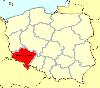
| Lower Silesian Voivodeship  FeatureType : adm1st Elevation : 154 Lat/Lng : 51.0872 / 16.4078 | Lower Silesian Voivodeship, or Lower Silesia ProvinceArkadiusz Belczyk, , 2002-2006. (Polish: województwo dolnośląskie), in southwestern Poland, is one of the 16 voivodeships (provinces) into which Poland is divided. Lower Silesia was part of Medieval Poland during the Piast dynasty (...) |
| 2 | 
| Silesian Voivodeship FeatureType : adm1st Elevation : 277 Lat/Lng : 50.3333 / 19.0003 | Silesian Voivodeship, or Silesia ProvinceArkadiusz Belczyk, , 2002-2006. is a voivodeship, or province, in southern Poland, centered on the historic region known as Upper Silesia , with Katowice serving as its capital (...) |
| 3 | 
| Żórawina FeatureType : null Elevation : 131 Lat/Lng : 50.9833 / 17.05 | Żórawina is a village in Wrocław County, Lower Silesian Voivodeship, in south-western Poland. It is the seat of the administrative district (gmina) called Gmina Żórawina. Prior to 1945 it was in Germany. The village has a population of 1,700 (...) |
| 4 | 
| Lądek-Zdrój FeatureType : city Elevation : 433 Lat/Lng : 50.3436 / 16.8797 | Lądek-Zdrój is a town in Kłodzko County, Lower Silesian Voivodeship, in south-western Poland. It is the seat of the administrative district (gmina) called Gmina Lądek-Zdrój, close to the Czech border. It lies in the Sudetes approximately south-east of Kłodzko, and south of the regional capital (...) |
| 5 | 
| Strzegom FeatureType : city Elevation : 242 Lat/Lng : 50.9611 / 16.3444 | Strzegom is a town in Świdnica County, Lower Silesian Voivodeship, in south-western Poland. It is the seat of the Gmina Strzegom administrative district (gmina). It lies approximately north-west of Świdnica, and west of the regional capital Wrocław. As at 2006, the town had a population of 16,782. (...) |
| 6 | 
| Nowa Ruda FeatureType : null Elevation : 392 Lat/Lng : 50.5797 / 16.5017 | Nowa Ruda is a town in south-western Poland near the Czech border, lying on the Włodzica river in the central Sudetes mountain range. it has 25,240 inhabitants. The town is located in Kłodzko County, Lower Silesian Voivodeship (from 1975–1998 it was in the former Wałbrzych Voivodeship) (...) |
| 7 | 
| Oleśnica FeatureType : null Elevation : 155 Lat/Lng : 51.2061 / 17.3789 | Oleśnica is a town in Lower Silesian Voivodeship, in south-western Poland. It is the administrative seat of Oleśnica County and also of the rural district of Gmina Oleśnica, although it is not part of the territory of the latter, the town being an urban gmina in its own right (...) |
| 8 | 
| Ząbkowice Śląskie FeatureType : city Elevation : 289 Lat/Lng : 50.5894 / 16.8113 | Ząbkowice Śląskie is a town in Lower Silesian Voivodeship in south-western Poland. It is the seat of Ząbkowice Śląskie County, and of the smaller administrative district (gmina) called Gmina Ząbkowice Śląskie. The town lies approximately south of the regional capital Wrocław (...) |
| 9 | 
| Sobótka FeatureType : city Elevation : 189 Lat/Lng : 50.8986 / 16.7444 | Sobótka is a town in Wrocław County, Lower Silesian Voivodeship, in south-western Poland. It is the seat of the administrative district (gmina) called Gmina Sobótka. Sobótka is located about southwest of Wrocław on the northern slope of Mount Ślęża, part of the Central Sudetes mountain range (...) |
| 10 | Karłów FeatureType : city Elevation : 756 Lat/Lng : 50.475 / 16.3389 | Karłów is a village in the administrative district of Gmina Radków, within Kłodzko County, Lower Silesian Voivodeship, in south-western Poland. It lies approximately south-west of Radków, west of Kłodzko, and south-west of the regional capital Wrocław. (...) | |
| 11 | Międzylesie FeatureType : city Elevation : 434 Lat/Lng : 50.1494 / 16.6664 | Międzylesie is a town in Kłodzko County, Lower Silesian Voivodeship, in south-western Poland. It is the seat of the administrative district (gmina) called Gmina Międzylesie, close to the Czech border. It lies approximately south of Kłodzko, and south of the regional capital Wrocław (...) | |
| 12 | 
| Dzierżoniów FeatureType : city Elevation : 278 Lat/Lng : 50.7281 / 16.6511 | Dzierżoniów (; from 1945-1946) is a town located at the foot of the Owl Mountains in southwestern Poland, within the Lower Silesian Voivodeship (from 1975–1998 in the former Wałbrzych Voivodeship). It is the seat of Dzierżoniów County, and of Gmina Dzierżoniów (although it is not part of the (...) |
| 13 | 
| Trzebnica FeatureType : null Elevation : 195 Lat/Lng : 51.305 / 17.0614 | Trzebnica (Polish pronunciation: ;) is a town in Lower Silesian Voivodeship in south-western Poland. It is the seat of Trzebnica County, and of the smaller administrative district (gmina) called Gmina Trzebnica (...) |
| 14 | 
| Gryfów Śląski FeatureType : city Elevation : 315 Lat/Lng : 51.0272 / 15.4192 | Gryfów Śląski is a town in Lwówek Śląski County, Lower Silesian Voivodeship, in south-western Poland. It is the seat of the administrative district (gmina) called Gmina Gryfów Śląski. As at 2006, the town has a population of 7,128 (...) |
| 15 | Biały Kościół, Lower Silesian Voivodeship FeatureType : city Elevation : 186 Lat/Lng : 50.7306 / 17.0367 | Biały Kościół is a village in the administrative district of Gmina Strzelin, within Strzelin County, Lower Silesian Voivodeship, in south-western Poland. It lies approximately south of Strzelin, and south of the regional capital Wrocław. The village has a population of 300. (...) | |
| 16 | Międzygórze, Lower Silesian Voivodeship FeatureType : null Elevation : 577 Lat/Lng : 50.2286 / 16.7651 | Międzygórze is a village in the administrative district of Gmina Bystrzyca Kłodzka, within Kłodzko County, Lower Silesian Voivodeship, in south-western Poland. It lies approximately south-east of Bystrzyca Kłodzka, south of Kłodzko, and south of the regional capital Wrocław (...) | |
| 17 | Pasterka, Lower Silesian Voivodeship FeatureType : null Elevation : 710 Lat/Lng : 50.4903 / 16.3281 | Pasterka is a village in the administrative district of Gmina Radków, within Kłodzko County, Lower Silesian Voivodeship, in south-western Poland. Prior to 1945 it was in Germany. It lies approximately west of Radków, west of Kłodzko, and south-west of the regional capital Wrocław (...) | |
| 18 | 
| Świdnica FeatureType : null Elevation : 237 Lat/Lng : 50.8444 / 16.4917 | Świdnica is a city in southwestern Poland in the region of Silesia. It has a population of 59,002 inhabitants according to 2014 figures. It lies in Lower Silesian Voivodeship, being the seventh largest town in that voivodeship. From 1975–98 it was in the former Wałbrzych Voivodeship (...) |
| 19 | 
| Żmigród FeatureType : city Elevation : 89 Lat/Lng : 51.4703 / 16.905 | Żmigród is a town in Trzebnica County, Lower Silesian Voivodeship, in south-western Poland. It is the seat of the administrative district (gmina) called Gmina Żmigród. (...) |
| 20 | 
| Kąty Wrocławskie FeatureType : city Elevation : 134 Lat/Lng : 51.0333 / 16.7667 | Kąty Wrocławskie is a town in Wrocław County, Lower Silesian Voivodeship, in south-western Poland. It is the seat of the administrative district (gmina) called Gmina Kąty Wrocławskie. Prior to 1945 it was in Germany. (For more information about the history of the region, see Silesia (...) |
| 21 | Łagiewniki, Lower Silesian Voivodeship FeatureType : null Elevation : 177 Lat/Lng : 50.7911 / 16.8442 | Łagiewniki is a village in Dzierżoniów County, Lower Silesian Voivodeship, in south-western Poland. It is the seat of the administrative district (gmina) called Gmina Łagiewniki. It lies approximately east of Dzierżoniów and south of the regional capital Wrocław. Prior to 1945 it was in Germany (...) | |
| 22 | Barkowo, Lower Silesian Voivodeship FeatureType : city Elevation : 89 Lat/Lng : 51.4764 / 16.7981 | Barkowo is a village in the administrative district of Gmina Żmigród, within Trzebnica County, Lower Silesian Voivodeship, in south-western Poland. Prior to 1945 it was in Germany. It lies approximately west of Żmigród, north-west of Trzebnica, and north-west of the regional capital Wrocław. (...) | |
| 23 | Gilów, Lower Silesian Voivodeship FeatureType : null Elevation : 273 Lat/Lng : 50.7219 / 16.7611 | Gilów is a village in the administrative district of Gmina Niemcza, within Dzierżoniów County, Lower Silesian Voivodeship, in south-western Poland. It lies approximately west of Niemcza, east of Dzierżoniów, and south-west of the regional capital Wrocław. The village has a population of 700. (...) | |
| 24 | 
| Legnica FeatureType : city Elevation : 124 Lat/Lng : 51.2083 / 16.1603 | Legnica (archaic Polish: Lignica) is a city in southwestern Poland, in the central part of Lower Silesia, on the Kaczawa River (left tributary of the Oder) and the Czarna Woda. Between 1 June 1975 and 31 December 1998 Legnica was the capital of the Legnica Voivodeship (...) |
| 25 | 
| Nysa, Poland FeatureType : city Elevation : 191 Lat/Lng : 50.4667 / 17.3333 | Nysa (or Neiße) is a town in southwestern Poland on the Eastern Neisse (Nysa Kłodzka) river, situated in the Opole Voivodeship. With 44,419 inhabitants (2016), it is the capital of Nysa County. It comprises the urban portion of the surrounding Gmina Nysa (...) |
| 26 | 
| Kamienna Góra FeatureType : null Elevation : 446 Lat/Lng : 50.7833 / 16.0333 | Kamienna Góra (Kamenná Hora) is a town in south-western Poland with 21,440 inhabitants (2006). It is the seat of Kamienna Góra County, and also of the rural district called Gmina Kamienna Góra, although it is not part of the territory of the latter (the town forms a separate urban gmina) (...) |
| 27 | 
| Rybarzowice, Lower Silesian Voivodeship FeatureType : null Elevation : 181 Lat/Lng : 50.9028 / 14.9 | Rybarzowice is a former village in the administrative district of Gmina Bogatynia, within Zgorzelec County, Lower Silesian Voivodeship, in south-western Poland, close to the Czech and German borders. Prior to 1945 it was in Germany (...) |
| 28 | 
| Niemcza FeatureType : city Elevation : 212 Lat/Lng : 50.7167 / 16.8333 | Niemcza is a town in Dzierżoniów County, Lower Silesian Voivodeship, in south-western Poland. It is the seat of the administrative district (gmina) called Gmina Niemcza. The town lies on the Ślęza River, approximately east of Dzierżoniów, and south of the regional capital Wrocław (...) |
| 29 | 
| Jelenia Góra FeatureType : null Elevation : 342 Lat/Lng : 50.9033 / 15.7344 | Jelenia Góra (; ; Exonym: Deer Mountain) is a city in Lower Silesia, south-western Poland. Jelenia Góra is located within the Lower Silesian Voivodeship, close to the Krkonoše mountain range running along the Polish-Czech border – ski resorts such as Karpacz and Szklarska Poręba are situated from (...) |
| 30 | Gmina Długołęka FeatureType : null Elevation : 127 Lat/Lng : 51.1747 / 17.1953 | __NOTOC__ Gmina Długołęka is a rural gmina (administrative district) in Wrocław County, Lower Silesian Voivodeship, in south-western Poland. Its seat is the village of Długołęka, which lies approximately north-east of the regional capital Wrocław (...) | |
| 31 | 
| Lubsko FeatureType : city Elevation : 71 Lat/Lng : 51.7856 / 14.9675 | Lubsko (Lower Sorbian: Žemŕ) is a town in Żary County in the Lubusz Voivodeship in western Poland. It is the administrative seat of the Gmina Lubsko and has a population of 15,370 as of February 1, 2005. (...) |
| 32 | Jugów FeatureType : null Elevation : 503 Lat/Lng : 50.6342 / 16.5118 | Jugów is a village in the administrative district of Gmina Nowa Ruda, within Kłodzko County, Lower Silesian Voivodeship, in south-western Poland. Prior to 1945 it was in Germany. It lies approximately north of Nowa Ruda, north-west of Kłodzko, and south-west of the regional capital Wrocław (...) | |
| 33 | Przeworno FeatureType : city Elevation : 197 Lat/Lng : 50.6833 / 17.0167 | Przeworno is a village in Strzelin County, Lower Silesian Voivodeship, in south-western Poland. It is the seat of the administrative district (gmina) called Gmina Przeworno. Prior to 1945 it was in Germany. It lies approximately south of Strzelin, and south of the regional capital Wrocław (...) | |
| 34 | Lubomierz FeatureType : city Elevation : 350 Lat/Lng : 51.0167 / 15.5167 | Lubomierz is a town in Lwówek Śląski County, Lower Silesian Voivodeship, in south-western Poland. It is the seat of the administrative district (gmina) called Gmina Lubomierz. It lies approximately south-west of Lwówek Śląski, and west of the regional capital Wrocław (...) | |
| 35 | Tłumaczów FeatureType : null Elevation : 359 Lat/Lng : 50.55 / 16.4167 | Tłumaczów is a village in the administrative district of Gmina Radków, within Kłodzko County, Lower Silesian Voivodeship, in south-western Poland, near the border with the Czech Republic. It lies approximately north of Radków, north-west of Kłodzko, and south-west of the regional capital Wrocław. (...) | |
| 36 | Ołdrzychowice Kłodzkie FeatureType : null Elevation : 478 Lat/Lng : 50.35 / 16.7 | Ołdrzychowice Kłodzkie is a village in the administrative district of Gmina Kłodzko, within Kłodzko County, Lower Silesian Voivodeship, in south-western Poland. Prior to 1945 it was in Germany. It lies approximately south-east of Kłodzko, and south of the regional capital Wrocław (...) | |
| 37 | 
| Lubiąż FeatureType : city Elevation : 105 Lat/Lng : 51.2667 / 16.4667 | Lubiąż is a village on the east bank of the Odra (Oder) River, in the administrative district of Gmina Wołów, within Wołów County, Lower Silesian Voivodeship, in south-western Poland. It lies approximately south-west of Wołów, and west of the regional capital Wrocław (...) |
| 38 | Laski, Lower Silesian Voivodeship FeatureType : null Elevation : 378 Lat/Lng : 50.448 / 16.7949 | Laski is a village in the administrative district of Gmina Złoty Stok, within Ząbkowice Śląskie County, Lower Silesian Voivodeship, in south-western Poland, close to the Czech border. Prior to 1945 it was in Germany (...) | |
| 39 | Wrocław FeatureType : null Elevation : 118 Lat/Lng : 51.1167 / 17.0333 | Wrocław is a city in western Poland and the largest city in the historical region of Silesia. It lies on the banks of the River Oder in the Silesian Lowlands of Central Europe, roughly 350 kilometres (220 mi) from the Baltic Sea to the north and 40 kilometres (25 mi) from the Sudeten Mountains to (...) | |
| 40 | Gmina Żórawina FeatureType : null Elevation : 131 Lat/Lng : 50.9833 / 17.05 | __NOTOC__ Gmina Żórawina is a rural gmina (administrative district) in Wrocław County, Lower Silesian Voivodeship, in south-western Poland. Its seat is the village of Żórawina, which lies approximately south of the regional capital Wrocław (...) | |
| 41 | Gmina Sobótka FeatureType : null Elevation : 189 Lat/Lng : 50.8986 / 16.7444 | __NOTOC__ Gmina Sobótka is an urban-rural gmina (administrative district) in Wrocław County, Lower Silesian Voivodeship, in south-western Poland. Its seat is the town of Sobótka, which lies approximately south-west of the regional capital Wrocław (...) | |
| 42 | Gmina Czernica FeatureType : null Elevation : 126 Lat/Lng : 51.0464 / 17.2439 | __NOTOC__ Gmina Czernica is a rural gmina (administrative district) in Wrocław County, Lower Silesian Voivodeship, in south-western Poland. Its seat is the village of Czernica, which lies approximately south-east of the regional capital Wrocław (...) | |
| 43 | Długołęka, Lower Silesian Voivodeship FeatureType : city Elevation : 127 Lat/Lng : 51.1747 / 17.1953 | Długołęka is a village in Wrocław County, Lower Silesian Voivodeship, in south-western Poland. It is the seat of the administrative district (gmina) called Gmina Długołęka. The first references to the village date back to the 13th century. Prior to 1945 it was in Germany (...) | |
| 44 | Jaszkowa Górna FeatureType : null Elevation : 367 Lat/Lng : 50.4022 / 16.7511 | Jaszkowa Górna is a village in the administrative district of Gmina Kłodzko, within Kłodzko County, Lower Silesian Voivodeship, in south-western Poland. Prior to 1945 it was in Germany known as Oberhannsdorf. It lies approximately south-east of Kłodzko, and south of the regional capital Wrocław. (...) | |
| 45 | Bukowiec, Jelenia Góra County FeatureType : null Elevation : 409 Lat/Lng : 50.8244 / 15.8169 | Bukowiec is a village in the administrative district of Gmina Mysłakowice, within Jelenia Góra County, Lower Silesian Voivodeship, in south-western Poland. It lies approximately south-east of Mysłakowice, south-east of Jelenia Góra, and west of the regional capital Wrocław (...) | |
| 46 | Żelowice FeatureType : city Elevation : 230 Lat/Lng : 50.7256 / 16.9078 | Żelowice is a village in the administrative district of Gmina Kondratowice, within Strzelin County, Lower Silesian Voivodeship, in south-western Poland. Prior to 1945 it was in Germany. It lies approximately south of Kondratowice, south-west of Strzelin, and south of the regional capital Wrocław (...) | |
| 47 | Henryków, Lower Silesian Voivodeship FeatureType : city Elevation : 204 Lat/Lng : 50.6526 / 17.0108 | Henryków is a village in the administrative district of Gmina Ziębice, within Ząbkowice Śląskie County, Lower Silesian Voivodeship, in south-western Poland. Prior to 1945 it was in Germany. It lies approximately north of Ziębice, north-east of Ząbkowice Śląskie, and south of the regional capital (...) | |
| 48 | Głuszyca FeatureType : city Elevation : 457 Lat/Lng : 50.6833 / 16.3667 | Głuszyca is a town in Wałbrzych County, Lower Silesian Voivodeship, in south-western Poland. As at 2006, the town has a population of 6,999. It is the seat of the administrative district (gmina) called Gmina Głuszyca, close to the Czech border (...) | |
| 49 | 
| Wambierzyce FeatureType : null Elevation : 365 Lat/Lng : 50.4892 / 16.4561 | Wambierzyce , the "Silesian Jerusalem", is one of the most popular pilgrimage sites in southern Poland. The village is situated at an altitude of 370–410 m in the picturesque Cedron valley on the eastern slopes of the Table Mountains in Lower Silesian Voivodeship (...) |
| 50 | 
| Bolesławiec FeatureType : null Elevation : 191 Lat/Lng : 51.2667 / 15.5667 | Bolesławiec is a town located on the Bóbr River in the Lower Silesian Voivodeship in southwestern Poland, with 40,837 inhabitants (2006). It is the administrative seat of Bolesławiec County, and of Gmina Bolesławiec (although it is not part of the territory of the latter, the town being an urban (...) |
| 51 | 
| Bystrzyca Kłodzka FeatureType : null Elevation : 371 Lat/Lng : 50.3 / 16.65 | Bystrzyca Kłodzka is a historic town in Kłodzko County, in Lower Silesian Voivodeship in southwestern Poland. It is the administrative seat of Gmina Bystrzyca Kłodzka. The old town of Bystrzyca is famous for its many historical buildings and is a popular tourist destination. (...) |
| 52 | Gmina Miękinia FeatureType : null Elevation : 135 Lat/Lng : 51.1667 / 16.7667 | __NOTOC__ Gmina Miękinia is a rural gmina (administrative district) in Środa Śląska County, Lower Silesian Voivodeship, in south-western Poland. Its seat is the village of Miękinia, which lies approximately east of Środa Śląska, and west of the regional capital Wrocław (...) | |
| 53 | Jagielno, Lower Silesian Voivodeship FeatureType : city Elevation : 212 Lat/Lng : 50.6336 / 17.2044 | Jagielno is a village in the administrative district of Gmina Przeworno, within Strzelin County, Lower Silesian Voivodeship, in south-western Poland. Prior to 1945 it was in Germany. It lies approximately south-east of Przeworno, south-east of Strzelin, and south of the regional capital Wrocław. (...) | |
| 54 | Jeleniów, Lower Silesian Voivodeship FeatureType : null Elevation : 395 Lat/Lng : 50.4233 / 16.2572 | Jeleniów is a village in the administrative district of Gmina Lewin Kłodzki, within Kłodzko County, Lower Silesian Voivodeship, in south-western Poland. It lies approximately west of Lewin Kłodzki, west of Kłodzko, and south-west of the regional capital Wrocław. The village has a population of 620 (...) | |
| 55 | Bierkowice, Lower Silesian Voivodeship FeatureType : null Elevation : 313 Lat/Lng : 50.4773 / 16.6059 | Bierkowice is a village in the administrative district of Gmina Kłodzko, within Kłodzko County, Lower Silesian Voivodeship, in south-western Poland. Prior to 1945 it was in Germany. It lies approximately north-west of Kłodzko, and south-west of the regional capital Wrocław. (...) | |
| 56 | Żelazno, Lower Silesian Voivodeship FeatureType : city Elevation : 318 Lat/Lng : 50.3767 / 16.6708 | Żelazno (Polish pronunciation: ;) is a historical village in the administrative district of Gmina Kłodzko, within Kłodzko County, Lower Silesian Voivodeship, in south-western Poland. It lies approximately south of Kłodzko and south of the regional capital Wrocław. The population as of 2017 is 973 (...) | |
| 57 | Gmina Wąsosz, Lower Silesian Voivodeship FeatureType : null Elevation : 84 Lat/Lng : 51.55 / 16.7 | __NOTOC__ Gmina Wąsosz is an urban-rural gmina (administrative district) in Góra County, Lower Silesian Voivodeship, in south-western Poland. Its seat is the town of Wąsosz, which lies approximately south-east of Góra and north-west of the regional capital Wrocław (...) | |
| 58 | Gmina Radków, Lower Silesian Voivodeship FeatureType : null Elevation : 374 Lat/Lng : 50.5039 / 16.4033 | __NOTOC__ Gmina Radków is an urban-rural gmina (administrative district) in Kłodzko County, Lower Silesian Voivodeship, in south-western Poland. Its seat is the town of Radków, which lies approximately north-west of Kłodzko, and south-west of the regional capital Wrocław (...) | |
| 59 | 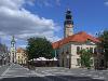
| Zielona Góra FeatureType : null Elevation : 136 Lat/Lng : 51.9397 / 15.505 | Zielona Góra is the largest city in Lubusz Voivodeship, in western Poland, with 139,813 inhabitants (2017). Zielona Góra has been in Lubusz Voivodeship since 1999, prior to which it was the capital of Zielona Góra Voivodeship from 1950 to 1998 (...) |
| 60 | Raciborowice Górne FeatureType : null Elevation : 222 Lat/Lng : 51.2 / 15.7 | Raciborowice Górne is a village in the administrative district of Gmina Warta Bolesławiecka, within Bolesławiec County, Lower Silesian Voivodeship, in south-western Poland. It lies approximately south-east of Warta Bolesławiecka, south-east of Bolesławiec, and west of the regional capital Wrocław (...) | |
| 61 | 
| Żagań FeatureType : city Elevation : 101 Lat/Lng : 51.6167 / 15.3167 | Żagań (French and) is a town on the Bóbr river in western Poland, with 26,253 inhabitants (2010). The town is the capital of Żagań County in the historic region of Silesia. Previously in the Zielona Góra Voivodeship (1975–1998), Żagań has been in the Lubusz Voivodeship since 1999 (...) |
| 62 | Jordanów Śląski FeatureType : null Elevation : 153 Lat/Lng : 50.8619 / 16.8658 | Jordanów Śląski is a village in Wrocław County, Lower Silesian Voivodeship, in south-western Poland. It is the seat of the administrative district (gmina) called Gmina Jordanów Śląski. It lies approximately south of the regional capital Wrocław. The village has a population of 1,148. (...) | |
| 63 | Sulistrowiczki FeatureType : city Elevation : 293 Lat/Lng : 50.85 / 16.7333 | Sulistrowiczki is a village in the administrative district of Gmina Sobótka, within Wrocław County, Lower Silesian Voivodeship, in south-western Poland. It lies approximately south-west of the regional capital Wrocław. (...) | |
| 64 | 
| Greater Poland Voivodeship FeatureType : adm1st Elevation : 98 Lat/Lng : 52.3339 / 17.2472 | Greater Poland Voivodeship (in Polish: Województwo Wielkopolskie), also known as Wielkopolska Voivodeship, Wielkopolska Province,Arkadiusz Belczyk, , 2002-2006. or Greater Poland Province, is a voivodeship, or province, in west-central Poland (...) |
| 65 | Janowice Wielkie FeatureType : city Elevation : 424 Lat/Lng : 50.8667 / 15.9167 | Janowice Wielkie is a village in Jelenia Góra County, Lower Silesian Voivodeship, in south-western Poland. It is the seat of the administrative district (gmina) called Gmina Janowice Wielkie. It lies approximately east of Jelenia Góra and west of the regional capital Wrocław (...) | |
| 66 | Stronie Śląskie FeatureType : city Elevation : 490 Lat/Lng : 50.2956 / 16.8775 | Stronie Śląskie is a town in Kłodzko County, Lower Silesian Voivodeship, in south-western Poland. It is the seat of the administrative district (gmina) called Gmina Stronie Śląskie, close to the Czech border. It lies approximately south-east of Kłodzko, and south of the regional capital Wrocław (...) | |
| 67 | Przemków FeatureType : city Elevation : 149 Lat/Lng : 51.5267 / 15.7847 | Przemków is a town in Polkowice County, Lower Silesian Voivodeship, in southwestern Poland. It is the seat of the administrative district called Gmina Przemków. The town lies approximately west of Polkowice, and northwest of regional capital Wrocław. Prior to 1945 it was in Germany (...) | |
| 68 | 
| Staniszów FeatureType : null Elevation : 406 Lat/Lng : 50.8497 / 15.7261 | Staniszów (German: Stonsdorf) is a village in the administrative district of Gmina Podgórzyn, within Jelenia Góra County, Lower Silesian Voivodeship, in south-western Poland. It lies approximately south of Jelenia Góra, and west of the regional capital Wrocław. Prior to 1945 it was in Germany (...) |
| 69 | Gmina Polkowice FeatureType : null Elevation : 169 Lat/Lng : 51.5 / 16.0667 | __NOTOC__ Gmina Polkowice is an urban-rural gmina (administrative district) in Polkowice County, Lower Silesian Voivodeship, in south-western Poland. Its seat is the town of Polkowice, which lies approximately north-west of the regional capital Wrocław (...) | |
| 70 | Gmina Żukowice FeatureType : null Elevation : 83 Lat/Lng : 51.6756 / 15.9825 | __NOTOC__ Gmina Żukowice is a rural gmina (administrative district) in Głogów County, Lower Silesian Voivodeship, in south-western Poland. Its seat is the village of Żukowice, which lies approximately west of Głogów and north-west of the regional capital Wrocław (...) | |
| 71 | Gmina Chocianów FeatureType : null Elevation : 144 Lat/Lng : 51.4167 / 15.9167 | __NOTOC__ Gmina Chocianów is an urban-rural gmina (administrative district) in Polkowice County, Lower Silesian Voivodeship, in south-western Poland. Its seat is the town of Chocianów, which lies approximately south-west of Polkowice, and west of the regional capital Wrocław (...) | |
| 72 | Gmina Borów FeatureType : null Elevation : 144 Lat/Lng : 50.8831 / 16.9903 | __NOTOC__ Gmina Borów is a rural gmina (administrative district) in Strzelin County, Lower Silesian Voivodeship, in south-western Poland. Its seat is the village of Borów, which lies approximately north-west of Strzelin, and south of the regional capital Wrocław (...) | |
| 73 | Gmina Domaniów FeatureType : null Elevation : 147 Lat/Lng : 50.8939 / 17.1289 | __NOTOC__ Gmina Domaniów is a rural gmina (administrative district) in Oława County, Lower Silesian Voivodeship, in south-western Poland. Its seat is the village of Domaniów, which lies approximately west of Oława, and south of the regional capital Wrocław (...) | |
| 74 | Gmina Ciepłowody FeatureType : null Elevation : 278 Lat/Lng : 50.6667 / 16.9 | __NOTOC__ Gmina Ciepłowody is a rural gmina (administrative district) in Ząbkowice Śląskie County, Lower Silesian Voivodeship, in south-western Poland. Its seat is the village of Ciepłowody, which lies approximately north-east of Ząbkowice Śląskie, and south of the regional capital Wrocław (...) | |
| 75 | Gmina Przeworno FeatureType : null Elevation : 197 Lat/Lng : 50.6833 / 17.0167 | __NOTOC__ Gmina Przeworno is a rural gmina (administrative district) in Strzelin County, Lower Silesian Voivodeship, in south-western Poland. Its seat is the village of Przeworno, which lies approximately south of Strzelin, and south of the regional capital Wrocław (...) | |
| 76 | Gmina Wądroże Wielkie FeatureType : null Elevation : 171 Lat/Lng : 51.1167 / 16.3333 | Gmina Wądroże Wielkie is a rural gmina (administrative district) in Jawor County, Lower Silesian Voivodeship, in south-western Poland. Its seat is the village of Wądroże Wielkie, which lies approximately north-east of Jawor and west of the regional capital Wrocław (...) | |
| 77 | Gmina Walim FeatureType : null Elevation : 525 Lat/Lng : 50.6981 / 16.445 | __NOTOC__ Gmina Walim is a rural gmina (administrative district) in Wałbrzych County, Lower Silesian Voivodeship, in south-western Poland. Its seat is the village of Walim, which lies approximately south-east of Wałbrzych, and south-west of the regional capital Wrocław (...) | |
| 78 | Gmina Kostomłoty FeatureType : null Elevation : 169 Lat/Lng : 51.0456 / 16.6114 | __NOTOC__ Gmina Kostomłoty is a rural gmina (administrative district) in Środa Śląska County, Lower Silesian Voivodeship, in south-western Poland. Its seat is the village of Kostomłoty, which lies approximately south of Środa Śląska and west of the regional capital Wrocław (...) | |
| 79 | Gmina Łagiewniki FeatureType : null Elevation : 177 Lat/Lng : 50.7911 / 16.8442 | __NOTOC__ Gmina Łagiewniki is a rural gmina (administrative district) in Dzierżoniów County, Lower Silesian Voivodeship, in south-western Poland. Its seat is the village of Łagiewniki, which lies approximately east of Dzierżoniów and south of the regional capital Wrocław (...) | |
| 80 | Gmina Marcinowice FeatureType : null Elevation : 215 Lat/Lng : 50.8667 / 16.5833 | __NOTOC__ Gmina Marcinowice is a rural gmina (administrative district) in Świdnica County, Lower Silesian Voivodeship, in south-western Poland. Its seat is the village of Marcinowice, which lies approximately east of Świdnica and south-west of the regional capital Wrocław (...) | |
| 81 | Gmina Męcinka FeatureType : null Elevation : 219 Lat/Lng : 51.0722 / 16.0931 | __NOTOC__ Gmina Męcinka is a rural gmina (administrative district) in Jawor County, Lower Silesian Voivodeship, in south-western Poland. Its seat is the village of Męcinka, which lies approximately west of Jawor and west of the regional capital Wrocław (...) | |
| 82 | Gmina Krotoszyce FeatureType : null Elevation : 150 Lat/Lng : 51.15 / 16.05 | __NOTOC__ Gmina Krotoszyce is a rural gmina (administrative district) in Legnica County, Lower Silesian Voivodeship, in south-western Poland. Its seat is the village of Krotoszyce, which lies approximately south-west of Legnica and west of the regional capital Wrocław (...) | |
| 83 | Gmina Paszowice FeatureType : city Elevation : 213 Lat/Lng : 51.0167 / 16.1667 | __NOTOC__ Gmina Paszowice is a rural area - gmina (administrative district) in Jawor County, Lower Silesian Voivodeship, in south-western Poland. Its seat is the village of Paszowice, which lies approximately south of Jawor and west of the regional capital Wrocław (...) | |
| 84 | Gmina Żmigród FeatureType : null Elevation : 89 Lat/Lng : 51.4703 / 16.905 | __NOTOC__ Gmina Żmigród is an urban-rural gmina (administrative district) in Trzebnica County, Lower Silesian Voivodeship, in south-western Poland. Its seat is the town of Żmigród, which lies approximately north-west of Trzebnica, and north of the regional capital Wrocław (...) | |
| 85 | Gmina Grębocice FeatureType : null Elevation : 87 Lat/Lng : 51.5981 / 16.1658 | __NOTOC__ Gmina Grębocice is a rural gmina (administrative district) in Polkowice County, Lower Silesian Voivodeship, in south-western Poland. Its seat is the village of Grębocice, which lies approximately north-east of Polkowice, and north-west of the regional capital Wrocław (...) | |
| 86 | Gmina Krośnice FeatureType : null Elevation : 126 Lat/Lng : 51.4667 / 17.3667 | __NOTOC__ Gmina Krośnice is a rural gmina (administrative district) in Milicz County, Lower Silesian Voivodeship, in south-western Poland. Its seat is the village of Krośnice, which lies approximately south-east of Milicz and north-east of the regional capital Wrocław (...) | |
| 87 | Gmina Zawonia FeatureType : null Elevation : 158 Lat/Lng : 51.3161 / 17.1969 | __NOTOC__ Gmina Zawonia is a rural gmina (administrative district) in Trzebnica County, Lower Silesian Voivodeship, in south-western Poland. Its seat is the village of Zawonia, which lies approximately east of Trzebnica, and north-east of the regional capital Wrocław (...) | |
| 88 | Gmina Niechlów FeatureType : null Elevation : 79 Lat/Lng : 51.6833 / 16.3667 | __NOTOC__ Gmina Niechlów is a rural gmina (administrative district) in Góra County, Lower Silesian Voivodeship, in south-western Poland. Its seat is the village of Niechlów, which lies approximately west of Góra and north-west of the regional capital Wrocław (...) | |
| 89 | Gmina Lewin Kłodzki FeatureType : null Elevation : 500 Lat/Lng : 50.4167 / 16.2833 | Gmina Lewin Kłodzki is a rural gmina (administrative district) in Kłodzko County, Lower Silesian Voivodeship, in south-western Poland. Its seat is the village of Lewin Kłodzki, which lies approximately west of Kłodzko, and south-west of the regional capital Wrocław (...) | |
| 90 | Gmina Rudna FeatureType : city Elevation : 112 Lat/Lng : 51.5111 / 16.2633 | Gmina Rudna is a rural gmina (administrative district) in Lubin County, Lower Silesian Voivodeship, in south-western Poland. Its seat is the village of Rudna, which lies approximately north of Lubin and north-west of the regional capital Wrocław (...) | |
| 91 | Gmina Udanin FeatureType : null Elevation : 178 Lat/Lng : 51.0333 / 16.45 | __NOTOC__ Gmina Udanin is a rural gmina (administrative district) in Środa Śląska County, Lower Silesian Voivodeship, in south-western Poland. Its seat is the village of Udanin, which lies approximately south-west of Środa Śląska, and west of the regional capital Wrocław (...) | |
| 92 | Gmina Cieszków FeatureType : null Elevation : 129 Lat/Lng : 51.6333 / 17.35 | __NOTOC__ Gmina Cieszków is a rural gmina (administrative district) in Milicz County, Lower Silesian Voivodeship, in south-western Poland. Its seat is the village of Cieszków, which lies approximately north-east of Milicz, and north of the regional capital Wrocław (...) | |
| 93 | Gmina Jemielno FeatureType : null Elevation : 108 Lat/Lng : 51.5242 / 16.5444 | __NOTOC__ Gmina Jemielno is a rural gmina (administrative district) in Góra County, Lower Silesian Voivodeship, in southwestern Poland. Its seat is the village of Jemielno, which lies approximately south of Góra and north-west of Wrocław, the regional capital (...) | |
| 94 | Gmina Kondratowice FeatureType : null Elevation : 168 Lat/Lng : 50.7739 / 16.9353 | __NOTOC__ Gmina Kondratowice is a rural gmina (administrative district) in Strzelin County, Lower Silesian Voivodeship, in south-western Poland. Its seat is the village of Kondratowice, which lies approximately west of Strzelin, and south of the regional capital Wrocław (...) | |
| 95 | Domaniów, Lower Silesian Voivodeship FeatureType : city Elevation : 147 Lat/Lng : 50.8939 / 17.1289 | Domaniów is a village in Oława County, Lower Silesian Voivodeship, in south-western Poland. It is the seat of the administrative district (gmina) called Gmina Domaniów. It lies approximately west of Oława, and south of the regional capital Wrocław. (...) | |
| 96 | Roztoka, Lower Silesian Voivodeship FeatureType : city Elevation : 231 Lat/Lng : 50.9664 / 16.2317 | Roztoka is a village in the administrative district of Gmina Dobromierz, within Świdnica County, Lower Silesian Voivodeship, in south-western Poland. It lies approximately north of Dobromierz, north-west of Świdnica, and west of the regional capital Wrocław. The village has a population of 1,098. (...) | |
| 97 | Bobolice, Lower Silesian Voivodeship FeatureType : city Elevation : 313 Lat/Lng : 50.6233 / 16.8625 | Bobolice is a village in the administrative district of Gmina Ząbkowice Śląskie, within Ząbkowice Śląskie County, Lower Silesian Voivodeship, in south-western Poland. Prior to 1945 it was in Germany. It lies approximately north-east of Ząbkowice Śląskie, and south of the regional capital Wrocław. (...) | |
| 98 | Młynów, Lower Silesian Voivodeship FeatureType : null Elevation : 292 Lat/Lng : 50.483 / 16.667 | Młynów is a village in the administrative district of Gmina Kłodzko, within Kłodzko County, Lower Silesian Voivodeship, in south-western Poland. Prior to 1945 it was in Germany. It lies approximately north of Kłodzko and south of the regional capital Wrocław. (...) | |
| 99 | Roztoki, Lower Silesian Voivodeship FeatureType : city Elevation : 405 Lat/Lng : 50.1917 / 16.6703 | Roztoki is a village in the administrative district of Gmina Międzylesie, within Kłodzko County, Lower Silesian Voivodeship, in south-western Poland. Prior to 1945 it was in Germany. It lies approximately north of Międzylesie, south of Kłodzko, and south of the regional capital Wrocław. (...) | |
| 100 | Krzelów, Lower Silesian Voivodeship FeatureType : null Elevation : 93 Lat/Lng : 51.4381 / 16.5114 | Krzelów is a village in the administrative district of Gmina Wińsko, within Wołów County, Lower Silesian Voivodeship, in south-western Poland. Prior to 1945 it was in Germany. It lies approximately west of Wińsko, north-west of Wołów, and north-west of the regional capital Wrocław. (...) | |
| 101 | Droszków, Lower Silesian Voivodeship FeatureType : null Elevation : 451 Lat/Lng : 50.3947 / 16.7836 | Droszków is a village in the administrative district of Gmina Kłodzko, within Kłodzko County, Lower Silesian Voivodeship, in south-western Poland. Prior to 1945 it was in Germany. It lies approximately south-east of Kłodzko, and south of the regional capital Wrocław. (...) | |
| 102 | Miłków, Lower Silesian Voivodeship FeatureType : null Elevation : 436 Lat/Lng : 50.8097 / 15.7611 | Miłków is a village in the administrative district of Gmina Podgórzyn, within Jelenia Góra County, Lower Silesian Voivodeship, in south-western Poland. It lies approximately south of Jelenia Góra, and west of the regional capital Wrocław. (...) | |
| 103 | Kamieniec, Lower Silesian Voivodeship FeatureType : null Elevation : 384 Lat/Lng : 50.4572 / 16.5486 | Kamieniec is a village in the administrative district of Gmina Kłodzko, within Kłodzko County, Lower Silesian Voivodeship, in south-western Poland. Prior to 1945 it was in Germany. It lies approximately west of Kłodzko, and south-west of the regional capital Wrocław. (...) | |
| 104 | Wierzchosławice, Lower Silesian Voivodeship FeatureType : null Elevation : 372 Lat/Lng : 50.9 / 16.1 | Wierzchosławice is a village in the administrative district of Gmina Bolków, within Jawor County, Lower Silesian Voivodeship, in south-western Poland. Prior to 1945 it was in Germany. It lies approximately south of Bolków, south of Jawor, and west of the regional capital Wrocław (...) | |
| 105 | Mikowice, Lower Silesian Voivodeship FeatureType : city Elevation : 339 Lat/Lng : 50.4442 / 16.6067 | Mikowice is a village in the administrative district of Gmina Kłodzko, within Kłodzko County, Lower Silesian Voivodeship, in south-western Poland. Prior to 1945 it was in Germany. It lies approximately west of Kłodzko and south of the regional capital Wrocław. (...) | |
| 106 | Świerki, Lower Silesian Voivodeship FeatureType : null Elevation : 515 Lat/Lng : 50.6303 / 16.4394 | Świerki is a village in the administrative district of Gmina Nowa Ruda, within Kłodzko County, Lower Silesian Voivodeship, in south-western Poland. It lies approximately north-west of Nowa Ruda, north-west of Kłodzko, and south-west of the regional capital Wrocław. (...) | |
| 107 | Ławica, Lower Silesian Voivodeship FeatureType : city Elevation : 340 Lat/Lng : 50.4844 / 16.6619 | Ławica is a village in the administrative district of Gmina Kłodzko, within Kłodzko County, Lower Silesian Voivodeship, in south-western Poland. Prior to 1945 it was in Germany. It lies approximately north of Kłodzko and south of the regional capital Wrocław. (...) | |
| 108 | Ziębice FeatureType : city Elevation : 214 Lat/Lng : 50.5986 / 17.0381 | Ziębice is a town in Ząbkowice Śląskie County, Lower Silesian Voivodeship, in south-western Poland. It is the seat of the administrative district (gmina) called Gmina Ziębice. Prior to 1945 it was in Germany. (For more information about the history of the region, see Silesia (...) | |
| 109 | Gmina Siechnice FeatureType : null Elevation : 123 Lat/Lng : 51.0367 / 17.1525 | __NOTOC__ Gmina Siechnice is an urban-rural gmina (administrative district) in Wrocław County, Lower Silesian Voivodeship, in south-western Poland. Its seat is the town of Siechnice, which lies approximately south-east of the county and regional capital, Wrocław (...) | |
| 110 | Gmina Kąty Wrocławskie FeatureType : null Elevation : 134 Lat/Lng : 51.0333 / 16.7667 | __NOTOC__ Gmina Kąty Wrocławskie is an urban-rural gmina (administrative district) in Wrocław County, Lower Silesian Voivodeship, in south-western Poland. Its seat is the town of Kąty Wrocławskie, which lies approximately south-west of the regional capital Wrocław (...) | |
| 111 | Bielice, Lower Silesian Voivodeship FeatureType : null Elevation : 825 Lat/Lng : 50.25 / 17.0167 | Bielice is a village in the administrative district of Gmina Stronie Śląskie, within Kłodzko County, Lower Silesian Voivodeship, in south-western Poland, near the border with the Czech Republic. It lies approximately south-east of Stronie Śląskie, south-east of Kłodzko, and south of the regional (...) | |
| 112 | 
| Świebodzin FeatureType : null Elevation : 83 Lat/Lng : 52.25 / 15.5333 | Świebodzin is a town in western Poland with 21,757 inhabitants (2004). It is the capital of Świebodzin County. Since the Local Government Reorganization Act of 1998, Świebodzin has been part of Lubusz Voivodeship. It was formerly part of the Zielona Góra Voivodeship (1975–1998) (...) |
| 113 | 
| Żary FeatureType : null Elevation : 158 Lat/Lng : 51.6333 / 15.1333 | Żary is a town in western Poland with 39,900 inhabitants (2006), situated in the Lubusz Voivodeship since 1999. Previously it was located within Zielona Góra Voivodeship (1975–1998). It is the administrative seat of the Gmina Żary, though the town is not part of the gmina commune (...) |
| 114 | Wąsosz FeatureType : city Elevation : 88 Lat/Lng : 51.5631 / 16.6919 | Wąsosz is a town in Góra County, Lower Silesian Voivodeship, in south-western Poland. It is the seat of the administrative district (gmina) called Gmina Wąsosz. It lies approximately south-east of Góra, and north-west of the regional capital Wrocław. The rivers Orla and Barycz meet here (...) | |
| 115 | Ciepłowody FeatureType : city Elevation : 278 Lat/Lng : 50.6667 / 16.9 | Ciepłowody is a village in Ząbkowice Śląskie County, Lower Silesian Voivodeship, in south-western Poland. It is the seat of the administrative district (gmina) called Gmina Ciepłowody. It lies approximately north-east of Ząbkowice Śląskie, and south of the regional capital Wrocław (...) | |
| 116 | Gmina Gaworzyce FeatureType : null Elevation : 155 Lat/Lng : 51.6281 / 15.8806 | __NOTOC__ Gmina Gaworzyce is a rural gmina (administrative district) in Polkowice County, Lower Silesian Voivodeship, in south-western Poland. Its seat is the village of Gaworzyce, which lies approximately north-west of Polkowice, and north-west of the regional capital Wrocław (...) | |
| 117 | Gorzuchów FeatureType : null Elevation : 309 Lat/Lng : 50.4903 / 16.5772 | Gorzuchów is a village in the administrative district of Gmina Kłodzko, within Kłodzko County, Lower Silesian Voivodeship, in south-western Poland. Prior to 1945 it was in Germany. It lies approximately north-west of Kłodzko, and south-west of the regional capital Wrocław. (...) | |
| 118 | Gmina Osiecznica FeatureType : null Elevation : 187 Lat/Lng : 51.3275 / 15.4194 | __NOTOC__ Gmina Osiecznica is a rural gmina (administrative district) in Bolesławiec County, Lower Silesian Voivodeship, in south-western Poland. Its seat is the village of Osiecznica, which lies approximately north-west of Bolesławiec and west of the regional capital Wrocław (...) | |
| 119 | Gmina Dobromierz FeatureType : null Elevation : 297 Lat/Lng : 50.9111 / 16.2386 | __NOTOC__ Gmina Dobromierz is a rural gmina (administrative district) in Świdnica County, Lower Silesian Voivodeship, in south-western Poland. Its seat is the village of Dobromierz, which lies approximately north-west of Świdnica, and south-west of the regional capital Wrocław (...) | |
| 120 | Gmina Gromadka FeatureType : null Elevation : 150 Lat/Lng : 51.36 / 15.7589 | __NOTOC__ Gmina Gromadka is a rural gmina (administrative district) in Bolesławiec County, Lower Silesian Voivodeship, in southwestern Poland. Its seat is the village of Gromadka, which lies approximately north-east of Bolesławiec and west of the regional capital Wrocław (...) | |
| 121 | Gmina Pęcław FeatureType : null Elevation : 77 Lat/Lng : 51.6439 / 16.2414 | __NOTOC__ Gmina Pęcław is a rural gmina (administrative district) in Głogów County, Lower Silesian Voivodeship, in south-western Poland. Its seat is the village of Pęcław, which lies approximately east of Głogów and north-west of the regional capital Wrocław (...) | |
| 122 | Krosnowice FeatureType : null Elevation : 304 Lat/Lng : 50.3871 / 16.6334 | Krosnowice (formerly Rankowo) is a village in the administrative district of Gmina Kłodzko, within Kłodzko County, Lower Silesian Voivodeship, in south-western Poland. Prior to 1945 it was in Germany. It lies approximately south of Kłodzko, and south of the regional capital Wrocław (...) | |
| 123 | Gmina Radwanice FeatureType : null Elevation : 133 Lat/Lng : 51.5667 / 15.9333 | __NOTOC__ Gmina Radwanice is a rural gmina (administrative district) in Polkowice County, Lower Silesian Voivodeship, in south-western Poland. Its seat is the village of Radwanice, which lies approximately north-west of Polkowice, and north-west of the regional capital Wrocław (...) | |
| 124 | Gmina Pielgrzymka FeatureType : null Elevation : 223 Lat/Lng : 51.1197 / 15.8153 | __NOTOC__ Gmina Pielgrzymka is a rural gmina (administrative district) in Złotoryja County, Lower Silesian Voivodeship, in south-western Poland. Its seat is the village of Pielgrzymka, which lies approximately west of Złotoryja, and west of the regional capital Wrocław (...) | |
| 125 | Gmina Miłkowice FeatureType : null Elevation : 124 Lat/Lng : 51.2575 / 16.0567 | Gmina Miłkowice is a rural gmina (administrative district) in Legnica County, Lower Silesian Voivodeship, in south-western Poland. Its seat is the village of Miłkowice, which lies approximately north-west of Legnica, and west of the regional capital Wrocław (...) | |
| 126 | Gmina Jerzmanowa FeatureType : null Elevation : 218 Lat/Lng : 51.6 / 16.05 | Gmina Jerzmanowa is a rural gmina (administrative district) in Głogów County, Lower Silesian Voivodeship, in south-western Poland. Its seat is the village of Jerzmanowa, which lies approximately south of Głogów and north-west of the regional capital Wrocław (...) | |
| 127 | Pastewnik, Lower Silesian Voivodeship FeatureType : null Elevation : 570 Lat/Lng : 50.8833 / 16.0333 | Pastewnik is a village in the administrative district of Gmina Marciszów, within Kamienna Góra County, Lower Silesian Voivodeship, in south-western Poland. It lies approximately north of Kamienna Góra, and west of the regional capital Wrocław. (...) | |
| 128 | Borowice, Lower Silesian Voivodeship FeatureType : null Elevation : 659 Lat/Lng : 50.7892 / 15.695 | Borowice is a village in the administrative district of Gmina Podgórzyn, within Jelenia Góra County, Lower Silesian Voivodeship, in south-western Poland. It lies approximately south of Jelenia Góra, and west of the regional capital Wrocław. (...) | |
| 129 | Silesia FeatureType : null Elevation : 118 Lat/Lng : 51.1035 / 17.0396 | Silesia (;. Random House Webster's Unabridged Dictionary. ; ; Schlesien.ogg ; Silesian German: Schläsing; Silesian: Ślůnsk ; ; ;) is a historical region of Central Europe located mostly in Poland, with small parts in the Czech Republic and Germany (...) | |
| 130 | Krzeszów, Lower Silesian Voivodeship FeatureType : city Elevation : 472 Lat/Lng : 50.7342 / 16.0642 | Krzeszów is a village in south-western Poland. It is part of the administrative district of Gmina Kamienna Góra, within Kamienna Góra County, Lower Silesian Voivodeship (formerly in Jelenia Góra Voivodeship). Krzeszów boasts the former Grüssau Abbey, one of the most valuable relics of Baroque (...) | |
| 131 | Gmina Kobierzyce FeatureType : null Elevation : 146 Lat/Lng : 50.9667 / 16.9167 | __NOTOC__ Gmina Kobierzyce is a rural gmina (administrative district) in Wrocław County, Lower Silesian Voivodeship, in south-western Poland. Its seat is the village of Kobierzyce. The gmina covers an area of , and as of 2008 its total population is 14,508 (...) | |
| 132 | Lubin FeatureType : null Elevation : 125 Lat/Lng : 51.3975 / 16.2094 | Lubin, is a town in Lower Silesian Voivodeship in south-western Poland. From 1975–1998 it belonged to the former Legnica Voivodeship. Lubin is the administrative seat of Lubin County, and also of the rural district called Gmina Lubin, although it is not part of the territory of the latter, as (...) | |
| 133 | Góra FeatureType : city Elevation : 85 Lat/Lng : 51.6667 / 16.55 | Góra is a town in Lower Silesian Voivodeship, in south-western Poland. It is the administrative seat both of Góra County and of the smaller district (gmina) called Gmina Góra. (...) | |
| 134 | Węgliniec FeatureType : city Elevation : 195 Lat/Lng : 51.2883 / 15.2256 | Węgliniec is a town in Zgorzelec County, Lower Silesian Voivodeship, in south-western Poland. It is the seat of the administrative district (gmina) called Gmina Węgliniec. Before 1945, the village was in Germany and known as Kohlfurt (...) | |
| 135 | Mieroszów FeatureType : city Elevation : 491 Lat/Lng : 50.6669 / 16.1897 | Mieroszów is a town in Wałbrzych County, Lower Silesian Voivodeship, in south-western Poland, near the border with the Czech Republic. It is the seat of the administrative district (gmina) called Gmina Mieroszów. Prior to 1945 it was, along with the whole region, a part of Germany (...) | |
| 136 | Gmina Wisznia Mała FeatureType : null Elevation : 149 Lat/Lng : 51.25 / 17.0333 | __NOTOC__ Gmina Wisznia Mała is a rural gmina (administrative district) in Trzebnica County, Lower Silesian Voivodeship, in south-western Poland. Its seat is the village of Wisznia Mała. The gmina covers an area of , and as of 2006 its total population is 7,981. (...) | |
| 137 | Gościsław, Lower Silesian Voivodeship FeatureType : city Elevation : 183 Lat/Lng : 51.0156 / 16.5028 | Gościsław is a village in the administrative district of Gmina Udanin, within Środa Śląska County, Lower Silesian Voivodeship, in south-western Poland. Prior to 1945 the village was in Germany and known as Bertholdsdorf (...) | |
| 138 | Karczowice, Lower Silesian Voivodeship FeatureType : city Elevation : 251 Lat/Lng : 50.6664 / 16.8581 | Karczowice is a village in the administrative district of Gmina Ciepłowody, within Ząbkowice Śląskie County, Lower Silesian Voivodeship, in south-western Poland. Prior to 1945 it was in Germany. It lies approximately west of Ciepłowody, north of Ząbkowice Śląskie, and south of the regional capital (...) | |
| 139 | Stolec, Lower Silesian Voivodeship FeatureType : city Elevation : 342 Lat/Lng : 50.6 / 16.8833 | Stolec (translation: Stool;) is a village in the administrative district of Gmina Ząbkowice Śląskie, within Ząbkowice Śląskie County, Lower Silesian Voivodeship, in south-western Poland. Prior to 1945 it was in Germany (...) | |
| 140 | Nowina, Lower Silesian Voivodeship FeatureType : city Elevation : 300 Lat/Lng : 50.6833 / 17.1 | Nowina is a village in the administrative district of Gmina Ziębice, within Ząbkowice Śląskie County, Lower Silesian Voivodeship, in south-western Poland. Prior to 1945 it was in Germany. It lies approximately north-east of Ziębice, north-east of Ząbkowice Śląskie, and south of the regional capital (...) | |
| 141 | Kamieńczyk, Lower Silesian Voivodeship FeatureType : null Elevation : 485 Lat/Lng : 50.1231 / 16.6594 | Kamieńczyk is a village in the administrative district of Gmina Międzylesie, within Kłodzko County, Lower Silesian Voivodeship, in south-western Poland, near the border with the Czech Republic. Prior to 1945 it was in Germany (...) | |
| 142 | 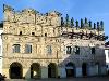
| Poland FeatureType : country Elevation : 110 Lat/Lng : 52.2323 / 21.0084 | Poland , officially the Republic of Poland , is a country located in Central Europe. It is divided into 16 administrative subdivisions, covering an area of , and has a largely temperate seasonal climate. With a population of approximately 38 (...) |
| 143 | 
| Legnickie Pole FeatureType : city Elevation : 164 Lat/Lng : 51.15 / 16.25 | Legnickie Pole (in 1945-1948 Dobre Pole) is a village in Legnica County, Lower Silesian Voivodeship, in south-western Poland. It is the seat of the administrative district (gmina) called Gmina Legnickie Pole. It lies approximately southeast of Legnica, and west of the regional capital Wrocław (...) |
| 144 | Kondratowice FeatureType : city Elevation : 166 Lat/Lng : 50.7722 / 16.9322 | Kondratowice is a village in Strzelin County, Lower Silesian Voivodeship, in south-western Poland. It is the seat of the administrative district (gmina) called Gmina Kondratowice. It lies approximately west of Strzelin, and south of the regional capital Wrocław. The village has a population of 820. (...) | |
| 145 | Jegłowa FeatureType : city Elevation : 176 Lat/Lng : 50.7314 / 17.1564 | Jegłowa is a village in the administrative district of Gmina Przeworno, within Strzelin County, Lower Silesian Voivodeship, in south-western Poland. Prior to 1945 it was in Germany. It lies approximately north-east of Przeworno, south-east of Strzelin, and south of the regional capital Wrocław (...) | |
| 146 | Prusice FeatureType : city Elevation : 116 Lat/Lng : 51.3711 / 16.9619 | Prusice is a town in Trzebnica County, Lower Silesian Voivodeship, in south-western Poland. It is the seat of the administrative district (gmina) called Gmina Prusice. The town lies approximately north-west of Trzebnica, and north of the regional capital Wrocław (...) | |
| 147 | Rybnica Leśna FeatureType : city Elevation : 688 Lat/Lng : 50.7 / 16.2833 | Rybnica Leśna is a village in the administrative district of Gmina Mieroszów, within Wałbrzych County, Lower Silesian Voivodeship, in south-western Poland. It lies approximately north-east of Mieroszów, south of Wałbrzych, and south-west of the regional capital Wrocław (...) | |
| 148 | Wińsko FeatureType : city Elevation : 163 Lat/Lng : 51.4667 / 16.6 | Wińsko is a village in Wołów County, Lower Silesian Voivodeship, in south-western Poland. It is the seat of the administrative district (gmina) called Gmina Wińsko. It lies approximately north of Wołów, and north-west of the regional capital Wrocław. The village has a population of 1,600. (...) | |
| 149 | Rososznica FeatureType : city Elevation : 275 Lat/Lng : 50.6 / 16.95 | Rososznica is a village in the administrative district of Gmina Ziębice, within Ząbkowice Śląskie County, Lower Silesian Voivodeship, in south-western Poland. Prior to 1945 it was in Germany. It lies approximately west of Ziębice, east of Ząbkowice Śląskie, and south of the regional capital Wrocław (...) | |
| 150 | Gołogłowy FeatureType : null Elevation : 295 Lat/Lng : 50.4683 / 16.6225 | Gołogłowy is a village in the administrative district of Gmina Kłodzko, within Kłodzko County, Lower Silesian Voivodeship, in south-western Poland. Prior to 1945 it was a part of Germany. It lies approximately north-west of Kłodzko, and south of the regional capital Wrocław. (...) | |
| 151 | Stary Wielisław FeatureType : null Elevation : 343 Lat/Lng : 50.4006 / 16.5644 | Stary Wielisław is a village in the administrative district of Gmina Kłodzko, within Kłodzko County, Lower Silesian Voivodeship, in south-western Poland. Prior to 1945 it was in Germany. It lies approximately south-west of Kłodzko, and south of the regional capital Wrocław (...) | |
| 152 | Jemielno FeatureType : null Elevation : 108 Lat/Lng : 51.5242 / 16.5444 | Jemielno is a village in Góra County, Lower Silesian Voivodeship, in south-western Poland. It is the seat of the administrative district (gmina) called Gmina Jemielno. It lies approximately south of Góra, and north-west of the regional capital Wrocław. (...) | |
| 153 | Ścinawka Dolna FeatureType : null Elevation : 309 Lat/Lng : 50.4958 / 16.5375 | Ścinawka Dolna is a village in the administrative district of Gmina Radków, within Kłodzko County, Lower Silesian Voivodeship, in south-western Poland. It lies approximately east of Radków, north-west of Kłodzko, and south-west of the regional capital Wrocław. (...) | |
| 154 | Kletno FeatureType : null Elevation : 851 Lat/Lng : 50.2511 / 16.8608 | Kletno is a village in the administrative district of Gmina Stronie Śląskie, within Kłodzko County, Lower Silesian Voivodeship, in south-western Poland. Prior to 1945 it was in Germany. It lies approximately east of Stronie Śląskie, south-east of Kłodzko, and south of the regional capital Wrocław. (...) | |
| 155 | Radochów FeatureType : null Elevation : 400 Lat/Lng : 50.35 / 16.8333 | Radochów is a village in the administrative district of Gmina Lądek-Zdrój, within Kłodzko County, Lower Silesian Voivodeship, in south-western Poland. Prior to 1945 it was in Germany. It lies approximately west of Lądek-Zdrój, south-east of Kłodzko, and south of the regional capital Wrocław (...) | |
| 156 | Przerzeczyn-Zdrój FeatureType : null Elevation : 263 Lat/Lng : 50.6833 / 16.8167 | Przerzeczyn-Zdrój is a village in the administrative district of Gmina Niemcza, within Dzierżoniów County, Lower Silesian Voivodeship, in south-western Poland. It lies approximately south of Niemcza, east of Dzierżoniów, and south of the regional capital Wrocław. The village has a population of 700 (...) | |
| 157 | Podlesie, Dzierżoniów County FeatureType : null Elevation : 277 Lat/Lng : 50.6833 / 16.8667 | Podlesie is a village in the administrative district of Gmina Niemcza, within Dzierżoniów County, Lower Silesian Voivodeship, in south-western Poland. It lies approximately south-east of Niemcza, east of Dzierżoniów, and south of the regional capital Wrocław. The village has a population of 200. (...) | |
| 158 | Szalejów Górny FeatureType : null Elevation : 355 Lat/Lng : 50.4333 / 16.55 | Szalejów Górny is a village in the administrative district of Gmina Kłodzko, within Kłodzko County, Lower Silesian Voivodeship, in south-western Poland. Prior to 1945 it was in Germany. It lies approximately west of Kłodzko, and south-west of the regional capital Wrocław. (...) | |
| 159 | Męcinka FeatureType : city Elevation : 219 Lat/Lng : 51.0722 / 16.0931 | Męcinka is a village in Jawor County, Lower Silesian Voivodeship, in south-western Poland. It is the seat of the administrative district (gmina) called Gmina Męcinka. It lies approximately west of Jawor and west of the regional capital Wrocław. (...) | |
| 160 | Korytów, Kłodzko County FeatureType : city Elevation : 346 Lat/Lng : 50.4556 / 16.6028 | Korytów is a village in the administrative district of Gmina Kłodzko, within Kłodzko County, Lower Silesian Voivodeship, in south-western Poland. Prior to 1945 it was in Germany. It lies approximately north-west of Kłodzko and south of the regional capital Wrocław. (...) | |
| 161 | Wolbromek FeatureType : null Elevation : 270 Lat/Lng : 50.9333 / 16.1667 | Wolbromek is a village in the administrative district of Gmina Bolków, within Jawor County, Lower Silesian Voivodeship, in south-western Poland. Prior to 1945 it was in Germany. It lies approximately east of Bolków, south of Jawor, and west of the regional capital Wrocław (...) | |
| 162 | Dobra, Bolesławiec County FeatureType : null Elevation : 205 Lat/Lng : 51.2758 / 15.5125 | Dobra is a village in the administrative district of Gmina Bolesławiec, within Bolesławiec County, Lower Silesian Voivodeship, in south-western Poland. It lies approximately west of Bolesławiec, and west of the regional capital Wrocław. (...) | |
| 163 | Lipa, Jawor County FeatureType : null Elevation : 363 Lat/Lng : 50.9667 / 16.0333 | Lipa is a village in the administrative district of Gmina Bolków, within Jawor County, Lower Silesian Voivodeship, in south-western Poland. Prior to 1945 it was in Germany. It lies approximately north-west of Bolków, south-west of Jawor, and west of the regional capital Wrocław (...) | |
| 164 | Piszkowice FeatureType : city Elevation : 330 Lat/Lng : 50.4689 / 16.5894 | Piszkowice is a village in the administrative district of Gmina Kłodzko, within Kłodzko County, Lower Silesian Voivodeship, in south-western Poland. Prior to 1945 it was in Germany. It lies approximately north-west of Kłodzko and south-west of the regional capital Wrocław. (...) | |
| 165 | Jaszkowa Dolna FeatureType : null Elevation : 306 Lat/Lng : 50.4167 / 16.6667 | Jaszkowa Dolna is a village in the administrative district of Gmina Kłodzko, within Kłodzko County, Lower Silesian Voivodeship, in south-western Poland. Prior to 1945 it was in Germany. It lies approximately east of Kłodzko, and south of the regional capital Wrocław (...) | |
| 166 | 
| Gross-Rosen concentration camp FeatureType : landmark Elevation : 242 Lat/Lng : 50.9972 / 16.2773 | Gross-Rosen concentration camp was a German network of Nazi concentration camps built and operated during World War II. The main camp was located in the German village of Gross-Rosen, now the modern-day Rogoźnica in Lower Silesian Voivodeship, Poland; directly on the rail-line between the towns of (...) |
| 167 | Gmina Oborniki Śląskie FeatureType : null Elevation : 152 Lat/Lng : 51.2986 / 16.9017 | __NOTOC__ Gmina Oborniki Śląskie is an urban-rural gmina (administrative district) in Trzebnica County, Lower Silesian Voivodeship, in south-western Poland. Its seat is the town of Oborniki Śląskie, which lies approximately west of Trzebnica, and north-west of the regional capital Wrocław (...) | |
| 168 | Wiązów FeatureType : city Elevation : 150 Lat/Lng : 50.8153 / 17.2036 | Wiązów is a town in Strzelin County, Lower Silesian Voivodeship, in south-western Poland. It is the seat of the administrative district (gmina) called Gmina Wiązów. The town lies approximately east of Strzelin, and south of the regional capital Wrocław. As at 2016, the town has a population of 2,310 (...) | |
| 169 | Pęcław, Lower Silesian Voivodeship FeatureType : null Elevation : 77 Lat/Lng : 51.6439 / 16.2414 | Pęcław is a village in Głogów County, Lower Silesian Voivodeship, in south-western Poland. It is the seat of the administrative district (gmina) called Gmina Pęcław. It lies approximately east of Głogów, and north-west of the regional capital Wrocław (...) | |
| 170 | Gmina Mietków FeatureType : null Elevation : 160 Lat/Lng : 50.9833 / 16.65 | __NOTOC__ Gmina Mietków is a rural gmina (administrative district) in Wrocław County, Lower Silesian Voivodeship, in south-western Poland. Its seat is the village of Mietków, which lies approximately south-west of the regional capital Wrocław (...) | |
| 171 | Gmina Jordanów Śląski FeatureType : null Elevation : 153 Lat/Lng : 50.8619 / 16.8658 | __NOTOC__ Gmina Jordanów Śląski is a rural gmina (administrative district) in Wrocław County, Lower Silesian Voivodeship, in south-western Poland. Its seat is the village of Jordanów Śląski, which lies approximately south of the regional capital Wrocław (...) | |
| 172 | 
| Zaporizhia FeatureType : null Elevation : 54 Lat/Lng : 47.8333 / 35.1667 | Zaporizhia (Zaporizhzhya) or Zaporozhye , formerly Alexandrovsk , is a city in southeastern Ukraine, situated on the banks of the Dnieper River. It is the administrative centre of the Zaporizhia Oblast (region). The city population is the sixth largest in Ukraine , UkrStat.gov.ua (2016) (...) |
| 173 | Jelcz-Laskowice FeatureType : city Elevation : 135 Lat/Lng : 51.0333 / 17.3333 | Jelcz-Laskowice is a town in Oława County, Lower Silesian Voivodeship, in south-western Poland. It is the seat of the administrative district (gmina) called Gmina Jelcz-Laskowice. It lies on the Odra (Oder) river, approximately north of Oława, and south-east of the regional capital Wrocław (...) | |
| 174 | Dobromierz, Lower Silesian Voivodeship FeatureType : city Elevation : 299 Lat/Lng : 50.9114 / 16.2387 | Dobromierz is a village-sized municipality in Świdnica County, Lower Silesian Voivodeship, in south-western Poland. The municipality lies approximately north-west of Świdnica, and south-west of the regional capital Wrocław. It has a population of 800 (...) | |
| 175 | Kobierzyce FeatureType : city Elevation : 146 Lat/Lng : 50.9667 / 16.9167 | Kobierzyce is a village in Wrocław County, Lower Silesian Voivodeship, in south-western Poland. It is the seat of the administrative district (gmina) called Gmina Kobierzyce. Prior to 1945 it belonged to Germany. It lies approximately south-west of the capital of Lower Silesian Voivodeship Wrocław (...) | |
| 176 | Czernica, Wrocław County FeatureType : city Elevation : 126 Lat/Lng : 51.0464 / 17.2439 | Czernica is a village in Wrocław County, Lower Silesian Voivodeship, in south-western Poland. It is the seat of the administrative district (gmina) called Gmina Czernica. Prior to 1945 it was in Germany. It lies approximately south-east of the regional capital Wrocław (...) | |
| 177 | Bielany Wrocławskie FeatureType : city Elevation : 129 Lat/Lng : 51.0333 / 16.9667 | Bielany Wrocławskie is a village in the administrative district of Gmina Kobierzyce, within Wrocław County, Lower Silesian Voivodeship, in south-western Poland. Prior to 1945 it was in Germany. It lies approximately south-west of the Wrocław centrum (...) | |
| 178 | Bardo, Poland FeatureType : city Elevation : 307 Lat/Lng : 50.5086 / 16.7439 | Bardo is a town in Ząbkowice Śląskie County, Lower Silesian Voivodeship, in south-western Poland. It is the seat of the administrative district (gmina) called Gmina Bardo. Bardo lies on the Nysa Kłodzka river, flowing out of the Kłodzko Valley towards the Silesian Lowlands (...) | |
| 179 | Pławna Dolna FeatureType : city Elevation : 255 Lat/Lng : 51.0622 / 15.6003 | Pławna Dolna is a village in the administrative district of Gmina Lubomierz, within Lwówek Śląski County, Lower Silesian Voivodeship, in south-western Poland. Prior to 1945 it was in Germany. It lies approximately north-east of Lubomierz, south of Lwówek Śląski, and west of the regional capital (...) | |
| 180 | Olszyna FeatureType : city Elevation : 255 Lat/Lng : 51.0667 / 15.3889 | Olszyna is a town in Lubań County, Lower Silesian Voivodeship, in south-western Poland. Its name means "alder wood" in Polish. It is the seat of the administrative district (gmina) called Gmina Olszyna. It received its town charter in 2005 (...) | |
| 181 | Świerzawa FeatureType : city Elevation : 264 Lat/Lng : 51.0147 / 15.8928 | Świerzawa is a town in Złotoryja County, Lower Silesian Voivodeship, in south-western Poland. It is the seat of the administrative district (gmina) called Gmina Świerzawa. Prior to 1945 it was in Germany. (For more information about the history of the region, see Silesia (...) | |
| 182 | Ludwikowice Kłodzkie FeatureType : city Elevation : 451 Lat/Lng : 50.6178 / 16.4783 | Ludwikowice Kłodzkie is a village in the administrative district of Gmina Nowa Ruda, within Kłodzko County, Lower Silesian Voivodeship, in south-western Poland. Prior to 1945 it was in Germany. It lies approximately north of Nowa Ruda, north-west of Kłodzko, and south-west of the regional capital (...) | |
| 183 | Suchy Dwór, Lower Silesian Voivodeship FeatureType : null Elevation : 129 Lat/Lng : 51.0167 / 17.0167 | Suchy Dwór is a village in the administrative district of Gmina Żórawina, within Wrocław County, Lower Silesian Voivodeship, in south-western Poland. It lies approximately north-west of Żórawina and south of the regional capital Wrocław. Prior to 1945 the village was in Germany and named Althofdürr (...) | |
| 184 | Wleń FeatureType : city Elevation : 227 Lat/Lng : 51.0167 / 15.6706 | Wleń is a town in Lwówek Śląski County, Lower Silesian Voivodeship, in south-western Poland. It is located on the Bóbr river in the historic Lower Silesian region, approximately south-east of Lwówek Śląski, and west of the regional capital Wrocław (...) | |
| 185 | Syców FeatureType : city Elevation : 166 Lat/Lng : 51.3 / 17.7167 | Syców (until 1888 Polnisch Wartenberg) is a town in Oleśnica County, Lower Silesian Voivodeship, in south-western Poland. It is the seat of the administrative district (gmina) called Gmina Syców. It lies approximately north-east of Oleśnica, and north-east of the regional capital Wrocław. (...) | |
| 186 | Kamieniec Ząbkowicki FeatureType : city Elevation : 249 Lat/Lng : 50.5333 / 16.8833 | Kamieniec Ząbkowicki is a village in Ząbkowice Śląskie County, Lower Silesian Voivodeship, in south-western Poland. It is the seat of the administrative district (gmina) called Gmina Kamieniec Ząbkowicki. Prior to 1945 it was in Germany under the name of Kamenz (...) | |
| 187 | Kłaczyna FeatureType : city Elevation : 248 Lat/Lng : 50.945 / 16.2008 | Kłaczyna is a village in the administrative district of Gmina Dobromierz, within Świdnica County, Lower Silesian Voivodeship, in south-western Poland. It lies approximately north-west of Dobromierz, north-west of Świdnica, and west of the regional capital Wrocław. (...) | |
| 188 | Bożanów FeatureType : city Elevation : 203 Lat/Lng : 50.9217 / 16.5064 | Bożanów is a village in the administrative district of Gmina Żarów, within Świdnica County, Lower Silesian Voivodeship, in south-western Poland. It lies approximately south-east of Żarów, north-east of Świdnica, and south-west of the regional capital Wrocław. (...) | |
| 189 | Jaszkówka FeatureType : null Elevation : 386 Lat/Lng : 50.4369 / 16.6981 | Jaszkówka is a village in the administrative district of Gmina Kłodzko, within Kłodzko County, Lower Silesian Voivodeship, in south-western Poland. Prior to 1945 it was in Germany. It lies approximately east of Kłodzko, and south of the regional capital Wrocław. (...) | |
| 190 | Strużnica FeatureType : null Elevation : 493 Lat/Lng : 50.8333 / 15.8667 | Strużnica (; see) is a village in the administrative district of Gmina Mysłakowice, within Jelenia Góra County, Lower Silesian Voivodeship, in south-western Poland. It lies approximately south-east of Jelenia Góra, and west of the regional capital Wrocław. (...) | |
| 191 | Długopole Górne FeatureType : null Elevation : 414 Lat/Lng : 50.2333 / 16.65 | Długopole Górne (German:Oberlangenau) is a village in the administrative district of Gmina Międzylesie, within Kłodzko County, Lower Silesian Voivodeship, in south-western Poland. It lies approximately north of Międzylesie, south of Kłodzko, and south of the regional capital Wrocław. (...) | |
| 192 | Jaworzyna Śląska FeatureType : city Elevation : 226 Lat/Lng : 50.9167 / 16.4333 | Jaworzyna Śląska (German: Königszelt) is a town in Świdnica County, Lower Silesian Voivodeship, in south-western Poland. It is the seat of the administrative district (gmina) called Gmina Jaworzyna Śląska. The town lies approximately north of Świdnica, and south-west of the regional capital Wrocław (...) | |
| 193 | Gmina Strzelin FeatureType : null Elevation : 166 Lat/Lng : 50.7833 / 17.0667 | __NOTOC__ Gmina Strzelin is an urban-rural gmina (administrative district) in Strzelin County, Lower Silesian Voivodeship, in south-western Poland. Its seat is the town of Strzelin, which lies approximately south of the regional capital Wrocław (...) | |
| 194 | Gmina Mirsk FeatureType : null Elevation : 356 Lat/Lng : 50.9692 / 15.3828 | Gmina Mirsk is an urban rural gmina (administrative district) in Lwówek Śląski County, Lower Silesian Voivodeship, in south-western Poland, on the Czech border. Its seat is the town of Mirsk, which lies approximately south-west of Lwówek Śląski, and west of the regional capital Wrocław (...) | |
| 195 | Gmina Trzebnica FeatureType : null Elevation : 195 Lat/Lng : 51.305 / 17.0614 | __NOTOC__ Gmina Trzebnica is an urban-rural gmina (administrative district) in Trzebnica County, Lower Silesian Voivodeship, in south-western Poland. Its seat is the town of Trzebnica, which lies approximately north of the regional capital Wrocław (...) | |
| 196 | Gmina Lądek-Zdrój FeatureType : null Elevation : 433 Lat/Lng : 50.3436 / 16.8797 | Gmina Lądek-Zdrój is an urban-rural gmina (administrative district) in Kłodzko County, Lower Silesian Voivodeship, in south-western Poland. Its seat is the town of Lądek-Zdrój, which lies approximately south-east of Kłodzko, and south of the regional capital Wrocław (...) | |
| 197 | Gmina Strzegom FeatureType : null Elevation : 242 Lat/Lng : 50.9611 / 16.3444 | __NOTOC__ Gmina Strzegom is an urban-rural gmina (administrative district) in Świdnica County, Lower Silesian Voivodeship, in south-western Poland. Its seat is the town of Strzegom, which lies approximately north-west of Świdnica, and west of the regional capital Wrocław (...) | |
| 198 | Gmina Żarów FeatureType : null Elevation : 220 Lat/Lng : 50.9333 / 16.4833 | __NOTOC__ Gmina Żarów is an urban-rural gmina (administrative district) in Świdnica County, Lower Silesian Voivodeship, in south-western Poland. Its seat is the town of Żarów, which lies approximately north-east of Świdnica, and south-west of the regional capital Wrocław (...) | |
| 199 | Gmina Ząbkowice Śląskie FeatureType : null Elevation : 262 Lat/Lng : 50.5833 / 16.8167 | __NOTOC__ Gmina Ząbkowice Śląskie is an urban-rural gmina (administrative district) in Ząbkowice Śląskie County, Lower Silesian Voivodeship, in south-western Poland. Its seat is the town of Ząbkowice Śląskie, which lies approximately south of the regional capital Wrocław (...) | |
| 200 | Gmina Środa Śląska FeatureType : null Elevation : 117 Lat/Lng : 51.15 / 16.5833 | __NOTOC__ Gmina Środa Śląska is an urban-rural gmina (administrative district) in Środa Śląska County, Lower Silesian Voivodeship, in south-western Poland. Its seat is the town of Środa Śląska, which lies approximately west of the regional capital Wrocław (...) | |
 by
by