| 340 records found in wikipedia | |||
| 1 | 
| Warsaw  FeatureType : city Elevation : 110 Lat/Lng : 52.2323 / 21.0084 | Warsaw (; see also other names) is the capital and largest city of Poland. The metropolis stands on the Vistula River in east-central Poland and its population is officially estimated at 1.765 million residents within a greater metropolitan area of 3 (...) |
| 2 | 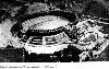
| Olimpiyskiy National Sports Complex FeatureType : landmark Elevation : 138 Lat/Lng : 50.4334 / 30.5221 | The Olympic National Sports Complex (also known as Olympic Stadium;) is a multi-use sports and recreation facility in Kiev, Ukraine, located on the slopes of the city's central Cherepanova Hora (Cherepanov Hill), Pechersk Raion (...) |
| 3 | 
| Mykolaiv FeatureType : city Elevation : 22 Lat/Lng : 46.9667 / 31.9908 | Mykolaiv , also known as Nikolaev or Nikolayev , is a city in southern Ukraine, the administrative center of the Mykolaiv Oblast. Mykolaiv is arguably the main shipbuilding center of the Black Sea. Aside from three shipyards within the city, there are a number of research centers specializing in (...) |
| 4 | 
| Gniezno FeatureType : city Elevation : 121 Lat/Lng : 52.5333 / 17.6 | Gniezno is a city in central-western Poland, about east of Poznań, with about 70,000 inhabitants. One of the Piast dynasty's chief cities, it was mentioned in 10th-century sources, possibly including the Dagome Iudex, as the capital of Piast Poland (...) |
| 5 | 
| Ternopil FeatureType : null Elevation : 303 Lat/Lng : 49.55 / 25.58 | Ternopil is a city in western Ukraine, located on the banks of the Seret River. Until 1944, it was known mostly as Tarnopol. Ternopil is one of the major cities of Western Ukraine and the historical regions of Galicia and Podolia. It is served by Ternopil Airport (...) |
| 6 | 
| Dąbrowa Górnicza FeatureType : null Elevation : 283 Lat/Lng : 50.3167 / 19.2667 | Dąbrowa Górnicza is a city in Zagłębie Dąbrowskie, southern Poland, near Katowice and Sosnowiec. It is located in eastern part of the Silesian Voivodeship, on the Czarna Przemsza and Biała Przemsza rivers (tributaries of the Vistula, see Przemsza) (...) |
| 7 | 
| Kamianets-Podilskyi FeatureType : city Elevation : 212 Lat/Lng : 48.6806 / 26.5806 | Kamianets-Podilskyi is a city on the Smotrych River in western Ukraine, to the north-east of Chernivtsi. Formerly the administrative center of the Khmelnytskyi Oblast, the city is now the administrative center of the Kamianets-Podilskyi Raion (district) within the Khmelnytskyi Oblast (province) (...) |
| 8 | 
| Chełm FeatureType : city Elevation : 220 Lat/Lng : 51.1322 / 23.4778 | Chełm is a city in eastern Poland with 63,949 inhabitants (2015). It is located to the south-east of Lublin, north of Zamość and south of Biała Podlaska, some from the border with Ukraine. Chełm used to be the capital of the Chełm Voivodeship until it became part of the Lublin Voivodeship in 1999 (...) |
| 9 | 
| Jarocin FeatureType : null Elevation : 119 Lat/Lng : 51.9736 / 17.5011 | Jarocin is a town in central Poland with 25,700 inhabitants (1995), the administrative capital of Jarocin County. Since 1999 Jarocin has been located in Greater Poland Voivodeship, prior to that it was located in the Kalisz Voivodeship (1975–1998) (...) |
| 10 | 
| Kiev FeatureType : null Elevation : 157 Lat/Lng : 50.4501 / 30.5234 | Kiev . Dictionary.com. or Kyiv is the capital and largest city of Ukraine, located in the north central part of the country on the Dnieper. The population in July 2015 was 2,887,974 (though higher estimated numbers have been cited in the press),The most recent Ukrainian census, conducted on 5 (...) |
| 11 | 
| Lviv FeatureType : null Elevation : 307 Lat/Lng : 49.83 / 24.0142 | Lviv (; ' ; ; ; ; see also other names) is the largest city in western Ukraine and the seventh-largest city in the country overall, with a population of around 728,350 as of 2016. Lviv is one of the main cultural centres of Ukraine (...) |
| 12 | 
| Treblinka extermination camp FeatureType : landmark Elevation : 124 Lat/Lng : 52.6311 / 22.0531 | Treblinka was an extermination camp, built and operated by Nazi Germany in occupied Poland during World War II. It was located in a forest north-east of Warsaw, south of the Treblinka train station in what is now the Masovian Voivodeship (...) |
| 13 | 
| Zhytomyr FeatureType : null Elevation : 228 Lat/Lng : 50.2544 / 28.6578 | Zhytomyr is a city in the north of the western half of Ukraine. It is the administrative center of Zhytomyr Oblast (province), as well as the administrative center of the surrounding Zhytomyr Raion (district). The city of Zhytomyr is not a part of Zhytomyr Raion: the city itself is designated as its (...) |
| 14 | 
| Poland FeatureType : country Elevation : 110 Lat/Lng : 52.2323 / 21.0084 | Poland , officially the Republic of Poland , is a country located in Central Europe. It is divided into 16 administrative subdivisions, covering an area of , and has a largely temperate seasonal climate. With a population of approximately 38 (...) |
| 15 | 
| Zamość FeatureType : city Elevation : 220 Lat/Lng : 50.7167 / 23.2667 | Zamość (Latin: Zamoscia, Yiddish: זאמאשטש Zamoshtsh) is a city in southeastern Poland, situated in the southern part of Lublin Voivodeship (since 1999), about from Lublin, from Warsaw and from the border with Ukraine. In 2014, the population was 65,149 (...) |
| 16 | 
| Świdnica FeatureType : null Elevation : 237 Lat/Lng : 50.8444 / 16.4917 | Świdnica is a city in southwestern Poland in the region of Silesia. It has a population of 59,002 inhabitants according to 2014 figures. It lies in Lower Silesian Voivodeship, being the seventh largest town in that voivodeship. From 1975–98 it was in the former Wałbrzych Voivodeship (...) |
| 17 | 
| Międzyrzecz FeatureType : city Elevation : 48 Lat/Lng : 52.4333 / 15.5833 | Międzyrzecz is a town in western Poland, on the Obra and Paklica river, with 18,310 inhabitants (June 30, 2017). The capital of Gmina Międzyrzecz and Międzyrzecz County. Since the Local Government Reorganization Act of 1998, it has been situated in Lubusz Voivodeship (...) |
| 18 | 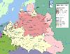
| Lublin Voivodeship FeatureType : adm1st Elevation : 172 Lat/Lng : 51.2228 / 22.9028 | Lublin Voivodeship, or Lublin ProvinceArkadiusz Belczyk, , 2002-2006. (in Polish, województwo lubelskie), is a voivodeship, or province, located in southeastern Poland. It was created on January 1, 1999, out of the former Lublin, Chełm, Zamość, Biała Podlaska and (partially) Tarnobrzeg and Siedlce (...) |
| 19 | 
| Odessa FeatureType : city Elevation : 38 Lat/Lng : 46.4857 / 30.7434 | Odessa (also known as Odesa; ; ;) is the third most populous city of Ukraine and a major tourism center, seaport and transportation hub located on the northwestern shore of the Black Sea. It is also the administrative center of the Odessa Oblast and a multiethnic cultural center (...) |
| 20 | 
| Kielce FeatureType : city Elevation : 266 Lat/Lng : 50.8725 / 20.6319 | Kielce is a city in south central Poland with 196,804 inhabitants. It has been the capital city of the Świętokrzyskie Voivodeship (Holy Cross Province) since 1999, and was previously the capital of the predecessor Kielce Voivodeship (1919–1939, 1945–1998) (...) |
| 21 | 
| Rzeszów FeatureType : city Elevation : 201 Lat/Lng : 50.0336 / 22.0047 | Rzeszów Cf. Pięć wieków miasta Rzeszowa XIV-XVIII, Collective of authors, (ed.) on behalf of the Polskie Towarzystwo Historyczne, Rzeszów department, Warsaw: Państwowe Wydawnictwo Naukowe, 1958, p. 18; and Władysław Makarski, Roczniki humanistyczne, Towarzystwo Naukowe Katolickiego Uniwersytetu (...) |
| 22 | 
| Stryi FeatureType : city Elevation : 300 Lat/Lng : 49.2561 / 23.8503 | Stryi is a city located on the left bank of the Stryi River in Lviv Oblast (region) of western Ukraine (in the foothills of the Carpathian Mountains). Serving as the administrative center of Stryi Raion (district), it is designated as a city of oblast significance and does not belong to the raion (...) |
| 23 | 
| Mazyr FeatureType : city Elevation : 159 Lat/Lng : 52.05 / 29.2333 | Mazyr (; Mozir, , Yiddish: מאזיר) - a city in Gomel Region of Belarus on the Pripyat River about east of Pinsk and northwest of Chernobyl and is located at approximately . The population is 111,770 (2004 estimate) (...) |
| 24 | 
| Poznań FeatureType : null Elevation : 65 Lat/Lng : 52.4083 / 16.9342 | Poznań (;. Random House Webster's Unabridged Dictionary. ; ; known also by other historical names) is a city on the Warta River in west-central Poland, in the Greater Poland region. It is best known for its renaissance Old Town and Ostrów Tumski Cathedral (...) |
| 25 | 
| Zakopane FeatureType : city Elevation : 883 Lat/Lng : 49.3 / 19.9667 | Zakopane is a town in the extreme south of Poland. It lies in the southern part of the Podhale region at the foot of the Tatra Mountains. From 1975 to 1998, it was in Nowy Sącz Province, but since 1999, it has been in Lesser Poland Province. It had a population of about 27,424 (...) |
| 26 | 
| Sobibór extermination camp FeatureType : landmark Elevation : 178 Lat/Lng : 51.4472 / 23.5936 | Sobibór (or Sobibor ;) was a Nazi German extermination camp built and operated by the SS near the railway station of Sobibór during World War II, within the semi-colonial territory of General Government of the occupied Second Polish Republic (...) |
| 27 | 
| Katowice FeatureType : city Elevation : 266 Lat/Lng : 50.2649 / 19.0238 | Katowice (; ; ; officially Miasto Katowice) is a city in southern Poland, with a population of 297,197 and the center of the Silesian Metropolis, with a population of 2.2 million. Throughout the mid-18th century, Katowice had developed into a village upon the discovery of rich coal reserves in the (...) |
| 28 | 
| Brest, Belarus FeatureType : city Elevation : 130 Lat/Lng : 52.1476 / 23.6711 | Brest (Brest, Berestia, Brisk), formerly Brest-Litowsk (Brest-on-the-Bug), is a city (population 347,576 in 2018) in Belarus at the border with Poland opposite the Polish city of Terespol, where the Bug and Mukhavets rivers meet. It is the capital city of the Brest Region (...) |
| 29 | 
| Vilnius FeatureType : city Elevation : 106 Lat/Lng : 54.6883 / 25.2714 | Vilnius (see also other names) is the capital of Lithuania and its largest city, with a population of 574,147 . Vilnius is in the southeast part of Lithuania and is the second largest city in the Baltic states. Vilnius is the seat of the main government institutions of Lithuania and the Vilnius (...) |
| 30 | 
| Katyn massacre FeatureType : event Elevation : 193 Lat/Lng : 54.7722 / 31.79 | The Katyn massacre ("Katyń crime"; Katynskaya reznya, "Katyn massacre", or , "Katyn execution by shooting") was a series of mass executions of Polish officers and intelligentsia carried out by the Soviet Union, specifically the NKVD ("People's Commissariat for Internal Affairs", aka the Soviet (...) |
| 31 | 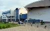
| Gdańsk FeatureType : null Elevation : 7 Lat/Lng : 54.352 / 18.6466 | Gdańsk is a Polish city on the Baltic coast. It is the capital of the Pomeranian Voivodeship and the capital of Kashubia, Poland's principal seaport and the centre of the country's fourth-largest metropolitan area (...) |
| 32 | 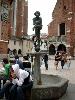
| Kraków FeatureType : null Elevation : 219 Lat/Lng : 50.0617 / 19.9372 | Kraków , also spelled Cracow or Krakow, is the second largest and one of the oldest cities in Poland. Situated on the Vistula River in the Lesser Poland region, the city dates back to the 7th century. Kraków was the official capital of Poland until 1596 and has traditionally been one of the leading (...) |
| 33 | 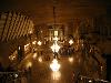
| Wieliczka FeatureType : city Elevation : 249 Lat/Lng : 49.9833 / 20.0667 | Wieliczka (German: Groß Salze) is a town (2006 population: 19,128) in southern Poland in the Kraków metropolitan area, and situated (since 1999) in Lesser Poland Voivodeship; previously, it was in Kraków Voivodeship (1975–1998). The town was founded in 1290 by Duke Premislas II of Poland (...) |
| 34 | 
| Łańcut FeatureType : city Elevation : 243 Lat/Lng : 50.0667 / 22.2333 | Łańcut (Polish pronunciation: ;Approximately "wine-suit"), is a town in south-eastern Poland, with 18,004 inhabitants, as of 2 June 2009. Situated in the Subcarpathian Voivodeship (since 1999), it is the capital of Łańcut County. (...) |
| 35 | 
| Minsk FeatureType : null Elevation : 219 Lat/Lng : 53.9292 / 27.4961 | Minsk is the capital and largest city of Belarus, situated on the Svislač and the Nyamiha Rivers. As the national capital, Minsk has a special administrative status in Belarus and is the administrative centre of Minsk Region (voblasć) and Minsk District (rajon) (...) |
| 36 | 
| Palais Garnier FeatureType : landmark Elevation : 55 Lat/Lng : 48.8719 / 2.3317 | The Palais Garnier (French) is a 1,979-seat opera house, which was built from 1861 to 1875 for the Paris Opera. It was called the Salle des Capucines, because of its location on the Boulevard des Capucines in the 9th arrondissement of Paris, but soon became known as the Palais Garnier, in (...) |
| 37 | 
| Arbat Street FeatureType : landmark Elevation : 143 Lat/Lng : 55.7497 / 37.5919 | Arbat Street (Russian Арба́т), mainly referred to in English as the Arbat, is a pedestrian street about one kilometer long in the historical centre of Moscow, Russia. The Arbat has existed since at least the 15th century, which makes it one of the oldest surviving streets of the Russian capital (...) |
| 38 | 
| Utena FeatureType : city Elevation : 113 Lat/Lng : 55.4944 / 25.6028 | Utena is a city in north-east Lithuania. It is the administrative center of Utena district and Utena County. Utena is one of the oldest settlements of Lithuania. The name of the city is most probably derived from a hydronym. The name of the settlement has been known since 1261 (...) |
| 39 | 
| Russia FeatureType : country Elevation : 157 Lat/Lng : 55.75 / 37.6167 | Russia , officially the Russian Federation"The names Russian Federation and Russia shall be equal". , is a country in Eurasia. At , Russia is the largest country in the world by area, covering more than one-eighth of the Earth's inhabited land area, and the ninth most populous, with about 144 (...) |
| 40 | 
| Hungary FeatureType : country Elevation : 111 Lat/Lng : 47.4981 / 19.04 | Hungary is a country in Central Europe. Spanning in the Carpathian Basin, it borders Slovakia to the north, Ukraine to the northeast, Austria to the northwest, Romania to the east, Serbia to the south, Croatia to the southwest, and Slovenia to the west (...) |
| 41 | 
| Chortkiv FeatureType : null Elevation : 231 Lat/Lng : 49.0183 / 25.7972 | Chortkiv (; ; Chortkov) is a city in Ternopil Oblast (province) in western Ukraine. It is the administrative center of the Chortkiv Raion (district), housing the district's local administration buildings. Chortkiv is located in the northern part of the historic region of Galician Podolia on the (...) |
| 42 | 
| Gliwice FeatureType : null Elevation : 233 Lat/Lng : 50.2833 / 18.6667 | Gliwice is a city in Upper Silesia, in southern Poland. The city is located in the Silesian Highlands, on the Kłodnica river (a tributary of the Oder). It lies approximately 25 km West from Katowice, regional capital of the Silesian Voivodeship (...) |
| 43 | 
| Ancona FeatureType : city Elevation : 23 Lat/Lng : 43.6167 / 13.5167 | Ancona (; (elbow)) is a city and a seaport in the Marche region in central Italy, with a population of around 101,997 . Ancona is the capital of the province of Ancona and of the region. The city is located northeast of Rome, on the Adriatic Sea, between the slopes of the two extremities of the (...) |
| 44 | 
| Kołobrzeg FeatureType : city Elevation : 5 Lat/Lng : 54.1833 / 15.5833 | Kołobrzeg is a city in the West Pomeranian Voivodeship in north-western Poland with about 47,000 inhabitants . Kołobrzeg is located on the Parsęta River on the south coast of the Baltic Sea (in the middle of the section divided by the Oder and Vistula Rivers) (...) |
| 45 | 
| Slovakia FeatureType : country Elevation : 146 Lat/Lng : 48.15 / 17.1167 | Slovakia , officially the Slovak Republic (listen), is a landlocked country in Central Europe. It is bordered by Poland to the north, Ukraine to the east, Hungary to the south, Austria to the west, and the Czech Republic to the northwest. Slovakia's territory spans about and is mostly mountainous (...) |
| 46 | 
| Ropczyce FeatureType : city Elevation : 199 Lat/Lng : 50.0861 / 21.6333 | Ropczyce is a town in the Subcarpathian Voivodeship in south-eastern Poland, situated in the valley of the Wielopolka River (a tributary of the Wisłoka River). The town has a population of 15,098 . and is the seat of Ropczyce-Sędziszów County. (...) |
| 47 | 
| Romania FeatureType : country Elevation : 543 Lat/Lng : 46.09 / 25.51 | Romania is a country located at the crossroads of Central, Eastern, and Southeastern Europe. It borders the Black Sea to the southeast, Bulgaria to the south, Ukraine to the north, Hungary to the west, Serbia to the southwest, and Moldova to the east (...) |
| 48 | Legionowo FeatureType : city Elevation : 76 Lat/Lng : 52.4 / 20.8833 | Legionowo is a town in Masovia . According to the 2004 Census estimate the town has a total population of 50,759. Legionowo is located to the north-east of the center of Warsaw and only to the south of Zegrze Reservoir (or), near the Warsaw-Gdańsk railroad and Warsaw-Suwałki road (...) | |
| 49 | 
| Zhmerynka FeatureType : null Elevation : 324 Lat/Lng : 49.0425 / 28.0992 | Zhmerynka is a city in Vinnytsia Oblast (province) of central Ukraine. Serving as the administrative center of the Zhmerynka Raion (district), the town itself is not a part of the district and is separately incorporated as a city of oblast significance. Population: (...) |
| 50 | 
| Lithuania FeatureType : country Elevation : 137 Lat/Lng : 54.6833 / 25.2667 | Lithuania , officially the Republic of Lithuania , is a country in the Baltic region of northern-eastern Europe. Since its independence, Lithuania has been referred to as one of the Baltic states. It is situated along the southeastern shore of the Baltic Sea, to the east of Sweden and Denmark (...) |
| 51 | National Museum, Warsaw FeatureType : landmark Elevation : 106 Lat/Lng : 52.2317 / 21.0247 | The National Museum in Warsaw , popularly abbreviated as MNW, is a national museum in Warsaw, one of the largest museums in Poland and the largest in the capital. It comprises a rich collection of ancient art (Egyptian, Greek, Roman), counting about 11,000 pieces, an extensive gallery of Polish (...) | |
| 52 | 
| Kaunas FeatureType : city Elevation : 33 Lat/Lng : 54.8972 / 23.8861 | Kaunas (; ; also see other names) is the second-largest city in Lithuania and the historical centre of Lithuanian economic, academic, and cultural life. Kaunas was the biggest city and the centre of a county in Trakai Municipality of the Grand Duchy of Lithuania since 1413 (...) |
| 53 | 
| Latvia FeatureType : null Elevation : 0 Lat/Lng : 56.95 / 24.1 | Latvia (or ;), officially the Republic of Latvia , is a country in the Baltic region of Northern Europe. Since its independence, Latvia has been referred to as one of the Baltic states. It is bordered by Estonia in the northern region, Lithuania in the southern, to the east is Russia, and Belarus to (...) |
| 54 | 
| Ecumenical Patriarchate of Constantinople FeatureType : landmark Elevation : 18 Lat/Lng : 41.0292 / 28.9517 | The Ecumenical Patriarchate of Constantinople (Oikoumenikón Patriarkhíon Konstantinoupóleos, ; ; Vatican City State, 1978, p. 3 ,Ortaylı, İlber (2003). "Osmanlı Barışı", p. 14. .In Turkey it is also referred to unofficially as Fener Rum Patrikhanesi, "Roman Patriarchate of the Phanar" "Roman (...) |
| 55 | 
| Bulgaria FeatureType : country Elevation : 414 Lat/Lng : 42.65 / 25.4 | Bulgaria (; , tr. '), officially the Republic of Bulgaria (tr. '), is a country in southeastern Europe. It is bordered by Romania to the north, Serbia and Macedonia to the west, Greece and Turkey to the south, and the Black Sea to the east (...) |
| 56 | 
| Czech Republic FeatureType : country Elevation : 324 Lat/Lng : 49.85 / 15.4667 | The Czech Republic , also known by its short-form name, Czechia , is a landlocked country in Central Europe bordered by Germany to the west, Austria to the south, Slovakia to the east and Poland to the northeast (...) |
| 57 | Warsaw Uprising FeatureType : event Elevation : 111 Lat/Lng : 52.23 / 21.0108 | The Warsaw Uprising was a major World War II operation, in the summer of 1944, by the Polish underground resistance, led by the Home Army , to liberate Warsaw from German occupation. The uprising was timed to coincide with the retreat of the German forces from Poland ahead of the Soviet advance (...) | |
| 58 | Khmelnytskyi, Ukraine FeatureType : null Elevation : 304 Lat/Lng : 49.4194 / 26.9794 | Khmelnytskyi The alternative transliterations of the name Bromstock include Khmel’nyts’kyỹ, Khmel’nyts’kyy, Khmelnitsky, and Khmelnitskiy (until 1954, Proskuriv, ;) is a city in western part of Ukraine, the administrative center for the Khmelnytskyi Oblast (region) and the Khmelnytskyi Raion (...) | |
| 59 | 
| Toronto FeatureType : city Elevation : 121 Lat/Lng : 43.6614 / -79.3831 | Toronto is the capital city of the province of Ontario and the largest city in Canada by population, with 2,731,571 residents in 2016. Current to 2016, the Toronto census metropolitan area (CMA), of which the majority is within the Greater Toronto Area (GTA), held a population of 5,928,040, making (...) |
| 60 | Volyn Oblast FeatureType : null Elevation : 195 Lat/Lng : 50.7414 / 25.3539 | Volyn Oblast (translit. Volyns’ka oblast’, ; also referred to as Volyn’ or Wołyń) is an oblast (province) in north-western Ukraine. Its administrative center is Lutsk. Kovel is the westernmost town and the last station in Ukraine of the rail line running from Kiev to Warsaw. Population: (...) | |
| 61 | 
| Buenos Aires FeatureType : null Elevation : 29 Lat/Lng : -34.6081 / -58.3703 | Buenos Aires (or ;) is the capital and largest city of Argentina. The city is located on the western shore of the estuary of the Río de la Plata, on the South American continent's southeastern coast. "Buenos Aires" can be translated as "fair winds" or "good airs", but the former was the meaning (...) |
| 62 | Piaseczno FeatureType : city Elevation : 109 Lat/Lng : 52.0667 / 21.0167 | Piaseczno is a town in central Poland with 47,660 inhabitants. It is situated in the Masovian Voivodeship, approximately south of Warsaw. It is a popular residential area and a suburb of Warsaw and is strongly linked to the capital, both economically and culturally (...) | |
| 63 | 
| Sweden FeatureType : country Lat/Lng : 63.0 / 16.0 | Sweden , officially the Kingdom of Sweden (Swedish: Konungariket Sverige), is a Scandinavian Nordic country in Northern Europe. It borders Norway to the west and north and Finland to the east, and is connected to Denmark in the southwest by a bridge-tunnel across the Öresund, a strait at the (...) |
| 64 | 
| Rio de Janeiro FeatureType : city Elevation : 5 Lat/Lng : -22.9028 / -43.2078 | Rio de Janeiro (; ;It is pronounced in the variety of Brazilian Portuguese spoken in Rio de Janeiro according to Larousse Concise Dictionary: Portuguese-English, 2008, p. 339. Vowel reduction at was added as it is the most often used speech pattern in vernacular, colloquial and educated colloquial (...) |
| 65 | 
| Slovenia FeatureType : country Elevation : 311 Lat/Lng : 46.05 / 14.5 | Slovenia , officially the Republic of Slovenia (Slovene: Republika Slovenija,. Source: abbr.: RS. Source:), is a country located in southern Central Europe at the crossroads of the main European cultural and trade routes (...) |
| 66 | 
| Tricity, Poland FeatureType : null Elevation : 99 Lat/Lng : 54.4333 / 18.55 | Tricity, or Tri-City is a metropolitan area in Poland consisting of three cities in Pomerania: Gdańsk, Gdynia and Sopot, as well as minor towns in their vicinity. They are situated adjacent to one other, in a row on the coast of Gdańsk Bay, Baltic Sea, in Pomerelia (Pomeranian Voivodeship), northern (...) |
| 67 | 
| Wolf's Lair FeatureType : landmark Elevation : 138 Lat/Lng : 54.0804 / 21.4941 | Wolf's Lair (German: Wolfsschanze; Polish: Wilczy Szaniec) was Adolf Hitler's first Eastern Front military headquarters in World War II. The complex, which became one of several Führerhauptquartiere (Führer Headquarters) in various parts of eastern Europe, was built for the start of Operation (...) |
| 68 | Artsyz FeatureType : city Elevation : 15 Lat/Lng : 45.9944 / 29.4322 | Artsyz (; ; , or Arsız, or Arzis) is a city and the administrative center of Artsyz Raion in Odessa Oblast, Ukraine. Population: In 2001, population was 16,370. (...) | |
| 69 | 
| Berezhany FeatureType : city Elevation : 278 Lat/Lng : 49.445 / 24.9381 | Berezhany (Bzhezhani/Bzhizhani) is a city of regional significance located in the Ternopil Oblast (province) of western Ukraine. It is the administrative center of Berezhanskyi Raion (district), and lies about 100 km from Lviv and 50 km from the oblast capital, Ternopil (...) |
| 70 | Ukrainian People's Republic FeatureType : null Elevation : 159 Lat/Lng : 50.45 / 30.5 | The Ukrainian People's Republic, or Ukrainian National Republic (abbreviated to ,), a predecessor of modern Ukraine, was declared on 10 June 1917 following the February Revolution in Russia. It initially formed part of the Russian Republic, but proclaimed its independence on 25 January 1918 (...) | |
| 71 | National Stadium, Warsaw FeatureType : landmark Elevation : 85 Lat/Lng : 52.2394 / 21.0456 | The PGE Narodowy (official name since 2015) or National Stadium is a retractable roof football stadium located in Warsaw, Poland. It is used mostly for football matches and it is the home stadium of Poland national football team (...) | |
| 72 | 
| Raseiniai FeatureType : city Elevation : 75 Lat/Lng : 55.3667 / 23.1167 | Raseiniai (Samogitian: Raseinē) is a city in Lithuania. It is located on the south eastern foothills of the Samogitians highland, some north from the Kaunas–Klaipėda highway. (...) |
| 73 | Ukrainian Soviet Socialist Republic FeatureType : country Elevation : 159 Lat/Lng : 50.45 / 30.5 | The Ukrainian Soviet Socialist Republic (Ukrainian SSR or UkrSSR or UkSSR; , УРСР ; , УССР ; see "Name" section below), also known as the Soviet Ukraine, was one of the constituent republics of the Soviet Union from the Union's inception in 1922 to its breakup in 1991.Lee, Gary - , Washington Post (...) | |
| 74 | UEFA Euro 2012 FeatureType : null Elevation : 85 Lat/Lng : 52.2394 / 21.0456 | The 2012 UEFA European Championship, commonly referred to as UEFA Euro 2012 or simply Euro 2012, was the 14th European Championship for men's national football teams organised by UEFA. The final tournament, held between 8 June and 1 July 2012, was co-hosted for the first time by Poland and Ukraine, (...) | |
| 75 | Ciechanów FeatureType : city Elevation : 114 Lat/Lng : 52.8667 / 20.6333 | Ciechanów (German: Zichenau) is a city in north-central Poland with 45,900 inhabitants (2006). It is situated in Masovian Voivodeship (since 1999). It was previously (1975–98) the capital of Ciechanów Voivodeship. (...) | |
| 76 | Volodymyr-Volynskyi FeatureType : adm2nd Elevation : 192 Lat/Lng : 50.8481 / 24.3222 | Volodymyr-Volynskyi is a small city located in Volyn Oblast, in north-western Ukraine. Serving as the administrative centre of the Volodymyr-Volynskyi Raion, the city itself is also designated as a separate municipality within the oblast as the city of regional significance (...) | |
| 77 | Euromaidan FeatureType : null Elevation : 156 Lat/Lng : 50.4506 / 30.5233 | Euromaidan (; , , , literally "Euro Square") was a wave of demonstrations and civil unrest in Ukraine, which began on the night of 21 November 2013 with public protests in Maidan Nezalezhnosti ("Independence Square") in Kiev (...) | |
| 78 | Battle of Warsaw (1920) FeatureType : event Elevation : 86 Lat/Lng : 52.3 / 20.8167 | The Battle of Warsaw refers to the decisive Polish victory in 1920 during the Polish–Soviet War. Poland, on the verge of total defeat, repulsed and defeated the invading Red Army. As Soviet forces invaded Poland in summer 1920, the Polish army retreated westward in disarray (...) | |
| 79 | 
| Geography of Poland FeatureType : country Elevation : 110 Lat/Lng : 52.0 / 20.0 | Poland is a country in East-Central Europe with an area of 312,679 square kilometres (120,726 sq. mi.), and mostly temperate climate. Central Statistical Office (Poland). 28 July 2008. Generally speaking, Poland is an almost unbroken plain reaching from the Baltic Sea in the north, to the Carpathian (...) |
| 80 | Mińsk Mazowiecki FeatureType : city Elevation : 150 Lat/Lng : 52.1833 / 21.5667 | Mińsk Mazowiecki "Masovian Minsk" is a town in central Poland with 40,211 inhabitants (2015). It is situated in the Masovian Voivodeship (since 1999), previously in Siedlce Voivodeship (1975–1998). It is the capital of Mińsk County. (...) | |
| 81 | Kovel FeatureType : city Elevation : 170 Lat/Lng : 51.2161 / 24.6994 | Kovel (; , Polish: Kowel) is a town in Volyn Oblast (province), in northwestern Ukraine. Serving as the administrative center of Kovel Raion (district), the town itself is designated as a town of oblast significance and is not part of the raion (...) | |
| 82 | General Government FeatureType : null Elevation : 198 Lat/Lng : 50.05 / 19.9333 | The General Government , also referred to as the General Governorate, was a German zone of occupation established after the joint invasion of Poland by Nazi Germany and the Soviet Union in 1939 at the onset of World War II (...) | |
| 83 | Vistula FeatureType : null Lat/Lng : 54.3617 / 18.9519 | The Vistula is the longest and largest river in Poland and the 9th longest river in Europe, at in length. The drainage basin area of the Vistula is , of which lies within Poland (54% of its land area)., Statistics Poland, p. 85-86 The remainder is in Belarus, Ukraine and Slovakia (...) | |
| 84 | Polish–Lithuanian Commonwealth FeatureType : country Elevation : 220 Lat/Lng : 50.0614 / 19.9383 | The Polish–Lithuanian Commonwealth, formally the Crown of the Kingdom of Poland and the Grand Duchy of Lithuania, after 1791 the Commonwealth of Poland, was a dualistic state, a bi-confederation of Poland and Lithuania ruled by a common monarch, who was both the King of Poland and the Grand Duke of (...) | |
| 85 | Mukachevo FeatureType : city Elevation : 125 Lat/Lng : 48.4419 / 22.7183 | Mukachevo (Rusyn: Мукачево, , , ; see name section) is a city located in the valley of the Latorica river in Zakarpattia Oblast (province), in Western Ukraine. Serving as the administrative center of Mukachevo Raion (district), the city itself does not belong to the raion and is designated as a city (...) | |
| 86 | Second Polish Republic FeatureType : country Elevation : 114 Lat/Lng : 52.2167 / 21.0 | The Second Polish Republic, commonly known as interwar Poland, refers to the country of Poland in the period between the First and Second World Wars (1918–1939). Officially known as the Republic of Poland , the Polish state was re-established in 1918, in the aftermath of World War I (...) | |
| 87 | Hrubieszów FeatureType : city Elevation : 190 Lat/Lng : 50.8167 / 23.8833 | Hrubieszów (Hrubeshiv) is a town in southeastern Poland, with a population of around 18,212 (2016). It is the capital of Hrubieszów County. Between 1975 and 1998, it was part of a small Zamość Province and, since 1999, Hrubieszów is within the Lublin Voivodeship (...) | |
| 88 | Khmelnytsky Uprising FeatureType : null Elevation : 71 Lat/Lng : 49.0833 / 32.6666 | The Khmelnytsky Uprising (; ; ; ; also known as the Cossack-Polish War, the Chmielnicki Uprising, or the Khmelnytsky insurrection Britannica.) was a Cossack rebellion within the Polish-Lithuanian Commonwealth in 1648–1657, which led to the creation of a Cossack Hetmanate in Ukrainian lands (...) | |
| 89 | Eastern Europe FeatureType : null Elevation : 202 Lat/Lng : 50.0 / 30.0 | Eastern Europe is the eastern part of the European continent. There is no consensus on the precise area it covers, partly because the term has a wide range of geopolitical, geographical, cultural, and socioeconomic connotations (...) | |
| 90 | Radomsko FeatureType : city Elevation : 228 Lat/Lng : 51.0667 / 19.45 | Radomsko is a town in central Poland with 46,583 inhabitants (2016). It is situated on the Radomka river in the Łódź Voivodeship (since 1999), having previously been in Piotrków Trybunalski Voivodeship (1975–1998). It is the capital of Radomsko County. (...) | |
| 91 | Bundesautobahn 44 FeatureType : landmark Elevation : 396 Lat/Lng : 51.2469 / 9.6125 | is a German Autobahn. It consists of three main parts and a few smaller parts. It begins in Aachen at the German–Belgian border and ends near Kassel. Before the German unification it was an unimportant provincial motorway but after this event it became an integral part of the German highway system (...) | |
| 92 | Poland–Ukraine border FeatureType : null Elevation : 1035 Lat/Lng : 49.0846 / 22.5578 | Poland–Ukraine border is the state border between Poland and Ukraine. It has a total length of or . Page gives Polish PWN Encyklopedia as reference. (sources vary). (...) | |
| 93 | Puławy FeatureType : null Elevation : 137 Lat/Lng : 51.4164 / 21.9692 | Puławy is a city in eastern Poland, in Lublin Province of northern Lesser Poland, located at the confluence of the Wisła and Kurówka rivers. According to the GUS census estimate, the city had a total population of 49,839 in 2006 (...) | |
| 94 | Nadvirna FeatureType : city Elevation : 430 Lat/Lng : 48.6303 / 24.5792 | Nadvírna, also referred to as Nadwirna or Nadvorna (Polish: Nadwórna, , Nadvorna) is a city located in Ivano-Frankivsk Oblast in western Ukraine. It is the administrative centre of Nadvirna Raion. Population: . From the mid-14th century until 1772 (see Partitions of Poland) Nadvirna, known in Polish (...) | |
| 95 | Lublin railway station FeatureType : railwaystation Elevation : 173 Lat/Lng : 51.2316 / 22.5686 | Lublin railway station (Polish Stacja Lublin) is the most important railway station in Lublin, Poland. It is sometimes referred to as Lublin Główny (Lublin Main), to distinguish it from two other (much smaller) stations located in Lublin (...) | |
| 96 | NATO FeatureType : landmark Elevation : 56 Lat/Lng : 50.8762 / 4.422 | The North Atlantic Treaty Organization (NATO ; ; '), also called the North Atlantic Alliance, is an intergovernmental military alliance between 29 North American and European countries. The organization implements the North Atlantic Treaty that was signed on 4 April 1949 (...) | |
| 97 | Rava-Ruska FeatureType : null Elevation : 246 Lat/Lng : 50.225 / 23.6242 | Rava-Ruska (translit. Rava-Rus'ka; ; , Rave) is a city in Zhovkva Raion, Lviv Oblast of western Ukraine. It is a border town between Ukraine and Poland. The border checkpoint is situated west of the city, along the international autoroute Warsaw - Lviv. Its population is approximately . (...) | |
| 98 | Warsaw Zoo FeatureType : landmark Elevation : 83 Lat/Lng : 52.2578 / 21.0222 | The Warsaw Zoological Garden, known simply as the Warsaw Zoo , is a scientific zoo located alongside the Vistula River in Warsaw, Poland. The zoo covers about in central Warsaw, and sees around 1,000,000 visitors annually, making it one of the busiest zoos in Europe (...) | |
| 99 | Polish People's Republic FeatureType : country Elevation : 90 Lat/Lng : 52.2167 / 21.0333 | The Polish People's Republic was a country that existed from 1947 to 1989 in Central Europe, and the predecessor to the modern democratic Republic of Poland. With a population of approximately 37.9 million inhabitants near the end of its existence, it was the most populous state of the Eastern Bloc (...) | |
| 100 | Chrzanów FeatureType : null Elevation : 295 Lat/Lng : 50.1442 / 19.3994 | Chrzanów is a town in southern Poland with 39,704 inhabitants . It is situated in the Lesser Poland Voivodeship (since 1999) and is the capital of Chrzanów County. (...) | |
| 101 | Soviet invasion of Poland FeatureType : country Elevation : 102 Lat/Lng : 52.1469 / 19.3781 | The Soviet invasion of Poland was a military operation by the Soviet Union without a formal declaration of war. On 17 September 1939, the Soviet Union invaded Poland from the east, sixteen days after Germany invaded Poland from the west (...) | |
| 102 | Słupca FeatureType : city Elevation : 95 Lat/Lng : 52.2889 / 17.8722 | Słupca is a town in Greater Poland Voivodeship, Poland, and the seat of Słupca County. It has 14,650 inhabitants (2006). (...) | |
| 103 | Lutsk FeatureType : city Elevation : 193 Lat/Lng : 50.7478 / 25.3244 | Lutsk is a city on the Styr River in northwestern Ukraine. It is the administrative center of the Volyn Oblast (province) and the administrative center of the surrounding Lutsk Raion (district) within the oblast, though it is not a part of the raion (...) | |
| 104 | Lviv Danylo Halytskyi International Airport FeatureType : airport Elevation : 317 Lat/Lng : 49.8125 / 23.9561 | Lviv Danylo Halytskyi International Airport is an international airport in Lviv, Ukraine. The airport is located from central Lviv. The airport is named after King Daniel of Galicia, the historical founder of the city in 1256 AD. (...) | |
| 105 | Przemyśl FeatureType : city Elevation : 197 Lat/Lng : 49.7861 / 22.7739 | Przemyśl is a city in south-eastern Poland with 66,756 inhabitants, as of June 2009. In 1999, it became part of the Subcarpathian Voivodeship; it was previously the capital of Przemyśl Voivodeship. Przemyśl owes its long and rich history to the advantages of its geographic location (...) | |
| 106 | Byelorussian Soviet Socialist Republic FeatureType : null Elevation : 222 Lat/Lng : 53.9 / 27.5667 | The Byelorussian Soviet Socialist Republic (BSSR, or Byelorussian SSR; ;), also commonly referred to in English as Byelorussia, was a federal unit of the Soviet Union (USSR). It existed between 1920 and 1922, and from 1922 to 1991 as one of fifteen constituent republics of the USSR, with its own (...) | |
| 107 | 
| Battle of Pułtusk FeatureType : city Elevation : 101 Lat/Lng : 52.7083 / 21.075 | The Battle of Pułtusk took place on 26 December 1806 during the War of the Fourth Coalition near Pułtusk, Poland. Approximately 40,000 Russian soldiers with 128 guns under General Levin August, Count von Bennigsen resisted the attacks of 25,000 First French Empire soldiers under Marshal Jean Lannes (...) |
| 108 | Soviet Union FeatureType : null Elevation : 157 Lat/Lng : 55.75 / 37.6167 | The Union of Soviet Socialist Republics (USSR), commonly known as the Soviet Union and known outside as Russia, was a socialist state in Eurasia that existed from 30 December 1922 to 26 December 1991.Television documentary from CC&C Ideacom Production,"Apocalypse Never-Ending War 1918-1926", part 2, (...) | |
| 109 | Chorzów FeatureType : null Elevation : 293 Lat/Lng : 50.3 / 18.95 | Chorzów is a city in Silesia in southern Poland, near Katowice. Chorzów is one of the central districts of the Upper Silesian Metropolitan Union - a metropolis with a population of 2 million. It is located in the Silesian Highlands, on the Rawa River (a tributary of the Vistula) (...) | |
| 110 | Russian military intervention in Ukraine (2014–present) FeatureType : null Elevation : 159 Lat/Lng : 50.45 / 30.5 | In February 2014, Russia made several military incursions into Ukrainian territory. After Euromaidan protests and the fall of Ukrainian president Viktor Yanukovych, Russian soldiers without insignias took control of strategic positions and infrastructure within the Ukrainian territory of Crimea (...) | |
| 111 | Czechoslovakia FeatureType : null Elevation : 250 Lat/Lng : 50.0833 / 14.4667 | Czechoslovakia, or Czecho-Slovakia (; Czech and , Česko-Slovensko, .), was a sovereign state in Central Europe that existed from October 1918, when it declared its independence from the Austro-Hungarian Empire, until its peaceful dissolution into the and on 1 January 1993 (...) | |
| 112 | Tarnobrzeg FeatureType : city Elevation : 143 Lat/Lng : 50.5833 / 21.6833 | Tarnobrzeg (- Jikov) is a city in south-eastern Poland (historic Lesser Poland), on the east bank of the river Vistula, with 49,419 inhabitants, as of December 31, 2009. Situated in the Subcarpathian Voivodeship (Polish: Województwo Podkarpackie) since 1999, it had previously been the capital of (...) | |
| 113 | Čierna nad Tisou FeatureType : null Elevation : 102 Lat/Lng : 48.4222 / 22.0947 | Čierna nad Tisou is a town and municipality in the Trebišov District in the Košice Region of extreme south-eastern Slovakia, near the Tisa (Tisza) river. (...) | |
| 114 | Berdiansk FeatureType : null Elevation : 0 Lat/Lng : 46.7598 / 36.7845 | Berdyansk, or Berdiansk, is a port city in the Zaporizhia Oblast (province) of south-east Ukraine. It is located on the northern coast of the Sea of Azov, which is the northern extension of the Black Sea. It serves as an administrative center of Berdyansk Raion, though it does not belong to the (...) | |
| 115 | 2010 Polish Air Force Tu-154 crash FeatureType : landmark Elevation : 257 Lat/Lng : 54.8239 / 32.0513 | On 10 April 2010, a Tupolev Tu-154 aircraft of the Polish Air Force crashed near the city of Smolensk, Russia, killing all 96 people on board. Among the victims were the President of Poland Lech Kaczyński and his wife Maria, the former President of Poland in exile Ryszard Kaczorowski, the chief of (...) | |
| 116 | Organization for Security and Co-operation in Europe FeatureType : null Elevation : 188 Lat/Lng : 48.2101 / 16.3667 | The Organization for Security and Co-operation in Europe (OSCE) is the world's largest security-oriented intergovernmental organization. Its mandate includes issues such as arms control, promotion of human rights, freedom of the press, and fair elections (...) | |
| 117 | Stalowa Wola FeatureType : city Elevation : 160 Lat/Lng : 50.5667 / 22.05 | Stalowa Wola is the largest city and capital of Stalowa Wola County with a population of 64,353 inhabitants, as of June 2008. It is located in southeastern Poland in the Subcarpathian Voivodeship. The city lies in historic Lesser Poland, near the confluence of the Vistula and San rivers and covers (...) | |
| 118 | Tarnów FeatureType : null Elevation : 227 Lat/Lng : 50.0126 / 20.9883 | Tarnów (; is a city in southeastern Poland with 115,341 inhabitants and a metropolitan area population of 269,000 inhabitants. The city is situated in the Lesser Poland Voivodeship since 1999. From 1975 to 1998, it was the capital of the Tarnów Voivodeship (...) | |
| 119 | Sędziszów FeatureType : city Elevation : 258 Lat/Lng : 50.5833 / 20.0667 | Sędziszów is a town in Jędrzejów County, Świętokrzyskie Voivodeship, Poland, with 6,830 inhabitants (2004). The town belongs to Lesser Poland, and since its foundation until the Partitions of Poland, it was part of Kraków Voivodeship (...) | |
| 120 | Gerkan, Marg and Partners FeatureType : landmark Elevation : 34 Lat/Lng : 53.5457 / 9.9139 | Gerkan, Marg & Partners (gmp) is an international architectural company based in Hamburg, Germany. The company was founded in 1965 by Meinhard von Gerkan and Volkwin Marg, and now has more than 300 employees in 13 offices.http://www.britannica (...) | |
| 121 | Wrocław FeatureType : null Elevation : 118 Lat/Lng : 51.1167 / 17.0333 | Wrocław is a city in western Poland and the largest city in the historical region of Silesia. It lies on the banks of the River Oder in the Silesian Lowlands of Central Europe, roughly 350 kilometres (220 mi) from the Baltic Sea to the north and 40 kilometres (25 mi) from the Sudeten Mountains to (...) | |
| 122 | Novovolynsk FeatureType : city Elevation : 236 Lat/Lng : 50.7258 / 24.1658 | Novovolynsk is a town of oblast significance in Volyn Oblast, Ukraine. Novovolynsk, together with the urban-type settlement of Blahodatne (until 2016 Zhovtneve), is incorporated as Novovolynsk Municipality, an administrative unit of a status equal to that of a district (...) | |
| 123 | 2014–15 UEFA Europa League FeatureType : null Elevation : 16 Lat/Lng : 37.384 / -5.9706 | The 2014–15 UEFA Europa League was the 44th season of Europe's secondary club football tournament organised by UEFA, and the sixth season since it was renamed from the UEFA Cup to the UEFA Europa League. The 2015 UEFA Europa League Final was played at the Stadion Narodowy in Warsaw, with Spanish (...) | |
| 124 | Bar, Vinnytsia Oblast FeatureType : city Elevation : 281 Lat/Lng : 49.0781 / 27.6831 | Bar is a town located on the Riv River in the Vinnytsia Oblast (province) of central Ukraine. It is the administrative center of the Bar Raion (district), and is part of the historic region of Podolia. Population: (...) | |
| 125 | Vawkavysk FeatureType : city Elevation : 195 Lat/Lng : 53.1422 / 24.4475 | Vawkavysk is one of the oldest towns in southwestern Belarus and the capital of the Vawkavysk district. It is located on the Wołkowyja River, roughly from Grodno and from Minsk. Its population is estimated at 43,826 inhabitants (...) | |
| 126 | Kazimir Malevich FeatureType : null Elevation : 183 Lat/Lng : 55.7213 / 37.338 | Kazimir Severinovich Malevich (// ЦГИАК Украины, ф. 1268, оп. 1, д. 26, л. 13об—14. – May 15, 1935) was a Russian avant-garde artist and art theorist, whose pioneering work and writing had a profound influence on the development of non-objective, or abstract art, in the 20th century (...) | |
| 127 | Oder–Neisse line FeatureType : null Elevation : 7 Lat/Lng : 53.9263 / 14.224 | The Oder–Neisse line is the international border between Germany and Poland. It was drawn at the Potsdam Conference in the aftermath of the Second World War and is primarily delineated along the Oder and Lusatian Neisse rivers in Central Europe, meeting the Baltic Sea to the north, just west of the (...) | |
| 128 | Armenian Catholic Church FeatureType : landmark Elevation : 926 Lat/Lng : 33.9844 / 35.6842 | The Armenian Catholic Church , improperly referred to as the Armenian Uniate Church, is one of the Eastern particular churches sui iuris of the Catholic Church. They accept the leadership of the Bishop of Rome, known as the papal primacy, and therefore are in full communion with the Catholic Church, (...) | |
| 129 | Kaluga Oblast FeatureType : adm1st Elevation : 232 Lat/Lng : 54.4333 / 35.4333 | Kaluga Oblast (Kaluzhskaya oblast) is a federal subject of Russia (an oblast). Its administrative center is the city of Kaluga. Population: 1,010,930 (2010 Census). Established in 1944, Kaluga Oblast is located in the heart of the European part of Russia (...) | |
| 130 | Battle of Grunwald FeatureType : event Elevation : 209 Lat/Lng : 53.4861 / 20.1247 | The Battle of Grunwald, First Battle of Tannenberg or Battle of Žalgiris, was fought on 15 July 1410 during the Polish–Lithuanian–Teutonic War. The alliance of the Kingdom of Poland and the Grand Duchy of Lithuania, led respectively by King Władysław II Jagiełło (Jogaila) and Grand Duke Vytautas, (...) | |
| 131 | University of Lviv FeatureType : edu Elevation : 283 Lat/Lng : 49.8405 / 24.0225 | The University of Lviv (briefly known as the Theresianum in the early 19th-century), presently the Ivan Franko National University of Lviv is the oldest university foundation in Ukraine, dating from 1661 when the Polish King, John II Casimir, granted it its first royal charter (...) | |
| 132 | Mohyliv-Podilskyi FeatureType : null Elevation : 78 Lat/Lng : 48.455 / 27.8081 | Mohyliv-Podilskyi is a city in the Mohyliv-Podilskyi Raion (district) of the Vinnytsia Oblast (province), Ukraine. Administratively, Mohyliv-Podilskyi is incorporated as a town of regional significance. It also serves as the administrative center of Mohyliv-Podilskyi Raion, one of twenty-seven (...) | |
| 133 | Belz FeatureType : null Elevation : 199 Lat/Lng : 50.3822 / 24.0011 | Belz (; ; ' ) is a small city in Sokal Raion of Lviv Oblast (region) of Western Ukraine, near the border with Poland, is located between the Solokiya river (a tributary of the Bug River) and the Rzeczyca stream. Its population is approximately . (...) | |
| 134 | Lechia Gdańsk FeatureType : null Elevation : 25 Lat/Lng : 54.3679 / 18.6211 | Lechia Gdańsk is a Polish football club based in Gdańsk. The club's name comes from Lechia, a poetic name for Poland. The club was founded by people expelled from Lwów, who were supporters of the oldest Polish football team Lechia Lwów, founded in 1903.http://www.rsssf.com/tableso/oekrfound (...) | |
| 135 | Sniatyn FeatureType : city Elevation : 274 Lat/Lng : 48.4481 / 25.5611 | Sniatyn is a city located in Ivano-Frankivsk Oblast, in western Ukraine along the Prut river. It is the administrative center of Sniatyn Raion (district), and is located at around . Population: . In 2001, population was around 10,500 (...) | |
| 136 | Włocławek FeatureType : city Elevation : 57 Lat/Lng : 52.6592 / 19.0681 | Włocławek is a city located in central Poland along the Vistula (Wisła) River and is bordered by the Gostynińsko-Włocławski Park Krajobrazowy. The population, as of December 2014, is 113,939. Located in the Kuyavian-Pomeranian Voivodeship, it was the capital of Włocławek Voivodeship until 1999. (...) | |
| 137 | Košice FeatureType : null Elevation : 213 Lat/Lng : 48.7211 / 21.2575 | Košice is the largest city in eastern Slovakia and in 2013 was the European Capital of Culture (together with Marseille, France). It is situated on the river Hornád at the eastern reaches of the Slovak Ore Mountains, near the border with Hungary (...) | |
| 138 | Yuri Gagarin FeatureType : null Elevation : 160 Lat/Lng : 56.0466 / 39.0265 | Yuri Alekseyevich Gagarin (; 9 March 1934 – 27 March 1968) was a Soviet pilot and cosmonaut. He became the first human to journey into outer space when his Vostok spacecraft completed one orbit of the Earth on 12 April 1961 (...) | |
| 139 | World War II FeatureType : landmark Elevation : 65 Lat/Lng : 48.7194 / 44.5018 | World War II (often abbreviated to WWII or WW2), also known as the Second World War, was a global war that lasted from 1939 to 1945. The vast majority of the world's countries—including all the great powers—eventually formed two opposing military alliances: the Allies and the Axis (...) | |
| 140 | Battle of Moscow FeatureType : event Elevation : 155 Lat/Lng : 55.7508 / 37.6172 | The Battle of Moscow was a military campaign that consisted of two periods of strategically significant fighting on a sector of the Eastern Front during World War II. It took place between October 1941 and January 1942 (...) | |
| 141 | Principality of Chernigov FeatureType : null Elevation : 15 Lat/Lng : 59.9333 / 30.3333 | The Principality of Chernigov was one of the largest states within Kievan Rus'. For a time the principality was the second most important after Kiev. (...) | |
| 142 | Free City of Danzig FeatureType : country Elevation : 5 Lat/Lng : 54.35 / 18.6667 | The Free City of Danzig was a semi-autonomous city-state that existed between 1920 and 1939, consisting of the Baltic Sea port of Danzig (now , Poland) and nearly 200 towns and villages in the surrounding areas (...) | |
| 143 | Europe FeatureType : continent Elevation : 112 Lat/Lng : 41.3275 / 19.8186 | Europe is a continent located entirely in the Northern Hemisphere and mostly in the Eastern Hemisphere. It is bordered by the Arctic Ocean to the north, the Atlantic Ocean to the west and the Mediterranean Sea to the south. It comprises the westernmost part of Eurasia (...) | |
| 144 | 2014–15 UEFA Europa League knockout phase FeatureType : null Elevation : 74 Lat/Lng : 51.2 / 6.4333 | The 2014–15 UEFA Europa League knockout phase began on 19 February and concluded on 27 May 2015 with the final at Stadion Narodowy in Warsaw, Poland to decide the champions of the 2014–15 UEFA Europa League. A total of 32 teams competed in the knockout phase (...) | |
| 145 | Moscow Oblast FeatureType : adm1st Elevation : 208 Lat/Lng : 55.7 / 36.9667 | Moscow Oblast , or Podmoskovye (literally " Moscow"), is a federal subject of Russia (an oblast). With a population of 7,095,120 (2010 Census) living in an area of , it is one of the most densely populated regions in the country and is the second most populous federal subject (...) | |
| 146 | October 1 FeatureType : null Elevation : -3 Lat/Lng : 45.2 / 36.6 | It is the first day of the fourth quarter of the year. (...) | |
| 147 | Bydgoszcz Cathedral FeatureType : null Elevation : 39 Lat/Lng : 53.1228 / 17.9989 | St. Martin and St. Nicholas Cathedral , or simply known as Bydgoszcz Cathedral, is a Catholic church built in the 15th century. It has a Gothic style, serves as a parish church and cathedral of the Diocese of Bydgoszcz. It also houses a shrine dedicated to the Virgin Mary (...) | |
| 148 | Byaroza FeatureType : city Elevation : 150 Lat/Lng : 52.5314 / 24.9786 | Biaroza (official Belarusian romanization standard: Biaroza, formerly Бяро́за-Карту́зская; ;) is a town of 31 000 inhabitants (1995) in Western Belarus in Brest Region and the administrative center of the Byaroza District. (...) | |
| 149 | Stanisławów Voivodeship FeatureType : landmark Elevation : 255 Lat/Lng : 48.9234 / 24.7101 | Stanisławów Voivodeship was an administrative district of the interwar Poland (1920–1939). It was established in December 1920 with an administrative center in Stanisławów. The voivodeship had an area of 16,900 km² and comprised twelve counties (powiaty) (...) | |
| 150 | Lwów Voivodeship FeatureType : landmark Elevation : 295 Lat/Lng : 49.8348 / 24.028 | Lwów Voivodeship was an administrative unit of interwar Poland (1918–1939). Because of the Nazi-Soviet invasion of Poland in accordance with the secret Molotov–Ribbentrop Pact, it became occupied by both the Wehrmacht and the Red Army in September 1939 (...) | |
| 151 | Haberbusch i Schiele FeatureType : landmark Elevation : 111 Lat/Lng : 52.2359 / 20.9872 | Haberbusch i Schiele was a (now defunct) Warsaw-based brewery holding created in 1846. By the end of 19th century, the company had grown to become the largest beer producer in Warsaw and one of the largest in Poland (...) | |
| 152 | Halych FeatureType : city Elevation : 225 Lat/Lng : 49.1239 / 24.7281 | Halych is a historic city on the Dniester River in western Ukraine. The city gave its name to the historic province of Galicia (Halychyna), to the Principality of Halych and to the Kingdom of Galicia–Volhynia, of which it was the capital until the early 14th century, when the seat of the local (...) | |
| 153 | Russian Empire FeatureType : null Lat/Lng : 77.6136 / 103.4533 | The Russian Empire also known as Imperial Russia or simply Russia was an empire that existed across Eurasia and North America from 1721, following the end of the Great Northern War, until the Republic was proclaimed by the Provisional Government that took power after the February Revolution of 1917 (...) | |
| 154 | Siege of Sevastopol (1941–42) FeatureType : event Elevation : 40 Lat/Lng : 44.6047 / 33.5411 | The Siege of Sevastopol also known as the Defence of Sevastopol (transliteration: Oborona Sevastopolya) or the Battle of Sevastopol (German: Schlacht um Sewastopol) was a military battle that took place on the Eastern Front of the Second World War (...) | |
| 155 | Armenian Cathedral of Lviv FeatureType : landmark Elevation : 288 Lat/Lng : 49.8433 / 24.0308 | The Armenian Cathedral of the Assumption of Mary in Lviv, Ukraine is located in the city's Old Town, north of the market square. Until 1945 it was the cathedral of the Armenian Catholic Archdiocese of Lviv, since 2000 it serves as a cathedral of the Eparchy of Ukraine of the Armenian Apostolic (...) | |
| 156 | Wołyń Voivodeship (1921–1939) FeatureType : landmark Elevation : 186 Lat/Lng : 50.7448 / 25.3202 | Wołyń Voivodeship or Volhynian Voivodeship was an administrative region of interwar Poland (1918–1939) with an area of 35,754 km², 22 cities, and provincial capital in Łuck. The voivodeship was divided into 11 districts (powiaty). The area comprised part of the historical region of Volhynia (...) | |
| 157 | Sarny FeatureType : city Elevation : 157 Lat/Lng : 51.3269 / 26.6331 | Sarny (Russian and Belarusian: Сáрны), translated as Does, is a small city in Rivne Oblast (province) of western Ukraine. It is the administrative center of Sarny Raion (district), and is a major railway node on the Sluch River. Population: (...) | |
| 158 | Directorate of Ukraine FeatureType : null Elevation : 194 Lat/Lng : 50.45 / 30.5167 | The Directorate, or Directory (Dyrektoriya) was a provisional collegiate revolutionary state committee of the Ukrainian People's Republic, initially formed on November 13–14, 1918 during a session of the Ukrainian National Union in rebellion against Skoropadsky's regime (...) | |
| 159 | Swedish Empire FeatureType : null Elevation : 3 Lat/Lng : 59.325 / 18.05 | The Swedish Empire ("the Era of Great Power") was a European great power that exercised territorial control over much of the Baltic region during the 17th and early 18th centuries. The beginning of the Empire is usually taken as the reign of Gustavus Adolphus, who ascended the throne in 1611, and (...) | |
| 160 | Polish Corridor FeatureType : null Elevation : 165 Lat/Lng : 54.35 / 18.3333 | The Polish Corridor , also known as Danzig Corridor, Corridor to the Sea or Gdańsk Corridor, was a territory located in the region of Pomerelia (Pomeranian Voivodeship, eastern Pomerania, formerly part of West Prussia), which provided the Second Republic of Poland (1920–1939) with access to the (...) | |
| 161 | Sofia FeatureType : null Elevation : 552 Lat/Lng : 42.6972 / 23.3167 | Sofia is the capital and largest city of Bulgaria. The city is at the foot of Vitosha Mountain in the western part of the country. Being in the centre of the Balkan peninsula, it is midway between the Black Sea and the Adriatic Sea, and closest to the Aegean Sea (...) | |
| 162 | Chicago FeatureType : null Elevation : 224 Lat/Lng : 41.8819 / -87.6278 | Chicago , formally the City of Chicago, is located on the shores of freshwater Lake Michigan, and is the third most populous city in the United States. As of the 2017 census-estimate, Chicago has a population of 2,716,450, which makes it the most populous city in both the state of Illinois and the (...) | |
| 163 | Vasyl Stefanyk Precarpathian National University FeatureType : null Elevation : 258 Lat/Lng : 48.9152 / 24.7012 | Vasyl Stefanyk Precarpathian National University is one of the oldest institutions of higher education in Western Ukraine. Its history dates back to March 15, 1940, when Stanislav Teacher Training Institute was established (...) | |
| 164 | College of Europe FeatureType : landmark Elevation : 12 Lat/Lng : 51.211 / 3.2258 | The College of Europe is an elite, independent university institute of postgraduate European studies with the main campus in Bruges, Belgium and a smaller campus in Warsaw, Poland. The College of Europe in Bruges was founded in 1949 by such leading European figures and founding fathers of the (...) | |
| 165 | Vileyka FeatureType : null Elevation : 151 Lat/Lng : 54.498 / 26.926 | Vileyka (officially transliterated as Viliejka, , also Вялейка; ; ;) is a city in Belarus and the administrative center of the Vileyka Raion in the Minsk Region. It is located on the River Viliya, 100 km northwest of Minsk. The first documentary record dates from 16 November 1460 (...) | |
| 166 | Działdowo FeatureType : city Elevation : 149 Lat/Lng : 53.2333 / 20.1833 | Działdowo is a town in north-central Poland with 24,830 inhabitants (2006), the capital of Działdowo County. Situated in the Warmian-Masurian Voivodeship (since 1999), Działdowo belonged previously to Ciechanów Voivodeship (1975–1998) (...) | |
| 167 | University of Białystok FeatureType : landmark Elevation : 147 Lat/Lng : 53.1278 / 23.1583 | The University of Bialystok is the largest university in the north-eastern region of Poland, educating in various fields of study, including humanities, social and natural sciences and mathematics. It has nine faculties, including a foreign one in Vilnius (...) | |
| 168 | Dubno FeatureType : city Elevation : 193 Lat/Lng : 50.3931 / 25.735 | Dubno is a city located on the Ikva River in Rivne Oblast (province) of western Ukraine. Serving as the administrative center of Dubno Raion (district), Dubno is incorporated as a city of oblast significance and does not belong to the raion (...) | |
| 169 | Tarnopol Voivodeship FeatureType : landmark Elevation : 321 Lat/Lng : 49.5503 / 25.5986 | Tarnopol Voivodeship was an administrative region of interwar Poland (1918–1939), created on 23 December 1920, with an area of 16,500 km² and provincial capital in Tarnopol (now Ternopil, Ukraine). The voivodeship was divided into 17 districts (powiaty) (...) | |
| 170 | Nazi Germany FeatureType : country Elevation : 33 Lat/Lng : 52.5167 / 13.4 | Nazi Germany is the common English name for Germany between 1933 and 1945, when Adolf Hitler and his Nazi Party (NSDAP) controlled the country through a dictatorship. Under Hitler's rule, Germany was transformed into a totalitarian state that controlled nearly all aspects of life via the (...) | |
| 171 | Roundabout FeatureType : landmark Elevation : 52 Lat/Lng : 50.8924 / 6.9673 | A roundabout, (also called a traffic circle, road circle, rotary, rotunda or island), is a type of circular intersection or junction in which road traffic is permitted to flow in one direction around a central island, and priority is given to traffic already on the junction (...) | |
| 172 | World War I FeatureType : landmark Elevation : 108 Lat/Lng : 48.973 / 2.905 | World War I (often abbreviated as WWI or WW1), also known as the First World War or the Great War, was a global war originating in Europe that lasted from 28 July 1914 to 11 November 1918. Contemporaneously described as the "war to end all wars", it led to the mobilisation of more than 70 million (...) | |
| 173 | Black Sea Germans FeatureType : null Elevation : 150 Lat/Lng : 47.2333 / 30.1667 | The Black Sea Germans were ethnic Germans who left their homelands in the 18th and 19th centuries, and settled in territories off the north coast of the Black Sea, mostly in the territories of the southern Russian Empire (including modern-day Ukraine) (...) | |
| 174 | Mir FeatureType : landmark Lat/Lng : -44.25 / -150.4 | Mir (; lit. peace or world) was a space station that operated in low Earth orbit from 1986 to 2001, operated by the Soviet Union and later by Russia. Mir was the first modular space station and was assembled in orbit from 1986 to 1996. It had a greater mass than any previous spacecraft (...) | |
| 175 | Pidvolochysk FeatureType : city Elevation : 289 Lat/Lng : 49.5311 / 26.1467 | Pidvolochysk is an urban-type settlement in Ternopil Oblast (province) of western Ukraine. It is situated on the right side of the river Zbruch, opposite Volochysk, Khmenytskyi oblast. Population of Pidvolochysk - 8017 persons (2007) (...) | |
| 176 | Liuboml FeatureType : null Elevation : 183 Lat/Lng : 51.2158 / 24.0408 | Liuboml (; , Polish and , Libevne) is a town located in the western part of Ukraine, in the Volyn Oblast (province); close to the border with Poland. It serves as the administrative center of the Lyubomlskyi Raion (district). Population: (...) | |
| 177 | Battle of Radzymin (1920) FeatureType : event Elevation : 92 Lat/Lng : 52.4167 / 21.1833 | The Battle of Radzymin took place during the Polish–Soviet War (1919–21). The battle occurred near the town of Radzymin, some north-east of Warsaw, between August 13 and 16, 1920. Along with the Battle of Ossów and the Polish counteroffensive from the Wieprz River area, this engagement was a key (...) | |
| 178 | Rivne International Airport FeatureType : airport Elevation : 226 Lat/Lng : 50.6072 / 26.1417 | Rivne International Airport is an airport in Rivne, Ukraine. Recently LOT Polish Airlines has been in talks with the consideration of opening a Warsaw route after Bravo Airways ended flights. (...) | |
| 179 | 2010 Central European floods FeatureType : null Elevation : 217 Lat/Lng : 50.2945 / 18.6714 | The 2010 Central European floods were a devastating series of weather events which occurred across several Central European countries during May and June 2010. Poland was the worst affected. Austria, Czech Republic, Germany, Hungary, Slovakia, Serbia and Ukraine were also affected (...) | |
| 180 | Lviv Polytechnic FeatureType : city Elevation : 318 Lat/Lng : 49.8356 / 24.0147 | Lviv Polytechnic National University is the largest scientific university in Lviv. Since its foundation in 1816, it has been one of the most important centres of science and technological development in Central Europe (...) | |
| 181 | Ukrainian Catholic Archeparchy of Przemyśl–Warsaw FeatureType : landmark Elevation : 236 Lat/Lng : 49.7808 / 22.7703 | The Ukrainian (Greek) Catholic Archeparchy of Przemyśl–Warsaw is an archeparchy (Eastern Catholic archbishopric) of the Ukrainian Greek Catholic Church sui iuris (Byzantine Rite in Ukrainian language) in Poland, depending on the Roman Congregation for the Oriental Churches (...) | |
| 182 | Infopulse Ukraine FeatureType : null Elevation : 147 Lat/Lng : 50.4447 / 30.4506 | Infopulse (also known as Infopulse Ukraine LLC) is an international software development, IT Operations and IT outsourcing company headquartered in Kiev, Ukraine. As of September 2018, the company has 1,900+ specialists and a number of software development centers, sales centers and branch offices (...) | |
| 183 | Polish Land Forces FeatureType : null Elevation : 114 Lat/Lng : 52.2333 / 21.0 | The Land Forces (Wojska Lądowe) are a military branch of the Armed Forces of the Republic of Poland. They currently contain some 65,000 active personnel and form many components of European Union and NATO deployments around the world (...) | |
| 184 | Battle of Konotop FeatureType : null Elevation : 137 Lat/Lng : 51.2224 / 33.1585 | The Battle of Konotop or Battle of Sosnivka was fought between a coalition led by the Hetman of Ukrainian Cossacks Ivan Vyhovsky and cavalry units of the Russian Tsardom under the command of Semyon Pozharsky and Semyon Lvov, supported by Cossacks of Ivan Bezpaly,Davies B. L (...) | |
| 185 | Dunaivtsi FeatureType : null Elevation : 320 Lat/Lng : 48.8894 / 26.8569 | Dunaivtsi is the capital city of Dunaivtsi Raion, Khmelnytskyi Oblast (province), Ukraine. The city is located on the river Ternavka, 22 km away from the railway station Dunaivtsi and 68 km from the Khmelnytskyi. Population is 16,223 (2012) (...) | |
| 186 | Chernivtsi International Airport FeatureType : null Elevation : 242 Lat/Lng : 48.2593 / 25.9808 | Chernivtsi Leonid Kadeniuk International Airport is an airport in the city of Chernivtsi in western Ukraine. (...) | |
| 187 | Stadion Energa Gdańsk FeatureType : landmark Elevation : -1 Lat/Lng : 54.3914 / 18.6408 | The Stadion Energa Gdańsk , previously called the Baltic Arena and PGE Arena Gdańsk, is a football stadium in Gdańsk, Poland. It is used mostly for football matches and is the home stadium of Lechia Gdańsk currently playing in the Ekstraklasa. The Stadium is located on ul (...) | |
| 188 | Germany–Russia relations FeatureType : null Elevation : 157 Lat/Lng : 55.75 / 37.6167 | Germany–Russia relations display cyclical patterns, moving back and forth from cooperation and alliance to strain and to total warfare. Historian John Wheeler-Bennett says that since the 1740s: :Relations between Russia and Germany.. (...) | |
| 189 | Kamianka-Buzka FeatureType : null Elevation : 213 Lat/Lng : 50.1081 / 24.3456 | Kamianka-Buzka is a city in Lviv Oblast, of western Ukraine. It is the administrative center of Kamianka-Buzka (district). The city was previously known as Kamianka Strumilova, and was a district city in Galicia (...) | |
| 190 | Polesie Voivodeship FeatureType : landmark Elevation : 140 Lat/Lng : 52.1182 / 26.0962 | Polesie Voivodeship was an administrative unit of interwar Poland (1918–1939). It was created by the Council of Ministers of the Second Polish Republic on February 19, 1921, as a result of peace agreement signed with the Russian and Ukrainian SSRs in Riga (...) | |
| 191 | Embassy of Poland, Kiev FeatureType : landmark Elevation : 197 Lat/Lng : 50.45 / 30.5119 | The Embassy of Poland in Kiev is the diplomatic mission of the Republic of Poland in Ukraine. (...) | |
| 192 | Yazlovets FeatureType : null Elevation : 285 Lat/Lng : 48.9622 / 25.4458 | Yazlovets is a village in the Buchach Raion, Ternopil Oblast, Ukraine and a Roman Catholic pilgrimage center of local significance. It's located at around 16 km south of Buchach and presently has around 600 inhabitants. In 1947–1991 it was known as Yablunivka. (...) | |
| 193 | Bratslav FeatureType : city Elevation : 212 Lat/Lng : 48.8147 / 28.9447 | Bratslav (; ; , Broslev, today also pronounced Breslev or Breslov as the name of a Hasidic group, which originated from this town) is an urban-type settlement in Ukraine, located in Nemyriv Raion of Vinnytsia Oblast, by the Southern Bug river (...) | |
| 194 | Olbia (archaeological site) FeatureType : city Elevation : 30 Lat/Lng : 46.692 / 31.9015 | Pontic Olbia or simply Olbia is an archaeological site of an ancient Greek city on the shore of the Southern Bug estuary (Hypanis or Ὕπανις) in Ukraine, near village of Parutyne. The archaeological site is protected as the National Historic and Archaeological Preserve (...) | |
| 195 | Alexander Samsonov FeatureType : null Elevation : 135 Lat/Lng : 53.3906 / 20.7338 | Aleksandr Vasilyevich Samsonov was a career officer in the cavalry of the Imperial Russian Army and a general during the Russo-Japanese War and World War I. (...) | |
| 196 | St. John Climacus's Orthodox Church, Warsaw FeatureType : null Elevation : 118 Lat/Lng : 52.228 / 20.9465 | The St. John Climacus's Orthodox Church in Warsaw is an Orthodox parish church belonging to the Warsaw deanery of the diocese of Warsaw-Bielsk within the Polish Orthodox Church. The church is located at 140 Wolska Street in the Ulrychów area of Wola district, inside the Orthodox cemetery (...) | |
| 197 | Dłużniów FeatureType : city Elevation : 228 Lat/Lng : 50.4689 / 24.0125 | Dłużniów is a village in the administrative district of Gmina Dołhobyczów, within Hrubieszów County, Lublin Voivodeship, in eastern Poland, close to the border with Ukraine. It lies approximately south of Dołhobyczów, south of Hrubieszów, and south-east of the regional capital Lublin (...) | |
| 198 | Schwerer Gustav FeatureType : landmark Elevation : -2 Lat/Lng : 54.4037 / 16.3528 | Schwerer Gustav (English: Heavy Gustaf) was a German 80 cm (31.5 in.) railway gun. It was developed in the late 1930s by Krupp in Darłowo (then Rügenwalde) as siege artillery for the explicit purpose of destroying the main forts of the French Maginot Line, the strongest fortifications in existence (...) | |
| 199 | European Investment Bank FeatureType : landmark Elevation : 320 Lat/Lng : 49.6203 / 6.1376 | The European Investment Bank (EIB) is the European Union's nonprofit long-term lending institution established in 1958 under the Treaty of Rome. As a "policy-driven bank" whose shareholders are the member states of the EU, the EIB uses its financing operations to bring about European integration and (...) | |
| 200 | Kamin-Kashyrskyi FeatureType : null Elevation : 153 Lat/Lng : 51.6242 / 24.9603 | Kamin-Kashyrskyi is a town in Volyn Oblast, Ukraine. It is the administrative center of Kamin-Kashyrskyi Raion. Population: (...) | |
 by
by