| 192 records found in wikipedia | |||
| 1 | 
| Masovian Voivodeship  FeatureType : adm1st Elevation : 92 Lat/Lng : 52.3483 / 21.1028 | Mazovian Voivodeship or Mazovia ProvinceArkadiusz Belczyk, , 2002-2006. is the largest and most populous of the 16 Polish provinces, or voivodeships, created in 1999. It occupies of east-central Poland, and has 5,324,500 inhabitants. Its principal cities are Warsaw (1 (...) |
| 2 | 
| Brest, Belarus FeatureType : city Elevation : 130 Lat/Lng : 52.1476 / 23.6711 | Brest (Brest, Berestia, Brisk), formerly Brest-Litowsk (Brest-on-the-Bug), is a city (population 347,576 in 2018) in Belarus at the border with Poland opposite the Polish city of Terespol, where the Bug and Mukhavets rivers meet. It is the capital city of the Brest Region (...) |
| 3 | 
| Minsk FeatureType : null Elevation : 219 Lat/Lng : 53.9292 / 27.4961 | Minsk is the capital and largest city of Belarus, situated on the Svislač and the Nyamiha Rivers. As the national capital, Minsk has a special administrative status in Belarus and is the administrative centre of Minsk Region (voblasć) and Minsk District (rajon) (...) |
| 4 | 
| Baranavichy FeatureType : city Elevation : 200 Lat/Lng : 53.1333 / 26.0167 | Baranavichy (; , Łacinka: , ;) is a city in the Brest Region of western Belarus with a population (as of 1995) of 173,000. It is a significant railway junction and home to Baranavichy State University. It was also the center of the Baranavichy Voblast between 1939-1941 and again between 1944-1954. (...) |
| 5 | 
| Mazyr FeatureType : city Elevation : 159 Lat/Lng : 52.05 / 29.2333 | Mazyr (; Mozir, , Yiddish: מאזיר) - a city in Gomel Region of Belarus on the Pripyat River about east of Pinsk and northwest of Chernobyl and is located at approximately . The population is 111,770 (2004 estimate) (...) |
| 6 | 
| Radom FeatureType : null Elevation : 168 Lat/Lng : 51.4036 / 21.1567 | Radom (; Rodem) is a city in east-central Poland with 219,703 inhabitants (2013). It is located south of Poland's capital, Warsaw, on the Mleczna River, in (as of 1999) the Masovian Voivodeship, having previously been the capital of Radom Voivodeship (1975–1998) (...) |
| 7 | 
| Mir, Belarus FeatureType : null Elevation : 170 Lat/Lng : 53.4544 / 26.467 | Mir (; ; both meaning "world" and "peace"; but the name most likely originates from the name of the river the settlement is situated on) is a town in Kareličy raion, Hrodna Voblast, Belarus on the banks of Miranka River, about 85 kilometers southwest of the national capital, Minsk (...) |
| 8 | 
| Grodno FeatureType : city Elevation : 117 Lat/Lng : 53.6842 / 23.8361 | Grodno or Hrodnaofficial transliteration (Hrodna ; , see also other names) is a city in western Belarus. It is located on the Neman close to the borders of Poland and Lithuania (about and away respectively). It has 365,610 inhabitants (2016 census) (...) |
| 9 | 
| Lida FeatureType : city Elevation : 142 Lat/Lng : 53.8872 / 25.3028 | Lida is a city in western Belarus in Hrodna Voblast, situated west of Minsk. (...) |
| 10 | 
| Greater Poland Voivodeship FeatureType : adm1st Elevation : 98 Lat/Lng : 52.3339 / 17.2472 | Greater Poland Voivodeship (in Polish: Województwo Wielkopolskie), also known as Wielkopolska Voivodeship, Wielkopolska Province,Arkadiusz Belczyk, , 2002-2006. or Greater Poland Province, is a voivodeship, or province, in west-central Poland (...) |
| 11 | 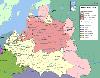
| Lublin Voivodeship FeatureType : adm1st Elevation : 172 Lat/Lng : 51.2228 / 22.9028 | Lublin Voivodeship, or Lublin ProvinceArkadiusz Belczyk, , 2002-2006. (in Polish, województwo lubelskie), is a voivodeship, or province, located in southeastern Poland. It was created on January 1, 1999, out of the former Lublin, Chełm, Zamość, Biała Podlaska and (partially) Tarnobrzeg and Siedlce (...) |
| 12 | 
| Poland FeatureType : country Elevation : 110 Lat/Lng : 52.2323 / 21.0084 | Poland , officially the Republic of Poland , is a country located in Central Europe. It is divided into 16 administrative subdivisions, covering an area of , and has a largely temperate seasonal climate. With a population of approximately 38 (...) |
| 13 | 
| Rēzekne FeatureType : city Elevation : 157 Lat/Lng : 56.5127 / 27.3427 | Rēzekne (Latgalian Rēzekne or Rēzne , ; see other names) is a city in the Rēzekne River valley in Latgale region of eastern Latvia. It is called The Heart of Latgale (Latvian Latgales sirds, Latgalian Latgolys sirds) (...) |
| 14 | 
| Druskininkai FeatureType : city Elevation : 94 Lat/Lng : 54.0206 / 23.9725 | Druskininkai (Druzgenik) is a spa town on the Nemunas River in southern Lithuania, close to the borders of Belarus and Poland. The city of Druskininkai has a population of 23136 (2015 Census) and dates back as a spa resort to the 19th century. (...) |
| 15 | 
| Moscow Belorussky railway station FeatureType : railwaystation Elevation : 153 Lat/Lng : 55.7765 / 37.5802 | Belorussky railway terminal is a passenger terminal at the Moscow–Passenger–Smolenskaya railway station (also known as Moskva-Smolenskaya) of the Moscow Railway. Informally the whole station can be called as Moscow Belorusskaya (Moskva Belorusskaya). It is one of nine railway terminals of Moscow (...) |
| 16 | 
| Ternopil FeatureType : null Elevation : 303 Lat/Lng : 49.55 / 25.58 | Ternopil is a city in western Ukraine, located on the banks of the Seret River. Until 1944, it was known mostly as Tarnopol. Ternopil is one of the major cities of Western Ukraine and the historical regions of Galicia and Podolia. It is served by Ternopil Airport (...) |
| 17 | 
| Chełm FeatureType : city Elevation : 220 Lat/Lng : 51.1322 / 23.4778 | Chełm is a city in eastern Poland with 63,949 inhabitants (2015). It is located to the south-east of Lublin, north of Zamość and south of Biała Podlaska, some from the border with Ukraine. Chełm used to be the capital of the Chełm Voivodeship until it became part of the Lublin Voivodeship in 1999 (...) |
| 18 | Duchy of Warsaw FeatureType : null Elevation : 116 Lat/Lng : 52.2333 / 21.0167 | The Duchy of Warsaw was a Polish state established by Napoleon I in 1807 from the Polish lands ceded by the Kingdom of Prussia under the terms of the Treaties of Tilsit. The duchy was held in personal union by one of Napoleon's allies, King Frederick Augustus I of Saxony (...) | |
| 19 | 
| Gdańsk FeatureType : null Elevation : 7 Lat/Lng : 54.352 / 18.6466 | Gdańsk is a Polish city on the Baltic coast. It is the capital of the Pomeranian Voivodeship and the capital of Kashubia, Poland's principal seaport and the centre of the country's fourth-largest metropolitan area (...) |
| 20 | 
| Vilnius FeatureType : city Elevation : 106 Lat/Lng : 54.6883 / 25.2714 | Vilnius (see also other names) is the capital of Lithuania and its largest city, with a population of 574,147 . Vilnius is in the southeast part of Lithuania and is the second largest city in the Baltic states. Vilnius is the seat of the main government institutions of Lithuania and the Vilnius (...) |
| 21 | 
| Katyn massacre FeatureType : event Elevation : 193 Lat/Lng : 54.7722 / 31.79 | The Katyn massacre ("Katyń crime"; Katynskaya reznya, "Katyn massacre", or , "Katyn execution by shooting") was a series of mass executions of Polish officers and intelligentsia carried out by the Soviet Union, specifically the NKVD ("People's Commissariat for Internal Affairs", aka the Soviet (...) |
| 22 | 
| Latvia FeatureType : null Elevation : 0 Lat/Lng : 56.95 / 24.1 | Latvia (or ;), officially the Republic of Latvia , is a country in the Baltic region of Northern Europe. Since its independence, Latvia has been referred to as one of the Baltic states. It is bordered by Estonia in the northern region, Lithuania in the southern, to the east is Russia, and Belarus to (...) |
| 23 | 
| Riga FeatureType : null Elevation : 15 Lat/Lng : 56.9489 / 24.1064 | Riga is the capital and largest city of Latvia. With 641,481 inhabitants (2016), it is also the largest city in the three Baltic states, home to one third of Latvia's population and one tenth of the three Baltic states' combined population (...) |
| 24 | 
| Mykolaiv FeatureType : city Elevation : 22 Lat/Lng : 46.9667 / 31.9908 | Mykolaiv , also known as Nikolaev or Nikolayev , is a city in southern Ukraine, the administrative center of the Mykolaiv Oblast. Mykolaiv is arguably the main shipbuilding center of the Black Sea. Aside from three shipyards within the city, there are a number of research centers specializing in (...) |
| 25 | 
| Odessa FeatureType : city Elevation : 38 Lat/Lng : 46.4857 / 30.7434 | Odessa (also known as Odesa; ; ;) is the third most populous city of Ukraine and a major tourism center, seaport and transportation hub located on the northwestern shore of the Black Sea. It is also the administrative center of the Odessa Oblast and a multiethnic cultural center (...) |
| 26 | 
| Lviv FeatureType : null Elevation : 307 Lat/Lng : 49.83 / 24.0142 | Lviv (; ' ; ; ; ; see also other names) is the largest city in western Ukraine and the seventh-largest city in the country overall, with a population of around 728,350 as of 2016. Lviv is one of the main cultural centres of Ukraine (...) |
| 27 | 
| Sejny FeatureType : city Elevation : 133 Lat/Lng : 54.1067 / 23.3486 | Sejny is a town in north-eastern Poland and the capital of Sejny County, in Podlaskie Voivodeship, close to the northern border with Lithuania and Belarus. It is located in the eastern part of the Suwałki Lake Area , on the Marycha river (Seina in Lithuanian for which the town was named), being a (...) |
| 28 | 
| Lithuania FeatureType : country Elevation : 137 Lat/Lng : 54.6833 / 25.2667 | Lithuania , officially the Republic of Lithuania , is a country in the Baltic region of northern-eastern Europe. Since its independence, Lithuania has been referred to as one of the Baltic states. It is situated along the southeastern shore of the Baltic Sea, to the east of Sweden and Denmark (...) |
| 29 | 
| Kaunas FeatureType : city Elevation : 33 Lat/Lng : 54.8972 / 23.8861 | Kaunas (; ; also see other names) is the second-largest city in Lithuania and the historical centre of Lithuanian economic, academic, and cultural life. Kaunas was the biggest city and the centre of a county in Trakai Municipality of the Grand Duchy of Lithuania since 1413 (...) |
| 30 | 
| Russia FeatureType : country Elevation : 157 Lat/Lng : 55.75 / 37.6167 | Russia , officially the Russian Federation"The names Russian Federation and Russia shall be equal". , is a country in Eurasia. At , Russia is the largest country in the world by area, covering more than one-eighth of the Earth's inhabited land area, and the ninth most populous, with about 144 (...) |
| 31 | 
| Tricity, Poland FeatureType : null Elevation : 99 Lat/Lng : 54.4333 / 18.55 | Tricity, or Tri-City is a metropolitan area in Poland consisting of three cities in Pomerania: Gdańsk, Gdynia and Sopot, as well as minor towns in their vicinity. They are situated adjacent to one other, in a row on the coast of Gdańsk Bay, Baltic Sea, in Pomerelia (Pomeranian Voivodeship), northern (...) |
| 32 | 
| Sweden FeatureType : country Lat/Lng : 63.0 / 16.0 | Sweden , officially the Kingdom of Sweden (Swedish: Konungariket Sverige), is a Scandinavian Nordic country in Northern Europe. It borders Norway to the west and north and Finland to the east, and is connected to Denmark in the southwest by a bridge-tunnel across the Öresund, a strait at the (...) |
| 33 | 
| Czech Republic FeatureType : country Elevation : 324 Lat/Lng : 49.85 / 15.4667 | The Czech Republic , also known by its short-form name, Czechia , is a landlocked country in Central Europe bordered by Germany to the west, Austria to the south, Slovakia to the east and Poland to the northeast (...) |
| 34 | Terespol FeatureType : null Elevation : 132 Lat/Lng : 52.0733 / 23.6086 | Terespol is a town in eastern Poland on the border with Belarus. It lies on the border river Bug, directly opposite the city of Brest, Belarus. It has 6,002 inhabitants (2004). (...) | |
| 35 | 
| Chortkiv FeatureType : null Elevation : 231 Lat/Lng : 49.0183 / 25.7972 | Chortkiv (; ; Chortkov) is a city in Ternopil Oblast (province) in western Ukraine. It is the administrative center of the Chortkiv Raion (district), housing the district's local administration buildings. Chortkiv is located in the northern part of the historic region of Galician Podolia on the (...) |
| 36 | Luninets FeatureType : city Elevation : 136 Lat/Lng : 52.25 / 26.8 | Luninets (D.E. Rosental, Slovar' udarenii dlya rabotnikov radio i televideniya (Moscow, 1984), p. 640. , , BGN/PCGN romanization: Luninyets) is a town and administrative centre for the Luninets district in Brest Province, Belarus, before which it was in Poland (1540–1793, 1920–1939) and Russia and (...) | |
| 37 | Battle of Warsaw (1920) FeatureType : event Elevation : 86 Lat/Lng : 52.3 / 20.8167 | The Battle of Warsaw refers to the decisive Polish victory in 1920 during the Polish–Soviet War. Poland, on the verge of total defeat, repulsed and defeated the invading Red Army. As Soviet forces invaded Poland in summer 1920, the Polish army retreated westward in disarray (...) | |
| 38 | Międzyrzec Podlaski FeatureType : city Elevation : 146 Lat/Lng : 51.9833 / 22.7833 | Międzyrzec Podlaski is a city in Biała Podlaska County, Lublin Voivodeship, Poland, with the population of 17,162 inhabitants . The total area of the city is . Międzyrzec is located near the Krzna river, not far from the border with Belarus. (...) | |
| 39 | Zhabinka FeatureType : city Elevation : 140 Lat/Lng : 52.2006 / 24.0233 | Zhabinka (; ; Zhabinke) it's a city in the southwestern region of Brest, Belarus. It is the administrative center of the Zhabinka District. The population is 12,900. (...) | |
| 40 | Mińsk Mazowiecki FeatureType : city Elevation : 150 Lat/Lng : 52.1833 / 21.5667 | Mińsk Mazowiecki "Masovian Minsk" is a town in central Poland with 40,211 inhabitants (2015). It is situated in the Masovian Voivodeship (since 1999), previously in Siedlce Voivodeship (1975–1998). It is the capital of Mińsk County. (...) | |
| 41 | 
| Geography of Poland FeatureType : country Elevation : 110 Lat/Lng : 52.0 / 20.0 | Poland is a country in East-Central Europe with an area of 312,679 square kilometres (120,726 sq. mi.), and mostly temperate climate. Central Statistical Office (Poland). 28 July 2008. Generally speaking, Poland is an almost unbroken plain reaching from the Baltic Sea in the north, to the Carpathian (...) |
| 42 | National road 2 (Poland) FeatureType : landmark Elevation : 159 Lat/Lng : 52.146 / 22.2259 | National road 2 is part of the Polish national road network. The highway connects the western and eastern regions of Poland, running from Świecko at the German border to Terespol at the border with Belarus, traversing through the Lubusz, Greater Poland, Łódź Masovian and Lublin voivodeships (...) | |
| 43 | Hantsavichy FeatureType : city Elevation : 162 Lat/Lng : 52.7617 / 26.4278 | Hantsavichy is a city in the Brest Region of Belarus, an administrative center of the Hantsavichy District. There is a Volga-type radar near Hantsavichy Radar Station which is a part of the Russian early warning radar system (until 2020). (...) | |
| 44 | Bielsk Podlaski FeatureType : null Elevation : 137 Lat/Lng : 52.7667 / 23.2 | Bielsk Podlaski is an Urban Gmina (Polish: gmina miejska) (Town) in Bielsk County, Podlaskie Voivodeship. It is located north-eastern Poland, in the historical region of Podlachia. (...) | |
| 45 | Byelorussian Soviet Socialist Republic FeatureType : null Elevation : 222 Lat/Lng : 53.9 / 27.5667 | The Byelorussian Soviet Socialist Republic (BSSR, or Byelorussian SSR; ;), also commonly referred to in English as Byelorussia, was a federal unit of the Soviet Union (USSR). It existed between 1920 and 1922, and from 1922 to 1991 as one of fifteen constituent republics of the USSR, with its own (...) | |
| 46 | Vistula FeatureType : null Lat/Lng : 54.3617 / 18.9519 | The Vistula is the longest and largest river in Poland and the 9th longest river in Europe, at in length. The drainage basin area of the Vistula is , of which lies within Poland (54% of its land area)., Statistics Poland, p. 85-86 The remainder is in Belarus, Ukraine and Slovakia (...) | |
| 47 | Grójec FeatureType : city Elevation : 154 Lat/Lng : 51.8656 / 20.8675 | Grójec is a town in Poland. Located in the Masovian Voivodeship, about south of Warsaw. It is the capital of urban-rural gmina Grójec and Grójec County. It has 16,674 inhabitants (2017). Grójec surroundings are considered to be the biggest apple-growing area of Poland (...) | |
| 48 | Congress Poland FeatureType : null Elevation : 116 Lat/Lng : 52.2333 / 21.0167 | The Kingdom of Poland, ; , Tsarstvo Polskoye, , , translation: Tsardom of Poland informally known as Congress Poland ; or Russian Poland, was created in 1815 by the Congress of Vienna as a sovereign state of the Russian partition of Poland (...) | |
| 49 | Białystok FeatureType : null Elevation : 147 Lat/Lng : 53.1353 / 23.1456 | Białystok is the largest city in northeastern Poland and the capital of the Podlaskie Voivodeship. Located in the Białystok Uplands of the Podlaskie Plain on the banks of the Biała River, Białystok ranks second in terms of population density, tenth in population, and thirteenth in area, of the (...) | |
| 50 | Zhodzina FeatureType : city Elevation : 164 Lat/Lng : 54.1 / 28.35 | Zhodzina (officially transliterated as Žodzina,Instruction on transliteration of Belarusian geographical names with letters of Latin script also spelled Zhodino), is a city in Belarus, located in the Minsk Region, 50 km to north-east from Minsk (...) | |
| 51 | Second Polish Republic FeatureType : country Elevation : 114 Lat/Lng : 52.2167 / 21.0 | The Second Polish Republic, commonly known as interwar Poland, refers to the country of Poland in the period between the First and Second World Wars (1918–1939). Officially known as the Republic of Poland , the Polish state was re-established in 1918, in the aftermath of World War I (...) | |
| 52 | Vawkavysk FeatureType : city Elevation : 195 Lat/Lng : 53.1422 / 24.4475 | Vawkavysk is one of the oldest towns in southwestern Belarus and the capital of the Vawkavysk district. It is located on the Wołkowyja River, roughly from Grodno and from Minsk. Its population is estimated at 43,826 inhabitants (...) | |
| 53 | Eastern Europe FeatureType : null Elevation : 202 Lat/Lng : 50.0 / 30.0 | Eastern Europe is the eastern part of the European continent. There is no consensus on the precise area it covers, partly because the term has a wide range of geopolitical, geographical, cultural, and socioeconomic connotations (...) | |
| 54 | Gmina Brańsk FeatureType : null Elevation : 131 Lat/Lng : 52.75 / 22.8333 | __NOTOC__ Gmina Brańsk is a rural gmina (Polish:gmina wiejska) in Bielsk County, Podlaskie Voivodeship. It is located in north-eastern Poland. (...) | |
| 55 | Kapyl FeatureType : null Elevation : 220 Lat/Lng : 53.1516 / 27.0913 | Kapyl is an urban settlement and the capital of Kapyl Raion in Belarus. It is located west-northwest of Slutsk and south-southwest of Minsk., Kapyl, Belarus on JewishGen.Org accessed 13 July 2010 The current population estimate of 9,900 for the town is based on the provisional figures from the 2009 (...) | |
| 56 | Polish–Lithuanian Commonwealth FeatureType : country Elevation : 220 Lat/Lng : 50.0614 / 19.9383 | The Polish–Lithuanian Commonwealth, formally the Crown of the Kingdom of Poland and the Grand Duchy of Lithuania, after 1791 the Commonwealth of Poland, was a dualistic state, a bi-confederation of Poland and Lithuania ruled by a common monarch, who was both the King of Poland and the Grand Duke of (...) | |
| 57 | Czeremcha, Podlaskie Voivodeship FeatureType : city Elevation : 177 Lat/Lng : 52.5186 / 23.3481 | Czeremcha (Cheremkha) is a village in Hajnówka County, Podlaskie Voivodeship, in north-eastern Poland, close to the border with Belarus. It is the seat of the gmina (administrative district) called Gmina Czeremcha (...) | |
| 58 | Gmina Boćki FeatureType : null Elevation : 143 Lat/Lng : 52.65 / 23.0333 | __NOTOC__ Gmina Boćki is a rural gmina (Polish:gmina wiejska) in Bielsk County, Podlaskie Voivodeship. It is located north-eastern Poland. (...) | |
| 59 | Alytus FeatureType : city Elevation : 105 Lat/Lng : 54.4 / 24.0333 | Alytus is a city with municipal rights in southern Lithuania. It is the capital of Alytus County. Its population in 2013 was 57,281. Alytus is the historical centre of the Dzūkija region. The city lies on the banks of the Nemunas River (...) | |
| 60 | Daugavpils FeatureType : null Elevation : 96 Lat/Lng : 55.8689 / 26.5347 | Daugavpils (; ; ; ; see other names) is a city in southeastern Latvia, located on the banks of the Daugava River, from which the city gets its name. It is the second largest city in the country after the capital Riga, which is located some to its north-west (...) | |
| 61 | Puławy FeatureType : null Elevation : 137 Lat/Lng : 51.4164 / 21.9692 | Puławy is a city in eastern Poland, in Lublin Province of northern Lesser Poland, located at the confluence of the Wisła and Kurówka rivers. According to the GUS census estimate, the city had a total population of 49,839 in 2006 (...) | |
| 62 | Byaroza FeatureType : city Elevation : 150 Lat/Lng : 52.5314 / 24.9786 | Biaroza (official Belarusian romanization standard: Biaroza, formerly Бяро́за-Карту́зская; ;) is a town of 31 000 inhabitants (1995) in Western Belarus in Brest Region and the administrative center of the Byaroza District. (...) | |
| 63 | Katyn (rural locality) FeatureType : city Elevation : 179 Lat/Lng : 54.7701 / 31.6898 | Katyn is a rural locality (a selo) in Smolensky District of Smolensk Oblast, Russia, located approximately to the west of Smolensk, the administrative center of the oblast. (...) | |
| 64 | Soviet invasion of Poland FeatureType : country Elevation : 102 Lat/Lng : 52.1469 / 19.3781 | The Soviet invasion of Poland was a military operation by the Soviet Union without a formal declaration of war. On 17 September 1939, the Soviet Union invaded Poland from the east, sixteen days after Germany invaded Poland from the west (...) | |
| 65 | Vileyka FeatureType : null Elevation : 151 Lat/Lng : 54.498 / 26.926 | Vileyka (officially transliterated as Viliejka, , also Вялейка; ; ;) is a city in Belarus and the administrative center of the Vileyka Raion in the Minsk Region. It is located on the River Viliya, 100 km northwest of Minsk. The first documentary record dates from 16 November 1460 (...) | |
| 66 | Białystok railway station FeatureType : railwaystation Elevation : 134 Lat/Lng : 53.1344 / 23.1356 | Białystok railway station is the most important railway station in the city of Białystok, Poland. It is sometimes referred to as Białystok Central (Białystok Centralny), to distinguish it from six other, much smaller, stations located in the city. (...) | |
| 67 | Mielnik FeatureType : city Elevation : 144 Lat/Lng : 52.33 / 23.0486 | Mielnik is a village in Siemiatycze County, Podlaskie Voivodeship, in north-eastern Poland, close to the border with Belarus. It is the seat of the gmina (administrative district) called Gmina Mielnik. It lies approximately south-east of Siemiatycze and south of the regional capital Białystok (...) | |
| 68 | Gmina Wyszki FeatureType : null Elevation : 153 Lat/Lng : 52.8406 / 22.9749 | __NOTOC__ Gmina Wyszki is a rural gmina (Polish:gmina wiejska) in Bielsk County, Podlaskie Voivodeship. It is located in north-eastern Poland. (...) | |
| 69 | Gmina Orla FeatureType : null Elevation : 146 Lat/Lng : 52.7072 / 23.33 | __NOTOC__ Gmina Orla is a rural gmina in Bielsk County, Podlaskie Voivodeship. It is located in north-eastern Poland. It is one of five Polish/Belarusian bilingual Gmina in Podlaskie Voivodeship regulated by the Act of 6 January 2005 on National and Ethnic Minorities and on the Regional Languages, (...) | |
| 70 | Kazimir Malevich FeatureType : null Elevation : 183 Lat/Lng : 55.7213 / 37.338 | Kazimir Severinovich Malevich (// ЦГИАК Украины, ф. 1268, оп. 1, д. 26, л. 13об—14. – May 15, 1935) was a Russian avant-garde artist and art theorist, whose pioneering work and writing had a profound influence on the development of non-objective, or abstract art, in the 20th century (...) | |
| 71 | 2018–19 UEFA Champions League FeatureType : null Elevation : 13 Lat/Lng : 51.1933 / 3.1806 | The 2018–19 UEFA Champions League is the 64th season of Europe's premier club football tournament organised by UEFA, and the 27th season since it was renamed from the European Champion Clubs' Cup to the UEFA Champions League. The final will be played at the Wanda Metropolitano in Madrid, Spain (...) | |
| 72 | Brańsk FeatureType : city Elevation : 124 Lat/Lng : 52.7333 / 22.85 | Brańsk is an Urban Gmina (Polish: gmina miejska) (Town) in Bielsk County, Podlaskie Voivodeship. It is located north-eastern Poland. (...) | |
| 73 | Battle of Tannenberg FeatureType : event Elevation : 201 Lat/Lng : 53.4958 / 20.1344 | The Battle of Tannenberg was fought between Russia and Germany between the 26th and 30th of August 1914, the first month of World War I. The battle resulted in the almost complete destruction of the Russian Second Army and the suicide of its commanding general, Alexander Samsonov (...) | |
| 74 | Wrocław FeatureType : null Elevation : 118 Lat/Lng : 51.1167 / 17.0333 | Wrocław is a city in western Poland and the largest city in the historical region of Silesia. It lies on the banks of the River Oder in the Silesian Lowlands of Central Europe, roughly 350 kilometres (220 mi) from the Baltic Sea to the north and 40 kilometres (25 mi) from the Sudeten Mountains to (...) | |
| 75 | Soviet Union FeatureType : null Elevation : 157 Lat/Lng : 55.75 / 37.6167 | The Union of Soviet Socialist Republics (USSR), commonly known as the Soviet Union and known outside as Russia, was a socialist state in Eurasia that existed from 30 December 1922 to 26 December 1991.Television documentary from CC&C Ideacom Production,"Apocalypse Never-Ending War 1918-1926", part 2, (...) | |
| 76 | Hlybokaye FeatureType : city Elevation : 159 Lat/Lng : 55.1384 / 27.6905 | Hlybokaye or Glubokoye is a town in Vitebsk Region, Belarus, the capital of Hlybokaye Raion . The city is located on the international road from Polotsk to Vilnius with the historic railway line to Woropajewo completed in 1932 in the interwar Poland (the town was incorporated in 1940 by the Soviet (...) | |
| 77 | Ukrainian People's Republic FeatureType : null Elevation : 159 Lat/Lng : 50.45 / 30.5 | The Ukrainian People's Republic, or Ukrainian National Republic (abbreviated to ,), a predecessor of modern Ukraine, was declared on 10 June 1917 following the February Revolution in Russia. It initially formed part of the Russian Republic, but proclaimed its independence on 25 January 1918 (...) | |
| 78 | Oder–Neisse line FeatureType : null Elevation : 7 Lat/Lng : 53.9263 / 14.224 | The Oder–Neisse line is the international border between Germany and Poland. It was drawn at the Potsdam Conference in the aftermath of the Second World War and is primarily delineated along the Oder and Lusatian Neisse rivers in Central Europe, meeting the Baltic Sea to the north, just west of the (...) | |
| 79 | Ilūkste FeatureType : city Elevation : 98 Lat/Lng : 55.9778 / 26.2975 | Ilūkste (pronunciation; ;) is a town and a seat of Ilūkste Municipality, southeastern Latvia. (...) | |
| 80 | Varėna District Municipality FeatureType : adm2nd Elevation : 123 Lat/Lng : 54.2167 / 24.5667 | Varėna District Municipality is a municipality in Alytus County in southern Lithuania. (...) | |
| 81 | Przemyśl FeatureType : city Elevation : 197 Lat/Lng : 49.7861 / 22.7739 | Przemyśl is a city in south-eastern Poland with 66,756 inhabitants, as of June 2009. In 1999, it became part of the Subcarpathian Voivodeship; it was previously the capital of Przemyśl Voivodeship. Przemyśl owes its long and rich history to the advantages of its geographic location (...) | |
| 82 | Biała Podlaska FeatureType : city Elevation : 142 Lat/Lng : 52.0333 / 23.1167 | Biała Podlaska , is a city in eastern Poland with 58,047 inhabitants (2005). It is situated in the Lublin Voivodeship (since 1999), having previously been the capital of Biała Podlaska Voivodeship (1975–1998). It is the capital of Biała Podlaska County, although the city is not part of the county (...) | |
| 83 | Włocławek FeatureType : city Elevation : 57 Lat/Lng : 52.6592 / 19.0681 | Włocławek is a city located in central Poland along the Vistula (Wisła) River and is bordered by the Gostynińsko-Włocławski Park Krajobrazowy. The population, as of December 2014, is 113,939. Located in the Kuyavian-Pomeranian Voivodeship, it was the capital of Włocławek Voivodeship until 1999. (...) | |
| 84 | Moscow Oblast FeatureType : adm1st Elevation : 208 Lat/Lng : 55.7 / 36.9667 | Moscow Oblast , or Podmoskovye (literally " Moscow"), is a federal subject of Russia (an oblast). With a population of 7,095,120 (2010 Census) living in an area of , it is one of the most densely populated regions in the country and is the second most populous federal subject (...) | |
| 85 | Battle of Grunwald FeatureType : event Elevation : 209 Lat/Lng : 53.4861 / 20.1247 | The Battle of Grunwald, First Battle of Tannenberg or Battle of Žalgiris, was fought on 15 July 1410 during the Polish–Lithuanian–Teutonic War. The alliance of the Kingdom of Poland and the Grand Duchy of Lithuania, led respectively by King Władysław II Jagiełło (Jogaila) and Grand Duke Vytautas, (...) | |
| 86 | Vilnius Voivodeship FeatureType : landmark Elevation : 139 Lat/Lng : 54.6827 / 25.2699 | The Vilnius Voivodeship was one of voivodeships in the Grand Duchy of Lithuania, created in 1413, from the Duchy of Lithuania and neighbouring lands and later incorporated into the newly established Polish-Lithuanian Commonwealth. (...) | |
| 87 | University of Białystok FeatureType : landmark Elevation : 147 Lat/Lng : 53.1278 / 23.1583 | The University of Bialystok is the largest university in the north-eastern region of Poland, educating in various fields of study, including humanities, social and natural sciences and mathematics. It has nine faculties, including a foreign one in Vilnius (...) | |
| 88 | Krynki FeatureType : city Elevation : 158 Lat/Lng : 53.2653 / 23.7719 | Krynki is a town in northeastern Poland, located in Podlaskie Voivodeship along the border with Belarus. Krynki is famous for its history and its old buildings. It lies approximately south-east of Sokółka and east of the regional capital Białystok. (...) | |
| 89 | Nowogródek Voivodeship (1919–1939) FeatureType : adm2nd Elevation : 191 Lat/Lng : 53.0 / 25.0 | Nowogródek Voivodeship was a unit of administrative division of the Second Polish Republic between 1919 and 1939, with the capital in Nowogródek (now Navahrudak, Belarus). Following German and Soviet Invasion of Poland of September 1939, Poland's borders were redrawn in accordance with the (...) | |
| 90 | Augustów Canal FeatureType : waterbody Elevation : 127 Lat/Lng : 53.8667 / 22.9667 | The Augustów Canal is a cross-border canal built in the 19th century in the present-day Podlaskie Voivodeship of northeastern Poland and the Grodno Region of north-western Belarus (then the Augustów Voivodeship of the Kingdom of Poland) (...) | |
| 91 | Choszczno FeatureType : city Elevation : 53 Lat/Lng : 53.1692 / 15.4194 | Choszczno is a town (population around 16,173) in West Pomeranian Voivodeship, Poland. The town is in a marshy district between the river Stobnica and Klukom lake, southwest of Stargard Szczeciński and on the main railway line between Szczecin and Poznań (...) | |
| 92 | October 1 FeatureType : null Elevation : -3 Lat/Lng : 45.2 / 36.6 | It is the first day of the fourth quarter of the year. (...) | |
| 93 | Khmelnytsky Uprising FeatureType : null Elevation : 71 Lat/Lng : 49.0833 / 32.6666 | The Khmelnytsky Uprising (; ; ; ; also known as the Cossack-Polish War, the Chmielnicki Uprising, or the Khmelnytsky insurrection Britannica.) was a Cossack rebellion within the Polish-Lithuanian Commonwealth in 1648–1657, which led to the creation of a Cossack Hetmanate in Ukrainian lands (...) | |
| 94 | Euromaidan FeatureType : null Elevation : 156 Lat/Lng : 50.4506 / 30.5233 | Euromaidan (; , , , literally "Euro Square") was a wave of demonstrations and civil unrest in Ukraine, which began on the night of 21 November 2013 with public protests in Maidan Nezalezhnosti ("Independence Square") in Kiev (...) | |
| 95 | Europe FeatureType : continent Elevation : 112 Lat/Lng : 41.3275 / 19.8186 | Europe is a continent located entirely in the Northern Hemisphere and mostly in the Eastern Hemisphere. It is bordered by the Arctic Ocean to the north, the Atlantic Ocean to the west and the Mediterranean Sea to the south. It comprises the westernmost part of Eurasia (...) | |
| 96 | World War II FeatureType : landmark Elevation : 65 Lat/Lng : 48.7194 / 44.5018 | World War II (often abbreviated to WWII or WW2), also known as the Second World War, was a global war that lasted from 1939 to 1945. The vast majority of the world's countries—including all the great powers—eventually formed two opposing military alliances: the Allies and the Axis (...) | |
| 97 | Vowchyn FeatureType : city Elevation : 137 Lat/Lng : 52.2829 / 23.3106 | Voŭčyn or Volchin is a village in Kamenets Raion, Brest Region, Belarus. It was the birthplace of the last king of Poland, Stanisław August Poniatowski, Wincenty Korwin Gosiewski, and Zygmunt Vogel. (...) | |
| 98 | Białystok Voivodeship (1975–98) FeatureType : null Elevation : 145 Lat/Lng : 53.1333 / 23.15 | See also: Białystok Voivodeship (1919–39) and Białystok Voivodeship Białystok Voivodeship was a unit of administrative division and local government in Poland from 1975 to 1998, when it was superseded by the Podlaskie Voivodeship. Its capital city was Białystok (...) | |
| 99 | Polish Corridor FeatureType : null Elevation : 165 Lat/Lng : 54.35 / 18.3333 | The Polish Corridor , also known as Danzig Corridor, Corridor to the Sea or Gdańsk Corridor, was a territory located in the region of Pomerelia (Pomeranian Voivodeship, eastern Pomerania, formerly part of West Prussia), which provided the Second Republic of Poland (1920–1939) with access to the (...) | |
| 100 | Russian Empire FeatureType : null Lat/Lng : 77.6136 / 103.4533 | The Russian Empire also known as Imperial Russia or simply Russia was an empire that existed across Eurasia and North America from 1721, following the end of the Great Northern War, until the Republic was proclaimed by the Provisional Government that took power after the February Revolution of 1917 (...) | |
| 101 | Sapotskin FeatureType : null Elevation : 148 Lat/Lng : 53.8329 / 23.6598 | Sapotskin is a small town in Belarus, north-west of Hrodna with circa 2,000 inhabitants. (...) | |
| 102 | Battle of Radzymin (1920) FeatureType : event Elevation : 92 Lat/Lng : 52.4167 / 21.1833 | The Battle of Radzymin took place during the Polish–Soviet War (1919–21). The battle occurred near the town of Radzymin, some north-east of Warsaw, between August 13 and 16, 1920. Along with the Battle of Ossów and the Polish counteroffensive from the Wieprz River area, this engagement was a key (...) | |
| 103 | Nazi Germany FeatureType : country Elevation : 33 Lat/Lng : 52.5167 / 13.4 | Nazi Germany is the common English name for Germany between 1933 and 1945, when Adolf Hitler and his Nazi Party (NSDAP) controlled the country through a dictatorship. Under Hitler's rule, Germany was transformed into a totalitarian state that controlled nearly all aspects of life via the (...) | |
| 104 | Wilno Voivodeship (1926–1939) FeatureType : landmark Elevation : 142 Lat/Lng : 54.6805 / 25.2699 | The Wilno Voivodeship was one of 16 Voivodeships in the Second Polish Republic, with the capital in Wilno (now Vilnius, Lithuania). It was created in 1926 and populated predominantly by Poles with notable minorities of Belarusians, Jews and Lithuanians (...) | |
| 105 | Polesie Voivodeship FeatureType : landmark Elevation : 140 Lat/Lng : 52.1182 / 26.0962 | Polesie Voivodeship was an administrative unit of interwar Poland (1918–1939). It was created by the Council of Ministers of the Second Polish Republic on February 19, 1921, as a result of peace agreement signed with the Russian and Ukrainian SSRs in Riga (...) | |
| 106 | Novovolynsk FeatureType : city Elevation : 236 Lat/Lng : 50.7258 / 24.1658 | Novovolynsk is a town of oblast significance in Volyn Oblast, Ukraine. Novovolynsk, together with the urban-type settlement of Blahodatne (until 2016 Zhovtneve), is incorporated as Novovolynsk Municipality, an administrative unit of a status equal to that of a district (...) | |
| 107 | Chernyshevskoye FeatureType : city Elevation : 59 Lat/Lng : 54.6333 / 22.7333 | Chernyshevskoye (; , from 1938: Eydtkau;) is a settlement in Nesterovsky District in the eastern part of Kaliningrad Oblast, Russia, close to the border with Lithuania. Between Chernyshevskoye and Lithuanian Kybartai is an important 24-hour border crossing point on the A229 principal road (part of (...) | |
| 108 | Lithuanian–Byelorussian Soviet Socialist Republic FeatureType : null Elevation : 224 Lat/Lng : 54.0 / 27.0 | The Lithuanian–Byelorussian Soviet Socialist Republic (LBSSR; ; ; ;) or Litbel (Lit-Bel) was a Soviet socialist republic that existed within the territories of modern Belarus and eastern Lithuania for approximately five months during 1919 (...) | |
| 109 | Trawniki concentration camp FeatureType : landmark Elevation : 178 Lat/Lng : 51.1379 / 22.9958 | The Trawniki concentration camp was set up by Nazi Germany in the village of Trawniki about southeast of Lublin during the occupation of Poland in World War II. Throughout its existence the camp served a dual function (...) | |
| 110 | Eišiškės FeatureType : null Elevation : 151 Lat/Lng : 54.1694 / 24.9972 | Eišiškės (/Eishishki, /Eishyshki, /Eyshishok) is a city in southeastern Lithuania on the border with Belarus. It is situated on a small group of hills, surrounded by marshy valley of Verseka and Dumblė Rivers. Rivers divide the town into two parts; the northern part is called Jurzdika (...) | |
| 111 | Drohiczyn FeatureType : city Elevation : 141 Lat/Lng : 52.4 / 22.65 | Drohiczyn is a town in Siemiatycze County, Podlaskie Voivodeship, Poland. The town has a population of 2,110 and is situated on the bank of the Bug River. Drohiczyn has a long and rich history, as in the past it was one of the most important cities of the region of Podlachia (...) | |
| 112 | Opera Nova Bydgoszcz FeatureType : null Elevation : 37 Lat/Lng : 53.1244 / 17.9975 | The Opera Nova is an opera house located in Bydgoszcz and established in 1956, which also plays the role of a musical theater. It is one of the 10 opera houses in Poland and the only one of this size in the Kuyavian-Pomeranian Voivodeship (...) | |
| 113 | Grodno Governorate FeatureType : null Elevation : 128 Lat/Lng : 53.6667 / 23.8167 | The Grodno Governorate, was a governorate (guberniya) of the Russian Empire. It was part of the Vilna Governorate-General and Northwestern Krai. (...) | |
| 114 | Poland–Ukraine border FeatureType : null Elevation : 1035 Lat/Lng : 49.0846 / 22.5578 | Poland–Ukraine border is the state border between Poland and Ukraine. It has a total length of or . Page gives Polish PWN Encyklopedia as reference. (sources vary). (...) | |
| 115 | Shumyachsky District FeatureType : adm2nd Elevation : 212 Lat/Lng : 53.85 / 32.4167 | Shumyachsky District is an administrativeResolution #261 and municipalLaw #138-z district (raion), one of the twenty-five in Smolensk Oblast, Russia. It is located in the southwest of the oblast and borders with Khislavichsky District in the north, Pochinkovsky District in the northwest, Roslavlsky (...) | |
| 116 | Kaunas Airport FeatureType : airport Elevation : 70 Lat/Lng : 54.9639 / 24.0848 | Kaunas International Airport , is the second-busiest civil airport in Lithuania after Vilnius Airport and the fourth-busiest in the Baltic states. The airport is located in the central part of the country, northeast of the Kaunas city centre and 100 km west from the capital Vilnius. (...) | |
| 117 | Innsbruck Hauptbahnhof FeatureType : null Elevation : 584 Lat/Lng : 47.2639 / 11.4009 | Innsbruck Hauptbahnhof (German for Innsbruck Main Station or Central Station at Rail Europe. Accessed on 14 Aug 2013.) is the main railway station in Innsbruck, the capital city of the Austrian federal state of Tyrol. "Upper Austria: Linz Hauptbahnhof, Wels Hauptbahnhof, .. Salzburg Hauptbahnhof, . (...) | |
| 118 | School of Business and Management of Technology of BSU FeatureType : null Elevation : 196 Lat/Lng : 53.8925 / 27.5641 | Officially known as the state educational establishment, the School of Business and Management of Technology of Belarusian State University , SBMT BSU, was established in April 1996. Over 3500 people have graduated from SBMT BSU, with more than 700 acquiring their master's degree or Specialist's (...) | |
| 119 | Švenčionys FeatureType : null Elevation : 199 Lat/Lng : 55.1333 / 26.1556 | Švenčionys (known also by several alternative names) is a town located north of Vilnius in Lithuania. It is the capital of the Švenčionys district municipality. , it had population of 4,963 of which about 17% is part of the Polish minority in Lithuania. (...) | |
| 120 | Gmina Rudka FeatureType : null Elevation : 131 Lat/Lng : 52.7283 / 22.7306 | __NOTOC__ Gmina Rudka is a rural gmina (Polish:gmina wiejska) in Bielsk County, Podlaskie Voivodeship. It is located in north-eastern Poland. (...) | |
| 121 | Bronna Góra FeatureType : city Elevation : 168 Lat/Lng : 52.6107 / 25.0753 | Bronna Góra (or Bronna Mount in English) is the name of a secluded area in present-day Belarus where mass killings of Polish Jews were carried out by Nazi Germany during World War II. The location was part of the eastern half of occupied Poland, which had been invaded by the Soviet Union in 1939 in (...) | |
| 122 | Kodeń FeatureType : city Elevation : 147 Lat/Lng : 51.9103 / 23.6017 | Kodeń is a village in eastern Poland on the Bug River, which forms the border between Poland and Belarus. Administratively, it belongs to Biała Podlaska County in Lublin Voivodeship. It is the seat of the gmina (administrative district) called Gmina Kodeń (...) | |
| 123 | St. John Climacus's Orthodox Church, Warsaw FeatureType : null Elevation : 118 Lat/Lng : 52.228 / 20.9465 | The St. John Climacus's Orthodox Church in Warsaw is an Orthodox parish church belonging to the Warsaw deanery of the diocese of Warsaw-Bielsk within the Polish Orthodox Church. The church is located at 140 Wolska Street in the Ulrychów area of Wola district, inside the Orthodox cemetery (...) | |
| 124 | Mostowski Palace FeatureType : landmark Elevation : 108 Lat/Lng : 52.246 / 20.999 | Mostowski Palace is an 18th-century palace in Warsaw, Poland, located at ul. Nowolipie 2 (2 Nowolipie Street) — prior to World War II, at ul. Przejazd 15. (...) | |
| 125 | Zaolzie FeatureType : null Elevation : 289 Lat/Lng : 49.75 / 18.5 | Zaolzie is the Polish name for an area now in the Czech Republic which was disputed between interwar Poland and Czechoslovakia. The name means "lands beyond the Olza River"; it is also called Śląsk zaolziański, meaning "trans-Olza Silesia" (...) | |
| 126 | 1st Krechowce Uhlan Regiment FeatureType : null Elevation : 207 Lat/Lng : 50.6908 / 26.4186 | The First Krechowce Uhlan Regiment was a mounted unit of the Polish Army, active in the Second Polish Republic. Its traditions were continued during World War II, by a regiment of the same name, which was part of Polish Armed Forces in the West (...) | |
| 127 | Ober Ost FeatureType : null Elevation : 114 Lat/Lng : 52.2331 / 21.02 | is short for , German for "Supreme Commander of All German Forces in the East" during World War I. It also has an implied double meaning, as in its own right, "Ober Ost" translates into "Upper East," which describes its geographic region in reference to the German Empire (...) | |
| 128 | Poland–Russia border FeatureType : null Elevation : 233 Lat/Lng : 54.3634 / 22.792 | The modern Poland–Russia border is a nearly straight-line division between the Republic of Poland (European Union (EU) member) and the Russian Federation (CIS member) exclave of Kaliningrad Oblast. It is currently long (...) | |
| 129 | Liuboml FeatureType : null Elevation : 183 Lat/Lng : 51.2158 / 24.0408 | Liuboml (; , Polish and , Libevne) is a town located in the western part of Ukraine, in the Volyn Oblast (province); close to the border with Poland. It serves as the administrative center of the Lyubomlskyi Raion (district). Population: (...) | |
| 130 | Brześć Ghetto FeatureType : city Elevation : 136 Lat/Lng : 52.1 / 23.7 | The Brześć Ghetto or the Ghetto in Brest on the Bug, also: Brześć nad Bugiem Ghetto, and Brest-Litovsk Ghetto was a World War II Jewish ghetto created by Nazi Germany in occupied Poland in December 1941, six months after the German troops had overrun the Soviet-occupied zone of the Second Polish (...) | |
| 131 | Belarusian State University of Informatics and Radioelectronics FeatureType : edu Elevation : 218 Lat/Lng : 53.9178 / 27.5947 | The Belarusian State University of Informatics and Radioelectronics, also known as BSUIR , is a public Higher Education Institution accredited by the Ministry of Education of the Republic of Belarus. Nowadays it is a large educational and scientific complex in Minsk, Belarus (...) | |
| 132 | Bezirk Bialystok FeatureType : null Elevation : 145 Lat/Lng : 53.1333 / 23.15 | Bezirk Bialystok (German for District of Białystok, also Belostok) was an administrative unit of Nazi Germany created during the World War II invasion of the Soviet Union. It was to the south-east of East Prussia, in present-day northeastern Poland as well as in smaller sections of adjacent (...) | |
| 133 | Poznan University of Medical Sciences FeatureType : null Elevation : 79 Lat/Lng : 52.4094 / 16.9189 | Poznan University of Medical Sciences is a prominent Polish medical university, located in the city of Poznań in western Poland. It traces its beginnings to the foundation of Poznań University in 1919, and was formed as a separate institution in 1950. It gained the status of uniwersytet in 2007. (...) | |
| 134 | Congregation of Saint Michael the Archangel FeatureType : null Elevation : 86 Lat/Lng : 52.3617 / 21.1376 | The Congregation of Saint Michael the Archangel (CSMA) Congregatio Sancti Michaëlis Archangeli), also known as the Michaelite Fathers, is a religious institute of the Roman Catholic Church founded in 1897 by the Blessed Father Bronisław Markiewicz, a Polish priest from Miejsce Piastowe, Poland (...) | |
| 135 | Central station FeatureType : null Elevation : 519 Lat/Lng : 48.1405 / 11.5529 | Central stations or central railway stations emerged in the second half of the nineteenth century as railway stations that had initially been built on the edge of city centres were enveloped by urban expansion and became an integral part of the city centres themselves.Kellerman, Aharon (...) | |
| 136 | Vilnius Region FeatureType : adm1st Elevation : 194 Lat/Lng : 54.5 / 25.4167 | Vilnius Region (also formerly known in English: as Wilno Region or Vilna Region) is the territory in the present-day Lithuania and Belarus that was originally inhabited by ethnic Baltic tribes and was a part of Lithuania proper, but came under East Slavic and Polish cultural influences over time (...) | |
| 137 | Vasyl Stefanyk Precarpathian National University FeatureType : null Elevation : 258 Lat/Lng : 48.9152 / 24.7012 | Vasyl Stefanyk Precarpathian National University is one of the oldest institutions of higher education in Western Ukraine. Its history dates back to March 15, 1940, when Stanislav Teacher Training Institute was established (...) | |
| 138 | UEFA Euro 2020 bids FeatureType : null Elevation : 973 Lat/Lng : 40.1804 / 44.495 | The bidding process for the UEFA Euro 2020 is the process by which the location for the 16th European Championship, commonly referred to as Euro 2020, was selected. The process officially began on 21 March 2012 with the intent to announce the hosts in late 2013 or early 2014 (...) | |
| 139 | Anastasy Vonsiatsky FeatureType : null Elevation : 103 Lat/Lng : 41.9475 / -71.8864 | Anastasy Andreyevich Vonsyatsky (; June 12, 1898 – February 5, 1965), better known in the United States as Anastase Andreivitch Vonsiatsky, was a Russian anti-Bolshevik émigré and fascist leader based in the United States from the 1920s (...) | |
| 140 | Russian military intervention in Ukraine (2014–present) FeatureType : null Elevation : 159 Lat/Lng : 50.45 / 30.5 | In February 2014, Russia made several military incursions into Ukrainian territory. After Euromaidan protests and the fall of Ukrainian president Viktor Yanukovych, Russian soldiers without insignias took control of strategic positions and infrastructure within the Ukrainian territory of Crimea (...) | |
| 141 | Bzów FeatureType : city Elevation : 161 Lat/Lng : 52.1144 / 22.4714 | Bzów is a village in the administrative district of Gmina Zbuczyn, within Siedlce County, Masovian Voivodeship, in east-central Poland. It lies approximately north-east of Zbuczyn, east of Siedlce, and east of Warsaw (...) | |
| 142 | Lyady, Vitebsk Region FeatureType : city Elevation : 179 Lat/Lng : 54.6011 / 31.1713 | Lyady is a hamlet in the Dubrovna District of Vitebsk Region, Belarus adjacent to the Belarus–Russia border. (...) | |
| 143 | Słonim Ghetto FeatureType : null Elevation : 180 Lat/Lng : 53.0443 / 25.1904 | The Słonim Ghetto was a Jewish World War II ghetto established in 1941 by the Schutzstaffel (SS) in the prewar Polish city of Słonim located in the eastern region of Kresy (now Slonim, Belarus), occupied by Germany after the launch of Operation Barbarossa (...) | |
| 144 | Bolzano/Bozen railway station FeatureType : railwaystation Elevation : 270 Lat/Lng : 46.4966 / 11.3584 | Bolzano/Bozen railway station is the main station of Bolzano/Bozen, capital of the autonomous province of Alto Adige/Südtirol, in northeastern Italy. The station was opened in 1859 by the Austrian Empire's Südbahn (...) | |
| 145 | Polish Golden Age FeatureType : country Elevation : 198 Lat/Lng : 50.05 / 19.9333 | The Polish Golden Age refers to the period from the late 15th century Jagiellon Poland to the death of the last of the Jagiellons, Sigismund August in 1572. Some historians claim that the Golden Age lasted until the mid-17th century, when in 1648 the Polish-Lithuanian Commonwealth was ravaged by the (...) | |
| 146 | Jedwabne pogrom FeatureType : landmark Elevation : 173 Lat/Lng : 53.2888 / 22.3096 | The Jedwabne pogrom was a World War II massacre committed on 10 July 1941 in the town of Jedwabne, in German-occupied Poland. At least 340 Polish Jews, including women and children, were murdered,P.A.I.C., Polish Academic Information Center, University of Buffalo, 2000 (...) | |
| 147 | Kalininets FeatureType : null Elevation : 207 Lat/Lng : 55.5585 / 36.9749 | Kalininets is a town in the Naro-Fominsky District in Moscow Oblast, Russia. The town is named after Mikhail Ivanovich Kalinin (Russian: Михаи́л Ива́нович Кали́нин). (...) | |
| 148 | Verona Porta Nuova railway station FeatureType : railwaystation Elevation : 64 Lat/Lng : 45.4292 / 10.9822 | Verona Porta Nuova is the main railway station of Verona. It is one of the two stations serving central Verona; the other station, Verona Porta Vescovo, is located at the east of the city. It is situated at Piazzale XXV Aprile ("25 April") at the south of the city centre (...) | |
| 149 | Kesher Israel (Washington, D.C.) FeatureType : null Elevation : 22 Lat/Lng : 38.9069 / -77.0571 | Kesher Israel (Hebrew: קשר ישראל, "Kinship of Israel," also known as the Georgetown Synagogue) is a Modern Orthodox synagogue located in the Georgetown neighborhood of Washington, D.C.. The congregation is over 100 years old and its worshipers have included prominent politicians, diplomats, jurists, (...) | |
| 150 | Lipka Tatars FeatureType : null Elevation : 148 Lat/Lng : 54.6333 / 24.9333 | The Lipka Tatars (also known as Lithuanian Tatars, Polish Tatars, Lipkowie, Lipcani or Muślimi) are a group of Tatars who originally settled in the Grand Duchy of Lithuania at the beginning of the 14th century. The first settlers tried to preserve their shamanistic religion and sought asylum amongst (...) | |
| 151 | Kiev Offensive (1920) FeatureType : event Elevation : 194 Lat/Lng : 50.45 / 30.5167 | The 1920 Kiev Offensive (or Kiev Operation), sometimes considered to have started the Soviet-Polish War, was an attempt by the armed forces of the newly re-emerged Poland led by Józef Piłsudski, in alliance with the Ukrainian leader Symon Petliura, to seize the territories of modern-day Ukraine (...) | |
| 152 | Battle of the Niemen River FeatureType : null Elevation : 133 Lat/Lng : 53.5 / 24.0 | The Battle of the Niemen River was the second-greatest battle of the Polish–Soviet War. It took place near the middle Neman River between the cities of Suwałki, Grodno and Białystok. After having suffered almost complete defeat in the Battle of Warsaw (August 1920), Mikhail Tukhachevski's Red Army (...) | |
| 153 | History of Wrocław FeatureType : null Elevation : 121 Lat/Lng : 51.1069 / 17.077 | Wrocław has long been the largest and culturally dominant city in Silesia, and is today the capital of Poland's Lower Silesian Voivodeship. The history of Wrocław starts at a crossroads in Lower Silesia. It was one of the centres of the Duchy and then Kingdom of Poland, and briefly, in the first (...) | |
| 154 | Solar eclipse of August 1, 2008 FeatureType : null Lat/Lng : 65.6467 / 72.2567 | A total solar eclipse occurred on August 1, 2008. A solar eclipse occurs when the Moon passes between Earth and the Sun, thereby totally or partly obscuring the image of the Sun for a viewer on Earth. A total solar eclipse occurs when the Moon's apparent diameter is larger than the Sun's, blocking (...) | |
| 155 | World Youth Day 2016 FeatureType : null Elevation : 193 Lat/Lng : 50.0309 / 20.0934 | World Youth Day 2016 (WYD 2016) was an international Catholic event focused on faith and youth, that took place from 26 to 31 July 2016 in Kraków, Poland, organised by the Catholic Church. It was the third World Youth Day held in Central Europe (...) | |
| 156 | American Jewish Joint Distribution Committee FeatureType : null Elevation : 17 Lat/Lng : 40.7522 / -73.9729 | The American Jewish Joint Distribution Committee, also known as the Joint or the JDC, is a Jewish relief organization based in New York City. (...) | |
| 157 | Zdzięcioł Ghetto FeatureType : city Elevation : 175 Lat/Lng : 53.45 / 25.4 | The Zdzięcioł Ghetto, Dzyatlava Ghetto or Zhetel Ghetto (in Yiddish) was a Jewish ghetto established by Nazi Germany in the town of Zdzięcioł in the occupied eastern part of the Republic of Poland (now Dziatłava, Belarus) during Holocaust in World War II (...) | |
| 158 | Embassy of Canada to Poland FeatureType : landmark Elevation : 111 Lat/Lng : 52.2247 / 21.0261 | The Embassy of Canada to Poland (French: Ambassade du Canada en Pologne; Polish: Ambasada Kanady w Polsce) in Warsaw is the diplomatic mission of Canada to Poland. The Embassy also covers the country of Belarus as part of its mandate (...) | |
| 159 | Józef Piłsudski Institute of America FeatureType : null Elevation : 14 Lat/Lng : 40.7299 / -73.955 | The Józef Piłsudski Institute of America (full name: Józef Piłsudski Institute of America for Research in the Modern History of Poland) was created in New York in July 1943. It is an archive, museum and research center devoted to the study of modern Polish history and named after the Polish interwar (...) | |
| 160 | Shizuoka University FeatureType : edu Elevation : 48 Lat/Lng : 34.9658 / 138.431 | is a national university in Shizuoka Prefecture, Japan. Shizuoka University is well known in the field of engineering, in creative innovation, and in the invention of next generation technology, with the prestigious international exchange of laboratories in these fields.http://www.eng.shizuoka.ac (...) | |
| 161 | Our Lady of the Gate of Dawn FeatureType : landmark Elevation : 132 Lat/Lng : 54.6743 / 25.2895 | Our Lady of the Gate of Dawn is the prominent Catholic painting of the Blessed Virgin Mary venerated by the faithful in the Chapel of the Gate of Dawn in Vilnius, Lithuania. The painting was historically displayed above the Vilnius city gate; city gates of the time often contained religious (...) | |
| 162 | Gomel Palace FeatureType : city Elevation : 141 Lat/Lng : 52.4222 / 31.0164 | The Rumyantsev-Paskevich Residence is the main place of historical importance in the city of Gomel, Belarus. The grounds of the residence stretch for 800 meters along the steep right bank of the Sozh River. An image of the residence is featured on the Belarusian 20,000-ruble bill (...) | |
| 163 | Kaunas Fortress FeatureType : null Elevation : 25 Lat/Lng : 54.8989 / 23.8854 | Kaunas Fortress is the remains of a fortress complex in Kaunas, Lithuania. It was constructed and renovated between 1882 and 1915 to protect the Russian Empire's western borders, and was designated a "first-class" fortress in 1887 (...) | |
| 164 | Church of the Holy Trinity, Podwale FeatureType : null Elevation : 105 Lat/Lng : 52.2474 / 21.0117 | The Church of the Holy Trinity in Podwale is the oldest historic Orthodox church in Warsaw, located in a building at 5 Podwale Street. Currently, the church parish is part of the Warsaw deanery in the Warsaw-Bielsko diocese of the Polish Orthodox Church and it has a religious center for the Coptic (...) | |
| 165 | History of Poland during the Jagiellonian dynasty FeatureType : country Elevation : 198 Lat/Lng : 50.05 / 19.9333 | The rule of the Jagiellonian dynasty in Poland between 1386 and 1572 spans the late Middle Ages and early Modern Era in European history. The dynasty was founded by the Lithuanian Grand Duke Jogaila (Władysław II Jagiełło), whose marriage to Queen Jadwiga of Poland formed a Polish–Lithuanian union (...) | |
| 166 | Centre for Eastern Studies FeatureType : landmark Elevation : 116 Lat/Lng : 52.2207 / 21.0231 | Centre for Eastern Studies (OSW) is a Warsaw-based think tank that undertakes independent research on the political, economic and social situation in Central and Eastern Europe, Balkans, Caucasus and Central Asia. The Centre was founded in 1990 and is fully financed from the Polish state budget (...) | |
| 167 | Battle of Lesnaya FeatureType : null Elevation : 161 Lat/Lng : 53.55 / 30.9167 | The Battle of Lesnaya (Bitva pri Lesnoy), was one of the major battles of the Great Northern War. It took place on September 28, 1708 (O.S.) / September 29, 1708 (Swedish calendar) / October 9, 1708 (N.S.) between a Russian army of between 26,500 and 29,000 men commanded by Peter I of Russia, (...) | |
| 168 | 2010 Northern Hemisphere heat waves FeatureType : null Elevation : 60 Lat/Lng : 56.3333 / 44.0 | The 2010 Northern Hemisphere summer heat waves included severe heat waves that impacted most of the United States, Kazakhstan, Mongolia, China, Hong Kong, North Africa and the European continent as a whole, along with parts of Canada, Russia, Indochina, South Korea and Japan during May, June, July, (...) | |
| 169 | Ignacy Domeyko FeatureType : city Elevation : 777 Lat/Lng : -28.9542 / -70.8917 | Ignacy Domeyko or Domejko, pseudonym: Żegota (; born near Nieśwież, now Karelichy District, Belarus, 31 July 1802 – 23 January 1889, Santiago de Chile) was a Polish geologist, mineralogist and educator. Domeyko spent most of his life, and died, in his adopted country, Chile (...) | |
| 170 | Mateikonys FeatureType : null Elevation : 152 Lat/Lng : 54.1889 / 25.0111 | Mateikonys is a village in the Šalčininkai district municipality, Lithuania near the border with Belarus. According to the 2011 census it had population of 160. From 1923 to 1939 the village was located in Wilno Voivodeship, north-east Second Polish Republic (...) | |
| 171 | Collegium Da Vinci FeatureType : null Elevation : 61 Lat/Lng : 52.4158 / 16.9313 | Collegium Da Vinci is a Polish private university in Poznan. (...) | |
| 172 | Biosphere reserves of Poland FeatureType : null Elevation : 175 Lat/Lng : 52.6667 / 23.8333 | UNESCO Biosphere Reserves are environment-protected scientific-research institutions of international status that are created with the intent for conservation in a natural state the most typical natural complexes of biosphere, conducting background ecological monitoring, studying of the surrounding (...) | |
| 173 | Battle of Orsha FeatureType : event Elevation : 188 Lat/Lng : 54.5 / 30.3833 | The Battle of Orsha was fought on 8 September 1514, between the allied forces of the Grand Duchy of Lithuania and the Kingdom of Poland, under the command of Hetman Konstanty Ostrogski; and the army of the Grand Duchy of Moscow under Konyushy Ivan Chelyadnin and Kniaz Mikhail Golitsin (...) | |
| 174 | Crown of the Kingdom of Poland FeatureType : null Elevation : 220 Lat/Lng : 50.0614 / 19.9383 | The Crown of the Kingdom of Poland (; Latin: Corona Regni Poloniae), commonly known as the Polish Crown, or, simply, the Crown, is the common name for the historic (but unconsolidated) Late Middle Ages territorial possessions of the King of Poland, including Poland proper (...) | |
| 175 | Battle of Kock (1920) FeatureType : event Elevation : 145 Lat/Lng : 51.65 / 22.45 | The Battle of Kock was fought between August 14 and 16, 1920 in the vicinity of the town of Kock in east-central Poland. The town was to serve as a bridgehead across the Wieprz river for Gen. Józef Piłsudski's counter-offensive against the Russian forces storming Warsaw (...) | |
| 176 | Mount of Olives Jewish Cemetery FeatureType : mountain Elevation : 744 Lat/Lng : 31.7738 / 35.2431 | The Jewish Cemetery on the Mount of Olives, including the Silwan necropolis, is the most ancient and most important cemetery in Jerusalem. Burial on the Mount of Olives started some 3,000 years ago in the First Temple Period, and continues to this day (...) | |
| 177 | Har HaMenuchot FeatureType : mountain Elevation : 730 Lat/Lng : 31.7981 / 35.1777 | Har HaMenuchot (Ashkenazi pronunciation, Har HaMenuchos, lit. "Mount of Those who are Resting", also known as Givat Shaul Cemetery) is the largest cemetery in Jerusalem, Israel. The hilltop burial ground lies at the western edge of the city adjacent to the neighborhood of Givat Shaul, with (...) | |
| 178 | 9th Tank Division (Soviet Union) FeatureType : null Elevation : 157 Lat/Lng : 55.75 / 37.6167 | The 9th Tank Division was the designation of two separate formations of the Soviet Army. The original 9th Tank Division was formed in 1940 and later reorganized into a different division. During World War II, the Soviet Army formed the 9th Tank Corps, which was renamed the 9th Tank Division after (...) | |
| 179 | Bukovinian State Medical University FeatureType : edu Elevation : 252 Lat/Lng : 48.2914 / 25.9322 | Univers Education is our official representative of the University Bukovinian State Medical University (abbreviated as BSMU or БДМУ) is one of the largest higher educational establishment in Chernivtsi. It is a modern multiprofile educational institution of the IV accreditation level, included into (...) | |
| 180 | Janów FeatureType : null Elevation : 215 Lat/Lng : 50.707 / 22.4104 | Janów may refer to: * Janów Lubelski, in the Lublin Voivodship (east Poland) * Janów Poleski, the Polish name for Ivanava, a town in Belarus * Janów-Nikiszowiec, a district of Katowice, a city in Poland * Janów, Chełm County in Lublin Voivodeship (east Poland) * Janów, Lublin County in Lublin (...) | |
| 181 | First Battle of Grodno (1920) FeatureType : event Elevation : 122 Lat/Lng : 53.6667 / 23.8333 | The First Battle of Grodno took place between July 19 and July 20, 1920, during the Polish-Soviet War. In the effect of a three-day-long struggle for the control of the city of Grodno (modern Hrodna, Belarus), the town was captured by Russian forces, despite repeated counter-attacks by Polish (...) | |
| 182 | Jesuit College in Polotsk FeatureType : edu Elevation : 136 Lat/Lng : 55.4861 / 28.7642 | The Jesuit College in Polotsk was a college (equivalent to a secondary school) in Polotsk, Belarus, then part of the Grand Duchy of Lithuania and later Russian Empire. It was established in 1580 and continued to function until 1820 when Jesuits were banished from the Russian Empire. (...) | |
| 183 | National Library of Moldova FeatureType : null Elevation : 57 Lat/Lng : 47.0333 / 28.8333 | The National Library of the Republic of Moldova (BNRM) located in Chişinău, Moldova is the main library of the state which is responsible for conservation, valorization and protection of written cultural heritage (...) | |
| 184 | Battle of Bereza Kartuska FeatureType : null Elevation : 152 Lat/Lng : 52.55 / 24.9667 | The Battle of Bereza Kartuska was fought between the combined forces of the Second Polish Republic and the Soviet Russia around the village Bereza Kartuska (now Byaroza, Belarus) first on 14 February 1919, and again, between July 21 and July 26, 1920 (...) | |
| 185 | Napoleon Bonaparte Monument (Warsaw) FeatureType : null Elevation : 119 Lat/Lng : 52.2344 / 21.0136 | The Napoleon Bonaparte Monument was erected to honor the French military and political leader Napoleon Bonaparte on the 190th anniversary of his death. Napoleon established the Duchy of Warsaw in 1807 from the Polish lands ceded by the Kingdom of Prussia under the terms of the Treaties of Tilsit (...) | |
| 186 | Alfred Nobel University FeatureType : landmark Elevation : 59 Lat/Lng : 48.472 / 35.0427 | Alfred Nobel University, Ukraine is a higher educational institution with the IV level of accreditation. It is committed to enhancing innovative technologies in teaching and it helps to strengthen the country's position in the international arena, which is reflected in its mission (...) | |
| 187 | Vistula University FeatureType : edu Elevation : 97 Lat/Lng : 52.1589 / 21.0342 | Vistula University (VU) (Akademia Finansów i Biznesu Vistula) was founded in 1996 and is one of the first private universities of Poland. Vistula University (Vu) is supervised by the Ministry of Science and Higher Education of The Republic of Poland and accredited by the State Accreditation (...) | |
| 188 | Dnipropetrovsk State University of Internal Affairs FeatureType : null Elevation : 146 Lat/Lng : 48.445 / 35.0528 | The Dnipropetrovsk State University of Internal Affairs (; DDUVS) is a university of the Ministry of Internal Affairs of Ukraine, located in the city of Dnipro. It is a Higher educational institution of the fourth accreditation level. (...) | |
| 189 | Bruno Olbrycht FeatureType : landmark Elevation : 112 Lat/Lng : 52.2519 / 20.9728 | Bruno Olbrycht (nom de guerre: Olza; 6 October 1895 – 23 March 1951) was a soldier of the Austro-Hungarian Army and officer (later general) of the Polish Army both in the Second Polish Republic and postwar Poland (...) | |
| 190 | South African Lipizzaners FeatureType : landmark Elevation : 1476 Lat/Lng : -25.9704 / 28.0548 | The South African Lipizzaners is the name of a riding academy that operates according to the classical model in Kyalami, Midrand (Gauteng), South Africa. In contrast to other classical riding schools, only women ride and train the 40 Lipizzaner stallions (...) | |
| 191 | Battle of Lida (1919) FeatureType : null Elevation : 144 Lat/Lng : 53.8833 / 25.3 | The Battle of Lida took place on 16 and 17 April 1919 around the city of Lida during the Polish–Soviet War of 1919–20. During World War I Lida was occupied by the German troops. In 1919 the Red Army briefly established Soviet power here (...) | |
| 192 | International Association of Students in Agricultural and Related Sciences FeatureType : null Elevation : 32 Lat/Lng : 50.8641 / 4.6865 | The International Association of students in Agricultural and related Sciences (IAAS) is an international non-profit and non-governmental student society headquartered in Leuven, Belgium. It was founded in 1957 in Tunis by 8 countries.iaasworld.org, . Consulted on January 17, 2009 (...) | |
 by
by