| 19 records found in wikipedia | |||
| 1 | 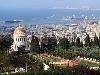
| Haifa  FeatureType : null Elevation : 72 Lat/Lng : 32.8119 / 34.9987 | Haifa is the third-largest city in Israel – after Jerusalem and Tel Aviv– with a population of in . The city of Haifa forms part of the Haifa metropolitan area, the second- or third-most populous metropolitan area in Israel (...) |
| 2 | Ramat Eshkol FeatureType : landmark Elevation : 755 Lat/Lng : 31.8026 / 35.2235 | Ramat Eshkol (also Ramot Eshkol) is an Israeli settlement and neighborhood in East Jerusalem. It was built on land captured from Jordan in the Six-Day War and was the first neighborhood built in East Jerusalem after the Six-Day War in 1967 (...) | |
| 3 | Ramat Eshkol bus bombing FeatureType : null Elevation : 784 Lat/Lng : 31.7987 / 35.2255 | The Ramat Eshkol bus bombing was a Hamas suicide attack on a city bus in the Ramat Eshkol neighborhood of Jerusalem on August 21, 1995. The Palestinian Islamist militant organization Hamas claimed responsibility for the attack. (...) | |
| 4 | 
| Hebron FeatureType : null Elevation : 917 Lat/Lng : 31.524 / 35.103 | Hebron is a Palestinian.... city located in the southern West Bank, south of Jerusalem. Nestled in the Judaean Mountains, it lies 930 meters (3,050 ft) above sea level. The largest city in the West Bank, and the second largest in the Palestinian territories after Gaza, it has a population of 215,452 (...) |
| 5 | Route 417 (Israel) FeatureType : null Elevation : 714 Lat/Lng : 31.7822 / 35.2389 | Route 417 ("Kvish Arba'-Achat-Sheva'") is an intercity road in Israel and the West Bank that stretches from the west side of Jerusalem to Ma'ale Adumim and Highway 1 east to the Jordan Valley. (...) | |
| 6 | Palestinian territories FeatureType : null Elevation : 814 Lat/Lng : 31.8833 / 35.2 | Palestinian territories has been used for many years to describe the territories occupied by Israel since 1967, namely the West Bank (including East Jerusalem) and the Gaza Strip. More recently, the official United Nations terminology has been used, occupied Palestinian territory (OPT or oPt) (...) | |
| 7 | Sanhedria FeatureType : landmark Elevation : 782 Lat/Lng : 31.7984 / 35.2208 | Sanhedria is a Haredi neighborhood in northern Jerusalem. It lies east of Golda Meir Street and adjacent to Ramat Eshkol, Shmuel HaNavi, Maalot Dafna and the Sanhedria Cemetery. The neighborhood is named after the Tombs of the Sanhedrin, an elaborate underground complex of rock-cut tombs constructed (...) | |
| 8 | Givat HaMivtar FeatureType : landmark Elevation : 811 Lat/Lng : 31.8031 / 35.2313 | Givat HaMivtar is an Israeli settlement and a neighborhood in East Jerusalem established in 1970 between Ramat Eshkol and French Hill. It is located on a hill where an important battle took place in the Six Day War (...) | |
| 9 | Arzei HaBira FeatureType : null Elevation : 764 Lat/Lng : 31.7931 / 35.2237 | Arzei Habira is a Haredi neighborhood in Jerusalem, Israel. It is bordered by Ma'alot Dafna to the north, Shmuel HaNavi to the west, Beit Yisrael to the south, and Road 1 and Sheikh Jarrah to the east. (...) | |
| 10 | Highway 77 (Israel) FeatureType : null Elevation : 150 Lat/Lng : 32.7725 / 35.2692 | Highway 77 is an east-west highway in northern Israel. It crosses the Lower Galilee in the region of Beit Netofa Valley. The road leads from Yishai junction next to Ramat Yishai to Tiberias. It is 42 km long (not including the 5 km extension to Tel Qashish which is currently under construction) (...) | |
| 11 | Carmel Winery FeatureType : null Elevation : 156 Lat/Lng : 32.5635 / 34.9573 | Carmel Winery is a vineyard and winery in Israel. Founded in 1882 by Edmond James de Rothschild, its products are exported to over 40 countries. It is the largest winery in Israel, with a local market share of almost 50%. (...) | |
| 12 | Ma'alot Dafna FeatureType : landmark Elevation : 781 Lat/Lng : 31.7962 / 35.2257 | Ma'alot Dafna is an Israeli settlement and a neighborhood in East Jerusalem. It borders the neighborhood of Shmuel HaNavi to the west, Ammunition Hill to the east, Ramat Eshkol to the north and Arzei HaBira to the south (...) | |
| 13 | Shaar HaNegev school bus attack FeatureType : null Elevation : 116 Lat/Lng : 31.47 / 34.5278 | The Shaar HaNegev school bus attack was a missile attack on 7 April 2011, in which Hamas militants in the Gaza Strip fired a Kornet laser-guided anti-tank missile over the border at an Israeli school bus, killing a schoolboy (...) | |
| 14 | Sanhedria Cemetery FeatureType : landmark Elevation : 775 Lat/Lng : 31.797 / 35.221 | Sanhedria Cemetery is a 27-dunam (6.67-acre) Jewish burial ground in the Sanhedria neighborhood of Jerusalem, adjacent to the intersection of Levi Eshkol Boulevard, Shmuel HaNavi Street, and Bar-Ilan Street. Unlike the Mount of Olives and Har HaMenuchot cemeteries that are located on the outer edges (...) | |
| 15 | 1948 Palestinian exodus from Lydda and Ramle FeatureType : null Elevation : 77 Lat/Lng : 31.9417 / 34.8783 | The 1948 Palestinian exodus from Lydda and Ramle was the expulsion of 50,000–70,000, by Donald Neff Palestinian Arabs when Israeli troops captured the towns in July that year. The military action occurred within the context of the 1948 Arab–Israeli War (...) | |
| 16 | Denia, Haifa FeatureType : city Elevation : 350 Lat/Lng : 32.767 / 35.002 | Denia (; other spellings Danya, Dania, Denya) is a district of Haifa, Israel, located on Mount Carmel. Denia and its associated neighborhoods capture the southernmost part of Haifa's jurisdiction area, which is also the highest-elevated topographically, and make up the city's altogether most (...) | |
| 17 | Beth Jacob Congregation (Beverly Hills, California) FeatureType : null Elevation : 56 Lat/Lng : 34.0592 / -118.389 | Beth Jacob Congregation is a synagogue in Beverly Hills, California. It is the largest Orthodox synagogue in the Western United States.Michael Gilgannon, Let My People Go: Insights to Passover and the Haggadah, Rowman & Littlefield, 1985, p. xv (...) | |
| 18 | HaKfar HaYarok FeatureType : null Elevation : 61 Lat/Lng : 32.1335 / 34.8292 | HaKfar HaYarok (; "The Green Village") is a youth village in Israel, located in southern Ramat HaSharon, along the northern border of Tel Aviv-Yafo. (...) | |
| 19 | Ohel Shem FeatureType : landmark Elevation : 11 Lat/Lng : 32.0963 / 34.8167 | Ohel Shem is an Israeli secular high school located in the city of Ramat Gan. It has about 1,550 students studying in 45 classes, from ninth to twelfth grade, and about 160 teachers and 40 staff. The campus contains, in addition to the classrooms, a library, a community center (Eshkol Paiss) (...) | |
 by
by