| 53 records found in wikipedia | |||
| 1 | 
| Pune  FeatureType : null Elevation : 559 Lat/Lng : 18.5236 / 73.8478 | Pune , formerly spelled Poona (1857–1978), is the second largest city in the Indian state of Maharashtra, after Mumbai. It is the ninth most populous city in the country with an estimated population of 3.13 million (...) |
| 2 | 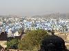
| Jodhpur FeatureType : null Elevation : 243 Lat/Lng : 26.28 / 73.02 | Jodhpur (; Listen) is the second largest city in the Indian state of Rajasthan and officially the second metropolitan city of the state. It was formerly the seat of a princely state of the same name. The capital of the kingdom was known as Marwar (...) |
| 3 | 
| San Jose, California FeatureType : null Elevation : 36 Lat/Lng : 37.3042 / -121.8728 | San Jose (; Spanish for 'Saint Joseph';),In isolation, San is pronounced . officially the City of San José, is an economic, cultural and political center of Silicon Valley, and the largest city in Northern California (both in population and area) (...) |
| 4 | 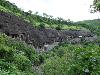
| Ajanta Caves FeatureType : landmark Elevation : 580 Lat/Lng : 20.5336 / 75.7497 | The Ajanta Caves are 30 (approximately) rock-cut Buddhist cave monuments which date from the 2nd century BCE to about 480 CE in Aurangabad district of Maharashtra state of India. The caves include paintings and rock-cut sculptures described as among the finest surviving examples of ancient Indian (...) |
| 5 | 
| LIGO FeatureType : null Elevation : 163 Lat/Lng : 46.4551 / -119.4077 | The Laser Interferometer Gravitational-Wave Observatory (LIGO) is a large-scale physics experiment and observatory to detect cosmic gravitational waves and to develop gravitational-wave observations as an astronomical tool (...) |
| 6 | 
| Town Musicians of Bremen FeatureType : landmark Elevation : 17 Lat/Lng : 53.0762 / 8.8075 | The "Town Musicians of Bremen" is a popular fairy tale retrieved and recorded by the Brothers Grimm. It was first published in Grimms' Fairy Tales in 1819. It tells the story of four aging domestic animals, who after a lifetime of hard work are neglected and mistreated by their former masters (...) |
| 7 | 
| Matheran FeatureType : null Elevation : 766 Lat/Lng : 18.9878 / 73.2707 | Matheran is a hill station and a municipal council in Karjat Tahsilin the Raigad district in the Indian state of Maharashtra. It is one of the smallest hill station in India, it is located on the Western Ghats range at an elevation of around 800 m (2,625 feet) above sea level (...) |
| 8 | Kolhapur FeatureType : null Elevation : 561 Lat/Lng : 16.6917 / 74.2333 | Kolhapur (Kolhapur.ogg) is a historic city of Maharashtra. It is the district headquarters of Kolhapur district. Prior to Indian Independence, Kolhapur was a nineteen gun salute princely state ruled by the Bhosale Chhatrapati (Bhosale royal clan) of the Maratha Empire. (...) | |
| 9 | Udupi FeatureType : null Elevation : 26 Lat/Lng : 13.3389 / 74.7451 | Udupi is a city in the Indian state of Karnataka. It is the administrative headquarters of Udupi District. Udupi is one of the top tourist attractions in Karnataka. It is notable for the Krishna Temple. It lends its name to the popular Udupi cuisine (...) | |
| 10 | Dhule FeatureType : null Elevation : 264 Lat/Lng : 20.8997 / 74.7697 | Dhule is one of the major cities in India situated on the banks of Panzara River. It is a municipal corporation in Dhule District in the northwestern part of Maharashtra state, India known as Khandesh. The town planning of this city was done by Sir Mokshagundam Visvesvaraya (...) | |
| 11 | Akola FeatureType : city Elevation : 277 Lat/Lng : 20.7333 / 77.0 | Akola is called the Cotton City; it is one of the largest cotton-producing districts in central India. The city is also known for the vibrant Varhadi language. The city of Akola is located in the north central part of Maharashtra state, western India, on the banks of Morna River and it is an (...) | |
| 12 | Osmanabad FeatureType : null Elevation : 662 Lat/Lng : 18.1794 / 76.0397 | Osmanabad pronunciation (transliterated in Marathi as Usmanabad) is a city and a municipal council in Osmanabad district in the Indian state of Maharashtra. Osmanabad derives its name from the last ruler of Hyderabad, Mir Osman Ali Khan. (...) | |
| 13 | Koppal district FeatureType : null Elevation : 531 Lat/Lng : 15.35 / 76.15 | Koppal district is an administrative district in the state of Karnataka in India. In the past Koppal was referred to as 'Kopana Nagara'. Hampi, a World heritage center, covers some areas of Koppal District. It is situated approximately 38 km away. Anegundi, is also a famous travel destination. (...) | |
| 14 | Sirohi FeatureType : null Elevation : 314 Lat/Lng : 24.885 / 72.8625 | Sirohi is a city in southern Rajasthan state in western India. It is the administrative headquarters of Sirohi District and was formerly the capital of the princely state of Sirohi ruled by Deora Chauhan Rajput (...) | |
| 15 | Western India FeatureType : null Elevation : 603 Lat/Lng : 19.0 / 74.15 | Western India is a loosely defined region of India consisting of its western part. The Ministry of Home Affairs in its Western Zonal Council Administrative division includes the states of Goa, Gujarat, and Maharashtra along with the Union territory of Daman and Diu and Dadra and Nagar Haveli while (...) | |
| 16 | Assassination of Mahatma Gandhi FeatureType : event Elevation : 213 Lat/Lng : 28.6013 / 77.2137 | Mahatma Gandhi was assassinated on 30 January 1948 in the compound of Birla House (now Gandhi Smriti), a large mansion. His assassin was Nathuram Vinayak Godse, a right-wing advocate of Hindu nationalism, a member of the political party the Hindu Mahasabha, and a past member of the Rashtriya (...) | |
| 17 | Alliance Française FeatureType : null Elevation : 51 Lat/Lng : 48.8464 / 2.3286 | L'Alliance Française (French Alliance), or AF, is an international organization that aims to promote French language and culture around the world. Created in Paris on 21 July 1883 under the name Alliance française pour la propagation de la langue nationale dans les colonies et à l'étranger (French (...) | |
| 18 | 2018 Indian Premier League FeatureType : null Elevation : 8 Lat/Lng : 18.975 / 72.8258 | The 2018 season of the Indian Premier League, also known as IPL 11, was the eleventh season of the IPL, a professional Twenty20 cricket league established by the BCCI in 2007. The season, which is being held from 7 April to 27 May, saw the return of the Chennai Super Kings and the Rajasthan Royals (...) | |
| 19 | Borivali FeatureType : city Elevation : 22 Lat/Lng : 19.235 / 72.8598 | Borivali is a neighborhood located in north-west Mumbai. Borivali is approximately from Mumbai Airport. The estimated population of Borivali in 2010 was 513,077. (...) | |
| 20 | Jalna, Maharashtra FeatureType : null Elevation : 504 Lat/Lng : 19.841 / 75.8864 | Jalna pronunciation is a city in Jalna district in the Aurangabad Division, or Marathwada region, of the Indian state of Maharashtra. It was part of Hyderabad State as a tehsil of Aurangabad district, before Jalna district was formed effective 1 May 1981. (...) | |
| 21 | Chakradharpur FeatureType : null Elevation : 234 Lat/Lng : 22.6763 / 85.6291 | Chakradharpur is a city with a municipality in West Singhbhum district in the state of Jharkhand, India. It is located on the Chota Nagpur Plateau west of Jamshedpur by Railway, south of Ranchi by Road, east of Rourkela by Railway and north of Chaibasa by Road (which is the district headquarters) (...) | |
| 22 | Vaijapur FeatureType : null Elevation : 534 Lat/Lng : 19.9267 / 74.7275 | Vaijapur is a city and a municipal council in Aurangabad district in the Indian state of Maharashtra. It is bordered by the Nashik districts to the west, Kannad tehsil to the north, Gangapur tehsil to the east, and Ahmednagar districts to the south (...) | |
| 23 | North Halmahera Regency FeatureType : null Elevation : 10 Lat/Lng : 1.7319 / 128.0078 | North Halmahera Regency is a regency (on Halmahera Island) of North Maluku Province, Indonesia. It was declared a Regency on 31 May 2003. The capital town of the regency lies at the port of Tobelo. The Regency, which has been considerably reduced by the separation of Tidore and (more recently) of (...) | |
| 24 | Eaglenest Wildlife Sanctuary FeatureType : null Elevation : 2231 Lat/Lng : 27.1 / 92.4 | Eaglenest or Eagle's Nest Wildlife Sanctuary is a protected area of India in the Himalayan foothills of West Kameng District, Arunachal Pradesh. It conjoins Sessa Orchid Sanctuary to the northeast and Pakhui Tiger Reserve across the Kameng river to the east. Altitude ranges are extreme: from to (...) | |
| 25 | Hatti Gold Mines FeatureType : null Elevation : 530 Lat/Lng : 16.1894 / 76.6547 | Hutti Gold Mines also spelled as Hatti is a town in Raichur district in the Indian state of Karnataka. (...) | |
| 26 | Narkhed FeatureType : null Elevation : 424 Lat/Lng : 21.4383 / 78.5683 | Narkhed is a town and a municipal council in Nagpur district in the Indian state of Maharashtra. It is about 84 km north-west of Nagpur. It is the administrative headquarters of Narkhed taluka, one of the 14 talukas of this district (...) | |
| 27 | Indian annexation of Hyderabad FeatureType : null Elevation : 371 Lat/Lng : 17.0 / 78.8333 | Operation Polo is the code name of the Hyderabad "police action" in September 1948, by the newly independent India against the Hyderabad State. It was a military operation in which the Indian Armed Forces invaded the Nizam-ruled princely state, annexing it into the Indian Union (...) | |
| 28 | Shantinath Jain Teerth FeatureType : null Elevation : 526 Lat/Lng : 18.1239 / 75.0176 | Shri 1008 Shantinath Digambar Jain Mandir is located in Indapur, District Pune in Maharashtra. This is the new south pattern temple. The main attraction of this temple is 27 feet tall granite idol of Shri 1008 Munisuvrata Bhagwan. The temple is golden in colour. So it is now called as Golden Temple (...) | |
| 29 | S.E.S. High School and Junior College FeatureType : null Elevation : 19 Lat/Lng : 19.1943 / 72.9676 | Saraswati Education Society's High School and Junior College, more commonly known as SES High School, is one of the oldest educational institutions in Thane city of India, located at Panchpakhadi, teaching pre-primary (Jr and Sr Kg), primary (1st to 4th), secondary (5th to 10th) and junior college (...) | |
| 30 | Indian Army FeatureType : null Elevation : 114 Lat/Lng : 26.5333 / 94.2167 | The Indian Army is the land-based branch and the largest component of the Indian Armed Forces. The President of India is the Supreme Commander of the Indian Army, and it is commanded by the Chief of Army Staff (COAS), who is a four-star general (...) | |
| 31 | Chandgad FeatureType : null Elevation : 740 Lat/Lng : 15.9333 / 74.2 | Chandgad is a town and tehsil headquarters in Gadhinglaj, which is a subdivision of Kolhapur district that is in the Indian state of Maharashtra. Jagrut Devastan Sri Ravalnath temple is located here. This is a small town having a population of about 12,000 (...) | |
| 32 | Institute of Chemical Technology FeatureType : null Elevation : 9 Lat/Lng : 19.024 / 72.859 | Institute of Chemical Technology (ICT), formerly the University Department of Chemical Technology (UDCT), is a chemical technology research university located in Mumbai, India. The institute also has campuses at Jalna, Marathwada and Bhubaneshwar (in collaboration with IndianOil Corporation and IIT (...) | |
| 33 | Vele-Kamthi FeatureType : null Elevation : 716 Lat/Lng : 17.7308 / 73.8795 | Vele (Kamthi) is a village in the Western region of Maharashtra state in India. It is located in Satara district of Maharashtra. Before it was a part of Bombay State and Princely state of Satara. It is located adjacent to Kanher Dam built on Venna River (...) | |
| 34 | Durrani Empire FeatureType : null Elevation : 1796 Lat/Lng : 34.5333 / 69.1667 | The Durrani Empire , also called the Afghan Empire , was founded and built by Ahmad Shah Durrani. At its maximum extent, the empire covered the modern-day Afghanistan, Pakistan, as well as some parts of northeastern Iran, eastern Turkmenistan, and northwestern India including the Kashmir region (...) | |
| 35 | Begumpet railway station FeatureType : null Elevation : 531 Lat/Lng : 17.4387 / 78.4586 | Begumpet Railway Station (station code:BMT) is a railway station and railway junction in Hyderabad, India. It falls under the common capital area shared between the states of Telangana and Andhra Pradesh. Localities like Ameerpet, Greenlands and Somajiguda are accessible from this station. (...) | |
| 36 | AISSMS College of Pharmacy FeatureType : null Elevation : 548 Lat/Lng : 18.5309 / 73.8667 | AISSMS College of Pharmacy, Pune is a Pharmacy college affiliated to the AICTE, PCI, New Delhi and University of Pune, India. It was established in 1996. AISSMS COP is among the top Pharmacy colleges in the private sector in Maharashtra (...) | |
| 37 | Sabarmati Riverfront FeatureType : null Elevation : 38 Lat/Lng : 23.0341 / 72.5723 | Sabarmati Riverfront is a waterfront being developed along the banks of Sabarmati river in Ahmedabad, India. Proposed in 1960s, the construction began in 2005. Since 2012, the waterfront is gradually opened to public as and when facilities are constructed and various facilities are actively under (...) | |
| 38 | Rishi Valley School FeatureType : landmark Elevation : 712 Lat/Lng : 13.634 / 78.454 | Rishi Valley School is an Indian boarding school, founded by the philosopher Jiddu Krishnamurti. The school has a holistic approach to education in the spirit of Krishnamurti's pedagogical vision. Community service and extracurricular activities are part of a student's schooling, as are discussions, (...) | |
| 39 | Halliburton FeatureType : null Elevation : 25 Lat/Lng : 29.9364 / -95.3404 | Halliburton Company is an American multinational corporation. One of the world's largest oil field service companies, it has operations in more than 70 countries. It owns hundreds of subsidiaries, affiliates, branches, brands, and divisions worldwide and employs approximately 50,000 people (...) | |
| 40 | Mumbai Trans Harbour Link FeatureType : null Lat/Lng : 19.0821 / 72.741 | The Mumbai Trans Harbour Link (MTHL), also known as the Sewri-Nhava Sheva Trans Harbour Link, is an under-construction 21.8 km, freeway grade road bridge connecting the Indian city of Mumbai with Navi Mumbai, its satellite city. When completed, it would be the longest sea bridge in India (...) | |
| 41 | Chalisgaon Junction railway station FeatureType : railwaystation Elevation : 352 Lat/Lng : 20.4639 / 74.9992 | Chalisgaon Railway Station serves Chalisgaon in Jalgaon district in the Indian state of Maharashtra. (...) | |
| 42 | Murtajapur FeatureType : null Elevation : 303 Lat/Lng : 20.733 / 77.3669 | Murtajapur is a municipal council and one of the taluka of district of Akola of Amravati division of Vidarbha region of Maharashtra. (...) | |
| 43 | Malkapur, Karad FeatureType : null Elevation : 572 Lat/Lng : 17.28 / 74.2 | Malkapur is a city in Satara district in the southern part of Indian state of Maharashtra. It lies besides the city of Karad and along the NH4 highway. It had one of the highest revenue generating (through taxes) Gram Panchayats in Maharashtra (...) | |
| 44 | Ranjangaon Sandas FeatureType : null Elevation : 532 Lat/Lng : 18.5719 / 74.3447 | Ranjangaon Sandas (Mr:रांजणगाव सांडस) is a panchayat village2011 Village Panchayat Code for Ranjangaon Sandas = 188613, in the state of Maharashtra, India,2001 Census Village code for Ranjangaon Sandas = 03052300, 2011 Census Village code for Ranjangaon Sandas = 555652, on the left (east) bank of (...) | |
| 45 | Dr. Y. S. Rajasekhara Reddy ACA–VDCA Cricket Stadium FeatureType : null Elevation : 58 Lat/Lng : 17.7974 / 83.3519 | Visakhapatnam Dr. Y.S. Rajashekhar Reddy ACA-VDCA Cricket Stadium , also known as the ACA-VDCA Cricket Stadium, is a multi-purpose stadium in Visakhapatnam, India with a lush green outfield. It is primarily used for Cricket (...) | |
| 46 | Kodaikanal Solar Observatory FeatureType : null Elevation : 2340 Lat/Lng : 10.2322 / 77.4647 | The Kodaikanal Solar Observatory is a solar observatory owned and operated by the Indian Institute of Astrophysics. It is on the southern tip of the Palani Hills 4 km from Kodaikanal town, Dindigul district, Tamil Nadu state, South India (...) | |
| 47 | Suvarna Vidhana Soudha FeatureType : null Elevation : 835 Lat/Lng : 15.8134 / 74.5714 | The Suvarna Vidhana Soudha is a new legislature building of the State of Karnataka in Belagavi in the Belgaum district of Northern Karnataka. It was inaugurated on 11 October 2012 by President Pranab Mukherjee. (...) | |
| 48 | Karawadi FeatureType : null Elevation : 592 Lat/Lng : 17.33 / 74.2 | Karawadi is a village panchayat located in the Karad taluka of Satara district in the southern part of Indian state of Maharashtra. It belongs to Western Maharashtra region. It has a population of 3,588 according to 2011 census. The nearby villages include Ogalewadi, Viravade, Wagheri (...) | |
| 49 | Savarde Budhruk FeatureType : null Elevation : 567 Lat/Lng : 16.27 / 74.12 | Savarde Bk situated in the south-west corner of Maharashtra, India. The population of Savarde Bk was approx 6000 as per the 2001 census.As is the case in most of the Maharashtra cities, the main language spoken here is Marathi. (...) | |
| 50 | Blathur FeatureType : null Elevation : 47 Lat/Lng : 11.9889 / 75.5817 | Blathur is a village in Kannur, Kerala, India, located approximately 38 kilometres north-east of the district headquarters, Kannur. The nearest town, Irikkur, is estimated to be 7 kilometres from the village itself (...) | |
| 51 | Gesellschaft für deutsche Sprache FeatureType : null Elevation : 127 Lat/Lng : 50.0855 / 8.2421 | The ' (Association for the German Language), or , is Germany's most important government-sponsored language society. Its headquarters are in Wiesbaden Re-founded shortly after the Second World War in 1947, the is politically independent and the declared successor of the ' , the General Association (...) | |
| 52 | National Academy of Indian Railways FeatureType : edu Elevation : 38 Lat/Lng : 22.2806 / 73.2002 | The National Academy of Indian Railways (NAIR), Vadodara formerly Railway Staff College is a Centralised Training Institute for Group A and B Officers of Indian Railways (IR), headed by a Director General and manned by an faculty of experienced Railway Managers and Experts (...) | |
| 53 | Jadayampalayam Pudur FeatureType : null Elevation : 329 Lat/Lng : 11.293 / 76.9495 | Jadayampalayam Pudur is a small village, located 4 km from Mettupalayam town, on Mettupalayam-Tirupur state highway 80. The village become very famous because of its residential development. (...) | |
 by
by