| 43 records found in wikipedia | |||
| 1 | Midlothian, Virginia  FeatureType : city Elevation : 120 Lat/Lng : 37.5215 / -77.6648 | Midlothian, Virginia is an unincorporated area in Chesterfield County, Virginia, U.S. Founded over 300 years ago as a coal town, it is now a suburban community located west of Richmond, Virginia and south of the James River in the Greater Richmond Region (...) | |
| 2 | 
| South Uist FeatureType : isle Elevation : 229 Lat/Lng : 57.267 / -7.317 | South Uist is the second-largest island of the Outer Hebrides in Scotland. At the 2011 census, it had a usually resident population of 1,754: a decrease of 64 since 2001. The island, in common with the rest of the Hebrides, is one of the last remaining strongholds of the Gaelic language in Scotland (...) |
| 3 | 
| North Uist FeatureType : isle Elevation : 204 Lat/Lng : 57.6058 / -7.3414 | North Uist is an island and community in the Outer Hebrides of Scotland. (...) |
| 4 | 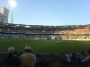
| The Gabba FeatureType : landmark Elevation : 9 Lat/Lng : -27.4858 / 153.0381 | The Brisbane Cricket Ground, commonly known as the Gabba, is a major sports stadium in Brisbane, the capital of Queensland, Australia. The nickname Gabba derives from the suburb of Woolloongabba, in which it is located (...) |
| 5 | 
| Richmond, Virginia FeatureType : city Elevation : 55 Lat/Lng : 37.5489 / -77.4474 | Richmond is the capital of the Commonwealth of Virginia in the United States. It is the center of the Richmond Metropolitan Statistical Area (MSA) and the Greater Richmond Region. Richmond was incorporated in 1742 and has been an independent city since 1871 (...) |
| 6 | 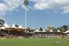
| Adelaide Oval FeatureType : null Elevation : 25 Lat/Lng : -34.9156 / 138.5961 | Adelaide Oval is a sports ground in Adelaide, South Australia, located in the parklands between the city centre and North Adelaide. The venue is predominantly used for cricket and Australian rules football, but has also played host to rugby league, rugby union, soccer, tennis among other sports as (...) |
| 7 | 
| Ebbets Field FeatureType : landmark Elevation : 47 Lat/Lng : 40.665 / -73.9581 | Ebbets Field was a Major League Baseball stadium in the Flatbush section of Brooklyn, New York. It is known mainly as the home of the Brooklyn Dodgers baseball team of the National League, from 1913 to 1957, but was also home to three National Football League teams in the 1920s (...) |
| 8 | 
| Murrayfield Stadium FeatureType : landmark Elevation : 59 Lat/Lng : 55.942 / -3.241 | Murrayfield Stadium is a sports stadium located in the west end of Edinburgh, the capital of Scotland. Its all-seater capacity is 67,144 which makes it the largest stadium in Scotland and the fifth largest in the United Kingdom (...) |
| 9 | 
| Craigmillar Castle FeatureType : landmark Elevation : 90 Lat/Lng : 55.9256 / -3.1408 | Craigmillar Castle is a ruined medieval castle in Edinburgh, Scotland. It is south-east of the city centre, on a low hill to the south of the modern suburb of Craigmillar. The Preston family of Craigmillar, the local feudal barons, began building the castle in the late 14th century and building (...) |
| 10 | Tesco FeatureType : landmark Elevation : 25 Lat/Lng : 51.7052 / -0.0268 | Tesco plc, trading as Tesco, is a British multinational groceries and general merchandise retailer with headquarters in Welwyn Garden City, Hertfordshire, England, United Kingdom. It is the third-largest retailer in the world measured by gross revenues and ninth-largest retailer in the world (...) | |
| 11 | Milton Keynes Dons F.C. FeatureType : null Elevation : 90 Lat/Lng : 52.0377 / -0.775 | Milton Keynes Dons Football Club , usually abbreviated to MK Dons, is a professional association football club based in Milton Keynes, Buckinghamshire, England. It was founded in 2004, following Wimbledon F.C.'s controversial relocation to Milton Keynes from south London, when it adopted its present (...) | |
| 12 | Portsmouth F.C. FeatureType : landmark Elevation : 5 Lat/Lng : 50.7964 / -1.0639 | Portsmouth Football Club is an English professional association football club in Portsmouth, Hampshire, which plays in EFL League One, the third tier of English football, following their promotion as EFL League Two champions in the 2016–17 EFL League Two season (...) | |
| 13 | Royal Mile FeatureType : null Elevation : 75 Lat/Lng : 55.9506 / -3.1856 | The Royal Mile is a succession of streets forming the main thoroughfare of the Old Town of the city of Edinburgh in Scotland. The term was first used descriptively in W M Gilbert's Edinburgh in the Nineteenth Century (1901), ".. (...) | |
| 14 | Bonnyrigg FeatureType : null Elevation : 101 Lat/Lng : 55.8747 / -3.1031 | Bonnyrigg is a town in Midlothian, Scotland, eight miles (13 kilometres) southeast of Edinburgh city centre. The town had a population of 14,663 in the 2001 census which has risen to 15,677 according to the 2011 census, both figures based on the 2010 definition of the locality which, as well as (...) | |
| 15 | Scottish Premiership FeatureType : null Elevation : 19 Lat/Lng : 55.858 / -4.259 | The Scottish Premiership, known for sponsorship reasons as the Ladbrokes Premiership, is the top division of the Scottish Professional Football League (SPFL), the league competition for men's professional football clubs in Scotland (...) | |
| 16 | Selkirkshire FeatureType : adm2nd Elevation : 337 Lat/Lng : 55.5 / -3.0 | Selkirkshire or the County of Selkirk is a historic county and registration county of Scotland. It borders Peeblesshire to the west, Midlothian to the north, Roxburghshire to the east, and Dumfriesshire to the south. It derives its name from its county town, the Royal burgh of Selkirk (...) | |
| 17 | Newbattle Abbey FeatureType : landmark Elevation : 51 Lat/Lng : 55.8828 / -3.0672 | Newbattle Abbey was a Cistercian monastery near the village of Newbattle in Midlothian, Scotland, which subsequently become a stately home and then an educational institution. (...) | |
| 18 | Whitburn, West Lothian FeatureType : null Elevation : 173 Lat/Lng : 55.8667 / -3.6833 | Whitburn (originally Whiteburn) is a small town in West Lothian, Scotland, halfway between Scotlands's two largest cities, about east of Glasgow and west of Edinburgh. The nearest major towns are Bathgate, and Livingston, . (...) | |
| 19 | Lambroughton FeatureType : null Elevation : 71 Lat/Lng : 55.6628 / -4.5399 | Lambroughton is a village in the old Barony of Kilmaurs, East Ayrshire, Scotland. This is a rural area famous for its milk and cheese production and the Ayrshire or Dunlop breed of cattle. (...) | |
| 20 | Unite the Right rally FeatureType : null Elevation : 140 Lat/Lng : 38.0295 / -78.4795 | The Unite the Right rally, also known as the Charlottesville rally or Charlottesville riots, was a white supremacist rally that occurred in Charlottesville, Virginia, from August 11 to 12, 2017., BBC News (August 13, 2017) (...) | |
| 21 | Blue Peter FeatureType : null Elevation : 12 Lat/Lng : 51.5106 / -0.2277 | Blue Peter is a British children's television programme that was first broadcast in 1958. The programme, which has had continuous seasons since it was first aired, is now the longest-running children's TV show in the world. It is currently shown live on the CBBC television channel (...) | |
| 22 | Holyrood Park FeatureType : null Elevation : 152 Lat/Lng : 55.9484 / -3.1589 | Holyrood Park (also called the Queen's Park or King's Park depending on the reigning monarch's gender) is a royal park in central Edinburgh, Scotland about to the east of Edinburgh Castle. It is open to the public (...) | |
| 23 | Castle Law FeatureType : null Elevation : 479 Lat/Lng : 55.8698 / -3.24 | Castle Law is a hill south west of Fairmilehead in the Pentland Hills in Midlothian, Scotland. It is best known for the Iron Age hill fort on its slopes. (...) | |
| 24 | Bristol City F.C. FeatureType : null Elevation : 9 Lat/Lng : 51.44 / -2.6203 | Bristol City Football Club is a professional football club in Bristol, England, who currently play in the Championship, the second tier of English football. Founded in 1894, they have played their home games at Ashton Gate since 1904 (...) | |
| 25 | Inveresk FeatureType : null Elevation : 22 Lat/Lng : 55.937 / -3.047 | Inveresk (Gaelic: Inbhir Easg) is a village in East Lothian, Scotland situated immediately to the south of Musselburgh. It has been designated a conservation area since 1969. It is situated on slightly elevated ground on the north bank of a loop of the River Esk (...) | |
| 26 | Corstorphine FeatureType : null Elevation : 56 Lat/Lng : 55.9429 / -3.2854 | Corstorphine is a village and parish to the west of Edinburgh, now considered a suburb of that city. Corstorphine retains a busy high street with many independent small shops, although a number have closed in recent years since the opening of several retail parks to the west of Edinburgh, especially (...) | |
| 27 | Texas A&M University–Commerce FeatureType : landmark Elevation : 176 Lat/Lng : 33.2423 / -95.9077 | Texas A&M University–Commerce is a public research university in Commerce, Texas. With an enrollment of over 12,000 students as of fall 2016, the university is the third largest institution in the Texas A&M University System (...) | |
| 28 | Royal Commission on the Ancient and Historical Monuments of Scotland FeatureType : null Elevation : 86 Lat/Lng : 55.9409 / -3.1797 | The Royal Commission on the Ancient and Historical Monuments of Scotland (RCAHMS) was an executive non-departmental public body of the Scottish Government, which was "sponsored" through Historic Scotland, an executive agency of the Scottish Government (...) | |
| 29 | Muckhart FeatureType : null Elevation : 154 Lat/Lng : 56.1884 / -3.6112 | Muckhart commonly refers to two small villages in Clackmannanshire, Scotland, Pool of Muckhart and Yetts o' Muckhart. Muckhart is one of the Hillfoots Villages, situated on the A91 around 3 miles north-east of Dollar (...) | |
| 30 | Clan Buchanan FeatureType : null Elevation : 18 Lat/Lng : 56.0683 / -4.4844 | Clan Buchanan is a Scottish clan whose origins are said to lie in the 1225 grant of lands on the eastern shore of Loch Lomond to clergyman Sir Absalon of Buchanan by the Earl of Lennox."The Scottish Clans and Their Tartans". W. & A. K. Johnston Limited. Edinburgh and London. 1886. Page 3. (...) | |
| 31 | Crichton Castle FeatureType : landmark Elevation : 195 Lat/Lng : 55.8411 / -2.9895 | Crichton Castle is a ruined castle near the village of Crichton in Midlothian, Scotland. It is situated at the head of the River Tyne, south of the village of Pathhead, and the same distance east of Gorebridge. Constructed as a tower house in the late 14th century, and it was expanded as power of (...) | |
| 32 | Melville FeatureType : null Lat/Lng : -62.021 / -57.6711 | Melville may refer to the American writer Herman Melville. It may also refer to: (...) | |
| 33 | Fala, Midlothian FeatureType : null Elevation : 238 Lat/Lng : 55.834 / -2.884 | Fala is a hamlet in the south-eastern corner of Midlothian, Scotland, and about 15 miles from Edinburgh. (...) | |
| 34 | St Boswells FeatureType : null Elevation : 96 Lat/Lng : 55.573 / -2.6441 | St Boswells An Stòr-dàta Briathrachais , retrieved 03.02.2010 is a village (population 1,412) on the south side of the River Tweed in the Scottish Borders, about 1 mile SE of Newtown St Boswells on the A68 road. It lies within the boundaries of the historic county of Roxburghshire (...) | |
| 35 | Outline of Edinburgh FeatureType : null Elevation : 73 Lat/Lng : 55.9531 / -3.1889 | The following outline is provided as an overview of and topical guide to Edinburgh: Edinburgh – (...) | |
| 36 | Cockpen FeatureType : null Elevation : 82 Lat/Lng : 55.8662 / -3.0892 | Cockpen is a parish in Midlothian, Scotland, containing at its north-west corner the town of Bonnyrigg, which lies south-west of Dalkeith. It is bounded on the west and north by the parish of Lasswade, on the east, by Newbattle and on the south by Carrington (...) | |
| 37 | Lyne, Scottish Borders FeatureType : city Elevation : 249 Lat/Lng : 57.3333 / -3.4 | Lyne is a small village and civil parish in the Scottish Borders area of Scotland, west of the market town of Peebles; it lies off the A72, in the old county of Peeblesshire and has an area of about . The Lyne Water flows through the village on its journey from the Pentland Hills to the River Tweed (...) | |
| 38 | Stichill FeatureType : null Elevation : 125 Lat/Lng : 55.639 / -2.458 | Stichill is a village and civil parish in the historic county of Roxburghshire, a division of the Scottish Borders. Situated north of the Burgh of Kelso, Stichill lies north of the Eden Water and from the English Border at Coldstream (...) | |
| 39 | Potheridge FeatureType : null Elevation : 145 Lat/Lng : 50.9123 / -4.1155 | Potheridge (alias Poderigge, Poderidge, Powdrich, etc.), in the parish of Merton, in the historic hundred of Shebbear, 3 miles south-east of Great Torrington, Devon, England, is a former Domesday Book estate and the site of the former grand mansion house re-built by George Monck, 1st Duke of (...) | |
| 40 | Carrington (disambiguation) FeatureType : null Elevation : 21 Lat/Lng : 53.4333 / -2.3833 | Carrington is an English surname. Carrington may also refer to: (...) | |
| 41 | Musée de la Vie romantique FeatureType : landmark Elevation : 60 Lat/Lng : 48.881 / 2.333 | The Musée de la Vie romantique (The Museum of Romantic Life, or Museum of the Romantics) stands at the foot of Montmartre hill in the 9th arrondissement of Paris, 16 rue Chaptal, Paris, France in an 1830 hôtel particulier facing two twin-studios, a greenhouse, a small garden, and a paved courtyard (...) | |
| 42 | MV Nyon FeatureType : null Lat/Lng : 50.5333 / 1.5 | Nyon was a cargo ship that was built in 1952. She ran aground in 1958, and was cut in two in order to salvage her. The stern section was salvaged and a new bow section built and fitted in 1959. She served until 1962 when she was involved in a collision with another ship and sank. (...) | |
| 43 | St Mary's Kirk, Auchindoir FeatureType : null Elevation : 225 Lat/Lng : 57.3086 / -2.8686 | St Mary's Kirk at Auchindoir, between Rhynie and Lumsden, in Aberdeenshire, Scotland, is one of the country's finest surviving medieval parish kirks. The main doorway is early Romanesque, and there is a well-preserved early 16th-century sacrament house, similar to those at Deskford and Kinkell (...) | |
 by
by