| 55 records found in wikipedia | |||
| 1 | 
| Pakistan  FeatureType : country Elevation : 173 Lat/Lng : 30.6667 / 73.1667 | Pakistan , officially the Islamic Republic of Pakistan , is a country in South Asia. It is the sixth-most populous country with a population exceeding 212,742,631 people. In area, it is the 33rd-largest country, spanning (...) |
| 2 | Punjab, Pakistan FeatureType : adm1st Elevation : 205 Lat/Lng : 31.33 / 74.21 | Punjab (Urdu, Punjabi: , panj-āb, "five waters": listen) is Pakistan's second largest province by area, after Balochistan, and its most populous province, with an estimated population of 110,012,442 as of 2017. Forming part of the larger Punjab region of the Indian subcontinent, it is bordered by (...) | |
| 3 | 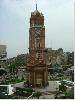
| Faisalabad FeatureType : null Elevation : 191 Lat/Lng : 31.4186 / 73.0789 | Faisalabad (; ; Lyallpur until 1979) is the third-most-populous city in Pakistan, and the second-largest in the eastern province of Punjab. Historically one of the first planned cities within British India, it has long since developed into a cosmopolitan metropolis (...) |
| 4 | 
| Trafalgar Square FeatureType : landmark Elevation : 19 Lat/Lng : 51.5081 / -0.1281 | Trafalgar Square is a public square in the City of Westminster, Central London, built around the area formerly known as Charing Cross. Its name commemorates the Battle of Trafalgar, a British naval victory in the Napoleonic Wars with France and Spain that took place on 21 October 1805 off the coast (...) |
| 5 | 
| Bangalore FeatureType : city Elevation : 926 Lat/Lng : 12.9779 / 77.5925 | Bangalore , officially known as Bengaluru , is the capital of the Indian state of Karnataka. It has a population of over ten million, making it a megacity and the third most populous city and fifth most populous urban agglomeration in India. It is located in southern India on the Deccan Plateau (...) |
| 6 | 
| Bengal FeatureType : adm1st Elevation : 26 Lat/Lng : 24.0 / 88.0 | Bengal is a geopolitical, cultural and historical region in South Asia, specifically in the eastern part of the Indian subcontinent at the apex of the Bay of Bengal. Geographically, it is made up by the Ganges-Brahmaputra delta system, the largest such formation in the world; along with mountains in (...) |
| 7 | 
| Chengdu FeatureType : adm2nd Elevation : 507 Lat/Lng : 30.657 / 104.066 | Chengdu , formerly romanized as Chengtu, is a sub-provincial city which serves as the capital of Sichuan province, People's Republic of China. It is one of the three most populous cities in Western China, the other two being Chongqing and Xi'an (...) |
| 8 | 
| Friends FeatureType : null Elevation : 15 Lat/Lng : 40.7325 / -74.0055 | Friends is an American television sitcom, created by David Crane and Marta Kauffman, which aired on NBC from September 22, 1994, to May 6, 2004, lasting ten seasons. With an ensemble cast starring Jennifer Aniston, Courteney Cox, Lisa Kudrow, Matt LeBlanc, Matthew Perry and David Schwimmer, the show (...) |
| 9 | 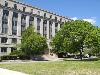
| Massachusetts Institute of Technology FeatureType : edu Elevation : 17 Lat/Lng : 42.3598 / -71.0921 | The Massachusetts Institute of Technology (MIT) is a private research university in Cambridge, Massachusetts. Founded in 1861 in response to the increasing industrialization of the United States, MIT adopted a European polytechnic university model and stressed laboratory instruction in applied (...) |
| 10 | Punjab, India FeatureType : adm1st Elevation : 365 Lat/Lng : 30.79 / 76.78 | Punjab is a state in northern India. Forming part of the larger Punjab region of the Indian subcontinent, the state is bordered by the Indian states of Jammu and Kashmir to the north, Himachal Pradesh to the east, Haryana to the south and southeast, Rajasthan to the southwest, and the Pakistani (...) | |
| 11 | University of Engineering and Technology, Lahore FeatureType : null Elevation : 217 Lat/Lng : 31.5799 / 74.3561 | The University of Engineering and Technology, Lahore (; abbreviated as UET Lahore) is a public university located in Lahore, Punjab, Pakistan specializing in Science, technology, engineering and mathematics (STEM) subjects (...) | |
| 12 | 2011 Cricket World Cup FeatureType : null Elevation : 7 Lat/Lng : 22.3217 / 91.8153 | The 2011 ICC Cricket World Cup (officially known as ICC Cricket World Cup 2011) was the tenth Cricket World Cup. It was played in India, Sri Lanka, and (for the first time) Bangladesh. India won the tournament, defeating Sri Lanka by 6 wickets in the final at Wankhede Stadium in Mumbai, thus (...) | |
| 13 | Gujranwala FeatureType : city Elevation : 229 Lat/Lng : 32.1556 / 74.2006 | Gujranwala (Punjabi) is a city in Punjab, Pakistan, that is located north of the nearby provincial capital of Lahore. The city is Pakistan's 7th most-populous metropolitan area, and its 5th most populous city proper (...) | |
| 14 | Canal FeatureType : null Elevation : 11 Lat/Lng : 51.1384 / -2.7358 | Canals, or navigations, are human-made channels, or artificial waterways, for water conveyance, or to service water transport vehicles. In most cases, the engineered works will have a series of dams and locks that create reservoirs of low speed current flow (...) | |
| 15 | Lahore Ahmadiyya Movement for the Propagation of Islam FeatureType : landmark Elevation : 17 Lat/Lng : 51.4222 / -0.1706 | The Lahore Ahmadiyya Movement for the Propagation of Islam, (; Aḥmadiyyah Anjuman-i Ishāʿat-i Islām, Lāhawr) is a separatist group within the Ahmadiyya movement that formed in 1914 as a result of ideological and administrative differences following the demise of Hakim Nur-ud-Din, the first Caliph (...) | |
| 16 | Diana, Princess of Wales FeatureType : null Elevation : 98 Lat/Lng : 52.2831 / -1.0003 | Diana, Princess of Wales (born Diana Frances Spencer; 1 July 1961 – 31 August 1997), was a member of the British royal family. She was the first wife of Charles, Prince of Wales, the heir apparent to the British throne, and the mother of Prince William, Duke of Cambridge, and Prince Harry, Duke of (...) | |
| 17 | University of London FeatureType : null Elevation : 35 Lat/Lng : 51.5211 / -0.1289 | The University of London (abbreviated as Lond or more rarely Londin in post-nominals) is a collegiate federal research university located in London, England. As of October 2018, the university contains 18 member institutions (...) | |
| 18 | 7 July 2005 London bombings FeatureType : landmark Elevation : 26 Lat/Lng : 51.5168 / -0.0806 | The 7 July 2005 London bombings, often referred to as 7/7, were a series of coordinated terrorist suicide attacks in London, United Kingdom, which targeted commuters travelling on the city's public transport system during the morning rush hour (...) | |
| 19 | Jammu and Kashmir FeatureType : adm1st Elevation : 4832 Lat/Lng : 33.45 / 76.24 | Jammu and Kashmir (and) is a state in northern India, often denoted by its acronym, J&K. It is located mostly in the Himalayan mountains, and shares borders with the states of Himachal Pradesh and Punjab to the south (...) | |
| 20 | 2014 Lahore clash FeatureType : null Elevation : 215 Lat/Lng : 31.4833 / 74.309 | The Model Town Massacre, more commonly known as the Model Town tragedy or the Lahore massacre , or simply Lahore incident, was a violent clash that ensued between the Punjab Police and Pakistan Awami Tehreek activists on 17 June 2014 resulting in several protesters being killed by the police gunfire (...) | |
| 21 | Chicago FeatureType : null Elevation : 224 Lat/Lng : 41.8819 / -87.6278 | Chicago , formally the City of Chicago, is located on the shores of freshwater Lake Michigan, and is the third most populous city in the United States. As of the 2017 census-estimate, Chicago has a population of 2,716,450, which makes it the most populous city in both the state of Illinois and the (...) | |
| 22 | Second Battle of Ypres FeatureType : event Elevation : 34 Lat/Lng : 50.891 / 2.979 | During World War I, the Second Battle of Ypres was fought from for control of the strategic Flemish town of Ypres in western Belgium after the First Battle of Ypres the previous autumn. It was the first mass use by Germany of poison gas on the Western Front (...) | |
| 23 | Pakistan national cricket team FeatureType : null Elevation : 320 Lat/Lng : 34.0216 / 71.5784 | The Pakistan Men's National Cricket Team , popularly referred to as the Shaheens , Green Shirts and Men in Green,http://www.bbc.co.uk/programmes/p04x6xb6 BBC – When Pakistan's 'Cornered Tigers' Ruled the Worldhttp://www.espncricinfo.com/ci/content/story/410118 (...) | |
| 24 | Sultanpur Lodhi FeatureType : null Elevation : 217 Lat/Lng : 31.2147 / 75.196 | Sultanpur Lodhi is a city and a Municipal Council in Kapurthala district in the Indian state of Punjab. The town is named after its founder, Sultan Khan Lodhi, who was a general of Mahmud of Ghazni in 1103 AD, which has been also mentioned in Ain-e-Akbari (...) | |
| 25 | Hoshiarpur district FeatureType : null Elevation : 368 Lat/Lng : 31.5833 / 75.9833 | Hoshiarpur District is a district of Punjab state in northern India. Hoshiarpur, one of the oldest districts of Punjab, is located in the North-east part of the Punjab state and shares common boundaries with Gurdaspur district in the north-west, Jalandhar and Kapurthala districts in south-west, (...) | |
| 26 | Fokker F27 Friendship FeatureType : null Elevation : 2471 Lat/Lng : -32.1123 / -64.948 | The Fokker F27 Friendship is a turboprop airliner developed and manufactured by the Dutch aircraft manufacturer Fokker. It has the distinction of being the most numerous post-war aircraft to have been manufactured in the Netherlands; the F27 was also one of the most successful European airliners of (...) | |
| 27 | Alliance Française FeatureType : null Elevation : 51 Lat/Lng : 48.8464 / 2.3286 | L'Alliance Française (French Alliance), or AF, is an international organization that aims to promote French language and culture around the world. Created in Paris on 21 July 1883 under the name Alliance française pour la propagation de la langue nationale dans les colonies et à l'étranger (French (...) | |
| 28 | Association of Chartered Certified Accountants FeatureType : landmark Elevation : 8 Lat/Lng : 55.8581 / -4.274 | Founded in 1904, the Association of Chartered Certified Accountants (ACCA) is the global professional accounting body offering the Chartered Certified Accountant qualification (ACCA or FCCA). In March 2018, ACCA recorded that it has 208,000 members and 503,000 students in 179 countries (...) | |
| 29 | Lawrence Park FeatureType : null Elevation : 94 Lat/Lng : -36.7318 / 149.9679 | Lawrence Park may mean: *Lawrence Park, Toronto, Canada *Lawrence Park Township, Erie County, Pennsylvania, United States *Lawrence Park Historic District, Bronxville, New York, United States *Lawrence Gardens, Lahore, Pakistan | |
| 30 | Arya Samaj FeatureType : null Elevation : 477 Lat/Lng : 26.4499 / 74.6399 | Arya Samaj (Sanskrit: ' "Noble Society" Hindi: आर्य समाज, Bengali: আর্য সমাজ, Punjabi: ਆਰੀਆ ਸਮਾਜ, Gujarati: આર્ય સમાજ) is an Indian Hindu reform movement that promotes values and practices based on the belief in the infallible authority of the Vedas (...) | |
| 31 | Gated community FeatureType : null Elevation : 28 Lat/Lng : 52.4133 / 13.0903 | In its modern form, a gated community (or walled community) is a form of residential community or housing estate containing strictly controlled entrances for pedestrians, bicycles, and automobiles, and often characterized by a closed perimeter of walls and fences (...) | |
| 32 | Montgomery FeatureType : null Elevation : 76 Lat/Lng : 32.3668 / -86.3 | Montgomery may refer to: (...) | |
| 33 | Doaba FeatureType : null Elevation : 455 Lat/Lng : 31.3333 / 76.1667 | Doaba also known as Bist Doab, is the region of Punjab, India that lies between the Beas River and the Sutlej River. People of this region are given the demonym "Doabia". The dialect of Punjabi spoken in Doaba is called "Doabi" (...) | |
| 34 | University of Passau FeatureType : edu Elevation : 303 Lat/Lng : 48.5683 / 13.4533 | The University of Passau (Universität Passau in German) is a public research university located in Passau, Lower Bavaria, Germany. Founded in 1973, it is the youngest university in Bavaria and consequently has the most modern campus in the state (...) | |
| 35 | 2016 Pathankot attack FeatureType : event Elevation : 309 Lat/Lng : 32.2336 / 75.6344 | The 2016 Pathankot attack was a terrorist attack committed on 2 January 2016 by a heavily armed group which attacked the Pathankot Air Force Station, part of the Western Air Command of the Indian Air Force. Four attackers and two security forces personnel were killed in the initial battle, with an (...) | |
| 36 | Panjab University FeatureType : edu Elevation : 354 Lat/Lng : 30.758 / 76.7682 | Panjab University(in Punjabi ਪੰਜਾਬ ਯੂਨੀਵਰਸਿਟੀ) is a public collegiate university located in Chandigarh, India. It originated in 1882, but was established in 1947, making it one of the oldest universities in India (...) | |
| 37 | Gojra FeatureType : null Elevation : 171 Lat/Lng : 31.1503 / 72.6811 | Gojra (Punjabi and), the administrative capital of Gojra Tehsil, is the city of Toba Tek Singh District in the Punjab in the province of Pakistan. Gojra is 30 miles (50 km) from Faisalabad, 170 km from Lahore, and north of Toba Tek Singh (...) | |
| 38 | Crown Jewels of the United Kingdom FeatureType : landmark Elevation : 15 Lat/Lng : 51.5081 / -0.0761 | The Crown Jewels of the United Kingdom, originally the Crown Jewels of England, are 140 royal ceremonial objects kept in the Tower of London, which include the regalia and vestments worn by British kings and queens at their coronations. Symbols of 800 years of monarchy,Mears, et al., p. 5 (...) | |
| 39 | Washington, Kentucky FeatureType : null Elevation : 275 Lat/Lng : 38.6159 / -83.8085 | Washington is a neighborhood of the city of Maysville located near the Ohio River in Mason County in the U.S. state of Kentucky. It is one of the earliest settlements in Kentucky and also one of the earliest American settlements west of the Appalachian Mountains (...) | |
| 40 | Techfest FeatureType : null Elevation : 54 Lat/Lng : 19.1336 / 72.9154 | Techfest is the annual science and technology festival of Indian Institute of Technology Bombay. It also refers to the independent body of students who organize this event along with many other social initiatives and outreach programs around the year (...) | |
| 41 | Dry port FeatureType : null Elevation : 19 Lat/Lng : 59.79 / 30.409 | A dry port (sometimes inland port) is an inland intermodal terminal directly connected by road or rail to a seaport and operating as a centre for the transshipment of sea cargo to inland destinations. In addition to their role in cargo transshipment, dry ports may also include facilities for storage (...) | |
| 42 | Expo 2010 pavilions FeatureType : landmark Elevation : 0 Lat/Lng : 31.1941 / 121.4864 | This article contains the details of the pavilions in Expo 2010. The 2010 World Expo Shanghai is the largest Expo site ever, covering more than 5.2 square kilometers and containing more than 70 exposition pavilions (...) | |
| 43 | May 2017 Kabul attack FeatureType : landmark Elevation : 1798 Lat/Lng : 34.531 / 69.178 | On 31 May 2017, a truck bomb exploded in a crowded intersection in Kabul, Afghanistan, near the German embassy at about 08:25 local time (03:55 GMT) during rush hour, killing over 150 and injuring 413, mostly civilians, and damaging several buildings in the embassy (...) | |
| 44 | Battle of Mont Sorrel FeatureType : event Elevation : 43 Lat/Lng : 50.8464 / 2.9436 | The Battle of Mont Sorrel (Battle of Mount Sorrel, Battle of Hill 62) was a local operation in World War I by three divisions of the British Second Army and three divisions of the 4th Army in the Ypres Salient, near Ypres, Belgium, from 2 to 13 June 1916 (...) | |
| 45 | Gehlan Hithar FeatureType : city Elevation : 185 Lat/Lng : 30.9489 / 73.7433 | Gehlan Hithar is a town and Union Council of Kasur District, situated some 65 miles south west of Lahore, Punjab, Pakistan. . Nrb.gov.pk. Retrieved on 2012-01-14. It is located at 30°52'0N 74°1'60E with an altitude of 174 metres (574 feet). Fallingrain.com. Retrieved on 2012-01-14 (...) | |
| 46 | Minto FeatureType : null Elevation : 36 Lat/Lng : 46.0848 / -66.0622 | Minto may refer to: (...) | |
| 47 | Bishop Cotton School (Shimla) FeatureType : edu Elevation : 2020 Lat/Lng : 31.0853 / 77.1736 | Bishop Cotton School, Shimla, (Himachal Pradesh, India) is one of the oldest boarding schools for boys in Asia, having been founded on 28 July 1859, by Bishop George Edward Lynch Cotton. Bishop Cotton also founded the bishop Cotton school, Nagpur (...) | |
| 48 | Dhool Khurd FeatureType : null Elevation : 233 Lat/Lng : 32.5972 / 74.0306 | Dhool Khurd /du:l hɔ:rd/ is a village in Gujrat District of the Pakistani state of Punjab, 6 KM northeast of Gujrat city. This village is situated on Dinga-Gujrat road, right at the edge of the Bhimber creek. Lahore-IslamAbad G.T road is only 1km away from this village (...) | |
| 49 | Naserke FeatureType : landmark Elevation : 241 Lat/Lng : 31.8324 / 75.0579 | Naserke is a small village in the Gurdaspur district of Punjab, India. The nearest city, Batala, is 14 km from Naserke, and the holy city of Amritsar is 35 km from this village. It falls under Fatehgarh Garh Churian block and the road connecting Batala and Fatehgarh Churian (via Bhalowali) passes (...) | |
| 50 | Makhdoom Pur Pahuran FeatureType : null Elevation : 138 Lat/Lng : 30.4618 / 72.0401 | Makhdum Pur Pahoran or Makhdum Pur , is an ancient city near Tulamba in the district of Khanewal, Punjab, Pakistan. Makhdum Pur Pahuran has population of over 70,000. The speciality of this city is making bed sheets and wearing cloth of many kinds. This city is situated between Tulamba and Kabirwala (...) | |
| 51 | Salarwala FeatureType : null Elevation : 194 Lat/Lng : 31.6709 / 73.2857 | Salarwala is located in Faisalabad District, Punjab, Pakistan. It is a town situated on the Faisalabad to Lahore railway section. It is one of the oldest railway stations before the independence of Pakistan in 1947 (...) | |
| 52 | Hakla FeatureType : city Elevation : 260 Lat/Lng : 32.7667 / 73.9167 | Hakla (sometimes spelt Haklah) (Urdu: ہکلہ) is a village located in the Gujrat District of the Punjab province of Pakistan. It is a part of the Panjan Kissana Union Council and comes under the administration of the Kharian Tehsil (...) | |
| 53 | Kakrali FeatureType : city Elevation : 294 Lat/Lng : 32.8031 / 74.0614 | Kakrali is a village located in Kharian Tehsil, in the Gujrat District of Pakistan. Kakrali is located approximately 25 Kilometers from Kharian and 35 Kilometers from Gujrat. The name of the village is derived from the Punjabi word kikar a tree (...) | |
| 54 | Deh Mandro FeatureType : null Elevation : 108 Lat/Lng : 25.1933 / 67.0997 | Deh Mandro was Pakistan's first satellite earth station, located about 50 km north of Karachi. It was established in 1972 and operated by the Pakistan Telegraph & Telephone (PT&T) Department. It provided a 24-hour direct telecommunication link through the Intelsat III F-3 (...) | |
| 55 | Pakistan and weapons of mass destruction FeatureType : null Elevation : 12 Lat/Lng : 24.8444 / 66.7889 | Pakistan is one of nine states to possess nuclear weapons. Pakistan began development of nuclear weapons in January 1972 under Prime Minister Zulfikar Ali Bhutto, who delegated the program to the Chairman of the Pakistan Atomic Energy Commission (PAEC) Munir Ahmad Khan with a commitment to having (...) | |
 by
by