| 70 records found in wikipedia | |||
| 1 | 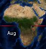
| Geography of Africa  FeatureType : null Elevation : 3 Lat/Lng : 37.3386 / 9.8367 | Africa is a continent comprising 63 political territories, representing the largest of the great southward projections from the main mass of Earth's surface. Within its regular outline, it comprises an area of , excluding adjacent islands (...) |
| 2 | 
| Appalachian Mountains FeatureType : mountain Elevation : 298 Lat/Lng : 40.0 / -78.0 | The Appalachian Mountains , often called the Appalachians, are a system of mountains in eastern North America. The Appalachians first formed roughly 480 million years ago during the Ordovician Period. They once reached elevations similar to those of the Alps and the Rocky Mountains before (...) |
| 3 | 
| Krakatoa FeatureType : mountain Elevation : 253 Lat/Lng : -6.1028 / 105.4231 | Krakatoa, or Krakatau , is a volcanic island situated in the Sunda Strait between the islands of Java and Sumatra in the Indonesian province of Lampung. The name is also used for the surrounding island group comprising the remnants of a much larger island of three volcanic peaks which was (...) |
| 4 | 
| Red Sea FeatureType : adm1st Lat/Lng : 20.1553 / 38.6469 | The Red Sea (also the Erythraean Sea) is a seawater inlet of the Indian Ocean, lying between Africa and Asia. The connection to the ocean is in the south through the Bab el Mandeb strait and the Gulf of Aden. To the north lie the Sinai Peninsula, the Gulf of Aqaba, and the Gulf of Suez (leading to (...) |
| 5 | 
| Marrakesh FeatureType : null Elevation : 459 Lat/Lng : 31.6353 / -8.0003 | Marrakesh (or ; Murrākuš; Meṛṛakec), also known by the French spelling Marrakech, is a major city of the Kingdom of Morocco. It is the fourth largest city in the country, after Casablanca, Fez and Tangier. It is the capital city of the mid-southwestern region of Marrakesh-Safi (...) |
| 6 | 
| Oman FeatureType : country Elevation : 129 Lat/Lng : 21.0 / 57.0 | Oman , officially the Sultanate of Oman , is an Arab country on the southeastern coast of the Arabian Peninsula in Western Asia. Its official religion is Islam. Holding a strategically important position at the mouth of the Persian Gulf, the country shares land borders with the United Arab Emirates (...) |
| 7 | 
| Antarctica FeatureType : null Lat/Lng : -69.3578 / -2.2472 | Antarctica (or) is Earth's southernmost continent. It contains the geographic South Pole and is situated in the Antarctic region of the Southern Hemisphere, almost entirely south of the Antarctic Circle, and is surrounded by the Southern Ocean. At , it is the fifth-largest continent (...) |
| 8 | 
| Aden FeatureType : null Elevation : 126 Lat/Lng : 12.7736 / 45.0265 | Aden (; ' Yemeni:) is a port city and the temporary capital of Yemen, located by the eastern approach to the Red Sea (the Gulf of Aden), some east of Bab-el-Mandeb. Its population is approximately 800,000 people (...) |
| 9 | 
| Terceira Island FeatureType : null Elevation : 580 Lat/Lng : 38.7222 / -27.2069 | Terceira is an island in the Azores archipelago, in the middle of the North Atlantic Ocean. It is one of the larger islands of the archipelago, with a population of 56,000 inhabitants in an area of approximately (...) |
| 10 | 
| Ngorongoro Conservation Area FeatureType : mountain Elevation : 2537 Lat/Lng : -3.2089 / 35.4628 | The Ngorongoro Conservation Area (NCA) is a protected area and a World Heritage Site located west of Arusha in the Crater Highlands area of Tanzania. The area is named after Ngorongoro Crater, a large volcanic caldera within the area (...) |
| 11 | 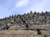
| Borobudur FeatureType : landmark Elevation : 272 Lat/Lng : -7.608 / 110.204 | Borobudur, or Barabudur is a 9th-century Mahayana Buddhist temple in Magelang Regency, not far from the town of Muntilan, in Central Java, Indonesia. It is the world's largest Buddhist temple. The temple consists of nine stacked platforms, six square and three circular, topped by a central dome (...) |
| 12 | 
| Saudi Arabia FeatureType : country Elevation : 943 Lat/Lng : 24.0 / 45.0 | Saudi Arabia , officially the Kingdom of Saudi Arabia (KSA; '), is a country in Western Asia constituting the bulk of the Arabian Peninsula. With a land area of approximately , Saudi Arabia is the largest sovereign state in the Middle East, geographically the fifth-largest in Asia, second-largest in (...) |
| 13 | 
| Aldershot FeatureType : null Elevation : 89 Lat/Lng : 51.247 / -0.7598 | Aldershot is a town in the Rushmoor district of Hampshire, England. It lies on heathland in the extreme northeast corner of the county, about southwest of London. The area is administered by Rushmoor Borough Council (...) |
| 14 | 
| Tabriz FeatureType : null Elevation : 1396 Lat/Lng : 38.08 / 46.2919 | Tabriz is the most populated city in Iranian Azerbaijan, one of the historical capitals of Iran and the present capital of East Azerbaijan province. Located in the Quru River valley, between long ridges of volcanic cones in the Sahand and Eynali mountains, Tabriz's elevation ranges between above sea (...) |
| 15 | 
| Edinburgh FeatureType : city Elevation : 129 Lat/Lng : 55.9496 / -3.1603 | Edinburgh is the capital city of Scotland and one of its 32 council areas. Historically part of the county of Midlothian (or Edinburghshire), it is located in Lothian on the Firth of Forth's southern shore. Recognised as the capital of Scotland since at least the 15th century, Edinburgh is the seat (...) |
| 16 | 
| Harz FeatureType : mountain Elevation : 719 Lat/Lng : 51.75 / 10.6333 | The Harz is a Mittelgebirge that has the highest elevations in Northern Germany and its rugged terrain extends across parts of Lower Saxony, Saxony-Anhalt, and Thuringia. The name Harz derives from the Middle High German word Hardt or Hart (hill forest), Latinized as Hercynia (...) |
| 17 | 
| Póvoa de Varzim FeatureType : city Elevation : 22 Lat/Lng : 41.4167 / -8.7667 | Póvoa de Varzim , also spelled Povoa de Varzim, is a Portuguese city in Northern Portugal and sub-region of Greater Porto. It sits in a sandy coastal plain, a cuspate foreland, halfway between the Minho and Douro rivers. In 2001, there were 63,470 inhabitants, with 42,396 living in the city proper (...) |
| 18 | 
| Lord Howe Island FeatureType : landmark Elevation : 61 Lat/Lng : -31.5531 / 159.0839 | Lord Howe Island (; formerly Lord Howe's Island) is an irregularly crescent-shaped volcanic remnant in the Tasman Sea between Australia and New Zealand, directly east of mainland Port Macquarie, northeast of Sydney, and about southwest of Norfolk Island (...) |
| 19 | 
| Sweden FeatureType : country Lat/Lng : 63.0 / 16.0 | Sweden , officially the Kingdom of Sweden (Swedish: Konungariket Sverige), is a Scandinavian Nordic country in Northern Europe. It borders Norway to the west and north and Finland to the east, and is connected to Denmark in the southwest by a bridge-tunnel across the Öresund, a strait at the (...) |
| 20 | 
| Malta FeatureType : country Elevation : 96 Lat/Lng : 35.9167 / 14.4333 | Malta , officially known as the Republic of Malta , is a Southern European island country consisting of an archipelago in the Mediterranean Sea. It lies south of Italy, east of Tunisia, and north of Libya. Malta is one of the world's smallest and most densely populated countries, at over with a (...) |
| 21 | 
| Richmond Park FeatureType : landmark Elevation : 26 Lat/Lng : 51.4494 / -0.2739 | Richmond Park, in the London Borough of Richmond upon Thames, was created by Charles I in the 17th century as a deer park. The largest of London's Royal Parks, it is of national and international importance for wildlife conservation (...) |
| 22 | 
| Paterson, New Jersey FeatureType : city Elevation : 35 Lat/Lng : 40.9147 / -74.1628 | Paterson is the largest city in and the county seat of Passaic County, New Jersey, United States., New Jersey Department of State. Accessed July 10, 2017. As of the 2010 United States Census, its population was 146,199, rendering it New Jersey's third-most-populous city (...) |
| 23 | 
| El Salvador FeatureType : country Elevation : 638 Lat/Lng : 13.6833 / -89.1833 | El Salvador , officially the Republic of El Salvador (literally "Republic of The Savior"), is the smallest and the most densely populated country in Central America. It is bordered on the northeast by Honduras, on the northwest by Guatemala, and on the south by the Pacific Ocean (...) |
| 24 | 
| Gaza City FeatureType : null Elevation : 47 Lat/Lng : 31.5167 / 34.45 | Gaza (;The New Oxford Dictionary of English (1998), , p. 761 "Gaza Strip /'gɑːzə/ a strip of territory in Palestine, on the SE Mediterranean coast including the town of Gaza...". ', ; Ancient Ġāzā), also referred to as Gaza City, is a Palestinian city in the Gaza Strip, with a population of 515,556, (...) |
| 25 | 
| St Kilda, Scotland FeatureType : isle Elevation : 267 Lat/Lng : 57.8178 / -8.5811 | St Kilda is an isolated archipelago situated west-northwest of North Uist, in the North Atlantic Ocean. It contains the westernmost islands of the Outer Hebrides of Scotland. The largest island is Hirta, whose sea cliffs are the highest in the United Kingdom (...) |
| 26 | 
| Madrid FeatureType : null Elevation : 700 Lat/Lng : 40.4333 / -3.6833 | Madrid is the capital of Spain and the largest municipality in both the Community of Madrid and Spain as a whole. The city has almost 3.2 million, Instituto Nacional de Estadística, 2015. inhabitants and a metropolitan area population of approximately 6.5 million (...) |
| 27 | 
| Iran FeatureType : country Elevation : 1188 Lat/Lng : 35.7 / 51.4167 | Iran , also known as Persia , officially the Islamic Republic of Iran , is a country in Western Asia. With over 81 million inhabitants, Iran is the world's 18th-most-populous country. Comprising a land area of , it is the second-largest country in the Middle East and the 17th-largest in the world (...) |
| 28 | 
| Îles des Saintes FeatureType : isle Lat/Lng : 15.8611 / -61.6098 | The Îles des Saintes ("Islands of the Saints"), also known as Les Saintes, is a small archipelago of the French Antilles (West Indies) located to the south of Basse-Terre Island, west of Marie-Galante and north of Dominica (...) |
| 29 | 
| Hemel Hempstead FeatureType : null Elevation : 109 Lat/Lng : 51.7526 / -0.4692 | Hemel Hempstead is a new town in Hertfordshire, England. Located northwest of London, it is part of the Greater London Urban Area. The population according to the 2001 Census was 81,143, and at the 2011 census was 94,932 (...) |
| 30 | Sinkhole FeatureType : null Elevation : 80 Lat/Lng : 52.1326 / -9.7459 | A sinkhole, also known as a cenote, sink, sink-hole, swallet, swallow hole, or doline (the different terms for sinkholes are often used interchangeably), is a depression or hole in the ground caused by some form of collapse of the surface layer (...) | |
| 31 | 
| Bairnsdale FeatureType : null Elevation : 5 Lat/Lng : -37.8167 / 147.6167 | Bairnsdale Macquarie Dictionary, Fourth Edition (2005). Melbourne, The Macquarie Library Pty Ltd. is a city in East Gippsland, Victoria, Australia. The estimated population of Bairnsdale urban area was 14,887 at June 2016 (...) |
| 32 | 
| Finedon FeatureType : null Elevation : 81 Lat/Lng : 52.334 / -0.6597 | Finedon is a small town in the Borough of Wellingborough, Northamptonshire, with a population at the 2011 census of 4,309 people.. Retrieved 15 July 2015 In 1086 when the Domesday Book was completed, Finedon (then known as Tingdene) was a large royal manor, previously held by Queen Edith, wife of (...) |
| 33 | Lagos, Portugal FeatureType : adm1st Elevation : 27 Lat/Lng : 37.1531 / -8.7362 | Lagos (literally lakes;) is a municipality at the mouth of Bensafrim River and along the Atlantic Ocean, in the Barlavento region of the Algarve, in southern Portugal.Detail Regional Map, Algarve-Southern Portugal, The population in 2011 was 31,049, in an area of 212.99 km² (...) | |
| 34 | Everglades FeatureType : null Elevation : 7 Lat/Lng : 26.0 / -80.7 | The Everglades is a natural region of tropical wetlands in the southern portion of the U.S. state of Florida, comprising the southern half of a large drainage basin and part of the neotropic ecozone. The system begins near Orlando with the Kissimmee River, which discharges into the vast but shallow (...) | |
| 35 | Lucerne FeatureType : null Elevation : 443 Lat/Lng : 47.0521 / 8.3059 | Lucerne (; ; ; ; ; Lucerne German: Lozärn) is a city in central Switzerland, in the German-speaking portion of the country. Lucerne is the capital of the canton of Lucerne and part of the district of the same name (...) | |
| 36 | East of England FeatureType : city Elevation : 36 Lat/Lng : 52.24 / 0.41 | The East of England is one of nine official regions of England at the first level of NUTS for statistical purposes. It was created in 1994 and was adopted for statistics from 1999. It includes the ceremonial counties of Bedfordshire, Cambridgeshire, Essex, Hertfordshire, Norfolk and Suffolk (...) | |
| 37 | Rogue River (Oregon) FeatureType : null Elevation : 0 Lat/Lng : 42.4225 / -124.4292 | The Rogue River (Tolowa: yan-shuu-chit’ taa-ghii~-li~’, Takelma: tak-elam) in southwestern Oregon in the United States flows about in a generally westward direction from the Cascade Range to the Pacific Ocean. Known for its salmon runs, whitewater rafting, and rugged scenery, it was one of the (...) | |
| 38 | Calvià FeatureType : null Elevation : 132 Lat/Lng : 39.5656 / 2.5072 | Calvià is a municipality on the island of Majorca, part of the Spanish autonomous community of the Balearic Islands. It is located in the southwestern part of the island of Majorca, between the Serra de Tramuntana and the Serra de Na Burguesa. The municipal seat is the town of Vila Calvia (...) | |
| 39 | Çukurova FeatureType : null Elevation : 9 Lat/Lng : 36.8667 / 35.4833 | Çukurova , alternatively known as Cilicia, is a geo-cultural region in south-central Turkey, covering the provinces of Mersin, Adana, Osmaniye and Hatay. With a population of almost 6 million, it is one of the largest population concentrations in Turkey (...) | |
| 40 | Antarctic minke whale FeatureType : null Lat/Lng : 78.0333 / 11.7167 | The Antarctic minke whale or southern minke whale (Balaenoptera bonaerensis) is a species of minke whale within the suborder of baleen whales. It is the second smallest rorqual after the common minke whale and the third smallest baleen whale (...) | |
| 41 | Newcastle-under-Lyme FeatureType : null Elevation : 132 Lat/Lng : 53.0109 / -2.2278 | Newcastle-under-Lyme (locally ; or Underlem , cf. Burslem, Audlem), is a market town in Staffordshire, England, and is the principal settlement in the Borough of Newcastle-under-Lyme. In the 2011 census the town had a population of 128,264.Newcastle is made up of 14 wards http://www.ukcensusdata (...) | |
| 42 | 1883 eruption of Krakatoa FeatureType : mountain Elevation : 679 Lat/Lng : -6.1461 / 105.4428 | The 1883 eruption of Krakatoa in the Dutch East Indies (now Indonesia) began in the afternoon of Sunday, 26 August 1883 (with origins as early as May of that year), and peaked in the late morning of Monday, 27 August when over 70% of the island and its surrounding archipelago were destroyed as it (...) | |
| 43 | Great Rift Valley, Kenya FeatureType : landmark Elevation : 2359 Lat/Lng : -0.0765 / 36.2121 | The Great Rift Valley is part of an intra-continental ridge system that runs through Kenya from north to south. It is part of the Gregory Rift, the eastern branch of the East African Rift, which starts in Tanzania to the south and continues northward into Ethiopia (...) | |
| 44 | Canzo FeatureType : null Elevation : 387 Lat/Lng : 45.85 / 9.2667 | Canzo (; , Canzés: , Milanese:)See: Languages in Canzo. is a comune (municipality) of the Italian province of Como. It is the last town north of the historical Brianza region of Lombardy, capital of the Lake Como Triangle community and a regional tourism destination (...) | |
| 45 | Serbia FeatureType : country Elevation : 487 Lat/Lng : 43.95 / 20.9333 | Serbia (/ Srbija),Pannonian Rusyn: ; ; Albanian and Romanian: ; Slovak and Czech: , ; . officially the Republic of Serbia (/ Republika Srbija), is a country situated at the crossroads of Central and Southeast Europe in the southern Pannonian Plain and the central Balkans (...) | |
| 46 | Douglas DC-3 FeatureType : null Lat/Lng : -74.0822 / 10.9078 | The Douglas DC-3 is a fixed-wing propeller-driven airliner that revolutionized air transport in the 1930s and 1940s. Its lasting effect on the airline industry and World War II makes it one of the most significant transport aircraft ever produced (...) | |
| 47 | Killarney National Park FeatureType : null Elevation : 22 Lat/Lng : 51.9933 / -9.5572 | Killarney National Park , near the town of Killarney, County Kerry, was the first national park in Ireland, created when Muckross Estate was donated to the Irish Free State in 1932. The park has since been substantially expanded and encompasses over 102 (...) | |
| 48 | Atlantis FeatureType : null Lat/Lng : 35.2542 / -24.2585 | Atlantis ("island of Atlas") is a fictional island mentioned within an allegory on the hubris of nations in Plato's works Timaeus and Critias, where it represents the antagonist naval power that besieges "Ancient Athens", the pseudo-historic embodiment of Plato's ideal state in The Republic (...) | |
| 49 | Ganoga Lake FeatureType : null Elevation : 692 Lat/Lng : 41.3561 / -76.3183 | Ganoga Lake is a natural lake in Colley Township in southeastern Sullivan County in Pennsylvania, United States. Known as Robinson's Lake and Long Pond for most of the 19th century, the lake was purchased by the Ricketts family in the early 1850s and became part of R (...) | |
| 50 | Retford FeatureType : null Elevation : 19 Lat/Lng : 53.3169 / -0.9408 | Retford (pronounced rɛt-fʌd, RET-fud) is a market town in Nottinghamshire in the East Midlands of England, from Nottingham, and west of Lincoln. The population at the 2011 census was 22,013. The town is in the valley of the River Idle and the Chesterfield Canal passes through the centre (...) | |
| 51 | Canton, Michigan FeatureType : null Elevation : 3174 Lat/Lng : 42.3125 / 83.475 | Canton, officially the Charter Township of Canton, is a charter township of Wayne County in the U.S. state of Michigan. It is located about west of the city limits of Detroit and east of the city limits of Ann Arbor (...) | |
| 52 | Paraíso, Tabasco FeatureType : null Elevation : 8 Lat/Lng : 18.4012 / -93.2141 | Paraíso is a town and municipality located in the north of the Mexican state of Tabasco, about 75 km due north of the state capital of Villahermosa on the Gulf of Mexico. Much of the area is traditionally dedicated to fishing and agriculture (...) | |
| 53 | Tryon Creek FeatureType : null Elevation : 4 Lat/Lng : 45.4228 / -122.6567 | Tryon Creek is a tributary of the Willamette River in the U.S. state of Oregon. Part of the drainage basin of the Columbia River, its watershed covers about in Multnomah and Clackamas counties. The stream flows southeast from the Tualatin Mountains (West Hills) through the Multnomah Village (...) | |
| 54 | Louisiana State Penitentiary FeatureType : city Elevation : 20 Lat/Lng : 30.9506 / -91.5692 | The Louisiana State Penitentiary (known as Angola, and nicknamed the "Alcatraz of the South" and "The Farm"Sutton, Keith "Catfish". "". ESPN Outdoors. May 31, 2006. Retrieved on August 25, 2010.) is a maximum-security prison farm in Louisiana operated by the Louisiana Department of Public Safety & (...) | |
| 55 | Worlds End State Park FeatureType : null Elevation : 368 Lat/Lng : 41.4714 / -76.5686 | Worlds End State Park is a Pennsylvania state park in Sullivan County, Pennsylvania, in the United States. The park, nearly surrounded by Loyalsock State Forest, is in the Loyalsock Creek valley on Pennsylvania Route 154, in Forks and Shrewsbury Townships southeast of the borough of Forksville (...) | |
| 56 | Clarens, Free State FeatureType : null Elevation : 2022 Lat/Lng : -28.51 / 28.41 | Clarens is a small town situated in the foothills of the Maluti Mountains in the Free State province of South Africa and nicknamed the "Jewel of the Eastern Free State". It was established in 1912 and named after the town of Clarens in Switzerland where exiled Paul Kruger spent his last days (...) | |
| 57 | Nuclear and radiation accidents and incidents FeatureType : landmark Elevation : 246 Lat/Lng : 55.7125 / 60.8481 | A nuclear and radiation accident is defined by the International Atomic Energy Agency (IAEA) as "an event that has led to significant consequences to people, the environment or the facility." Examples include lethal effects to individuals, radioactive isotope to the environment, or reactor core melt (...) | |
| 58 | Melkhoutboom Cave FeatureType : null Elevation : 177 Lat/Lng : -33.3167 / 25.2833 | Melkhoutboom Cave is an archaeological site dating to the Later Stone Age, located in the Zuurberg Mountains, Cape Folded Mountain Belt, Sarah Baartman District Municipality in the Eastern Cape Province of South Africa. (...) | |
| 59 | Deriba (caldera) FeatureType : null Elevation : 2223 Lat/Lng : 12.95 / 24.27 | Deriba is a Pleistocene or Holocene caldera in Darfur, Sudan. Part of the volcanoes of the Marra Mountains, it lies on the Darfur dome and like the Tagabo Hills and Meidob Hills volcanism may be the consequence of a mantle plume (...) | |
| 60 | Geography of Newfoundland and Labrador FeatureType : null Lat/Lng : 51.0 / -57.0 | Newfoundland and Labrador is the easternmost province in Canada. The Strait of Belle Isle separates the province into two geographical divisions, Labrador and the island of Newfoundland. The province also includes over seven thousand small islands (...) | |
| 61 | Geography of Sudan FeatureType : country Elevation : 505 Lat/Lng : 15.0 / 30.0 | Sudan is located in northeastern Africa. It is bordered by Egypt to the north, the Red Sea to the northeast, Eritrea and Ethiopia to the east, South Sudan to the south, the Central African Republic to the southwest, Chad to the west and Libya to the northwest (...) | |
| 62 | Kamfers Dam FeatureType : waterbody Elevation : 1160 Lat/Lng : -28.6728 / 24.7633 | Kamfers Dam is a privately owned permanent water body of 400 ha, situated to the immediate north of Kimberley, South Africa. The wetland was originally an ephemeral pan, often dry and dependent on rain water. In recent times its water level rose due to the input of constant runoff and treated water (...) | |
| 63 | Telegraph Island FeatureType : landmark Elevation : 8 Lat/Lng : 26.1953 / 56.3428 | Telegraph Island (also known as Jazīrat al Maqlab or جزيرة_تليغراف, and Jazīrat Şaghīr) is located in the Elphinstone Inlet or Khor Ash Sham, the inner inlet of Khasab Bay, less than 400 meters off the shore of the Musandam Peninsula, and less than 500 meters south of much larger but also much (...) | |
| 64 | Art collections of Holkham Hall FeatureType : null Elevation : 21 Lat/Lng : 52.9494 / 0.8073 | The art collection of Holkham Hall in Norfolk, England remains very largely that which the original owner intended the house to display; the house was designed around the art collection acquired (a few works were commissioned) by Thomas Coke 1st Earl of Leicester during his Grand Tour of Italy (...) | |
| 65 | History of the United States Coast Guard FeatureType : null Lat/Lng : 52.65 / 167.4 | The history of the United States Coast Guard goes back to the United States Revenue Cutter Service, which was founded on 4 August 1790 as part of the Department of the Treasury. The Revenue Cutter Service and the United States Life-Saving Service were merged to become the Coast Guard per which (...) | |
| 66 | Quehanna Wild Area FeatureType : null Elevation : 598 Lat/Lng : 41.2742 / -78.2567 | Quehanna Wild Area is a wildlife area within parts of Cameron, Clearfield and Elk counties in the U.S. state of Pennsylvania; with a total area of , it covers parts of Elk and Moshannon State Forests. Founded in the 1950s as a nuclear research center, Quehanna has a legacy of radioactive and toxic (...) | |
| 67 | Red (disambiguation) FeatureType : null Elevation : -4 Lat/Lng : 36.9763 / -122.1419 | Red is a color. Red or RED may also refer to: (...) | |
| 68 | Waw an Namus FeatureType : null Elevation : 393 Lat/Lng : 24.9128 / 17.7564 | Waw an Namus (also spelled Wau-en-Namus) is a volcano in Libya. Of either Pleistocene or Holocene age, it is located within the eastern Fezzan region. The origin of the volcanism there and at Al Haruj farther north is not clear (...) | |
| 69 | Chibuene FeatureType : city Lat/Lng : -22.0333 / 35.325 | Chibuene is a Mozambiquean archaeological site, located five kilometres south of the coastal city of Vilanculos South Beach. The site was occupied during two distinct phases. The earlier phase of occupation dates to the late first millennium AD (...) | |
| 70 | Mbam Djerem National Park FeatureType : landmark Elevation : 749 Lat/Lng : 5.8473 / 12.7746 | The Mbam Djerem National Park is found in Cameroon. It was established in 2000 and covers 4234.78 km². (...) | |
 by
by