| 425 records found in wikipedia | |||
| 1 | 
| The Championships, Wimbledon  FeatureType : landmark Elevation : 30 Lat/Lng : 51.4337 / -0.214 | The Championships, Wimbledon, commonly known simply as Wimbledon, is the oldest tennis tournament in the world. It has been held at the All England Club in Wimbledon, London, since 1877 and is played on outdoor grass courts (...) |
| 2 | 
| Weddell Sea FeatureType : waterbody Lat/Lng : -75.0494 / -47.2628 | The Weddell Sea is part of the Southern Ocean and contains the Weddell Gyre. Its land boundaries are defined by the bay formed from the coasts of Coats Land and the Antarctic Peninsula. The easternmost point is Cape Norvegia at Princess Martha Coast, Queen Maud Land (...) |
| 3 | 
| Manchester Airport FeatureType : landmark Elevation : 76 Lat/Lng : 53.3537 / -2.2749 | Manchester Airport (Occasionally referred to as Manchester Ringway International Airport) is an international airport in Ringway, Greater Manchester, England, south-west of Manchester city centre. In 2016, it was the third busiest airport in the United Kingdom in terms of passenger numbers and the (...) |
| 4 | 
| Dartmoor FeatureType : landmark Elevation : 394 Lat/Lng : 50.5719 / -3.9207 | Dartmoor is a moor in southern Devon, England. Protected by National Park status as Dartmoor National Park, it covers . The granite which forms the uplands dates from the Carboniferous Period of geological history (...) |
| 5 | 
| British Library FeatureType : landmark Elevation : 27 Lat/Lng : 51.5294 / -0.1269 | The British Library is the national library of the United Kingdom. British Library. Retrieved on 17 April 2014. and the largest national library in the world by number of items catalogued. It is estimated to contain 150–200 million+ items from many countries (...) |
| 6 | 
| Shetland FeatureType : adm1st Lat/Lng : 60.3038 / -1.2689 | Shetland , also called the Shetland Islands and formerly Zetland, is a subarctic archipelago of Scotland that lies northeast of Great Britain. The islands lie some to the northeast of Orkney, from the Scottish mainland and southeast of the Faroe Islands (...) |
| 7 | 
| St Kilda, Scotland FeatureType : isle Elevation : 267 Lat/Lng : 57.8178 / -8.5811 | St Kilda is an isolated archipelago situated west-northwest of North Uist, in the North Atlantic Ocean. It contains the westernmost islands of the Outer Hebrides of Scotland. The largest island is Hirta, whose sea cliffs are the highest in the United Kingdom (...) |
| 8 | 
| Ben Nevis FeatureType : mountain Elevation : 1335 Lat/Lng : 56.7969 / -5.0035 | Ben Nevis is the highest mountain in the British Isles. Standing at above sea level, it is at the western end of the Grampian Mountains in the Lochaber area of the Scottish Highlands, close to the town of Fort William (...) |
| 9 | 
| Jura, Scotland FeatureType : isle Lat/Lng : 55.9596 / -5.9113 | Jura is an island in the Inner Hebrides of Scotland, adjacent to and to the north-east of Islay. With an area of 36,692 hectares, or 142 square miles, and only 196 inhabitants recorded in the 2011 census, Jura is much more sparsely populated than neighbouring Islay, and is one of the least densely (...) |
| 10 | 
| Isle of Lewis FeatureType : isle Elevation : 93 Lat/Lng : 58.1918 / -6.6022 | Lewis is the northern part of Lewis and Harris, the largest island of the Western Isles or Outer Hebrides archipelago in Scotland. It is also known as the Isle of Lewis, as the two parts are frequently referred to as if they were separate islands. The total area of Lewis is (...) |
| 11 | 
| Isles of Scilly FeatureType : isle Elevation : 23 Lat/Lng : 49.9212 / -6.2943 | The Isles of Scilly (; or ') is an archipelago off the southwestern tip of Cornwall. One of the islands, St Agnes, is the most southerly point in both England and the United Kingdom, being over further south than the most southerly point of the British mainland at Lizard Point (...) |
| 12 | 
| London Stansted Airport FeatureType : airport Elevation : 100 Lat/Lng : 51.8903 / 0.2386 | London Stansted Airport is an international airport located at Stansted Mountfitchet in the district of Uttlesford in Essex, northeast of Central London and from the Hertfordshire border. London Stansted currently serves over 170 destinations across Europe, North Africa, Western Asia, with more (...) |
| 13 | 
| Bournemouth FeatureType : null Elevation : 21 Lat/Lng : 50.7178 / -1.8794 | Bournemouth is a large coastal resort town on the south coast of England to the east of the Jurassic Coast, a World Heritage Site, long. According to the 2011 census, the town has a population of 183,491 making it the largest settlement in Dorset (...) |
| 14 | 
| Rockall FeatureType : isle Elevation : 0 Lat/Lng : 57.5963 / -13.6873 | Rockall is a British uninhabited granite islet located within the exclusive economic zone (EEZ) of the United Kingdom,. Oireachtas, Dublin, 24 March 2011. Retrieved 5 April 2018. situated in the North Atlantic Ocean (...) |
| 15 | 
| Exmoor FeatureType : landmark Elevation : 318 Lat/Lng : 51.1067 / -3.6114 | Exmoor is loosely defined as an area of hilly open moorland in west Somerset and north Devon in South West England. It is named after the River Exe, the source of which is situated in the centre of the area, two miles north-west of Simonsbath (...) |
| 16 | 
| Whitby FeatureType : null Elevation : 37 Lat/Lng : 54.4858 / -0.6206 | Whitby is a seaside town, port and civil parish in the Scarborough borough of North Yorkshire, England. Situated on the east coast of Yorkshire at the mouth of the River Esk, Whitby has a maritime, mineral and tourist heritage (...) |
| 17 | 
| London Borough of Croydon FeatureType : adm1st Elevation : 153 Lat/Lng : 51.3333 / -0.0833 | The London Borough of Croydon (pronunciation) is a London borough in south London, England and is part of Outer London. It covers an area of and is the largest London borough by population. It is the southernmost borough of London (...) |
| 18 | 
| Orkney FeatureType : isle Elevation : 29 Lat/Lng : 59.0 / -3.0 | Orkney , also known as the Orkney Islands, is an archipelago in the Northern Isles of Scotland, situated off the north coast of Great Britain. Orkney is 16 kilometres (10 mi) north of the coast of Caithness and comprises approximately 70 islands, of which 20 are inhabited.Haskell-Smith (2004) pp (...) |
| 19 | 
| Parthenon FeatureType : landmark Elevation : 146 Lat/Lng : 37.9715 / 23.7267 | The Parthenon (; ; , Parthenónas) is a former temple on the Athenian Acropolis, Greece, dedicated to the goddess Athena, whom the people of Athens considered their patron. Construction began in 447 BC when the Athenian Empire was at the peak of its power (...) |
| 20 | 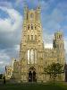
| Ely, Cambridgeshire FeatureType : null Elevation : 21 Lat/Lng : 52.3996 / 0.262 | Ely is a cathedral city in Cambridgeshire, England, about north-northeast of Cambridge and about by road from London. Æthelthryth (also known as Etheldreda) founded an abbey at Ely in 673; the abbey was destroyed in 870 by Danish invaders and was rebuilt by Æthelwold, Bishop of Winchester, in 970 (...) |
| 21 | 
| Agartala FeatureType : null Elevation : 15 Lat/Lng : 23.8308 / 91.2825 | Agartala (Bengali: আগরতলা, ') is the capital of the Indian state of Tripura and second largest city in North-east India after Guwahati, both in municipal area and population. The city is the seat of the Government of Tripura. Agartala is one of the fastest developing cities of India (...) |
| 22 | 
| Birmingham FeatureType : city Elevation : 141 Lat/Lng : 52.4831 / -1.8936 | Birmingham is the second-most populous city in the United Kingdom, after London, and the most populous city in the English Midlands. With an estimated population of 1,137,100 , Birmingham is the cultural, social, financial and commercial centre of the Midlands (...) |
| 23 | 
| Derry FeatureType : null Elevation : 30 Lat/Lng : 54.9958 / -7.3074 | Derry, officially Londonderry , is the second-largest city in Northern Ireland and the fourth-largest city on the island of Ireland.. Retrieved 1 November 2008. The name Derry is an anglicisation of the Old Irish name Daire (modern Irish: Doire) meaning "oak grove" (...) |
| 24 | 
| Ireland FeatureType : country Elevation : 109 Lat/Lng : 53.4622 / -7.7625 | Ireland (; ; Ulster-Scots:) is an island in the North Atlantic. It is separated from Great Britain to its east by the North Channel, the Irish Sea, and St George's Channel. Ireland is the second-largest island of the British Isles, the third-largest in Europe, and the twentieth-largest on Earth (...) |
| 25 | 
| Kingston upon Hull FeatureType : city Elevation : 11 Lat/Lng : 53.7443 / -0.3325 | Kingston upon Hull, usually abbreviated to Hull, is a port city and unitary authority in the East Riding of Yorkshire, England. It lies upon the River Hull at its confluence with the Humber Estuary, 25 miles (40 km) inland from the North Sea, with a population of (...) |
| 26 | 
| Iquitos FeatureType : city Elevation : 101 Lat/Lng : -3.7551 / -73.2491 | Iquitos , also known as Iquitos City, is the capital city of Peru's Maynas Province and Loreto Region. The largest metropolis in the Peruvian Amazon, east of the Andes, it is the sixth most populous city of Peru. It is known as the "capital of the Peruvian Amazon" (...) |
| 27 | 
| Fair Isle FeatureType : isle Elevation : 129 Lat/Lng : 59.542 / -1.622 | Fair Isle (IPA: /fɛəraɪ̯l/; ;) is an island in Shetland, in northern Scotland. It lies about halfway between mainland Shetland and Orkney. It is known for its bird observatory and a traditional style of knitting. (...) |
| 28 | 
| Milford Sound FeatureType : null Elevation : 12 Lat/Lng : -44.6374 / 167.9016 | Milford Sound / Piopiotahi is a fiord in the south west of New Zealand's South Island within Fiordland National Park, Piopiotahi (Milford Sound) Marine Reserve, and the Te Wahipounamu World Heritage site. It has been judged the world's top travel destination in an international survey (the 2008 (...) |
| 29 | 
| Mainland, Orkney FeatureType : isle Elevation : 87 Lat/Lng : 58.9833 / -3.1 | The Mainland is the main island of Orkney, Scotland. Both of Orkney's burghs, Kirkwall and Stromness, lie on the island, which is also the heart of Orkney's ferry and air connections. Seventy-five per cent of Orkney's population live on the island, which is more densely populated than the other (...) |
| 30 | 
| Sellafield FeatureType : landmark Elevation : 26 Lat/Lng : 54.4205 / -3.4975 | Sellafield is a nuclear fuel reprocessing and nuclear decommissioning site, close to the village of Seascale on the coast of the Irish Sea in Cumbria, England. The site is served by Sellafield railway station. Sellafield incorporates the original nuclear reactor site at Windscale, which is currently (...) |
| 31 | 
| Broadstairs FeatureType : null Elevation : 26 Lat/Lng : 51.3564 / 1.4392 | Broadstairs is a coastal town on the Isle of Thanet in the Thanet district of east Kent, England, about east of London. It is part of the civil parish of Broadstairs and St Peter's, which includes St Peter's, and had a population in 2011 of about 25,000 (...) |
| 32 | 
| Gosport FeatureType : null Elevation : 7 Lat/Lng : 50.7948 / -1.1243 | Gosport is a town in Hampshire on the south coast of England. At the 2011 Census, its population was 82,622. On a peninsula on the western side of Portsmouth Harbour, opposite the city of Portsmouth, it is linked to it by the Gosport Ferry. (...) |
| 33 | 
| Coll FeatureType : isle Elevation : 26 Lat/Lng : 56.6333 / -6.5572 | Coll Mac an Tàilleir (2003) p. 31 is an island located west of Mull in the Inner Hebrides of Scotland. Coll is known for its sandy beaches, which rise to form large sand dunes, for its corncrakes, and for Breacachadh Castle. It is in the council area of Argyll and Bute. (...) |
| 34 | 
| Herne Bay, Kent FeatureType : null Elevation : 8 Lat/Lng : 51.3706 / 1.127 | Herne Bay is a seaside town in Kent, South East England, with a population of 38,563. On the south coast of the Thames Estuary, it is north of Canterbury and east of Whitstable. It neighbours the ancient villages of Herne and Reculver and is part of the City of Canterbury local government district (...) |
| 35 | 
| Rùm FeatureType : isle Elevation : 226 Lat/Lng : 56.9996 / -6.3344 | Rùm , a Scottish Gaelic name often anglicised to Rum, is one of the Small Isles of the Inner Hebrides, in the district of Lochaber, Scotland. For much of the 20th century the name became Rhum, a spelling invented by the former owner, Sir George Bullough, because he did not relish the idea of having (...) |
| 36 | 
| Eigg FeatureType : isle Elevation : 73 Lat/Lng : 56.9038 / -6.155 | Eigg is one of the Small Isles, in the Scottish Inner Hebrides. It lies to the south of the Skye and to the north of the Ardnamurchan peninsula. Eigg is long from north to south, and east to west. With an area of , it is the second largest of the Small Isles after Rùm (...) |
| 37 | 
| Mallaig FeatureType : city Elevation : 5 Lat/Lng : 57.0061 / -5.8292 | Mallaig is a port in Lochaber, on the west coast of the Highlands of Scotland. The local railway station, Mallaig, is the terminus of the West Highland railway line (Fort William and Mallaig branch), completed in 1901, and the town is linked to Fort William by the A830 road – the "Road to the (...) |
| 38 | 
| Cairnryan FeatureType : null Elevation : 18 Lat/Lng : 54.971 / -5.018 | Cairnryan is a small village in the historical county of Wigtownshire, Scotland. It lies on the Eastern shore of Loch Ryan, north of Stranraer. The village is important in maritime history, with two ferry services connecting Scotland and Northern Ireland. (...) |
| 39 | 
| Foula FeatureType : isle Lat/Lng : 60.1333 / -2.0667 | Foula (pronounced //) in the Shetland archipelago of Scotland, is one of the United Kingdom’s most remote permanently inhabited islands. Owned since the turn of the 20th century by the Holbourn family, the island was the location for the film The Edge of the World (...) |
| 40 | 
| Durness FeatureType : city Elevation : 42 Lat/Lng : 58.568 / -4.746 | Durness is a village and civil parish in the north-west Highlands of Scotland. It lies on the north coast of the country in the traditional county of Sutherland, around north of Inverness. The area is remote, and the parish is huge and sparsely populated, covering an area from east of Loch Eriboll (...) |
| 41 | 
| Adam Air Flight 574 FeatureType : event Lat/Lng : -3.6789 / 118.1511 | Adam Air Flight 574 (KI574 or DHI574) was a scheduled domestic passenger flight operated by Adam Air between the Indonesian cities of Surabaya and Manado that broke up in mid-air and crashed into the Makassar Strait near Polewali in Sulawesi on 1 January 2007 (...) |
| 42 | 
| Gigha FeatureType : isle Elevation : -2 Lat/Lng : 55.6833 / -5.7667 | Gigha is a small island off the west coast of Kintyre in Scotland. The island forms part of Argyll and Bute and has a population of about 160 people. The climate is mild with higher than average sunshine hours and the soils are fertile. Gigha has been inhabited continuously since prehistoric times (...) |
| 43 | 
| Durham Tees Valley Airport FeatureType : null Elevation : 34 Lat/Lng : 54.5092 / -1.4294 | Durham Tees Valley Airport is an international airport located just east of Darlington in County Durham, north-east England, about south-west of Middlesbrough and south of Durham. The airport serves the North East and North Yorkshire, and is situated close to the village of Middleton St George in (...) |
| 44 | 
| Harris, Scotland FeatureType : isle Elevation : 125 Lat/Lng : 57.9022 / -6.8971 | Harris is the southern and more mountainous part of Lewis and Harris, the largest island in the Outer Hebrides, Scotland. Although not an island itself, Harris is often referred to as the Isle of Harris, which is the former postal county and the current post town for Royal Mail postcodes starting (...) |
| 45 | 
| Tintagel Castle FeatureType : landmark Elevation : 48 Lat/Lng : 50.6687 / -4.7619 | Tintagel Castle (meaning "fort of the constriction") is a medieval fortification located on the peninsula of Tintagel Island adjacent to the village of Tintagel, North Cornwall in the United Kingdom. The site was possibly occupied in the Romano-British period, as an array of artefacts dating to this (...) |
| 46 | 
| RAF Leuchars FeatureType : airport Elevation : 9 Lat/Lng : 56.3731 / -2.8686 | Royal Air Force Leuchars or RAF Leuchars was a Royal Air Force station located in Leuchars, Fife, on the east coast of Scotland. Throughout the Cold War and beyond, the station was home to fighter aircraft which policed northern UK airspace (...) |
| 47 | 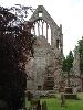
| Dryburgh Abbey FeatureType : landmark Elevation : 70 Lat/Lng : 55.5747 / -2.6497 | Dryburgh Abbey, near Dryburgh on the banks of the River Tweed in the Scottish Borders, was nominally founded on 10 November (Martinmas) 1150 in an agreement between Hugh de Morville, Constable of Scotland, and the Premonstratensian canons regular from Alnwick Abbey in Northumberland.Chron (...) |
| 48 | 
| St Patrick's Cathedral, Dublin FeatureType : landmark Elevation : 13 Lat/Lng : 53.3394 / -6.2714 | Saint Patrick's Cathedral in Dublin, Ireland, founded in 1191, is the National Cathedral of the Church of Ireland. With its spire, St. Patrick's is the tallest church (not Cathedral) in Ireland and the largest. Christ Church Cathedral, also a Church of Ireland cathedral in Dublin, is designated as (...) |
| 49 | 
| Eriskay FeatureType : null Elevation : 82 Lat/Lng : 57.0727 / -7.2908 | Eriskay , from the Old Norse for "Eric's Isle", is an island and community council area of the Outer Hebrides in northern Scotland. It lies between South Uist and Barra and is connected to South Uist by a causeway which was opened in 2001 (...) |
| 50 | German South West Africa FeatureType : landmark Elevation : 1665 Lat/Lng : -22.57 / 17.0836 | German South West Africa was a colony of the German Empire from 1884 until 1919. With an area of 835,100 km², it was one and a half times the size of the mainland German Empire in Europe at the time. The colony had a population of around 2,600 Germans (...) | |
| 51 | 
| Banqueting House, Whitehall FeatureType : landmark Elevation : 15 Lat/Lng : 51.5044 / -0.1256 | The Banqueting House, Whitehall, is the grandest and best known survivor of the architectural genre of banqueting house and the only remaining component of the Palace of Whitehall. The building is important in the history of English architecture as the first structure to be completed in the (...) |
| 52 | Apple Inc. FeatureType : landmark Elevation : 69 Lat/Lng : 37.3318 / -122.0312 | Apple Inc. is an American multinational technology company headquartered in Cupertino, California, that designs, develops, and sells consumer electronics, computer software, and online services. The company's hardware products include the iPhone smartphone, the iPad tablet computer, the Mac personal (...) | |
| 53 | Scottish Highlands FeatureType : null Elevation : 80 Lat/Lng : 57.12 / -4.71 | The Highlands (; , "the place of the Gaels") is a historic region of Scotland. Culturally, the Highlands and the Lowlands diverged from the later Middle Ages into the modern period, when Lowland Scots replaced Scottish Gaelic throughout most of the Lowlands (...) | |
| 54 | 
| Kentmere FeatureType : city Elevation : 256 Lat/Lng : 54.4484 / -2.8426 | Kentmere is a valley, village and civil parish in the Lake District National Park, a few miles from Kendal in the South Lakeland district of Cumbria, England. Historically in Westmorland, the parish has a population of 159 as of the 2011 Census. (...) |
| 55 | Inner Hebrides FeatureType : isle Elevation : 28 Lat/Lng : 56.5 / -6.0 | The Inner Hebrides (; Scottish Gaelic: Na h-Eileanan a-staigh, "the inner isles") is an archipelago off the west coast of mainland Scotland, to the south east of the Outer Hebrides. Together these two island chains form the Hebrides, which experience a mild oceanic climate (...) | |
| 56 | 
| Raasay FeatureType : isle Elevation : 75 Lat/Lng : 57.3833 / -6.0667 | Raasay is an island between the Isle of Skye and the mainland of Scotland. It is separated from Skye by the Sound of Raasay and from Applecross by the Inner Sound. It is most famous for being the birthplace of Gaelic poet Sorley MacLean, an important figure in the Scottish Renaissance (...) |
| 57 | AOL FeatureType : landmark Elevation : 47 Lat/Lng : 40.7308 / -73.9914 | AOL (stylized as Aol., formerly a company known as AOL Inc. and originally known as America Online) is a web portal and online service provider based in New York City. It is a brand marketed by Oath, a subsidiary of Verizon Communications (...) | |
| 58 | Curiosity (rover) FeatureType : null Elevation : 81 Lat/Lng : -4.5895 / 137.4417 | Curiosity is a car-sized rover designed to explore Gale Crater on Mars as part of NASA's Mars Science Laboratory mission (MSL). Curiosity was launched from Cape Canaveral on November 26, 2011, at 15:02 UTC aboard the MSL spacecraft and landed on Aeolis Palus in Gale Crater on Mars on August 6, 2012, (...) | |
| 59 | Kirklees FeatureType : null Elevation : 195 Lat/Lng : 53.593 / -1.801 | Kirklees is a local government district of West Yorkshire, England, governed by Kirklees Council with the status of a metropolitan borough. The largest town and administrative centre of Kirklees is Huddersfield, and the district also includes Batley, Birstall, Cleckheaton, Denby Dale, Dewsbury, (...) | |
| 60 | River Clyde FeatureType : waterbody Lat/Lng : 55.6795 / -4.9713 | The River Clyde is a river that flows into the Firth of Clyde in Scotland. It is the eighth-longest river in the United Kingdom, and the second-longest in Scotland. Traveling through the major city of Glasgow, it was an important river for shipbuilding and trade in the British Empire (...) | |
| 61 | 
| Mingulay FeatureType : isle Elevation : 176 Lat/Lng : 56.8059 / -7.642 | Mingulay is the second largest of the Bishop's Isles in the Outer Hebrides of Scotland. Located south of Barra, it is known for its important seabird populations, including puffins, black-legged kittiwakes, and razorbills, which nest in the sea-cliffs,Murray (1973) p. 102 (...) |
| 62 | Outer Hebrides FeatureType : isle Elevation : 1 Lat/Lng : 57.76 / -7.02 | The Outer Hebrides , also known as the Western Isles (or '), ' ("islands of the strangers") or the Long Isle or the Long Island , is an island chain off the west coast of mainland Scotland. The islands are geographically with , one of the 32 unitary council areas of Scotland (...) | |
| 63 | Nintendo FeatureType : landmark Elevation : 26 Lat/Lng : 34.9697 / 135.7562 | Nintendo Co., Ltd. is a Japanese multinational consumer electronics and video game company headquartered in Kyoto. Nintendo is one of the world's largest video game companies by market capitalization, creating some of the best-known and top-selling video game franchises, such as Mario, The Legend of (...) | |
| 64 | Intel FeatureType : landmark Elevation : 9 Lat/Lng : 37.3879 / -121.9635 | Intel Corporation (commonly known as Intel and stylized as intel) is an American multinational corporation and technology company headquartered in Santa Clara, California, in the Silicon Valley. It is the world's second largest and second highest valued semiconductor chip maker based on revenue (...) | |
| 65 | Aberdeen F.C. FeatureType : null Elevation : 3 Lat/Lng : 57.1425 / -2.0889 | Aberdeen Football Club (also known as The Dons) is a Scottish professional football club based in Aberdeen, Scotland. They compete in the Scottish Premiership and have never been relegated from the top division of the Scottish football league system since they were promoted in 1905, despite twice (...) | |
| 66 | Battle of Culloden FeatureType : event Elevation : 34 Lat/Lng : 57.4912 / -4.1322 | The Battle of Culloden was the final confrontation of the Jacobite rising of 1745. On 16 April 1746, the Jacobite forces of Charles Edward Stuart were decisively defeated by Hanoverian forces commanded by William Augustus, Duke of Cumberland, near Inverness in the Scottish Highlands (...) | |
| 67 | Mars Science Laboratory FeatureType : airport Elevation : 81 Lat/Lng : -4.5895 / 137.4417 | Mars Science Laboratory (MSL) is a robotic space probe mission to Mars launched by NASA on November 26, 2011, which successfully landed Curiosity, a Mars rover, in Gale Crater on August 6, 2012. The overall objectives include investigating Mars' habitability, studying its climate and geology, and (...) | |
| 68 | East Riding of Yorkshire FeatureType : adm2nd Elevation : 10 Lat/Lng : 53.8454 / -0.4275 | The East Riding of Yorkshire, or simply East Riding, is an area in Northern England and can refer either to the administrative county (Local Government Area) of the East Riding of Yorkshire which is a unitary authority, to the ceremonial county (Lieutenancy) of the East Riding of Yorkshire or to the (...) | |
| 69 | Caerphilly County Borough FeatureType : adm2nd Elevation : 139 Lat/Lng : 51.656 / -3.183 | Caerphilly is a county borough in southern Wales, straddling the ancient county boundary between Glamorgan and Monmouthshire. It is governed by Caerphilly County Borough Council. Its main and largest town is Caerphilly (...) | |
| 70 | Hambleton District FeatureType : adm2nd Elevation : 43 Lat/Lng : 54.334 / -1.429 | Hambleton is a local government district of North Yorkshire, England. The main town and administrative centre is Northallerton, and the district also includes the market towns and major villages of Bedale, Thirsk, Great Ayton, Stokesley, and Easingwold (...) | |
| 71 | Yorkshire FeatureType : adm2nd Elevation : 401 Lat/Lng : 54.0 / -2.0 | Yorkshire (; abbreviated Yorks), formally known as the County of York, is a historic county of Northern England and the largest in the United Kingdom. Due to its great size in comparison to other English counties, functions have been undertaken over time by its subdivisions, which have also been (...) | |
| 72 | Devon FeatureType : landmark Elevation : 245 Lat/Lng : 50.7 / -3.824 | Devon , also known as Devonshire, which was formerly its common and official name, is a county of England, reaching from the Bristol Channel in the north to the English Channel in the south. It is part of South West England, bounded by Cornwall to the west, Somerset to the north east, and Dorset to (...) | |
| 73 | RMS Lusitania FeatureType : landmark Lat/Lng : 51.4167 / -8.55 | RMS Lusitania was a British ocean liner and briefly the world's largest passenger ship. The ship was sunk on 7 May 1915 by a German U-boat off the southern coast of Ireland. The sinking presaged the United States declaration of war on Germany in 1917 (...) | |
| 74 | University of Birmingham FeatureType : null Elevation : 143 Lat/Lng : 52.4506 / -1.9306 | The University of Birmingham (informally Birmingham University) is a public research university located in Edgbaston, Birmingham, United Kingdom. It received its royal charter in 1900 as a successor to Queen's College, Birmingham (founded in 1825 as the Birmingham School of Medicine and Surgery) and (...) | |
| 75 | Wessex FeatureType : adm2nd Elevation : 145 Lat/Lng : 51.2 / -2.0 | Wessex (; , the "kingdom of the West Saxons") was an Anglo-Saxon kingdom in the south of Great Britain, from 519 until England was unified by Æthelstan in the early 10th century. The Anglo-Saxons believed that Wessex was founded by Cerdic and Cynric, but this may be a legend (...) | |
| 76 | Shropshire FeatureType : adm1st Elevation : 68 Lat/Lng : 52.7081 / -2.7544 | Shropshire (; alternatively Salop; abbreviated, in print only, Shrops; demonym Salopian). Acronyms.thefreedictionary.com. Retrieved on 25 August 2011. is a county in the West Midlands of England, bordering Wales to the west, Cheshire to the north, Staffordshire to the east, and Worcestershire and (...) | |
| 77 | Glamorgan FeatureType : adm2nd Elevation : 265 Lat/Lng : 51.6667 / -3.6667 | Glamorgan , or sometimes Glamorganshire, (or) is one of the thirteen historic counties of Wales and a former administrative county of Wales. It was originally an early medieval petty kingdom of varying boundaries known as Glywysing until taken over by the Normans as a lordship (...) | |
| 78 | Polish Corridor FeatureType : null Elevation : 165 Lat/Lng : 54.35 / 18.3333 | The Polish Corridor , also known as Danzig Corridor, Corridor to the Sea or Gdańsk Corridor, was a territory located in the region of Pomerelia (Pomeranian Voivodeship, eastern Pomerania, formerly part of West Prussia), which provided the Second Republic of Poland (1920–1939) with access to the (...) | |
| 79 | River Great Ouse FeatureType : null Elevation : 4 Lat/Lng : 52.3265 / 7.0E-4 | The River Great Ouse is a river in the United Kingdom, the longest of several British rivers called "Ouse". From Syresham in central England, the Great Ouse flows into East Anglia before entering the Wash, a bay of the North Sea (...) | |
| 80 | North East England FeatureType : adm2nd Elevation : 99 Lat/Lng : 55.0 / -1.8667 | North East England is one of nine official regions of England at the first level of NUTS for statistical purposes. It covers Northumberland, County Durham, Tyne and Wear, and the former county of Cleveland now in North Yorkshire (...) | |
| 81 | Pan Am Flight 103 FeatureType : event Elevation : 74 Lat/Lng : 55.1156 / -3.3585 | Pan Am Flight 103 was a regularly scheduled Pan Am transatlantic flight from Frankfurt to Detroit via London and New York. On 21 December 1988, N739PA, the aircraft operating the transatlantic leg of the route, was destroyed by a bomb, killing all 243 passengers and 16 crew – a disaster known as the (...) | |
| 82 | Milford Haven FeatureType : null Elevation : 13 Lat/Lng : 51.7142 / -5.0427 | Milford Haven (meaning "mouth of the two Rivers Cleddau") is a town and community in Pembrokeshire, Wales. It is situated on the north side of the Milford Haven Waterway, an estuary forming a natural harbour that has been used as a port since the Middle Ages (...) | |
| 83 | Brecon Beacons National Park FeatureType : null Elevation : 140 Lat/Lng : 51.9468 / -3.3909 | The Brecon Beacons National Park is one of three national parks in Wales, and is centred on the Brecon Beacons range of hills in southern Wales. It includes the Black Mountain in the west, (Great Forest) and the Brecon Beacons in the centre and the Black Mountains in the east. (...) | |
| 84 | NATO Integrated Air Defense System FeatureType : null Elevation : 150 Lat/Lng : 45.6167 / 16.0667 | NATO's NATO Integrated Air Defense System (short: NATINADS) is a command and control compound (structure or system) of the alliance's air defence forces, subordinated to the NATO command authorities, already in peace time as well as in crisis and war. (...) | |
| 85 | Appleby-in-Westmorland FeatureType : null Elevation : 133 Lat/Lng : 54.5779 / -2.4888 | Appleby-in-Westmorland is a market town and civil parish in the Eden district, in the county of Cumbria, in North West England. It is situated within a loop of the River Eden. In 2011 the parish had a population of 3,048 (...) | |
| 86 | Mull of Kintyre FeatureType : landmark Lat/Lng : 55.311 / -5.804 | The Mull of Kintyre is the southwesternmost tip of the Kintyre Peninsula (formerly Cantyre) in southwest Scotland. From here, the Antrim coast of Northern Ireland is visible on a calm and clear day, and a historic lighthouse, the second commissioned in Scotland, guides shipping in the intervening (...) | |
| 87 | The Ridgeway FeatureType : landmark Elevation : 196 Lat/Lng : 51.5633 / -1.35 | The Ridgeway is a ridgeway or ancient trackway described as Britain's oldest road. The section clearly identified as an ancient trackway extends from Wiltshire along the chalk ridge of the Berkshire Downs to the River Thames at the Goring Gap, part of the Icknield Way which ran, not always on the (...) | |
| 88 | Moray FeatureType : adm2nd Elevation : 489 Lat/Lng : 57.4167 / -3.25 | Moray (; or '; ;) is one of the 32 Local Government council areas of Scotland. It lies in the north-east of the country, with coastline on the Moray Firth, and borders the council areas of Aberdeenshire and Highland (...) | |
| 89 | Jhunjhunu FeatureType : null Elevation : 345 Lat/Lng : 28.1256 / 75.3978 | Jhunjhunu is a city and district in the state of Rajasthan. According to the historians, when and how did Jhunjhunu settle, it does not get clear description. According to him. In the eighth century, Chauhan studied the period of the rulers, then the mention of the existence of Jhunjhunu is (...) | |
| 90 | Loch Ewe FeatureType : waterbody Lat/Lng : 57.8197 / -5.6352 | Loch Ewe is a sea loch in the region of Wester Ross in the Northwest Highlands of Scotland. The shores are inhabited by a traditionally Gàidhlig speaking people living in or sustained by crofting villages, the most notable of which, situated on the north-eastern shore, is the Aultbea settlement (...) | |
| 91 | Teesdale FeatureType : null Elevation : 157 Lat/Lng : 54.545 / -1.927 | Teesdale is a dale, or valley, of the east side of the Pennines in County Durham, England. Large parts of Teesdale fall within the North Pennines Area of Outstanding Natural Beauty (AONB) - the second largest AONB in England and Wales (...) | |
| 92 | Sedbergh FeatureType : null Elevation : 124 Lat/Lng : 54.322 / -2.526 | Sedbergh (or) is a small town and civil parish in Cumbria, England. Historically part of the West Riding of Yorkshire, it lies about east of Kendal and about north of Kirkby Lonsdale. The town sits just within the Yorkshire Dales National Park (...) | |
| 93 | ATI Technologies FeatureType : landmark Elevation : 196 Lat/Lng : 43.8395 / -79.3809 | ATI Technologies Inc. (commonly called ATI) was a semiconductor technology corporation based in Markham, Ontario, Canada, that specialized in the development of graphics processing units and chipsets. Founded in 1985 as Array Technology Inc., the company listed publicly in 1993 (...) | |
| 94 | Banstead FeatureType : null Elevation : 160 Lat/Lng : 51.3223 / -0.2068 | Banstead is a residential town/village in the borough of Reigate and Banstead in Surrey, England, on the border with London, south of Sutton, west of Croydon and southeast of Kingston-upon-Thames and south of Central London. The county town, Guildford is west southwest (...) | |
| 95 | Blaenavon FeatureType : null Elevation : 334 Lat/Lng : 51.774 / -3.0854 | Blaenavon is a town and community in south eastern Wales, lying at the source of the Afon Lwyd north of Pontypool, within the boundaries of the historic county of Monmouthshire and the preserved county of Gwent. The town lies high on a hillside and has a population of 6,055 (...) | |
| 96 | Peterhead FeatureType : null Elevation : 18 Lat/Lng : 57.5091 / -1.7832 | Peterhead (listen; ,According to , "The name Ceann Phàdraig is a fairly recent translation from English. The town was known as Inbhir Ùigidh, "mouth of the Ugie" or Inverugie, in the eastern Gaelic speaking areas.") is a town in Aberdeenshire, Scotland (...) | |
| 97 | Tregaron FeatureType : null Elevation : 167 Lat/Lng : 52.2196 / -3.9352 | Tregaron is an ancient market town in Ceredigion, Wales, astride the River Brenig, a tributary of the River Teifi. Tregaron is northeast of Lampeter. According to the 2011 Census, the population of the ward of Tregaron was 1,213 and 67% of the population could speak Welsh. Tregaron is a community. (...) | |
| 98 | Knighton, Powys FeatureType : null Elevation : 390 Lat/Lng : 52.3236 / -3.0285 | Knighton (or) is a small market town and community in central Powys (previously Radnorshire), Wales, on the Teme and the Wales-England border. A small part of the town including Knighton railway station is in Shropshire, England. This Anglo-Saxon settlement later became a Norman fortified town. (...) | |
| 99 | Sutherland FeatureType : adm2nd Elevation : 263 Lat/Lng : 58.25 / -4.5 | Sutherland is a historic county, registration county and lieutenancy area in the Highlands of Scotland. Its county town is Dornoch. Sutherland borders Caithness to the east, Ross-shire to the south and the Atlantic to the north and west (...) | |
| 100 | Battambang FeatureType : city Elevation : 14 Lat/Lng : 13.1 / 103.2 | Battambang (; Batdâmbâng) or Krong Battambang (Battambang City) is the capital city of Battambang province in northwestern Cambodia. Founded in the 11th century by the Khmer Empire, Battambang is the leading rice-producing province of the country (...) | |
| 101 | Kington, Herefordshire FeatureType : null Elevation : 151 Lat/Lng : 52.2072 / -3.0192 | Kington is a market town, electoral ward and civil parish in Herefordshire, England. According to the Parish, the ward had a population of 3,240 while the 2011 census had a population of 2,626. (...) | |
| 102 | Hawes FeatureType : city Elevation : 237 Lat/Lng : 54.3041 / -2.1964 | Hawes is a small market town and civil parish in Upper Wensleydale in the Richmondshire district of North Yorkshire, England, that was granted its market charter in 1699. Historically in the North Riding of Yorkshire, Hawes is located at the head of Wensleydale in the Yorkshire Dales; the River Ure (...) | |
| 103 | Wendover FeatureType : null Elevation : 123 Lat/Lng : 51.768 / -0.7463 | Wendover is a market town and civil parish at the foot of the Chiltern Hills in Buckinghamshire, England. It is situated at the point where the main road across the Chilterns between London and Aylesbury intersects with the once important road along the foot of the Chilterns (...) | |
| 104 | Firth of Clyde FeatureType : landmark Lat/Lng : 55.6791 / -5.0098 | The Firth of Clyde is an inlet of the Atlantic Ocean off the southwest coast of Scotland, named for the River Clyde which empties into it. It encloses the largest and deepest coastal waters in the British Isles, sheltered from the Atlantic Ocean by the Kintyre peninsula which encloses the outer (...) | |
| 105 | Port Glasgow FeatureType : null Elevation : 9 Lat/Lng : 55.934 / -4.6906 | Port Glasgow is the second largest town in the Inverclyde council area of Scotland. The population according to the 1991 census for Port Glasgow was 19,426 persons and in the 2001 census was 16,617 persons. The most recent census in 2011 states that the population has declined to 15,414 (...) | |
| 106 | Southern Uplands FeatureType : null Elevation : 620 Lat/Lng : 55.41 / -3.28 | The Southern Uplands are the southernmost and least populous of mainland Scotland's three major geographic areas (the others being the Central Lowlands and the Highlands). The term is used both to describe the geographical region and to collectively denote the various ranges of hills and mountains (...) | |
| 107 | Sherborne RFC FeatureType : landmark Elevation : 84 Lat/Lng : 50.9405 / -2.5111 | Sherborne Rugby Football Club is a rugby union club in Dorset in the south west of England. The club was established in 1980. It has a membership of 100 senior players and a further 300 boys and girls in the junior section (...) | |
| 108 | A9 road (Scotland) FeatureType : landmark Elevation : 350 Lat/Lng : 57.2921 / -3.8799 | The A9 is a major road running from the Falkirk council area in central Scotland to Scrabster Harbour, Thurso in the far north, via Stirling, Bridge of Allan, Perth and Inverness. At 273 miles (439 km), it is the longest road in Scotland and the fifth-longest A-road in the United Kingdom (...) | |
| 109 | Diocese of Chichester FeatureType : null Elevation : 19 Lat/Lng : 50.8363 / -0.7808 | The Diocese of Chichester is a Church of England diocese based in Chichester, covering Sussex. It was founded in 681 as the ancient Diocese of Selsey, which was based at Selsey Abbey, until the See was translated to Chichester in 1075 (...) | |
| 110 | Pennine Way FeatureType : null Elevation : 246 Lat/Lng : 53.3649 / -1.8164 | The Pennine Way is a National Trail in England, with a small section in Scotland. The trail runs from Edale, in the northern Derbyshire Peak District, north through the Yorkshire Dales and the Northumberland National Park and ends at Kirk Yetholm, just inside the Scottish border (...) | |
| 111 | River Garnock FeatureType : null Elevation : 0 Lat/Lng : 55.6058 / -4.6958 | The River Garnock , the smallest of Ayrshire's six principal rivers,. Ayrshire Rivers Trust. Retrieved 13 May 2013. has its source on the southerly side of the Hill of Stake in the heart of the Clyde Muirshiel Regional Park (...) | |
| 112 | Reading Abbey FeatureType : landmark Elevation : 46 Lat/Lng : 51.4563 / -0.9651 | Reading Abbey is a large, ruined abbey in the centre of the town of Reading, in the English county of Berkshire. It was founded by Henry I in 1121 "for the salvation of my soul, and the souls of King William, my father, and of King William, my brother, and Queen Maud, my wife, and all my ancestors (...) | |
| 113 | Scott Polar Research Institute FeatureType : null Elevation : 18 Lat/Lng : 52.1984 / 0.1262 | The Scott Polar Research Institute (SPRI) is a centre for research into the polar regions and glaciology worldwide. It is a sub-department of the Department of Geography in the University of Cambridge, located on Lensfield Road in the south of Cambridge . (...) | |
| 114 | Cape Wrath FeatureType : landmark Elevation : 73 Lat/Lng : 58.6248 / -5.0015 | Cape Wrath (known as ' in Lewis) is a cape in the Durness parish of the county of Sutherland in the Highlands of Scotland. It is the most north-westerly point in mainland Britain. The cape is separated from the rest of the mainland by the Kyle of Durness and consists of of moorland wilderness known (...) | |
| 115 | Hayle FeatureType : city Elevation : 26 Lat/Lng : 50.183 / -5.416 | Hayle ("estuary") is a small town, civil parish and cargo port in west Cornwall, England, United Kingdom. It is situated at the mouth of the Hayle River (which discharges into St Ives Bay) and is approximately seven miles (11 km) northeast of Penzance (...) | |
| 116 | Tring FeatureType : city Elevation : 131 Lat/Lng : 51.7961 / -0.6592 | Tring is a small market town and civil parish in the Borough of Dacorum, Hertfordshire, England. It is situated in a gap passing through the Chiltern Hills, classed as an Area of Outstanding Natural Beauty, north-west of London, and linked to London by the old Roman road of Akeman Street, by the (...) | |
| 117 | British Forces Broadcasting Service FeatureType : landmark Elevation : 84 Lat/Lng : 51.5882 / -0.5533 | The British Forces Broadcasting Service (BFBS) provides radio and television programmes for Her Majesty's Armed Forces, and their dependents worldwide. Editorial control is independent of the Ministry of Defence and the armed forces themselves (...) | |
| 118 | Brill, Buckinghamshire FeatureType : null Elevation : 190 Lat/Lng : 51.8204 / -1.0515 | Brill is a village and civil parish in Aylesbury Vale district in Buckinghamshire, England, close to the boundary with Oxfordshire. It is about north-west of Long Crendon and south-east of Bicester. It has a Royal charter to hold a weekly market, but has not done so for many years. (...) | |
| 119 | Brent oilfield FeatureType : waterbody Lat/Lng : 60.9 / 1.8 | The Brent field is an oil and gas field located in the East Shetland Basin of the North Sea, north-east of Lerwick, Shetland Islands, Scotland, at the water depth of . The field operated by Shell UK Limited was once one of the most productive parts of the UK's offshore assets but has reached the (...) | |
| 120 | Smalls Lighthouse FeatureType : null Lat/Lng : 51.7212 / -5.6698 | Smalls Lighthouse stands on the largest of a group of wave-washed basalt and dolerite rocksBritish Geological Survey 1978 1:50,000 scale geological map sheet (England & Wales)226/227 Milford, (Keyworth, Notts)Ordnance Survey 1:25,000 scale Explorer map sheet OL36 South Pembrokeshire known as The (...) | |
| 121 | Stalybridge FeatureType : null Elevation : 116 Lat/Lng : 53.4834 / -2.055 | Stalybridge is a town in Tameside, Greater Manchester, England, with a population of 23,731 at the 2011 Census. Historically a part of Cheshire, it is east of Manchester city centre and north-west of Glossop. With the construction of a cotton mill in 1776, Stalybridge became one of the first centres (...) | |
| 122 | Ordnance Survey FeatureType : landmark Elevation : 12 Lat/Lng : 50.9378 / -1.4713 | Ordnance Survey (OS) is a national mapping agency in the United Kingdom which covers the island of Great Britain. Since 1 April 2015 it has operated as Ordnance Survey Ltd, a government-owned company, 100% in public ownership (...) | |
| 123 | Lin Biao FeatureType : null Elevation : 1029 Lat/Lng : 47.3167 / 110.65 | Lin Biao (December 5, 1907 – September 13, 1971) was a Marshal of the People's Republic of China who was pivotal in the Communist victory in the Chinese Civil War, especially in Northeast China. Lin was the general who commanded the decisive Liaoshen and Pingjin Campaigns, in which he co-led the (...) | |
| 124 | Chiltern Hills FeatureType : mountain Elevation : 234 Lat/Lng : 51.6667 / -0.9167 | The Chiltern Hills form a chalk escarpment in South East England. They are known locally as "the Chilterns". A large portion of the hills was designated officially as an Area of Outstanding Natural Beauty in 1965. (...) | |
| 125 | Flixton, Greater Manchester FeatureType : null Elevation : 21 Lat/Lng : 53.4419 / -2.3819 | Flixton is a village and electoral ward in the Metropolitan Borough of Trafford, Greater Manchester, England. The population of the ward at the 2011 census was 10,786. It lies about six miles (9.7 km) to the southwest of Manchester city centre, within the historic county boundaries of Lancashire (...) | |
| 126 | Father Ted FeatureType : null Elevation : 79 Lat/Lng : 53.0098 / -9.03 | Father Ted is a British sitcom that was produced by Hat Trick Productions for Channel 4. Written by Irish writers Arthur Mathews & Graham Linehan and starring a predominantly Irish cast, it originally aired over three series from 21 April 1995 until 1 May 1998, including a Christmas special, for a (...) | |
| 127 | Dunster FeatureType : null Elevation : 48 Lat/Lng : 51.1824 / -3.4461 | Dunster is a village, civil parish and former manor within the English county of Somerset, today just within the north-eastern boundary of the Exmoor National Park. It lies on the Bristol Channel coast south-southeast of Minehead and northwest of Taunton (...) | |
| 128 | University of Wolverhampton FeatureType : null Elevation : 161 Lat/Lng : 52.5872 / -2.1272 | The University of Wolverhampton is a public university located on four campuses across the West Midlands, Shropshire and Staffordshire in England. The roots of the university lie in the Wolverhampton Tradesmen's and Mechanics' Institute founded in 1827 and the 19th-century growth of the (...) | |
| 129 | South Foreland FeatureType : landmark Elevation : 83 Lat/Lng : 51.1436 / 1.3736 | South Foreland is a chalk headland on the Kent coast of southeast England. It presents a bold cliff to the sea, and commands views over the Strait of Dover. It is centred northeast of Dover and 15 miles south of North Foreland (...) | |
| 130 | Eccles, Greater Manchester FeatureType : null Elevation : 32 Lat/Lng : 53.4824 / -2.339 | Eccles (; pop. 38,756 (2011)) is a town in Greater Manchester, England, west of Salford and west of Manchester city centre, between the M602 motorway to the north and the Manchester Ship Canal to the south. Historically part of Lancashire, Eccles grew up around the 13th-century Parish Church of St (...) | |
| 131 | National Museum of Iraq FeatureType : landmark Elevation : 40 Lat/Lng : 33.3283 / 44.3854 | The National Museum of Iraq (Arabic: المتحف العراقي) is a museum located in Baghdad, Iraq. Also known as the Iraq Museum, it contains precious relics from the Mesopotamian, Babylonian and Persian civilization. It was looted during and after the 2003 Invasion of Iraq (...) | |
| 132 | Yell, Shetland FeatureType : isle Lat/Lng : 60.5994 / -1.1017 | Yell is one of the North Isles of Shetland, Scotland. In the 2011 census it had a usually resident population of 966. It is the second largest island in Shetland after the Mainland with an area of ,Penrith, James & Deborah (2007) Orkney & Shetland (part of The Scottish Islands series). Richmond (...) | |
| 133 | Mousehold Heath FeatureType : null Elevation : 38 Lat/Lng : 52.6454 / 1.3145 | Mousehold Heath is a freely accessible area of heathland and woodland which lies to the north-east of the medieval city boundary of Norwich, in eastern England. The name also refers to the much larger area of open heath that once extended from Norwich almost to the Broads, and which was kept free of (...) | |
| 134 | Bloomfield Road FeatureType : landmark Elevation : 10 Lat/Lng : 53.8049 / -3.0481 | Bloomfield Road is a football stadium in Blackpool, Lancashire, England, which has been the home of Blackpool F.C. since 1901. The record attendance at Bloomfield Road is 38,098, when Blackpool played Wolverhampton Wanderers on 17 September 1955 (...) | |
| 135 | Wardenclyffe Tower FeatureType : landmark Elevation : 48 Lat/Lng : 40.9476 / -72.8982 | Wardenclyffe Tower (1901–1917), also known as the Tesla Tower, was an early experimental wireless transmission station designed and built by Nikola Tesla in Shoreham, New York in 1901–1902. Tesla intended to transmit messages, telephony and even facsimile images across the Atlantic to England and to (...) | |
| 136 | 1996 Manchester bombing FeatureType : landmark Elevation : 55 Lat/Lng : 53.4833 / -2.2435 | The 1996 Manchester bombing was an attack carried out by the Provisional Irish Republican Army (IRA) on Saturday 15 June 1996. The IRA detonated a Lorry bomb on Corporation Street in the centre of Manchester, England (...) | |
| 137 | Cardiff Castle FeatureType : landmark Elevation : 13 Lat/Lng : 51.4833 / -3.1833 | Cardiff Castle is a medieval castle and Victorian Gothic revival mansion located in the city centre of Cardiff, Wales. The original motte and bailey castle was built in the late 11th century by Norman invaders on top of a 3rd-century Roman fort (...) | |
| 138 | Woollen industry in Wales FeatureType : null Elevation : 14 Lat/Lng : 51.697 / -2.677 | The woollen industry in Wales was at times the country's most important industry, though it often struggled to compete with the better-funded woollen mills in the north of England, and almost disappeared during the 20th century. There is continued demand for quality Welsh woollen products (...) | |
| 139 | Staffordshire Hoard FeatureType : landmark Elevation : 133 Lat/Lng : 52.6553 / -1.9069 | The Staffordshire Hoard is the largest hoard of Anglo-Saxon gold and silver metalwork . It consists of over 3,500 items, amounting to a total of of gold, of silver and some 3,500 pieces of garnet cloisonné jewellery (...) | |
| 140 | University of Hertfordshire FeatureType : edu Elevation : 84 Lat/Lng : 51.7531 / -0.2418 | The University of Hertfordshire is a university in Hertfordshire, United Kingdom. The university is based largely in Hatfield, Hertfordshire. Its antecedent institution, Hatfield Technical College, was founded in 1948 and was identified as one of 25 Colleges of Technology in the United Kingdom in (...) | |
| 141 | Phonsavan FeatureType : null Elevation : 1086 Lat/Lng : 19.4591 / 103.18 | Phonsavan (Lao: ໂພນສະຫວັນ) (population 37,507)Paek District Office, Statistics Department. Paek District has a population of 70,215. Xiengkhouang Province has 250,000 people. The borders from town to district are not very clear, and Phonsavan administratively is a collection of villages (...) | |
| 142 | Galloway Hills FeatureType : null Elevation : 360 Lat/Lng : 55.12 / -4.41 | The Galloway hills are part of the Southern Uplands of Scotland, and form the northern boundary of western Galloway. They lie within the bounds of Galloway Forest Park, an area of some of largely uninhabited wild land, managed by the Forestry Commission (...) | |
| 143 | Leiston Abbey FeatureType : null Elevation : 15 Lat/Lng : 52.2214 / 1.5776 | Leiston Abbey in Suffolk, England, was a religious house of Canons Regular following the Premonstratensian rule (White canons), dedicated to St. Mary.'House of Premonstratensian canons: Abbey of Leiston', in W. Page (ed.), A History of the County of Suffolk Vol. 2, ed. William Page (V.C.H (...) | |
| 144 | Operation Flavius FeatureType : event Elevation : 5 Lat/Lng : 36.1467 / -5.3503 | Operation Flavius (also referred to as the "Gibraltar killings") was a controversial military operation in which three members of the Provisional Irish Republican Army (IRA) were shot dead by the British Special Air Service (SAS) in Gibraltar on 6 March 1988 (...) | |
| 145 | St Buryan FeatureType : city Elevation : 121 Lat/Lng : 50.0755 / -5.6161 | St Buryan is a civil parish and village in Cornwall, England, United Kingdom. The village of St Buryan is situated approximately five miles (8 km) west of Penzance along the B3283 towards Land's End. Three further minor roads also meet at St Buryan, two link the village with the B3315 towards (...) | |
| 146 | Molesey FeatureType : city Elevation : 9 Lat/Lng : 51.395 / -0.353 | Molesey is a suburban district comprising two large villages, East Molesey and West Molesey, in Surrey, England, just outside the edge of Greater London and situated on the south bank of the River Thames. East and West Molesey share a high street, and there is a second retail restaurant-lined street (...) | |
| 147 | Ashdown Forest FeatureType : null Elevation : 66 Lat/Lng : 51.0167 / 0.0833 | Ashdown Forest is an ancient area of tranquil open heathland occupying the highest sandy ridge-top of the High Weald Area of Outstanding Natural Beauty. It is situated some south of London in the county of Sussex, England (...) | |
| 148 | Rievaulx Abbey FeatureType : landmark Elevation : 88 Lat/Lng : 54.2577 / -1.1167 | Rievaulx Abbey was a Cistercian abbey in Rievaulx, situated near Helmsley in the North York Moors National Park, North Yorkshire, England. It was one of the great abbeys in England until it was seized under Henry VIII of England in 1538 during the dissolution of the monasteries (...) | |
| 149 | Ipswich (UK Parliament constituency) FeatureType : adm2nd Elevation : 21 Lat/Lng : 52.06 / 1.16 | Ipswich is a constituency represented in the House of Commons of the UK Parliament since 2017 by Sandy Martin of the Labour Party. Ipswich was the only seat won (held or gained) by a Labour candidate in the 2017 election from a total of seven covering its county, the others being Conservative and (...) | |
| 150 | Chester Zoo FeatureType : landmark Elevation : 35 Lat/Lng : 53.2267 / -2.8842 | Chester Zoo is a zoo at Upton by Chester, in Cheshire, England. Chester Zoo was opened in 1931 by George Mottershead and his family. It is one of the UK's largest zoos at . The zoo has a total land holding of approximately (...) | |
| 151 | Britannia Yacht Club FeatureType : edu Elevation : 59 Lat/Lng : 45.3722 / -75.8003 | The Britannia Yacht Club (BYC) is a private social club, yacht club and tennis club based in Britannia, Ottawa, Ontario, Canada. It was founded in 1887 by a group of cottagers. The members have contributed to the sports of yachting and tennis (...) | |
| 152 | Eden (2016 TV series) FeatureType : null Elevation : 42 Lat/Lng : 56.7486 / -5.8886 | Eden is a British reality TV series; the first season was broadcast on Channel 4 from 18 July to 8 August 2016. It featured 23 participants living for a year in a remote part of Scotland, attempting to build a self-sufficient community (...) | |
| 153 | Cannich FeatureType : null Elevation : 61 Lat/Lng : 57.3436 / -4.7651 | Cannich (Gaelic: Canaich) is a village at the southern end of Strathglass, in the Highlands of Scotland, about west of the city of Inverness. It is at the furthest point of the A831 that loops around the Aird from Beauly to Drumnadrochit (...) | |
| 154 | Private Eye FeatureType : null Elevation : 37 Lat/Lng : 51.5147 / -0.1336 | Private Eye is a British fortnightly satirical and current affairs news magazine, founded in 1961. It is published in London and has been edited by Ian Hislop since 1986. The publication is widely recognised for its prominent criticism and lampooning of public figures (...) | |
| 155 | Bethesda, Gwynedd FeatureType : null Elevation : 146 Lat/Lng : 53.179 / -4.06 | Bethesda is a town and community on the River Ogwen and the A5 road on the edge of Snowdonia, in Gwynedd, north-west Wales, colloquially called Pesda by the locals. It is the 5th largest Community in Gwynedd. (...) | |
| 156 | Eglinton Country Park FeatureType : null Elevation : 11 Lat/Lng : 55.64 / -4.67 | Eglinton Country Park is located in the grounds of the old Eglinton Castle estate, Kilwinning, North Ayrshire, Scotland (map reference NS 3227 4220). Eglinton Park is situated in the parish of Kilwinning, part of the former district of Cunninghame, and covers an area of 400 hectares (of which are (...) | |
| 157 | RAF Boulmer FeatureType : airport Elevation : 23 Lat/Lng : 55.4219 / -1.6033 | Royal Air Force Boulmer or RAF Boulmer is a Royal Air Force station near Alnwick in Northumberland, England, and is home to Aerospace Surveillance and Control System (ASACS) Force Command, Control and Reporting Centre (CRC) Boulmer, the School of Aerospace Battle Management and support staff (...) | |
| 158 | Skerryvore FeatureType : null Lat/Lng : 56.323 / -7.1144 | Skerryvore (from the Gaelic An Sgeir Mhòr meaning "The Great Skerry") is a remote reef that lies off the west coast of Scotland, 12 miles (19 kilometres) south-west of the island of Tiree. Skerryvore is best known as the name given to the lighthouse on the skerry, built with some difficulty between (...) | |
| 159 | Suilven FeatureType : mountain Elevation : 672 Lat/Lng : 58.1155 / -5.1367 | Suilven is one of the most distinctive mountains in Scotland. Lying in a remote area in the west of Sutherland, it rises almost vertically from a wilderness landscape of moorland, bogs and lochans known as Inverpolly National Nature Reserve. Suilven forms a steep-sided ridge some 2 km in length (...) | |
| 160 | Huntly, New Zealand FeatureType : null Elevation : 18 Lat/Lng : -37.5572 / 175.1586 | Huntly (population) is a town in the Waikato district and region of the North Island of New Zealand. It is on State Highway 1, 95 kilometres south of Auckland and 32 kilometres north of Hamilton. It is situated on the North Island Main Trunk (NIMT) railway and straddles the Waikato River (...) | |
| 161 | Cairngorm Plateau Disaster FeatureType : null Elevation : 1101 Lat/Lng : 57.0903 / -3.6736 | The Cairngorm Plateau Disaster occurred in November 1971 when six fifteen-year-old Edinburgh school students and their two leaders were on a navigational expedition in a remote area of the Scottish mountains. When the weather deteriorated they adopted their emergency plan and headed for the Curran (...) | |
| 162 | Manx2 Flight 7100 FeatureType : event Elevation : 147 Lat/Lng : 51.8478 / -8.4961 | Manx2 Flight 7100 (NM7100/FLT400C) was a scheduled commercial flight from George Best Belfast City Airport in Belfast, Northern Ireland, to Cork Airport in Cork, Republic of Ireland. On 10 February 2011, the Fairchild SA 227-BC Metro III aircraft flying the route with ten passengers and two crew on (...) | |
| 163 | Colonist (1861) FeatureType : landmark Lat/Lng : -33.8559 / 151.2386 | Colonist was a general cargo and passenger schooner built in 1861 at Dumbarton Scotland by Denny & Rankine. It spent nearly 30 years plying the Western Pacific-based out of Sydney. It wrecked and later re-floated on the remote Elizabeth Reef 550 km from New South Wales, as well as being involved in (...) | |
| 164 | Dawson's Field hijackings FeatureType : null Elevation : 554 Lat/Lng : 32.1059 / 36.1567 | --> In September 1970, members of the Popular Front for the Liberation of Palestine (PFLP) hijacked four airliners bound for New York City and one for London. Three aircraft were forced to land at Dawson's Field, a remote desert airstrip near Zarqa, Jordan, formerly Royal Air Force Station Zerqa, (...) | |
| 165 | Carsphairn and Scaur Hills FeatureType : null Elevation : 338 Lat/Lng : 55.217 / -4.017 | The Carsphairn and Scaur hills are the western and eastern hills respectively of a hill range in the Southern Uplands of Scotland. Ordnance Survey maps don't have a general name for the hill area as a whole. Also, Ordnance Survey use "Scar" rather than the local spelling of "Scaur" - the word is (...) | |
| 166 | Boddam, Aberdeenshire FeatureType : null Elevation : 23 Lat/Lng : 57.4708 / -1.7801 | Boddam is a coastal village in Aberdeenshire, Scotland. It is north of Aberdeen and south of Peterhead. Sea cliffs rise to , south of the village: a coastal path leads along these to the Bullers of Buchan. The adjoining settlement, on the Aberdeen to Peterhead road, was for many years known simply (...) | |
| 167 | Mallerstang FeatureType : null Elevation : 257 Lat/Lng : 54.4085 / -2.3374 | Mallerstang is a civil parish in the extreme east of Cumbria, and, geographically, a at the head of the upper Eden Valley.A. Wainwright, Wainwright in the Limestone Dales, Guild Publishing, 1991 (pages 16–19) Originally part of Westmorland, it lies about south of the nearest town, Kirkby Stephen (...) | |
| 168 | Bonar Bridge FeatureType : null Elevation : 6 Lat/Lng : 57.892 / -4.3465 | Bonar Bridge is a village on the north bank of the Kyle of Sutherland, in the Parish of Creich in the Highland council area of Scotland. The Kyle of Sutherland ("the Kyle" for locals) is a river estuary of the Rivers Oykel, Cassley, Shin and Carron that all enter the Kyle above the bridge at Bonar (...) | |
| 169 | Caledonian Forest FeatureType : null Elevation : 80 Lat/Lng : 57.12 / -4.71 | The Caledonian Forest is the name given to the former (ancient old-growth) temperate rainforest of Scotland. The name comes to us from Pliny the Elder who reveals that 30 years after the Roman invasion of Britain their knowledge of it did not extend beyond the neighbourhood of silva caledonia (...) | |
| 170 | Dales Way FeatureType : landmark Elevation : 77 Lat/Lng : 53.9289 / -1.8324 | The Dales Way is an long-distance footpath in Northern England, from (south-east to north-west) Ilkley, West Yorkshire, to Bowness-on-Windermere, Cumbria. This walk was initially devised by the West Riding Ramblers' Association with the 'leading lights' being Colin Speakman and Tom Wilcock (...) | |
| 171 | Shere FeatureType : null Elevation : 85 Lat/Lng : 51.2206 / -0.4687 | Shere is a village in the Guildford district of Surrey, England east south-east of Guildford and west of Dorking, centrally bypassed by the A25. It is a small still partly agricultural village chiefly set in the wooded 'Vale of Holmesdale' between the North Downs and Greensand Ridge with many (...) | |
| 172 | Allen Telescope Array FeatureType : landmark Elevation : 1021 Lat/Lng : 40.817 / -121.47 | The Allen Telescope Array (ATA), formerly known as the One Hectare Telescope (1hT), is a radio telescope array dedicated to astronomical observations and a simultaneous search for extraterrestrial intelligence (SETI) (...) | |
| 173 | Anglezarke FeatureType : null Elevation : 223 Lat/Lng : 53.649 / -2.574 | Anglezarke is a sparsely populated civil parish in the Borough of Chorley in Lancashire, England. It is dominated by reservoirs that were built to supply water to Liverpool, and a large expanse of moorland with evidence of Bronze Age settlements (...) | |
| 174 | Bridgwater and Taunton Canal FeatureType : null Elevation : 13 Lat/Lng : 51.063 / -2.989 | The Bridgwater and Taunton Canal is a canal in the south-west of England between Bridgwater and Taunton, opened in 1827 and linking the River Tone to the River Parrett. There were a number of abortive schemes to link the Bristol Channel to the English Channel by waterway in the 18th and early 19th (...) | |
| 175 | Quintinshill rail disaster FeatureType : landmark Elevation : 33 Lat/Lng : 55.0147 / -3.0672 | The Quintinshill rail disaster was a multi-train rail crash which occurred on 22 May 1915 outside the Quintinshill signal box near Gretna Green in Dumfriesshire, Scotland. It resulted in the deaths of over 200 people, and is the worst rail disaster in British history (...) | |
| 176 | Middleton, Leeds FeatureType : city Elevation : 136 Lat/Lng : 53.7428 / -1.5526 | Middleton is a largely residential suburb of Leeds in West Yorkshire, England and historically a village in the West Riding of Yorkshire. It is situated on a hill south of Leeds city centre and north north-west of London (...) | |
| 177 | Out Skerries FeatureType : isle Lat/Lng : 60.4262 / -0.7512 | The Out Skerries are an archipelago in Shetland, Scotland, lying to the east of the main Shetland Island group. Locally, they are usually called Da Skerries or just Skerries. (...) | |
| 178 | Battle of Tewkesbury FeatureType : event Elevation : 18 Lat/Lng : 51.9864 / -2.1614 | The Battle of Tewkesbury, which took place on 4 May 1471, was one of the decisive battles of the Wars of the Roses. The forces loyal to the House of Lancaster were completely defeated by those of the rival House of York under their monarch, King Edward IV (...) | |
| 179 | VISTA (telescope) FeatureType : null Elevation : 2513 Lat/Lng : -24.6158 / -70.3975 | The VISTA (Visible and Infrared Survey Telescope for Astronomy) is a wide-field reflecting telescope with a 4.1 metre mirror, located at the Paranal Observatory in Chile. It is operated by the European Southern Observatory and started science operations in December 2009 (...) | |
| 180 | RAF Kinloss FeatureType : airport Elevation : 6 Lat/Lng : 57.6504 / -3.5606 | RAF Kinloss is a former Royal Air Force station located near the village of Kinloss, on the Moray Firth in the north of Scotland. The RAF station opened on 1 April 1939 and served as a training establishment during the Second World War (...) | |
| 181 | St Margaret's Church, West Hoathly FeatureType : landmark Elevation : 179 Lat/Lng : 51.0766 / -0.0557 | St Margaret's Church (dedicated in full to St Margaret of Antioch) is an Anglican church in the village of West Hoathly in Mid Sussex, one of seven local government districts in the English county of West Sussex (...) | |
| 182 | Harthill, Scotland FeatureType : null Elevation : 200 Lat/Lng : 55.8603 / -3.7493 | Harthill is a rural village in North Lanarkshire in Scotland, on the border with the neighbouring county of West Lothian about half-way between Glasgow and Edinburgh It lies on the River Almond about west of the small town of Whitburn. The closest major towns are Bathgate and Livingston (...) | |
| 183 | 1989 Jonesborough ambush FeatureType : event Elevation : 80 Lat/Lng : 54.0737 / -6.374 | The Jonesborough ambush took place on 20 March 1989 near the Irish border outside the village of Jonesborough, County Armagh, Northern Ireland. Two senior Royal Ulster Constabulary (RUC) officers, Chief Superintendent Harry Breen and Superintendent Bob Buchanan, were shot dead in an ambush by the (...) | |
| 184 | St Brides Major (community) FeatureType : null Elevation : 69 Lat/Lng : 51.4594 / -3.5907 | St Brides Major is a community on the western edge of the Vale of Glamorgan, South Wales. Its largest settlement is the village of St Brides Major, and also includes the villages of Ogmore-by-Sea and Southerndown, and the hamlets of Ogmore Village, Castle-upon-Alun, Heol-y-Mynydd, Norton and (...) | |
| 185 | Chat Moss FeatureType : null Elevation : 26 Lat/Lng : 53.4629 / -2.4316 | Chat Moss is a large area of peat bog that makes up 30 per cent of the City of Salford, in Greater Manchester, England. North of the Manchester Ship Canal and River Mersey, to the west of Manchester, it occupies an area of about (...) | |
| 186 | Dymchurch FeatureType : null Elevation : 2 Lat/Lng : 51.0254 / 0.9939 | Dymchurch is a village and civil parish in the Folkestone and Hythe district of Kent, England. The village is located on the coast five miles (8 km) south-west of Hythe, and on the Romney Marsh. (...) | |
| 187 | Looe Valley Line FeatureType : null Elevation : 32 Lat/Lng : 50.4044 / -4.4662 | The Looe Valley Line is an community railway from Liskeard to Looe in Cornwall, United Kingdom, that follows the valley of the East Looe River for much of its course. It is operated by Great Western Railway. (...) | |
| 188 | Harston FeatureType : null Elevation : 17 Lat/Lng : 52.138 / 0.081 | Harston is a village and civil parish in South Cambridgeshire, England, located around 5 miles (8 km) south of Cambridge. In 2011, it had a population of 1,740. (...) | |
| 189 | Land's End to John o' Groats FeatureType : null Elevation : 215 Lat/Lng : 54.6 / -3.1 | Land's End to John o' Groats is the traversal of the whole length of the island of Great Britain between two extremities, in the southwest and northeast. The traditional distance by road is and takes most cyclists 10 to 14 days; the record for running the route is nine days (...) | |
| 190 | Lobster (magazine) FeatureType : null Elevation : 65 Lat/Lng : 53.143 / -2.3775 | Lobster is a magazine that is interested primarily in the influence of intelligence and security services on politics and world trade, what it calls "deep politics" or "parapolitics". It combines the examination of conspiracy theories and contemporary history (...) | |
| 191 | Dreamland Margate FeatureType : null Elevation : 7 Lat/Lng : 51.3863 / 1.3759 | Dreamland Margate is an amusement park and entertainment centre based on a traditional English seaside funfair located at Margate, Kent, England. The site of the park was first used for amusement rides in 1880, although the Dreamland name was not used until 1920 when the park's Grade II* listed (...) | |
| 192 | Crowle, Lincolnshire FeatureType : null Elevation : 10 Lat/Lng : 53.6074 / -0.8321 | Crowle is a small town in the civil parish of Crowle and Ealand, on the Isle of Axholme in North Lincolnshire, England. The civil parish had a population at the 2011 census of 4,828. It lies on the Stainforth and Keadby Canal and has a railway station. The town includes its suburb of Windsor (...) | |
| 193 | Lindow Man FeatureType : landmark Elevation : 70 Lat/Lng : 53.3214 / -2.2711 | Lindow Man, also known as Lindow II and (in jest) as Pete Marsh, is the preserved bog body of a man discovered in a peat bog at Lindow Moss near Wilmslow in Cheshire, North West England. The human remains were found on 1 August 1984 by commercial peat-cutters (...) | |
| 194 | Forest of Birse FeatureType : null Elevation : 464 Lat/Lng : 56.9833 / -2.7833 | The Forest of Birse is a remote upland area in the upper catchment of the Water of Feugh, which forms the south-western portion of the Parish of Birse, Aberdeenshire, Scotland. It also forms the western part of the community of Finzean, but has a separate, complex history of landownership relating (...) | |
| 195 | Braidfauld FeatureType : null Elevation : 19 Lat/Lng : 55.8431 / -4.1831 | Braidfauld was the 45th ward in the City of Glasgow, Scotland, prior to the re-organization into multi-member wards. It is bounded on the south by the River Clyde (along which is a pleasant walkway) and on the north by (mostly) Tollcross Road (...) | |
| 196 | Prehistoric Europe FeatureType : null Elevation : 1234 Lat/Lng : 41.3167 / 44.2 | Prehistoric Europe is the designation for the period of human presence in Europe before the start of recorded history, beginning in the Lower Paleolithic. As history progresses, considerable regional irregularities of cultural development emerge and increase (...) | |
| 197 | Holland House FeatureType : landmark Elevation : 28 Lat/Lng : 51.5025 / -0.2025 | Holland House, originally known as Cope Castle, was an early Jacobean country house built in 1605 by the diplomat Sir Walter Cope as the manor houseNeale, John Preston, Views of the Seats of Noblemen and Gentlemen, in England, Wales .. (...) | |
| 198 | History of radio FeatureType : null Elevation : 179 Lat/Lng : 48.2097 / 16.3831 | The early history of radio is the history of technology that produces and uses radio instruments that use radio waves. Within the timeline of radio, many people contributed theory and inventions in what became radio. by Mary Bellis (ThoughtCo.com) Radio development began as "wireless telegraphy" (...) | |
| 199 | Lealholm FeatureType : null Elevation : 101 Lat/Lng : 54.4589 / -0.8251 | Lealholm is a small village in the Glaisdale civil parish of the Borough of Scarborough, in North Yorkshire, England. It is sited at a crossing point of the River Esk, in Eskdale which is within the North York Moors National Park (...) | |
| 200 | Micheldever FeatureType : null Elevation : 80 Lat/Lng : 51.1486 / -1.2656 | Micheldever is a village in Hampshire, England, situated north of Winchester. It lies upon the River Dever . The river, and village, formerly part of Stratton Park, lie on a Hampshire grass downland, underlain with chalk and flint (...) | |
 by
by