| 119 records found in wikipedia | |||
| 1 | 
| Canada  FeatureType : country Elevation : 73 Lat/Lng : 45.4116 / -75.6984 | Canada is a country located in the northern part of North America. Its ten provinces and three territories extend from the Atlantic to the Pacific and northward into the Arctic Ocean, covering , making it the world's second-largest country by total area (...) |
| 2 | 
| Tortosa FeatureType : null Elevation : 10 Lat/Lng : 40.8125 / 0.5211 | Tortosa is the capital of the comarca of Baix Ebre, in Catalonia, Spain. Tortosa is located at above sea level, by the Ebro river, protected on its northern side by the mountains of the Cardó Massif, of which Buinaca, one of the highest peaks, is located within Tortosa's municipal boundary (...) |
| 3 | 
| Newfoundland and Labrador FeatureType : adm1st Elevation : 63 Lat/Lng : 47.6011 / -52.6976 | Newfoundland and Labrador (; ; Newfoundland Irish:) is the most easterly province of Canada. Situated in the country's Atlantic region, it comprises the island of Newfoundland and mainland Labrador to the northwest, with a combined area of (...) |
| 4 | 
| Newfoundland (island) FeatureType : isle Elevation : 256 Lat/Lng : 48.5663 / -55.7773 | Newfoundland Both names can be found in ."Ikkarumikluak" means "place of many shoals" while "Kallunasillik" means "place of many white people". It is thought the "Ikkarumiklua" was used before the colonization of Newfoundland and was later replaced by "Kallunasillik" (...) |
| 5 | 
| Namur FeatureType : city Elevation : 88 Lat/Lng : 50.4639 / 4.8603 | Namur (Dutch: Namen, Nameur in Walloon) is a city and municipality in Wallonia, Belgium. It is both the capital of the province of Namur and of Wallonia, hosting the Parliament of Wallonia, Walloon Government and administration (...) |
| 6 | 
| Cape Breton Island FeatureType : isle Elevation : 61 Lat/Lng : 46.0885 / -60.8093 | Cape Breton Island (—formerly '; or '; ; or simply Cape Breton) is an island on the Atlantic coast of North America and part of the province of Nova Scotia, Canada. The island accounts for 18.7% of Nova Scotia's total area (...) |
| 7 | 
| Hudson Bay FeatureType : waterbody Lat/Lng : 59.32 / -84.41 | Hudson Bay (Inuktitut: Kangiqsualuk ilua) (sometimes called Hudson's Bay, usually historically) is a large body of saltwater in northeastern Canada with a surface area of . It drains a very large area, about , that includes parts of southeastern Nunavut, Saskatchewan, most of Manitoba, Ontario, (...) |
| 8 | 
| Saint Pierre and Miquelon FeatureType : adm1st Elevation : 53 Lat/Lng : 46.825 / -56.275 | Saint Pierre and Miquelon, officially the Overseas Collectivity of Saint Pierre and Miquelon , is a self-governing territorial overseas collectivity of France, situated in the northwestern Atlantic Ocean near the Canadian province of Newfoundland and Labrador (...) |
| 9 | 
| Netherlands FeatureType : country Elevation : 25 Lat/Lng : 52.35 / 5.7667 | The Netherlands is a country located mainly in Northwestern Europe. Together with three island territories in the Caribbean (Bonaire, Sint Eustatius and Saba), it forms a constituent country of the Kingdom of the Netherlands (...) |
| 10 | 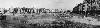
| Arras FeatureType : null Elevation : 78 Lat/Lng : 50.2897 / 2.7808 | Arras is the capital (chef-lieu/préfecture) of the Pas-de-Calais department, which forms part of the region of Hauts-de-France; prior to the reorganization of 2014 it was located in Nord-Pas-de-Calais. The historic centre of the Artois region, with a Baroque town square, Arras is located in Northern (...) |
| 11 | 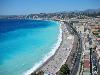
| Nice FeatureType : null Elevation : 22 Lat/Lng : 43.7034 / 7.2663 | Nice (; Niçard , classical norm, or ', nonstandard, ; ; ;) is the fifth most populous city in France and the capital of the Alpes-Maritimes département. The metropolitan area of Nice extends beyond the administrative city limits, with a population of about 1 million, April 2016 – INSEE, 2008 on an (...) |
| 12 | 
| Placentia, Newfoundland and Labrador FeatureType : city Elevation : 4 Lat/Lng : 47.2379 / -53.9723 | Placentia is a town located in the province of Newfoundland and Labrador Canada, It consists of the "Argentia Industrial Park" and amalgamated communities of Townside, Freshwater, Dunville, and Jerseyside. (...) |
| 13 | 
| Sackville, New Brunswick FeatureType : city Elevation : 13 Lat/Lng : 45.9188 / -64.3845 | Sackville is a town in southeastern New Brunswick, Canada. It is home to Mount Allison University, a primarily undergraduate liberal arts university. Historically home to two foundries manufacturing stoves and furnaces, the economy is now driven by the university and tourism (...) |
| 14 | 
| Brussels FeatureType : null Elevation : 66 Lat/Lng : 50.8432 / 4.363 | Brussels , officially the Brussels-Capital Region (All text and all but one graphic show the English name as Brussels-Capital Region.) , is a region of Belgium comprising 19 municipalities, including the City of Brussels, which is the capital of Belgium (...) |
| 15 | 
| University of Paris FeatureType : edu Elevation : 61 Lat/Lng : 48.8486 / 2.3433 | The University of Paris , metonymically known as the Sorbonne , was a university in Paris, France, active 1150–1793, and 1806–1970. Emerging around 1150 as a corporation associated with the cathedral school of Notre Dame de Paris, it was considered the second-oldest university in Europe.Haskins, C (...) |
| 16 | 
| Channel-Port aux Basques FeatureType : null Elevation : 2 Lat/Lng : 47.5691 / -59.1394 | Channel-Port aux Basques is a town at the extreme southwestern tip of Newfoundland fronting on the western end of the Cabot Strait. A Marine Atlantic ferry terminal is located in the town which is the primary entry point onto the island of Newfoundland and the western terminus of the Trans-Canada (...) |
| 17 | 
| Grand Manan FeatureType : isle Elevation : 96 Lat/Lng : 44.6979 / -66.8223 | Grand Manan Island (also simply Grand Manan) is a Canadian island, and the largest of the Fundy Islands in the Bay of Fundy. It is the primary island in the Grand Manan Archipelago, sitting at the boundary between the Bay of Fundy and the Gulf of Maine on the Atlantic coast (...) |
| 18 | 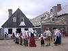
| Fortress of Louisbourg FeatureType : city Elevation : 6 Lat/Lng : 45.8924 / -59.9854 | The Fortress of Louisbourg is a National Historic Site of Canada and the location of a one-quarter partial reconstruction of an 18th-century French fortress at Louisbourg on Cape Breton Island, Nova Scotia. Its two sieges, especially that of 1758, were turning points in the Anglo-French struggle for (...) |
| 19 | 
| Wolfville FeatureType : city Elevation : 75 Lat/Lng : 45.0842 / -64.3517 | Wolfville is a Canadian town in the Annapolis Valley, Kings County, Nova Scotia, located about northwest of the provincial capital, Halifax. The town is home to Acadia University and Landmark East School. The town is a popular tourist destination because of the scenery of the nearby Bay of Fundy and (...) |
| 20 | 
| York Factory FeatureType : landmark Elevation : 9 Lat/Lng : 57.0027 / -92.3048 | York Factory was a settlement and Hudson's Bay Company (HBC) factory (trading post) located on the southwestern shore of Hudson Bay in northeastern Manitoba, Canada, at the mouth of the Hayes River, approximately south-southeast of Churchill (...) |
| 21 | 
| Campobello Island FeatureType : isle Elevation : 35 Lat/Lng : 44.8979 / -66.9251 | Campobello Island is an island located at the entrance to Passamaquoddy Bay, adjacent to the entrance to Cobscook Bay, and within the Bay of Fundy. The island is one of the Fundy Islands and is part of Charlotte County, New Brunswick, Canada.; Statistics Canada (...) |
| 22 | Placentia Bay FeatureType : null Lat/Lng : 47.2508 / -54.2589 | Placentia Bay is a body of water on the southeast coast of Newfoundland, Canada. It is formed by Burin Peninsula on the west and Avalon Peninsula on the east. Fishing grounds in the bay were used by native people long before the first European fishermen arrived in the 16th century (...) | |
| 23 | 
| Fogo Island (Newfoundland and Labrador) FeatureType : isle Elevation : 24 Lat/Lng : 49.6636 / -54.1703 | Fogo Island is the largest of the offshore islands of Newfoundland and Labrador, Canada. It lies off the northeast coast of Newfoundland, northwest of Musgrave Harbour across Hamilton Sound, just east of the Change Islands. The island is about 25 km long and 14 km wide. The total area is (...) |
| 24 | New Brunswick FeatureType : adm1st Elevation : 12 Lat/Lng : 45.9576 / -66.6444 | New Brunswick (; Canadian French pronunciation:) is one of four Atlantic provinces on the east coast of Canada. The indigenous inhabitants of the land at the time of European colonization were the Mi'kmaq, the Maliseet, and the Passamaquoddy peoples, aligned politically within the Wabanaki (...) | |
| 25 | Acadia FeatureType : city Elevation : 81 Lat/Lng : 47.6653 / -65.7542 | Acadia was a colony of New France in northeastern North America that included parts of eastern Quebec, the Maritime provinces, and modern-day Maine to the Kennebec River. During much of the 17th and early 18th centuries, Norridgewock on the Kennebec River and Castine at the end of the Penobscot (...) | |
| 26 | Nova Scotia FeatureType : adm1st Elevation : 228 Lat/Lng : 45.2167 / -62.7 | Nova Scotia (; Latin for "New Scotland"; ; Scottish Gaelic: Alba Nuadh) is one of Canada's three Maritime Provinces, and one of the four provinces that form Atlantic Canada. Its provincial capital is Halifax. Nova Scotia is the second-smallest of Canada's ten provinces, with an area of 55,284 square (...) | |
| 27 | South African Republic FeatureType : adm1st Elevation : 1287 Lat/Lng : -25.7167 / 28.2333 | The South African Republic , often referred to as the Transvaal or as the Transvaal Republic, was an independent and internationally recognised country in Southern Africa from 1852 to 1902. The country defeated the British in what is often referred to as the First Boer War and remained independent (...) | |
| 28 | Saint-Ludger, Quebec FeatureType : null Elevation : 385 Lat/Lng : 45.7209 / -70.6743 | Saint-Ludger is a municipality in the Le Granit Regional County Municipality in Beauce, Quebec, Canada, on the Canada–United States border. Population is 1,197 as of 2006. The municipality of Saint-Ludger was created in 1998 from the amalgamation of the village of Saint-Ludger, the municipality of (...) | |
| 29 | Bathurst, New Brunswick FeatureType : city Elevation : 7 Lat/Lng : 47.6175 / -65.6491 | Bathurst (2011 population; UA 12,275; CA population 13,424) is the county seat for Gloucester County, New Brunswick, and is at the estuary of the Nepisiguit River. (...) | |
| 30 | University of Wollongong FeatureType : edu Elevation : 30 Lat/Lng : -34.4062 / 150.8795 | The University of Wollongong (abbreviated as UOW) is an Australian public research university located in the coastal city of Wollongong, New South Wales, approximately 80 kilometres south of Sydney. As of 2017 the university has an enrolment of more than 32,000 students (including over 12,800 (...) | |
| 31 | Canal FeatureType : null Elevation : 11 Lat/Lng : 51.1384 / -2.7358 | Canals, or navigations, are human-made channels, or artificial waterways, for water conveyance, or to service water transport vehicles. In most cases, the engineered works will have a series of dams and locks that create reservoirs of low speed current flow (...) | |
| 32 | Queen's University Belfast FeatureType : landmark Elevation : 16 Lat/Lng : 54.5844 / -5.9344 | Queen's University Belfast (informally Queen's or QUB) is a public research university in Belfast, Northern Ireland. The university's official title, per its charter, is The Queen's University of Belfast. The university was chartered in 1845, and opened in 1849 as "Queen's College, Belfast" (...) | |
| 33 | Kingdom of Great Britain FeatureType : null Elevation : 10 Lat/Lng : 51.5 / -0.1167 | The Kingdom of Great Britain, officially called simply Great Britain,Parliament of the Kingdom of England. ', Article I, from legislation.gov.uk. "That the two Kingdoms of England and Scotland shall upon the First day of May which shall be in the year One thousand seven hundred and seven and for (...) | |
| 34 | Nordhorn FeatureType : null Elevation : 24 Lat/Lng : 52.4319 / 7.0678 | Nordhorn is the district seat of Grafschaft Bentheim in Lower Saxony's southwesternmost corner near the border with the Netherlands and the boundary with North Rhine-Westphalia. (...) | |
| 35 | Ancien Régime FeatureType : null Elevation : 41 Lat/Lng : 48.8167 / 2.4833 | The Ancien Régime (; ; French for "old regime") was the political and social system of the Kingdom of France from the Late Middle Ages (circa 15th century) until 1789, when hereditary monarchy and the feudal system of French nobility were abolished by the (...) | |
| 36 | University of St Andrews FeatureType : landmark Elevation : 24 Lat/Lng : 56.3412 / -2.793 | The University of St Andrews (; abbreviated as St And, from the Latin Sancti Andreae, in post-nominals) is a British public university in St Andrews, Fife, Scotland. It is the oldest of the four ancient universities of Scotland and the third oldest university in the English-speaking world (following (...) | |
| 37 | University of Greifswald FeatureType : edu Elevation : 10 Lat/Lng : 54.0944 / 13.3744 | The University of Greifswald is a public research university located in Greifswald, Germany, in the state of Mecklenburg-Vorpommern. Founded in 1456 (teaching existed since 1436), it is one of the oldest universities in Europe, with generations of notable alumni and staff having studied or worked in (...) | |
| 38 | Luxembourg FeatureType : country Elevation : 296 Lat/Lng : 49.8144 / 6.1317 | Luxembourg , officially the Grand Duchy of Luxembourg, is a small landlocked country in western Europe. It is bordered by Belgium to the west and north, Germany to the east, and France to the south. Its capital, Luxembourg City, together with Brussels and Strasbourg, is one of the three official (...) | |
| 39 | Catalonia FeatureType : adm1st Elevation : 680 Lat/Lng : 41.8167 / 1.4667 | Catalonia is an autonomous community in Spain on the northeastern corner of the Iberian Peninsula, designated as a nationality by its Statute of Autonomy. Catalonia consists of four provinces: Barcelona, Girona, Lleida, and Tarragona (...) | |
| 40 | Bonavista, Newfoundland and Labrador FeatureType : null Elevation : 4 Lat/Lng : 48.6515 / -53.1129 | Bonavista (2016 population: 3,448) is a town on the Bonavista Peninsula, Newfoundland in the Canadian province of Newfoundland and Labrador. Unlike many Newfoundland coastal settlements, Bonavista was built on an open plain, not in a steep cove, and thus had room to expand to its current area of 31 (...) | |
| 41 | Caraquet FeatureType : city Elevation : 21 Lat/Lng : 47.7656 / -64.9497 | Caraquet is a town in Gloucester County, New Brunswick, Canada. Situated on the shore of Chaleur Bay in the Acadian Peninsula, its name is derived from the Mi'kmaq term for meeting of two rivers. The Caraquet River and Rivière du Nord flow into the Caraquet Bay west of the town. (...) | |
| 42 | 49th parallel north FeatureType : landmark Elevation : 60 Lat/Lng : 49.0 / 0.0 | The 49th parallel north is a circle of latitude that is 49° north of Earth's equator. It crosses Europe, Asia, the Pacific Ocean, North America, and the Atlantic Ocean. The city of Paris is about south of the 49th parallel and is the largest city between the 48th and 49th parallels (...) | |
| 43 | St. Peter's, Nova Scotia FeatureType : city Elevation : 33 Lat/Lng : 45.664 / -60.8945 | St. Peter's (Scottish Gaelic: Baile Pheadair; formerly known as "Santo Pedro", "Saint-Pierre", "Port Toulouse", and "St. Peters") is a small incorporated village located on Cape Breton Island in Richmond County, Nova Scotia, Canada (...) | |
| 44 | Annapolis Royal FeatureType : city Elevation : 13 Lat/Lng : 44.7419 / -65.5156 | Annapolis Royal, formerly known as Port Royal, is a town located in the western part of Annapolis County, Nova Scotia, Canada. Today's Annapolis Royal evolved from the 1605 French settlement of Port Royal (briefly Charlesfort), renamed in honour of Queen Anne following the Siege of Port Royal in (...) | |
| 45 | Cape Breton Regional Municipality FeatureType : null Elevation : 114 Lat/Lng : 46.0021 / -60.2574 | Cape Breton Regional Municipality, often referred to as simply CBRM, is the Canadian province of Nova Scotia's second largest municipality and the economic heart of Cape Breton Island.http://sydneyareachamber.ca/our-community/ As of 2016 the municipality has a population of 94,285 (...) | |
| 46 | University of Victoria FeatureType : edu Elevation : 64 Lat/Lng : 48.465 / -123.3115 | The University of Victoria (UVic) is a major research university located in Victoria, British Columbia, Canada. The University of Victoria, founded in 1963, is the oldest post-secondary institution in British Columbia and began as Victoria College in 1903, as an affiliated branch of McGill (...) | |
| 47 | Mensa International FeatureType : null Elevation : 76 Lat/Lng : 53.0272 / -0.6025 | Mensa is the largest and oldest high IQ society in the world. It is a non-profit organization open to people who score at the 98th percentile or higher on a standardized, supervised IQ or other approved intelligence test (...) | |
| 48 | Atholville, New Brunswick FeatureType : city Elevation : 16 Lat/Lng : 47.9937 / -66.7135 | Atholville (2011 population: 1,237) is a village in Restigouche County, New Brunswick, Canada. The first inhabitants of the area were the Mi'kmaq who settled there in the 6th century BC and were then called Tjikog (...) | |
| 49 | Memramcook, New Brunswick FeatureType : city Elevation : 23 Lat/Lng : 46.0041 / -64.5515 | Memramcook, sometimes also spelt Memramcouke or Memramkouke, is a village in Westmorland County, New Brunswick, Canada. Located in south-eastern New Brunswick, the community is predominantly people of Acadian descent who speak the Chiac derivative of the French language (...) | |
| 50 | Achterveld FeatureType : city Elevation : 8 Lat/Lng : 52.1361 / 5.4969 | Achterveld is a village in the central Netherlands. It is a part of the municipality of Leusden, Utrecht and is located about 8 km east of Amersfoort. The village is a Catholic enclave in a Protestant region. It has a neo-romantic church. In 2001, the village of Achterveld had 1616 inhabitants (...) | |
| 51 | Trepassey FeatureType : city Elevation : 19 Lat/Lng : 46.7332 / -53.3648 | Trepassey , is a small fishing community located in Trepassey Bay on the south eastern corner of the Avalon Peninsula of Newfoundland and Labrador. It was in Trepassey Harbour where the flight of the Friendship took off, with Amelia Earhart on board, the first woman to fly across the Atlantic Ocean (...) | |
| 52 | Fokker F27 Friendship FeatureType : null Elevation : 2471 Lat/Lng : -32.1123 / -64.948 | The Fokker F27 Friendship is a turboprop airliner developed and manufactured by the Dutch aircraft manufacturer Fokker. It has the distinction of being the most numerous post-war aircraft to have been manufactured in the Netherlands; the F27 was also one of the most successful European airliners of (...) | |
| 53 | Petitcodiac River FeatureType : river Lat/Lng : 45.8584 / -64.5668 | The Petitcodiac River , known informally as the Chocolate River, is a river in south-eastern New Brunswick, Canada. The river has a meander length of and is located in Westmorland, Albert, and Kings counties, draining a watershed area of about (...) | |
| 54 | Equinor FeatureType : landmark Elevation : 17 Lat/Lng : 58.8918 / 5.7175 | Equinor ASA (formerly Statoil and StatoilHydro) is a Norwegian multinational energy company headquartered in Stavanger, Norway. It is a petroleum and wind energy company with operations in thirty-six countries. By revenue, while under Statoil name, Equinor was ranked by Forbes Magazine (2013) as the (...) | |
| 55 | Enclave and exclave FeatureType : null Elevation : 28 Lat/Lng : 45.0134 / -73.1933 | An enclave is a territory, or a part of a territory, that is entirely surrounded by the territory of one other state. Territorial waters have the same sovereign attributes as land, and enclaves may therefore exist within territorial waters (...) | |
| 56 | University of New Hampshire FeatureType : edu Elevation : 32 Lat/Lng : 43.1356 / -70.9333 | The University of New Hampshire (UNH) is a public research university in the University System of New Hampshire, in the United States. The university's Durham campus, comprising six colleges, is located in the Seacoast region of the state (...) | |
| 57 | Charlie Hebdo shooting FeatureType : landmark Elevation : 39 Lat/Lng : 48.8592 / 2.3703 | On 7 January 2015 at about 11:30 local time, two brothers, Saïd and Chérif Kouachi, forced their way into the offices of the French satirical weekly newspaper Charlie Hebdo in Paris. Armed with rifles and other weapons, they killed 12 people and injured 11 others (...) | |
| 58 | Pierre Gaultier de Varennes, sieur de La Vérendrye FeatureType : null Elevation : 329 Lat/Lng : 49.3619 / -94.7809 | Pierre Gaultier de Varennes, sieur de La Vérendrye (November 17, 1685 – December 5, 1749) was a French Canadian military officer, fur trader and explorer. In the 1730s, he and his four sons explored the area west of Lake Superior and established trading posts there (...) | |
| 59 | Port au Choix FeatureType : null Elevation : 26 Lat/Lng : 50.705 / -57.327 | Port au Choix or Port aux Choix is a town in the Canadian province of Newfoundland and Labrador. (...) | |
| 60 | Siege of Port Royal (1710) FeatureType : city Elevation : 13 Lat/Lng : 44.7417 / -65.5153 | The Siege of Port Royal (5 – 13 October 1710),Dates in this article are given in the New Style; many older English accounts use Old Style dates for this action: 24 September to 2 October also known as the Conquest of Acadia,Reid, John; Basque, Maurice; Mancke, Elizabeth; Moody, Barry; Plank, (...) | |
| 61 | Norridgewock FeatureType : landmark Elevation : 51 Lat/Lng : 44.767 / -69.8833 | Norridgewock was the name of both an Indian village and a band of the Abenaki ("People of the Dawn") Native Americans/First Nations, an Eastern Algonquian tribe of the United States and Canada. The French of New France called the village Kennebec. The tribe occupied an area in the interior of Maine (...) | |
| 62 | Isthmus of Chignecto FeatureType : null Elevation : 11 Lat/Lng : 45.9164 / -64.1422 | The Isthmus of Chignecto is an isthmus bordering the Maritime provinces of New Brunswick and Nova Scotia that connects the Nova Scotia peninsula with North America. The isthmus separates the waters of Chignecto Bay, a sub-basin of the Bay of Fundy, from those of Baie Verte, a sub-basin of the (...) | |
| 63 | Keolis FeatureType : landmark Elevation : 49 Lat/Lng : 48.8708 / 2.328 | Keolis is a Franco-Québécois private operator of public transport. The company manages bus, metro, tramways and coach networks, rental bikes, car parks, boat shuttles, cable cars, trolleybuses and airport services (...) | |
| 64 | Beaubassin FeatureType : null Elevation : 15 Lat/Lng : 45.8491 / -64.2609 | Beaubassin was an important Acadian village and trading centre on the Isthmus of Chignecto in what is now Nova Scotia, Canada. The area was a significant place in the geopolitical struggle between the British and French empires (...) | |
| 65 | Fort Beauséjour FeatureType : city Elevation : 34 Lat/Lng : 45.8646 / -64.2916 | Fort Beauséjour is a large five-bastioned star fort on the Isthmus of Chignecto, a neck of land connecting present-day New Brunswick with Nova Scotia, Canada. The site was strategically important in Acadia, a French colony that included parts of what is now Quebec, The Maritimes, and northern Maine (...) | |
| 66 | Nova Scotia peninsula FeatureType : landmark Elevation : 106 Lat/Lng : 45.0 / -62.6 | The Nova Scotia peninsula is a peninsula on the Atlantic coast of North America. (...) | |
| 67 | El Al Flight 1862 FeatureType : landmark Elevation : 0 Lat/Lng : 52.3189 / 4.975 | On 4 October 1992, El Al Flight 1862, a Boeing 747 cargo aircraft of the state-owned Israeli airline El Al, crashed into the Groeneveen and Klein-Kruitberg flats in the Bijlmermeer (colloquially "Bijlmer") neighbourhood (part of Amsterdam-Zuidoost) of Amsterdam, the Netherlands (...) | |
| 68 | Villanova College (Australia) FeatureType : null Elevation : 24 Lat/Lng : -27.4958 / 153.0514 | Villanova College is a private, Roman Catholic school for boys located in Coorparoo, a southern suburb of Brisbane, Queensland, Australia. The school has a non-selective enrolment policy for all years and caters for approximately 1,150 boys in three schools, Junior, Middle and Senior from year five (...) | |
| 69 | New Brunswick Theological Seminary FeatureType : landmark Elevation : 24 Lat/Lng : 40.5019 / -74.4481 | New Brunswick Theological Seminary, which has its main campus in New Brunswick, New Jersey, was founded in 1784 and is the oldest independent Protestant seminary extant in the United States. It is one of two operated by the Reformed Church in America (RCA), a mainline Reformed Protestant (...) | |
| 70 | Lawn, Newfoundland and Labrador FeatureType : city Elevation : 39 Lat/Lng : 46.9499 / -55.5316 | Lawn, population approximately 670 , is located at the tip of the Burin Peninsula on Newfoundland's South coast, Newfoundland and Labrador. Lawn is spread around a small harbour in a relatively lush valley. According to one local tradition it was this lushness that inspired Captain James Cook to (...) | |
| 71 | National Museum of Serbia FeatureType : landmark Elevation : 127 Lat/Lng : 44.8167 / 20.4594 | The National Museum of Serbia is the largest and oldest museum in Serbia and former Yugoslavia. It is located in the central zone of Belgrade on a square plot between the Republic Square, formerly Theatre Square, and three streets: Čika Ljubina, Vasina and Laze Pačua (...) | |
| 72 | Grand Bank FeatureType : null Elevation : 5 Lat/Lng : 47.1 / -55.765 | Grand Bank, Newfoundland and Labrador, Canada or 'Grand Banc' as the first French settlers pronounced it, is a small rural town with a population of 2,580. It is located on the southern tip or "toe" of the Burin Peninsula (also known as "the boot"), 360 km from the province's capital of St. John's (...) | |
| 73 | Woody Point, Newfoundland and Labrador FeatureType : city Elevation : 258 Lat/Lng : 49.5 / -57.9316 | Woody Point is a town located in the heart of Gros Morne National Park, on the western coast of Newfoundland. Situated on Bonne Bay, the Town of Woody Point encompasses three areas: Curzon Village, Woody Point and Winterhouse Brook. It has a total population of 281 residents (...) | |
| 74 | Pingo FeatureType : landmark Lat/Lng : 69.3997 / -133.0797 | A pingo, also called a hydrolaccolith or a bulgunniakh, is a mound of earth-covered ice found in the Arctic and subarctic that can reach up to in height and up to in diameter. The term originated as the Inuvialuktun word for a small hill. The plural form is "pingos" (...) | |
| 75 | St. John's Cathedral (Toronto) FeatureType : null Elevation : 99 Lat/Lng : 43.6397 / -79.4326 | St. John's Cathedral Polish Catholic Church in the Parkdale area of Toronto, Ontario, is the seat of the Polish National Catholic Church's (PNCC) diocese in Canada. (...) | |
| 76 | Fort Albany First Nation FeatureType : null Elevation : 1 Lat/Lng : 52.2511 / -81.5011 | Fort Albany First Nation is a Cree First Nation reserve in Cochrane District in Northeastern Ontario, Canada. Situated on the southern shore of the Albany River, Fort Albany First Nation is only accessible by air or by winter road (...) | |
| 77 | Argentia FeatureType : null Elevation : 16 Lat/Lng : 47.3031 / -53.9886 | Argentia is a Canadian commercial seaport and industrial Park located in the Town of Placentia, Newfoundland and Labrador. It is situated on the southwest coast of the Avalon Peninsula and defined by a triangular shaped headland which reaches northward out into Placentia Bay creating a natural (...) | |
| 78 | Belleoram FeatureType : null Elevation : 205 Lat/Lng : 47.5166 / -55.415 | Belleoram is a village on the shores of Fortune Bay in the Canadian province of Newfoundland and Labrador. The community sits on a narrow strip of land hemmed in between the bay and steep hills that rise behind it (...) | |
| 79 | Tivoli FeatureType : null Elevation : 249 Lat/Lng : 41.9609 / 12.7989 | Tivoli may refer to: (...) | |
| 80 | Vinegar Hill, Brooklyn FeatureType : city Elevation : 13 Lat/Lng : 40.7026 / -73.9811 | Vinegar Hill is a neighborhood in the borough of Brooklyn in New York City on the East River Waterfront between Dumbo and the Brooklyn Navy Yard. The neighborhood is locally governed by Brooklyn Community Board 2 and is policed by the New York City Police Department's 84th Precinct (...) | |
| 81 | Aulac, New Brunswick FeatureType : city Elevation : 23 Lat/Lng : 45.8685 / -64.2824 | Aulac is a Canadian community in Westmorland County, New Brunswick. It is located near the larger town of Sackville by the provincial border with Nova Scotia. (...) | |
| 82 | Fort Anne FeatureType : null Elevation : 10 Lat/Lng : 44.7411 / -65.5189 | Fort Anne is a four-star fort built to protect the harbour of Annapolis Royal, Nova Scotia. The fort repelled all French attacks during the early stages of King George's War. Now designated a National Historic Site of Canada, it is managed by Parks Canada (...) | |
| 83 | Green Island (Fortune), Newfoundland and Labrador FeatureType : null Elevation : 15 Lat/Lng : 46.8788 / -56.0891 | Green Island (in) is a rocky island in the mouth of Fortune Bay, Newfoundland. It is located about west of the Burin Peninsula of Newfoundland and east of Langlade Island in Saint-Pierre and Miquelon. In Article XIII of the Treaty of Utrecht (1713), France acknowledged British ownership of (...) | |
| 84 | Battle of Norridgewock FeatureType : null Elevation : 51 Lat/Lng : 44.767 / -69.8833 | The Norridgewock Raid occurred in contested lands being fought over by England, France and the Wabanaki Confederacy, during the colonial frontier conflict referred to as Governor Dummer's War. Despite being called a 'battle' by some, the raid was essentially a massacre of Indians by colonial British (...) | |
| 85 | Château de Ranton FeatureType : landmark Elevation : 109 Lat/Lng : 47.0006 / -0.0292 | The Château de Ranton is a small fortified castle in the village of Ranton, in the Department of the Vienne just west of Loudun, and south of the Loire. It was one of the front-line of fortresses which were built to defend the royal city of Loundun at the beginning of the Hundred Years' War in (...) | |
| 86 | Acadia River FeatureType : landmark Elevation : 4 Lat/Lng : 45.4837 / -73.2684 | The Acadia River flows Northerly over 82 km through seven municipalities in the MRC La Vallée-du-Richelieu, Les Jardins-de-Napierville and Le Haut-Richelieu, in Montérégie, on the South Shore of St. Lawrence river, the Quebec, Canada (...) | |
| 87 | Battle of Pequawket FeatureType : event Elevation : 118 Lat/Lng : 44.021 / -70.936 | The Battle of Pequawket (also known as Lovewell's Fight) occurred on May 9, 1725 (O.S.),The date of the battle is given variously as Saturday 8 May or Sunday 9 May. Contemporary official accounts used the date 9 May but early newspapers and pamphlets published the date as 8 May (...) | |
| 88 | Battle of Winnepang FeatureType : null Elevation : 11 Lat/Lng : 44.7756 / -63.0553 | The Battle of Winnepang occurred during Dummer's War when New England forces attacked Mi'kmaq at present day Jeddore Harbour, Nova Scotia., names the site of the battle site as "Winnepang". Rev. Silas , states Jeddore was called "Wineboogwechk", which is likely a corruption of Winnepang (...) | |
| 89 | Port au Port Peninsula FeatureType : landmark Elevation : 62 Lat/Lng : 48.5833 / -58.9985 | The Port au Port Peninsula (Mi'kmaq: Kitpu) is a peninsula in the Canadian province of Newfoundland and Labrador. Roughly triangular in shape, it is located on the west coast of the island of Newfoundland. (...) | |
| 90 | Siege of Annapolis Royal (1744) FeatureType : null Elevation : 21 Lat/Lng : 44.7411 / -65.5113 | The Siege of Annapolis Royal (also known as the Siege of Fort Anne) in 1744 involved two of four attempts by the French, along with their Acadian and native allies, to regain the capital of Nova Scotia/Acadia, Annapolis Royal, during King George's War (...) | |
| 91 | Jemseg, New Brunswick FeatureType : null Elevation : 16 Lat/Lng : 45.8299 / -66.1082 | Jemseg is a Canadian rural community in Queens County, New Brunswick. It is located on the east bank of the Jemseg River along its short run from Grand Lake to the Saint John River. The village briefly served as the Capital of Acadia (1690–91).John Reid. 1686-1720: Imperial Intrusions. in Buckner, P (...) | |
| 92 | Battle of Bloody Creek (1711) FeatureType : null Elevation : 75 Lat/Lng : 44.8167 / -65.2833 | The Battle of Bloody Creek was fought on 10/21 June 1711French records, using the modern Gregorian calendar, indicate the date of this action as 21 June; English records, which were still using the Julian calendar, list it as happening on 10 June (...) | |
| 93 | University College Roosevelt FeatureType : null Elevation : 6 Lat/Lng : 51.4993 / 3.6108 | University College Roosevelt (UCR), formerly known as Roosevelt Academy, is a small, selective, honors undergraduate liberal arts and science college located in Middelburg in the Netherlands and the sole university in Zeeland (...) | |
| 94 | Kekionga FeatureType : null Elevation : 231 Lat/Lng : 41.0886 / -85.1239 | Kekionga (meaning “blackberry bush”)According to J. Dunn, Jr., the name "usually said to mean "blackberry patch," or "blackberry bush," this plant being considered an emblem of antiquity because it sprang up on the sites of old villages (...) | |
| 95 | Pacquet FeatureType : city Lat/Lng : 50.0 / -55.867 | Pacquet ("hideaway" in French) is a town in the Canadian province of Newfoundland and Labrador. The town had a population of 164 in 2016, down from 184 in the Canada 2011 Census. Located in White Bay, on the Baie Verte Peninsula in North-Eastern Newfoundland, it was surveyed in 1801 by Capt (...) | |
| 96 | BeNe League (ice hockey) FeatureType : null Elevation : -1 Lat/Lng : 52.3493 / 4.9445 | The BeNe League is the highest-level ice hockey league in Belgium and the Netherlands. The league was founded in 2015, following a merger between the Belgian Hockey League and the Dutch Eredivisie and thus became the top tier of the sport in both nations (...) | |
| 97 | Siege of St. John's FeatureType : event Elevation : 23 Lat/Lng : 47.5708 / -52.6991 | The Siege of St. John's was a failed attempt by French forces led by Daniel d'Auger de Subercase to take the fort at St. John's, Newfoundland during the winter months of 1705, in Queen Anne's War.All dates are given in New Style; in Old Style dates (which might be used in older English and British (...) | |
| 98 | Washington International School FeatureType : null Elevation : 85 Lat/Lng : 38.9338 / -77.0617 | Washington International School (also known as Washington International or simply WIS; ;) is a coeducational private international school for day students in grades preschool through 12. The school has two campuses in Northwest Washington, DC (...) | |
| 99 | Port-Toulouse FeatureType : null Elevation : 15 Lat/Lng : 45.6567 / -60.8669 | Port-Toulouse was an Acadian village situated in the French colony of Île-Royale, which is now Cape Breton Island. It was located on the present site of the Nova Scotian village of St. Peter's, on the strait that separates Bras d'Or Lake from the Atlantic Ocean. (...) | |
| 100 | St. Vincent de Paul Roman Catholic Church (Toronto) FeatureType : null Elevation : 103 Lat/Lng : 43.6471 / -79.449 | St. Vincent de Paul is a Roman Catholic church in Toronto, Ontario, Canada, part of the Roman Catholic Archdiocese of Toronto. It has been served since 1995 by clergy of the Oratory of St. Philip Neri and St. Philip's Seminary who reside at the mother parish of Holy Family Roman Catholic Church, (...) | |
| 101 | Grand Bay (Newfoundland and Labrador) FeatureType : null Elevation : 35 Lat/Lng : 47.6 / -59.1653 | Grand Bay (NST) is a small bay immediately to the west of Channel-Port aux Basques, Newfoundland, Canada. Two communities line the bay, on the east is Grand Bay East and on the west, Grand Bay West. Grand Bay first appeared on Captain James Cook's 1766 chart of the south coast of Newfoundland (...) | |
| 102 | Lahore Ahmadiyya Movement for the Propagation of Islam FeatureType : landmark Elevation : 17 Lat/Lng : 51.4222 / -0.1706 | The Lahore Ahmadiyya Movement for the Propagation of Islam, (; Aḥmadiyyah Anjuman-i Ishāʿat-i Islām, Lāhawr) is a separatist group within the Ahmadiyya movement that formed in 1914 as a result of ideological and administrative differences following the demise of Hakim Nur-ud-Din, the first Caliph (...) | |
| 103 | Fort Saint Jacques FeatureType : landmark Lat/Lng : 51.4889 / -78.7519 | Fort Saint Jacques, Fort Rupert, or Fort Charles was a fur trading post on James Bay at the mouth of the Rupert River. It was located in what is now Waskaganish, Nord-du-Québec region, Quebec, Canada. Fort Charles was founded in 1668 in northern western Quebec on the James Bay, at the mouth of the (...) | |
| 104 | De Bijenkorf FeatureType : landmark Elevation : 13 Lat/Lng : 52.3732 / 4.8939 | De Bijenkorf (literally, "the beehive") is a chain of high-end department stores in the Netherlands, with its flagship store on Dam Square in Amsterdam. The chain is owned by the Weston family, which also owns Britain's Selfridges, Canada's Holt Renfrew and Ireland's Brown Thomas. (...) | |
| 105 | Fort Lawrence, Nova Scotia FeatureType : null Elevation : 15 Lat/Lng : 45.8491 / -64.2609 | Fort Lawrence is a Canadian rural community located on the Isthmus of Chignecto in Cumberland County, Nova Scotia, which is named after Fort Lawrence. Situated 1 km east of the Missaguash River which forms the inter-provincial boundary with New Brunswick, Fort Lawrence is situated on a low ridge (...) | |
| 106 | Freshwater, Placentia Bay, Newfoundland and Labrador FeatureType : null Elevation : 105 Lat/Lng : 47.2591 / -53.9838 | Freshwater is a settlement in Newfoundland and Labrador on Placentia Bay. Placentia was originally settled by the French in the 1630s that fishing settlement was called Petit Plaisance, meaning "Pleasant Little Place" (...) | |
| 107 | SS Soesterberg FeatureType : null Lat/Lng : 57.2 / -10.7167 | SS Soesterberg was a Dutch-owned cargo steamship that was built in Belgium in 1927 and sunk by a U-boat in 1940 in the Battle of the Atlantic. (...) | |
| 108 | Port Morien FeatureType : null Elevation : 12 Lat/Lng : 46.1321 / -59.8751 | Port Morien (also referred to as "Morien") is a small fishing community of 700 people in the Canadian province of Nova Scotia, located in the southeastern Cape Breton Island near the rural community Donkin, and six miles from the town of Glace Bay. (...) | |
| 109 | Oderin Island (Newfoundland and Labrador) FeatureType : null Elevation : 46 Lat/Lng : 47.2901 / -54.809 | Oderin Island is an island in the province of Newfoundland and Labrador in western Placentia Bay, located about 30 km northeast of Marystown. Oderin was originally settled by the French who considered it an important fishing post and had fortified it against the English (...) | |
| 110 | Anzali Lagoon FeatureType : null Elevation : -23 Lat/Lng : 37.4711 / 49.4622 | Anzali Lagoon (also Anzali Mordab, Anzali Bay, Pahlavi Mordab, Pahlavi Bay or Anzali Liman), accessed 29 November 2008 is a coastal liman, or lagoon, in the Caspian Sea near Bandar-e Anzali, in the northern Iranian province of Gilan (...) | |
| 111 | Battle of Fort Albany (1709) FeatureType : null Elevation : 1 Lat/Lng : 52.2511 / -81.5011 | The Battle of Fort Albany (about 26 June 1709) was an attack by French colonial volunteers and their native allies against the Canadian Hudson's Bay Company outpost of Fort Albany in the southern reaches of Hudson Bay (...) | |
| 112 | Siege of Annapolis Royal (1745) FeatureType : null Elevation : 21 Lat/Lng : 44.7411 / -65.5113 | The Siege of Annapolis Royal in 1745 involved the third of four attempts by the French, along with their Acadian and native allies, to regain the capital of Nova Scotia/Acadia, Annapolis Royal, during King George's War (...) | |
| 113 | Battle of St. John's FeatureType : event Elevation : 23 Lat/Lng : 47.5708 / -52.6991 | The Battle of St. John's was the French capture of St. John's, the capital of the British Colony of Newfoundland, on , during Queen Anne's War. A mixed and motley force of 164 men led by Joseph de Monbeton de Brouillan de Saint-Ovide, king's lieutenant to Philippe Pastour de Costebelle, the French (...) | |
| 114 | Fort William, Newfoundland FeatureType : null Elevation : 29 Lat/Lng : 47.5708 / -52.7006 | Fort William was a fort in St. John's built in 1698 to protect English interests in Newfoundland, primarily against French opposition. It was the original headquarters of the British garrison in Newfoundland. A second fort, known as Fort George was situated at the east end of the harbour connected (...) | |
| 115 | Fort Lawrence (Nova Scotia) FeatureType : landmark Elevation : 14 Lat/Lng : 45.8478 / -64.2618 | Fort Lawrence was a British fort built during Father Le Loutre's War and located on the Isthmus of Chignecto (in the modern-day community of Fort Lawrence). (...) | |
| 116 | Holy Family Roman Catholic Church, Parkdale FeatureType : null Elevation : 97 Lat/Lng : 43.6378 / -79.4344 | Holy Family is a Roman Catholic church in Toronto's west end neighbourhood of Parkdale and within the Roman Catholic Archdiocese of Toronto. It has been served since 1979 by clergy of the Oratory of St Philip Neri who also run a seminary from the location. (...) | |
| 117 | St. Esprit, Nova Scotia FeatureType : null Elevation : 12 Lat/Lng : 45.6354 / -60.5434 | St. Esprit is a small community located in Richmond County on the south shore of Cape Breton Island, Nova Scotia. It is situated between Louisbourg, to the east, and St. Peter's, to the west. The community is loosely centered on St. Esprit Lake and is sparsely populated (...) | |
| 118 | Newfoundland expedition (1702) FeatureType : event Lat/Lng : 47.0873 / -54.6698 | The Newfoundland expedition was a naval raiding expedition led by English Captain John Leake between August and October 1702 that targeted French colonial settlements on the North Atlantic island of Newfoundland and its satellite Saint Pierre (...) | |
| 119 | Fort Royal (Newfoundland) FeatureType : null Elevation : 84 Lat/Lng : 47.2511 / -53.9715 | Fort Royal is a French fort built in 1687 on the island of Newfoundland during the time of New France. In 1662, the French established a commercial counter on a well protected hill overlooking Placentia Bay which separates the Avalon Peninsula form the rest of Newfoundland island and situated near (...) | |
 by
by