| 35 records found in wikipedia | |||
| 1 | 
| Palo Alto, California  FeatureType : null Elevation : 8 Lat/Lng : 37.4292 / -122.1381 | Palo Alto is a charter city located in the northwest corner of Santa Clara County, California, United States, in the San Francisco Bay Area. Palo Alto means tall tree in Spanish; the city is named after a coastal redwood tree called El Palo Alto. The city was established by Leland Stanford Sr (...) |
| 2 | 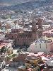
| Zacatecas FeatureType : adm1st Elevation : 2105 Lat/Lng : 23.3 / -102.7 | Zacatecas , officially the Free and Sovereign State of Zacatecas , is one of the 31 states which, with the Federal District, comprise the 32 Federal Entities of Mexico. It is divided into 58 municipalities and its capital city is Zacatecas City. Zacatecas is located in North-Central Mexico (...) |
| 3 | 
| Jalisco FeatureType : adm1st Elevation : 1492 Lat/Lng : 20.5667 / -103.6764 | Jalisco , officially the Free and Sovereign State of Jalisco , is one of the 31 states which, with the Federal District, comprise the 32 Federal Entities of Mexico. It is located in Western Mexico and is bordered by six states which are Nayarit, Zacatecas, Aguascalientes, Guanajuato, Michoacán and (...) |
| 4 | 
| Puerto Rico FeatureType : country Elevation : 500 Lat/Lng : 18.2189 / -66.5733 | Puerto Rico (Spanish for "Rich Port"), officially the Commonwealth of Puerto Rico ("Free Associated State of Puerto Rico") and briefly called Porto Rico, is an unincorporated territory of the United States located in the northeast Caribbean Sea, approximately southeast of Miami, Florida (...) |
| 5 | 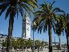
| San Francisco FeatureType : null Elevation : 32 Lat/Lng : 37.7793 / -122.4192 | San Francisco (SF; ; Spanish for 'Saint Francis';), officially the City and County of San Francisco, is the cultural, commercial, and financial center of Northern California. San Francisco is the 13th most populous city in the United States, and the 4th most populous in California, with 884,363 (...) |
| 6 | Los Realejos FeatureType : null Elevation : 297 Lat/Lng : 28.3849 / -16.5827 | Los Realejos is a town and a municipality the northern part of the island of Tenerife, which forms part of the Canary Islands. It is part of the province of Santa Cruz de Tenerife, Spain. The town is located 2 km from the north coast, 5 km southwest of Puerto de la Cruz, 6 km west of La Orotava, and (...) | |
| 7 | 
| SS America (1939) FeatureType : landmark Elevation : 16 Lat/Lng : 28.3461 / -14.1804 | SS America was an ocean liner built in 1940 for the United States Lines and was designed by the noted American naval architect William Francis Gibbs. She carried many names in the 54 years between her construction and her 1994 wrecking, as she served as the SS America (carrying this name three (...) |
| 8 | San Francisco Bay Area FeatureType : null Lat/Lng : 37.75 / -122.2833 | The San Francisco Bay Area (popularly referred to as the Bay Area) is a populous region surrounding the San Francisco, San Pablo and Suisun estuaries in the northern part of the U.S. state of California. Although the exact boundaries of the region vary depending on the source, the Bay Area is (...) | |
| 9 | Santa Clara Valley FeatureType : landmark Elevation : 14 Lat/Lng : 37.3669 / -121.9839 | The Santa Clara Valley runs south-southeast from the southern end of San Francisco Bay in Northern California in the United States. The northern, urbanized end of the valley is part of a region locally known as the "South Bay" and also part of the electronics, research, and technology area known as (...) | |
| 10 | German colonial empire FeatureType : country Elevation : 33 Lat/Lng : 52.5167 / 13.4 | The German colonial empire constituted the overseas colonies, dependencies and territories of Imperial Germany. The chancellor of this time period was Otto von Bismarck. Short-lived attempts of colonization by individual German states had occurred in preceding centuries, but crucial colonial efforts (...) | |
| 11 | Pumped-storage hydroelectricity FeatureType : null Elevation : 646 Lat/Lng : 38.2089 / -79.8 | Pumped-storage hydroelectricity (PSH), or pumped hydroelectric energy storage (PHES), is a type of hydroelectric energy storage used by electric power systems for load balancing. The method stores energy in the form of gravitational potential energy of water, pumped from a lower elevation reservoir (...) | |
| 12 | San Antonio FeatureType : city Elevation : 224 Lat/Lng : 29.4286 / -98.4933 | San Antonio (; from Spanish, "Saint Anthony"), officially the City of San Antonio, is the seventh most populous city in the United States and the second most populous city in both Texas and the Southern United States., Census.gov – "American Factfinder" July 2014 (...) | |
| 13 | Roman Catholic Diocese of San Jose in California FeatureType : null Elevation : 38 Lat/Lng : 37.3019 / -121.8753 | The Roman Catholic Diocese of San José in California is an ecclesiastical territory or diocese of the Roman Catholic Church in the northern California region of the United States. It comprises Santa Clara County, and is led by a bishop. Its patron saints are Saint Joseph and Saint Clare of Assisi (...) | |
| 14 | Campoo FeatureType : adm3rd Elevation : 879 Lat/Lng : 42.9989 / -4.0956 | Campoo (really called Campoo-Los Valles) is a comarca of Cantabria (Spain) located in the High Ebro, with a surface little bigger than 1,000 km2, and including the municipalities of Hermandad de Campoo de Suso, Campoo de Enmedio, Campoo de Yuso, Valdeolea, Valdeprado del Río, Valderredible, Reinosa, (...) | |
| 15 | Texas FeatureType : adm1st Elevation : 504 Lat/Lng : 31.6667 / -99.45 | Texas (; or Tejas) is the second largest state in the United States by both area and population. Geographically located in the South Central region of the country, Texas shares borders with the U.S. states of Louisiana to the east, Arkansas to the northeast, Oklahoma to the north, New Mexico to the (...) | |
| 16 | Google FeatureType : landmark Elevation : 7 Lat/Lng : 37.4222 / -122.0844 | Google LLC is an American multinational technology company that specializes in Internet-related services and products, which include online advertising technologies, search engine, cloud computing, software, and hardware. Google was founded in 1998 by Larry Page and Sergey Brin while they were Ph.D (...) | |
| 17 | Jiquipilco FeatureType : null Elevation : 2552 Lat/Lng : 19.5821 / -99.6469 | Jiquipilco Municipality is one of the municipalities of the State of Mexico in Mexico. It is north of the Toluca Valley, part of the region consisting of the southern and western slopes of Cerro La Catedral, which has a concentration of speakers of the Otomi language (...) | |
| 18 | Sonora FeatureType : adm1st Elevation : 465 Lat/Lng : 29.6461 / -110.8689 | Sonora , officially Estado Libre y Soberano de Sonora , is one of 31 states that, with Mexico City, comprise the 32 federal entities of United Mexican States. It is divided into 72 municipalities; the capital city is Hermosillo (...) | |
| 19 | Global city FeatureType : null Lat/Lng : 40.39 / -73.56 | A global city, also called world city or sometimes alpha city or world center, is a city which is a primary node in the global economic network. The concept comes from geography and urban studies, and the idea that globalization is created, facilitated, and enacted in strategic geographic locales (...) | |
| 20 | Tequixquiac FeatureType : null Elevation : 2219 Lat/Lng : 19.9094 / -99.1447 | Tequixquiac is a municipality located in the Zumpango Region of the State of Mexico in Mexico. The municipality is located north of Mexico City within the valley that connects the Valley of Mexico with the Mezquital Valley. The name comes from Nahuatl and means "place of tequesquite waters" (...) | |
| 21 | Cayey, Puerto Rico FeatureType : null Elevation : 397 Lat/Lng : 18.1119 / -66.1661 | Cayey is a mountain municipality in central Puerto Rico (U.S.) located on the Central Mountain range, north of Salinas and Guayama; south of Cidra and Caguas; east of Aibonito and Salinas; and west of San Lorenzo (...) | |
| 22 | California High-Speed Rail FeatureType : null Elevation : 60 Lat/Lng : 37.0042 / -121.5667 | California High-Speed Rail (abbreviated CAHSR or CHSR) is a high-speed rail system under construction in California in the United States. It is projected to connect the Anaheim Regional Transportation Intermodal Center in Anaheim and Union Station in Downtown Los Angeles with the Salesforce Transit (...) | |
| 23 | Solar power FeatureType : null Elevation : 1292 Lat/Lng : 37.55 / 105.0539 | Solar power is the conversion of energy from sunlight into electricity, either directly using photovoltaics (PV), indirectly using concentrated solar power, or a combination. Concentrated solar power systems use lenses or mirrors and tracking systems to focus a large area of sunlight into a small (...) | |
| 24 | Pau FeatureType : null Elevation : 7 Lat/Lng : 15.0279 / 120.7243 | Pau may refer to: ==Places== * Pau (Aachen), a river in North Rhine-Westphalia, Germany * Pau (river), a river of south-western France (Gave de Pau) * Pau, Edom, a city in the Bible * Pau, Pyrénées-Atlantiques, France, a city ** Arrondissement of Pau, a district containing the French city * Pau, (...) | |
| 25 | Peñamiller FeatureType : null Elevation : 1336 Lat/Lng : 21.0519 / -99.815 | Peñamiller is a town in Peñamiller Municipality in the Mexican state of Querétaro. It is part of the Sierra Gorda region with about eighty percent of the territory belonging to the Sierra Gorda Biosphere of Querétaro (...) | |
| 26 | Memorial Park FeatureType : null Elevation : 885 Lat/Lng : -34.4568 / 149.4762 | Memorial Park may refer to either a public park dedicated in memorial to an event, or a cemetery (modern term for such). (...) | |
| 27 | Beijing Legation Quarter FeatureType : landmark Elevation : 52 Lat/Lng : 39.903 / 116.4016 | The Beijing Legation Quarter was the area in Beijing, China where a number of foreign legations were located between 1861 and 1959. In the Chinese language, the area is known as Dong Jiaomin Xiang , which is the name of the hutong (lane or small street) through the area (...) | |
| 28 | History of radio FeatureType : null Elevation : 179 Lat/Lng : 48.2097 / 16.3831 | The early history of radio is the history of technology that produces and uses radio instruments that use radio waves. Within the timeline of radio, many people contributed theory and inventions in what became radio. by Mary Bellis (ThoughtCo.com) Radio development began as "wireless telegraphy" (...) | |
| 29 | Concrete ship FeatureType : null Lat/Lng : 20.9213 / -156.9101 | Concrete ships are built of steel and ferrocement (reinforced concrete) instead of more traditional materials, such as steel or wood. The advantage of ferrocement construction is that materials are cheap and readily available, while the disadvantages are that construction labor costs are high, as (...) | |
| 30 | Tamalpais High School FeatureType : edu Elevation : 14 Lat/Lng : 37.8921 / -122.5308 | Tamalpais High School (often abbreviated as Tam) is a public secondary school located in Mill Valley, California in the San Francisco Bay Area. It is named after nearby Mount Tamalpais, which rises more than above Mill Valley (...) | |
| 31 | David Grant USAF Medical Center FeatureType : landmark Elevation : 30 Lat/Lng : 38.2697 / -121.9638 | The David Grant USAF Medical Center (DGMC) at Travis Air Force Base in Fairfield, California, is the U.S. Air Force’s largest medical center in the continental United States and serves military beneficiaries throughout eight western states (...) | |
| 32 | Bodeguita del medio FeatureType : landmark Elevation : 10 Lat/Lng : 23.1408 / -82.3522 | La Bodeguita del Medio is a typical restaurant-bar of Havana (Cuba). It is a famous tourist destination because of the personalities which have patronized it: Salvador Allende, the poet Pablo Neruda, the artist Josignacio and many others (...) | |
| 33 | Seacliff State Beach FeatureType : null Elevation : 13 Lat/Lng : 36.9722 / -121.9139 | Seacliff State Beach is a state beach park on Monterey Bay, in the town of Aptos, Santa Cruz County, California. It is located off Highway 1 on State Park Drive, about 5 miles (8 km) south of Santa Cruz, . The beach is most known for the concrete ship SS Palo Alto lying in the water (...) | |
| 34 | Menlo College FeatureType : edu Elevation : 22 Lat/Lng : 37.455 / -122.193 | Menlo College is a private, four-year baccalaureate college specializing in business located in the Silicon Valley town of Atherton, California, United States. (...) | |
| 35 | Allied Arts Guild FeatureType : null Elevation : 26 Lat/Lng : 37.4415 / -122.179 | Allied Arts Guild is a complex of artist studios, shops, restaurant, and gardens in Menlo Park, California. It is used as a venue for both public and private events. (...) | |
 by
by