| 46 records found in wikipedia | |||
| 1 | 
| Matadi  FeatureType : null Elevation : 133 Lat/Lng : -5.8174 / 13.4708 | Matadi is the chief sea port of the Democratic Republic of the Congo and the capital of the Kongo Central province. It has a population of 245,862 (2004). Matadi is situated on the left bank of the Congo River, from the mouth and below the last navigable point before the rapids that make the river (...) |
| 2 | 
| Democratic Republic of the Congo FeatureType : country Elevation : 444 Lat/Lng : -2.3333 / 22.8 | The Democratic Republic of the Congo , also known as DR Congo, the DRC, Congo-Kinshasa, East Congo, or simply the Congo, is the southernmost country located in East Africa and Central Africa. It is sometimes referred to by its former name of Zaire, which was its official name between 1971 and 1997 (...) |
| 3 | 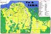
| Kinshasa FeatureType : null Elevation : 283 Lat/Lng : -4.3317 / 15.3139 | Kinshasa (; ; formerly Léopoldville (or Dutch nocat=true)) is the capital and the largest city of the Democratic Republic of the Congo. The city is situated alongside the Congo River. Once a site of fishing and trading villages, Kinshasa is now a megacity with an estimated population of more than (...) |
| 4 | Kongo Central FeatureType : adm1st Elevation : 146 Lat/Lng : -5.8167 / 13.4833 | Kongo Central, formerly Bas-Congo, is one of the 26 provinces of the Democratic Republic of the Congo. Its capital is Matadi. (...) | |
| 5 | Congo River FeatureType : landmark Lat/Lng : -6.0792 / 12.45 | The great Congo River (also spelled Kongo River and known as the Zaire River; ; ;) is the second longest river in Africa, shorter only than the Nile, as well as the second largest river in the world by discharge volume, following only the Amazon (...) | |
| 6 | Boma, Democratic Republic of the Congo FeatureType : null Elevation : 13 Lat/Lng : -5.8487 / 13.0561 | Boma is a port town on the Congo River, some 100 km upstream from the Atlantic Ocean, in the Kongo Central province of the Democratic Republic of the Congo. It had an estimated population of 162,521 in 2012. Boma was the capital city of the Congo Free State and Belgian Congo (the modern Democratic (...) | |
| 7 | Belgian Congo FeatureType : city Elevation : 279 Lat/Lng : -4.3167 / 15.3167 | The Belgian Congo was a Belgian colony in Central Africa from 1908 until independence in 1960. The former colony is now the Democratic Republic of the Congo (DRC). Colonial rule in the Congo began in the late 19th century (...) | |
| 8 | Kimpese FeatureType : null Elevation : 331 Lat/Lng : -5.5627 / 14.4461 | Kimpese is a town in the Cataractes District of Bas-Congo province, Democratic Republic of the Congo. It lies on the main road and railway between Kinshasa and the provincial capital Matadi, at an altitude of 990 ft (301 m) above sea level (...) | |
| 9 | M'pozo River FeatureType : null Elevation : 14 Lat/Lng : -5.8107 / 13.4824 | The M'pozo is a river in the province of Bas-Congo in the Democratic Republic of the Congo. Its source is located in Angola. The river ends on the left bank of the Congo River, a few kilometres upstream of Matadi (...) | |
| 10 | 
| Shinkolobwe FeatureType : null Elevation : 1410 Lat/Lng : -11.055 / 26.5473 | Shinkolobwe, or Kasolo, or Chinkolobew, or Shainkolobwe, is a radium and uranium mine in the Katanga province of the Democratic Republic of the Congo (DRC), located 20 km west of Likasi, 20 km south of Kambove, and about 145 km northwest of Lubumbashi (...) |
| 11 | Matadi (commune) FeatureType : city Elevation : 183 Lat/Lng : -5.8386 / 13.4631 | Matadi is a commune of the city of Matadi in the Democratic Republic of the Congo. | |
| 12 | Moanda, Democratic Republic of the Congo FeatureType : city Elevation : 26 Lat/Lng : -5.9342 / 12.3494 | Moanda or Muanda is a town and territory lying on the Atlantic Ocean coast of the Democratic Republic of Congo at the mouth of the Congo River., United States National Geospatial-Intelligence Agency It is situated in Kongo Central Province, and has a population of 50,000 (...) | |
| 13 | Livingstone Falls FeatureType : waterbody Elevation : 263 Lat/Lng : -4.3219 / 15.2078 | Livingstone Falls (French, Chutes Livingstone) — named for the explorer David Livingstone — are a succession of enormous rapids on the lower course of the Congo River in west equatorial Africa, downstream from Malebo Pool in the Democratic Republic of the Congo.Stanley, H.M (...) | |
| 14 | Matadi Tshimpi Airport FeatureType : null Elevation : 340 Lat/Lng : -5.8 / 13.4403 | Matadi Tshimpi Airport is an airport serving the city of Matadi in Kongo Central Province, Democratic Republic of the Congo. The runway is north of Matadi, across the Congo River. The Matadi NDB (Ident: MS) is southeast of the runway. (...) | |
| 15 | Noqui FeatureType : null Elevation : 47 Lat/Lng : -5.8681 / 13.4325 | Noqui (or Noki) is a town and municipality in Zaire Province in Angola. It is on the Congo River, just across the border from the city of Matadi in the Democratic Republic of the Congo. Noki was the site of an early European trading post (...) | |
| 16 | Vivi, Democratic Republic of the Congo FeatureType : city Elevation : 138 Lat/Lng : -5.7936 / 13.4812 | Vivi is a town in the Bas-Congo province of the Democratic Republic of the Congo. It is located on the Congo River, near the provincial capital of Matadi. In the 19th century, it served as the first capital of the Congo Free State from July, 1885 to May 1, 1886, when the capital was relocated to (...) | |
| 17 | Inland port FeatureType : null Elevation : 109 Lat/Lng : 43.89 / -78.86 | An inland port is a port on an inland waterway, such as a river, lake, or canal, which may or may not be connected to the ocean. The term "inland port" is also used to refer to a dry port, which is an inland extension of a seaport, usually connected by rail to the docks (...) | |
| 18 | Mbanza-Ngungu FeatureType : city Elevation : 690 Lat/Lng : -5.25 / 14.8667 | Mbanza-Ngungu, formerly known as Thysville or Thysstad, named after Albert Thys, is a city and territory in Kongo Central Province in the western part of the Democratic Republic of Congo, lying on a short branch off the Matadi-Kinshasa Railway. It has a population of nearly 100,000 people. (...) | |
| 19 | Ndjili, Kinshasa FeatureType : city Elevation : 301 Lat/Lng : -4.4049 / 15.3737 | Ndjili or N'Djili is a municipality (commune) in the Tshangu district of Kinshasa, the capital city of the Democratic Republic of the Congo. It is named after the Ndjili River, which forms its western boundary. (...) | |
| 20 | Ngaliema FeatureType : city Elevation : 315 Lat/Lng : -4.3514 / 15.2478 | Ngaliema is a municipality (commune) in the Lukunga District of Kinshasa, the capital city of the Democratic Republic of the Congo. (...) | |
| 21 | Roman Catholic Archdiocese of Kinshasa FeatureType : null Elevation : 286 Lat/Lng : -4.3238 / 15.2944 | The Archdiocese of Kinshasa (Latin: Archidioecesis Kinshasana; French: Archidiocèse de Kinshasa) is an archdiocese of the Roman Catholic Church in the Democratic Republic of the Congo. Its ecclesiastic territory includes the capital city of Kinshasa and surrounding districts (...) | |
| 22 | Kintambo FeatureType : city Elevation : 293 Lat/Lng : -4.344 / 15.2677 | Kintambo is a municipality (commune) in the Lukunga district of Kinshasa, the capital city of the Democratic Republic of the Congo. It is situated in the northwest of the city of Kinshasa, at the junction of Boulevard du 30 Juin (or more accurately its short extension, Avenue du Colonel Mondjiba), (...) | |
| 23 | Matadi Bridge FeatureType : landmark Elevation : 8 Lat/Lng : -5.8251 / 13.434 | The Matadi Bridge, also known as the OEBK Bridge, is a suspension bridge across the Congo River at the port of Matadi, Democratic Republic of Congo. It was until November 2018 the largest suspension bridge in Africa. It was completed in 1983 by a consortium of Japanese companies (...) | |
| 24 | Kalemie FeatureType : landmark Elevation : 771 Lat/Lng : -5.9469 / 29.2017 | Kalemie, formerly Albertville or Albertstad, is a town on the western shore of Lake Tanganyika in the Democratic Republic of the Congo. The town is next to the outflow of the Lukuga River from Lake Tanganyika to the Lualaba River. Kalemie's twin town is Steinheim in Germany. (...) | |
| 25 | Nzanza FeatureType : city Elevation : 121 Lat/Lng : -5.818 / 13.47 | Nzanza is a commune of the city of Matadi in the Democratic Republic of the Congo. | |
| 26 | Canada–Democratic Republic of the Congo relations FeatureType : null Elevation : 59 Lat/Lng : 45.4274 / -75.6737 | Canada–Democratic Republic of the Congo relations refers to the bilateral relationship between Canada and the Democratic Republic of the Congo. Canada has an embassy in Kinshasa and D.R. Congo has an embassy in Ottawa (...) | |
| 27 | Brazzaville–Kinshasa Bridge FeatureType : null Elevation : 285 Lat/Lng : -4.2592 / 15.2847 | The Brazzaville–Kinshasa Bridge is a proposed road-rail bridge planned to connect Brazzaville in the Republic of the Congo and Kinshasa in the Democratic Republic of the Congo, which are major capital cities on the Congo River (...) | |
| 28 | National Assembly (Democratic Republic of the Congo) FeatureType : landmark Elevation : 291 Lat/Lng : -4.3322 / 15.3031 | The National Assembly is the lower house and main legislative political body of the Parliament of the Democratic Republic of the Congo. It was established by the 2006 constitution. It is located at the People's Palace in Kinshasa. (...) | |
| 29 | Matadi–Kinshasa Railway FeatureType : null Elevation : 43 Lat/Lng : -5.8195 / 13.4912 | The Matadi–Kinshasa Railway is a railway line in Bas-Congo Province between the port of Matadi and Kinshasa, the capital of Democratic Republic of the Congo. The Matadi–Kinshasa Railway was built from 1890 to 1898. Its length is and it is run by ONATRA (...) | |
| 30 | Kintoni FeatureType : null Elevation : 507 Lat/Lng : -4.7306 / 15.0764 | Kintoni is a town in the Bas-Congo province of the Democratic Republic of the Congo. (...) | |
| 31 | Lufu-Toto FeatureType : city Elevation : 399 Lat/Lng : -5.4333 / 14.75 | Lufu-Toto, formerly known as Cattier after Félicien Cattier, is a locality in the province of Bas-Congo in the Democratic Republic of the Congo. It is a secondary station on the Matadi-Kinshasa railway line, housing the depots of the Office National des Transports (ONATRA) (...) | |
| 32 | Luozi FeatureType : null Elevation : 198 Lat/Lng : -4.948 / 14.133 | Luozi is a community in Kongo Central province of the Democratic Republic of the Congo. It is the seat of the Luozi Territory within Cataractes District. As of 2012 the town's population was estimated to be 13,855. (...) | |
| 33 | Linafoot FeatureType : null Elevation : 1504 Lat/Lng : -1.6833 / 29.2333 | The Linafoot is the top division of the Fédération Congolaise de Football-Association, the governing body of football in the Democratic Republic of the Congo. It was created in 1958. In 2013, the highest attendance was set in the match DC Motema Pembe - AS Vita Club, which saw an attendance of (...) | |
| 34 | Lukaya River FeatureType : null Elevation : 367 Lat/Lng : -4.4947 / 15.2822 | The Lukaya is a river in the Democratic Republic of the Congo. Its source is located in the Crystal Mountains (Montagnes de Cristal), from which it runs eastward through Bas-Congo, then runs into the banks of the Ndjili River (...) | |
| 35 | Inga Falls FeatureType : waterbody Elevation : 113 Lat/Lng : -5.5 / 13.625 | Inga Falls is a rapids 40 km from Matadi in the Democratic Republic of the Congo where the Congo River drops 96 m (315 ft) over the course of 15 km (9 mi).World Waterfalls Database Inga Falls form a part of a larger group of rapids - Livingstone Falls and are located closer to the lower part of (...) | |
| 36 | Gombe-Matadi FeatureType : city Elevation : 532 Lat/Lng : -5.0247 / 14.8538 | Gombe-Matadi is a community in Kongo Central Province, Democratic Republic of the Congo (DRC). (...) | |
| 37 | Seke-Banza Territory FeatureType : null Elevation : 552 Lat/Lng : -5.3373 / 13.2776 | Seke-Banza Territory is an administrative area in the Bas-Fleuve District, Kongo Central province of the Democratic Republic of the Congo, to the north of the city of Matadi. The administrative center is the town of Seke-Banza (...) | |
| 38 | Imana (disambiguation) FeatureType : null Elevation : 7 Lat/Lng : -21.2 / 48.2167 | IMANA may refer to: *Imana, a deity in African mythology *The Islamic Medical Association of North America, headquartered in Lombard, Illinois *CS Imana, a football club in Matadi, Democratic Republic of Congo | |
| 39 | Yellala Falls FeatureType : waterbody Elevation : 23 Lat/Lng : -5.7257 / 13.5455 | The Yellala Falls (Rapides de Yelala or Chutes Yelala; also spelled as Ielala) are a series of waterfalls and rapids on the Congo River just upstream from Matadi in the Democratic Republic of the Congo. The falls are the lowest of a long series of rapids that render the river unnavigable, forcing (...) | |
| 40 | Kinzau-Mvuete FeatureType : null Elevation : 379 Lat/Lng : -5.4967 / 13.2893 | Kinzau-Mvuete (or Kinzao) is a town in the Kongo Central province of the Democratic Republic of the Congo, about north of Matadi. It had an estimated population of 18,676 as of 2012. The city of Kinzau-Mvuete is in the Bundi sector of Seke-Banza Territory (...) | |
| 41 | Maputo–Katembe bridge FeatureType : landmark Lat/Lng : -25.9733 / 32.5577 | The Maputo–Katembe bridge (Ponte de Maputo a Katembe) is a suspension bridge across Maputo Bay in southern Mozambique. The bridge connects the Mozambican capital Maputo, on the northern bank, with its disjunct suburb of Katembe on the southern bank (...) | |
| 42 | Kimwenza FeatureType : null Elevation : 432 Lat/Lng : -4.4592 / 15.2889 | Kimwenza is a community in the Democratic Republic of the Congo in the Mont Ngafula commune in the south of the capital, Kinshasa. (...) | |
| 43 | Académie des Beaux-Arts (Kinshasa) FeatureType : landmark Elevation : 282 Lat/Lng : -4.3209 / 15.2932 | The Académie des Beaux-Arts (ABA) is a school in Kinshasa, Democratic Republic of the Congo. The school is devoted to teaching the arts, and was founded in 1943 as the École Saint-Luc à Gombe Matadi by Belgian catholic missionary Marc Wallenda (...) | |
| 44 | Kindamba, Democratic Republic of the Congo FeatureType : null Elevation : 472 Lat/Lng : -4.7503 / 15.1394 | Kindamba is a town in the Bas-Congo province of the Democratic Republic of the Congo, situated to the southwest of the capital, Kinshasa. (...) | |
| 45 | American School of Kinshasa FeatureType : edu Elevation : 343 Lat/Lng : -4.3357 / 15.2439 | The American School of Kinshasa (TASOK) is an international, private, independent K-12 school in Kinshasa, Democratic Republic of the Congo, for students aged between 3 and 18 years. (...) | |
| 46 | Source of the Nile Bridge FeatureType : null Elevation : 1143 Lat/Lng : 0.4386 / 33.1875 | The Source of the Nile Bridge, also New Jinja Bridge, which was commissioned on 17 October 2018, by the President of Uganda, is a cable-stayed bridge across the Victoria Nile in Uganda. It replaced the Nalubaale Bridge, which was built in 1954. (...) | |
 by
by