| 284 records found in wikipedia | |||
| 1 | 
| London Borough of Croydon  FeatureType : adm1st Elevation : 153 Lat/Lng : 51.3333 / -0.0833 | The London Borough of Croydon (pronunciation) is a London borough in south London, England and is part of Outer London. It covers an area of and is the largest London borough by population. It is the southernmost borough of London (...) |
| 2 | 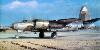
| London Stansted Airport FeatureType : airport Elevation : 100 Lat/Lng : 51.8903 / 0.2386 | London Stansted Airport is an international airport located at Stansted Mountfitchet in the district of Uttlesford in Essex, northeast of Central London and from the Hertfordshire border. London Stansted currently serves over 170 destinations across Europe, North Africa, Western Asia, with more (...) |
| 3 | 
| British Library FeatureType : landmark Elevation : 27 Lat/Lng : 51.5294 / -0.1269 | The British Library is the national library of the United Kingdom. British Library. Retrieved on 17 April 2014. and the largest national library in the world by number of items catalogued. It is estimated to contain 150–200 million+ items from many countries (...) |
| 4 | 
| Manchester Airport FeatureType : landmark Elevation : 76 Lat/Lng : 53.3537 / -2.2749 | Manchester Airport (Occasionally referred to as Manchester Ringway International Airport) is an international airport in Ringway, Greater Manchester, England, south-west of Manchester city centre. In 2016, it was the third busiest airport in the United Kingdom in terms of passenger numbers and the (...) |
| 5 | 
| St Kilda, Scotland FeatureType : isle Elevation : 267 Lat/Lng : 57.8178 / -8.5811 | St Kilda is an isolated archipelago situated west-northwest of North Uist, in the North Atlantic Ocean. It contains the westernmost islands of the Outer Hebrides of Scotland. The largest island is Hirta, whose sea cliffs are the highest in the United Kingdom (...) |
| 6 | 
| Birmingham FeatureType : city Elevation : 141 Lat/Lng : 52.4831 / -1.8936 | Birmingham is the second-most populous city in the United Kingdom, after London, and the most populous city in the English Midlands. With an estimated population of 1,137,100 , Birmingham is the cultural, social, financial and commercial centre of the Midlands (...) |
| 7 | 
| Shetland FeatureType : adm1st Lat/Lng : 60.3038 / -1.2689 | Shetland , also called the Shetland Islands and formerly Zetland, is a subarctic archipelago of Scotland that lies northeast of Great Britain. The islands lie some to the northeast of Orkney, from the Scottish mainland and southeast of the Faroe Islands (...) |
| 8 | 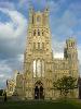
| Ely, Cambridgeshire FeatureType : null Elevation : 21 Lat/Lng : 52.3996 / 0.262 | Ely is a cathedral city in Cambridgeshire, England, about north-northeast of Cambridge and about by road from London. Æthelthryth (also known as Etheldreda) founded an abbey at Ely in 673; the abbey was destroyed in 870 by Danish invaders and was rebuilt by Æthelwold, Bishop of Winchester, in 970 (...) |
| 9 | 
| The Championships, Wimbledon FeatureType : landmark Elevation : 30 Lat/Lng : 51.4337 / -0.214 | The Championships, Wimbledon, commonly known simply as Wimbledon, is the oldest tennis tournament in the world. It has been held at the All England Club in Wimbledon, London, since 1877 and is played on outdoor grass courts (...) |
| 10 | 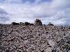
| Ben Nevis FeatureType : mountain Elevation : 1335 Lat/Lng : 56.7969 / -5.0035 | Ben Nevis is the highest mountain in the British Isles. Standing at above sea level, it is at the western end of the Grampian Mountains in the Lochaber area of the Scottish Highlands, close to the town of Fort William (...) |
| 11 | 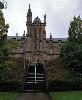
| Derry FeatureType : null Elevation : 30 Lat/Lng : 54.9958 / -7.3074 | Derry, officially Londonderry , is the second-largest city in Northern Ireland and the fourth-largest city on the island of Ireland.. Retrieved 1 November 2008. The name Derry is an anglicisation of the Old Irish name Daire (modern Irish: Doire) meaning "oak grove" (...) |
| 12 | 
| Isle of Lewis FeatureType : isle Elevation : 93 Lat/Lng : 58.1918 / -6.6022 | Lewis is the northern part of Lewis and Harris, the largest island of the Western Isles or Outer Hebrides archipelago in Scotland. It is also known as the Isle of Lewis, as the two parts are frequently referred to as if they were separate islands. The total area of Lewis is (...) |
| 13 | 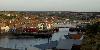
| Whitby FeatureType : null Elevation : 37 Lat/Lng : 54.4858 / -0.6206 | Whitby is a seaside town, port and civil parish in the Scarborough borough of North Yorkshire, England. Situated on the east coast of Yorkshire at the mouth of the River Esk, Whitby has a maritime, mineral and tourist heritage (...) |
| 14 | 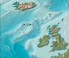
| Rockall FeatureType : isle Elevation : 0 Lat/Lng : 57.5963 / -13.6873 | Rockall is a British uninhabited granite islet located within the exclusive economic zone (EEZ) of the United Kingdom,. Oireachtas, Dublin, 24 March 2011. Retrieved 5 April 2018. situated in the North Atlantic Ocean (...) |
| 15 | 
| Bournemouth FeatureType : null Elevation : 21 Lat/Lng : 50.7178 / -1.8794 | Bournemouth is a large coastal resort town on the south coast of England to the east of the Jurassic Coast, a World Heritage Site, long. According to the 2011 census, the town has a population of 183,491 making it the largest settlement in Dorset (...) |
| 16 | 
| Orkney FeatureType : isle Elevation : 29 Lat/Lng : 59.0 / -3.0 | Orkney , also known as the Orkney Islands, is an archipelago in the Northern Isles of Scotland, situated off the north coast of Great Britain. Orkney is 16 kilometres (10 mi) north of the coast of Caithness and comprises approximately 70 islands, of which 20 are inhabited.Haskell-Smith (2004) pp (...) |
| 17 | 
| Kingston upon Hull FeatureType : city Elevation : 11 Lat/Lng : 53.7443 / -0.3325 | Kingston upon Hull, usually abbreviated to Hull, is a port city and unitary authority in the East Riding of Yorkshire, England. It lies upon the River Hull at its confluence with the Humber Estuary, 25 miles (40 km) inland from the North Sea, with a population of (...) |
| 18 | 
| Jura, Scotland FeatureType : isle Lat/Lng : 55.9596 / -5.9113 | Jura is an island in the Inner Hebrides of Scotland, adjacent to and to the north-east of Islay. With an area of 36,692 hectares, or 142 square miles, and only 196 inhabitants recorded in the 2011 census, Jura is much more sparsely populated than neighbouring Islay, and is one of the least densely (...) |
| 19 | 
| Isles of Scilly FeatureType : isle Elevation : 23 Lat/Lng : 49.9212 / -6.2943 | The Isles of Scilly (; or ') is an archipelago off the southwestern tip of Cornwall. One of the islands, St Agnes, is the most southerly point in both England and the United Kingdom, being over further south than the most southerly point of the British mainland at Lizard Point (...) |
| 20 | 
| Parthenon FeatureType : landmark Elevation : 146 Lat/Lng : 37.9715 / 23.7267 | The Parthenon (; ; , Parthenónas) is a former temple on the Athenian Acropolis, Greece, dedicated to the goddess Athena, whom the people of Athens considered their patron. Construction began in 447 BC when the Athenian Empire was at the peak of its power (...) |
| 21 | 
| Exmoor FeatureType : landmark Elevation : 318 Lat/Lng : 51.1067 / -3.6114 | Exmoor is loosely defined as an area of hilly open moorland in west Somerset and north Devon in South West England. It is named after the River Exe, the source of which is situated in the centre of the area, two miles north-west of Simonsbath (...) |
| 22 | 
| Broadstairs FeatureType : null Elevation : 26 Lat/Lng : 51.3564 / 1.4392 | Broadstairs is a coastal town on the Isle of Thanet in the Thanet district of east Kent, England, about east of London. It is part of the civil parish of Broadstairs and St Peter's, which includes St Peter's, and had a population in 2011 of about 25,000 (...) |
| 23 | 
| Royal Pavilion FeatureType : landmark Elevation : 16 Lat/Lng : 50.8225 / -0.1375 | The Royal Pavilion, also known as the Brighton Pavilion, is a Grade I listed former royal residence located in Brighton, England. Beginning in 1787, it was built in three stages as a seaside retreat for George, Prince of Wales, who became the Prince Regent in 1811 (...) |
| 24 | 
| Ireland FeatureType : country Elevation : 109 Lat/Lng : 53.4622 / -7.7625 | Ireland (; ; Ulster-Scots:) is an island in the North Atlantic. It is separated from Great Britain to its east by the North Channel, the Irish Sea, and St George's Channel. Ireland is the second-largest island of the British Isles, the third-largest in Europe, and the twentieth-largest on Earth (...) |
| 25 | 
| Iquitos FeatureType : city Elevation : 101 Lat/Lng : -3.7551 / -73.2491 | Iquitos , also known as Iquitos City, is the capital city of Peru's Maynas Province and Loreto Region. The largest metropolis in the Peruvian Amazon, east of the Andes, it is the sixth most populous city of Peru. It is known as the "capital of the Peruvian Amazon" (...) |
| 26 | 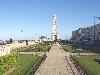
| Herne Bay, Kent FeatureType : null Elevation : 8 Lat/Lng : 51.3706 / 1.127 | Herne Bay is a seaside town in Kent, South East England, with a population of 38,563. On the south coast of the Thames Estuary, it is north of Canterbury and east of Whitstable. It neighbours the ancient villages of Herne and Reculver and is part of the City of Canterbury local government district (...) |
| 27 | 
| Livingston Island FeatureType : isle Lat/Lng : -62.6 / -60.5 | Livingston Island (Russian name Smolensk, British Antarctic Territory Gazetteer. UK Antarctic Place-names Committee (Narrative fragment: Ostrov Smolensk, so called by RAE after the Battle of Smolensk in 1812 (Bellingshausen, 1831a, sheet 62))) is an Antarctic island in the South Shetland Islands, (...) |
| 28 | 
| Sellafield FeatureType : landmark Elevation : 26 Lat/Lng : 54.4205 / -3.4975 | Sellafield is a nuclear fuel reprocessing and nuclear decommissioning site, close to the village of Seascale on the coast of the Irish Sea in Cumbria, England. The site is served by Sellafield railway station. Sellafield incorporates the original nuclear reactor site at Windscale, which is currently (...) |
| 29 | 
| Hexham FeatureType : null Elevation : 58 Lat/Lng : 54.971 / -2.101 | Hexham is a market town and civil parish in Northumberland, England, south of the River Tyne, and was the administrative centre for the Tynedale district from 1974 to 2009. In 2011, it had a population of 11,829 (...) |
| 30 | 
| Gosport FeatureType : null Elevation : 7 Lat/Lng : 50.7948 / -1.1243 | Gosport is a town in Hampshire on the south coast of England. At the 2011 Census, its population was 82,622. On a peninsula on the western side of Portsmouth Harbour, opposite the city of Portsmouth, it is linked to it by the Gosport Ferry. (...) |
| 31 | 
| Coll FeatureType : isle Elevation : 26 Lat/Lng : 56.6333 / -6.5572 | Coll Mac an Tàilleir (2003) p. 31 is an island located west of Mull in the Inner Hebrides of Scotland. Coll is known for its sandy beaches, which rise to form large sand dunes, for its corncrakes, and for Breacachadh Castle. It is in the council area of Argyll and Bute. (...) |
| 32 | 
| Rùm FeatureType : isle Elevation : 226 Lat/Lng : 56.9996 / -6.3344 | Rùm , a Scottish Gaelic name often anglicised to Rum, is one of the Small Isles of the Inner Hebrides, in the district of Lochaber, Scotland. For much of the 20th century the name became Rhum, a spelling invented by the former owner, Sir George Bullough, because he did not relish the idea of having (...) |
| 33 | 
| Eigg FeatureType : isle Elevation : 73 Lat/Lng : 56.9038 / -6.155 | Eigg is one of the Small Isles, in the Scottish Inner Hebrides. It lies to the south of the Skye and to the north of the Ardnamurchan peninsula. Eigg is long from north to south, and east to west. With an area of , it is the second largest of the Small Isles after Rùm (...) |
| 34 | 
| Foula FeatureType : isle Lat/Lng : 60.1333 / -2.0667 | Foula (pronounced //) in the Shetland archipelago of Scotland, is one of the United Kingdom’s most remote permanently inhabited islands. Owned since the turn of the 20th century by the Holbourn family, the island was the location for the film The Edge of the World (...) |
| 35 | 
| Gigha FeatureType : isle Elevation : -2 Lat/Lng : 55.6833 / -5.7667 | Gigha is a small island off the west coast of Kintyre in Scotland. The island forms part of Argyll and Bute and has a population of about 160 people. The climate is mild with higher than average sunshine hours and the soils are fertile. Gigha has been inhabited continuously since prehistoric times (...) |
| 36 | 
| Durham Tees Valley Airport FeatureType : null Elevation : 34 Lat/Lng : 54.5092 / -1.4294 | Durham Tees Valley Airport is an international airport located just east of Darlington in County Durham, north-east England, about south-west of Middlesbrough and south of Durham. The airport serves the North East and North Yorkshire, and is situated close to the village of Middleton St George in (...) |
| 37 | 
| HMS Belfast (C35) FeatureType : landmark Elevation : 3 Lat/Lng : 51.5067 / -0.0812 | HMS Belfast is a Town-class light cruiser that was built for the Royal Navy. She is now permanently moored as a museum ship on the River Thames in London and is operated by the Imperial War Museum. Construction of Belfast, the first ship in the Royal Navy to be named after the capital city of (...) |
| 38 | 
| Tintagel Castle FeatureType : landmark Elevation : 48 Lat/Lng : 50.6687 / -4.7619 | Tintagel Castle (meaning "fort of the constriction") is a medieval fortification located on the peninsula of Tintagel Island adjacent to the village of Tintagel, North Cornwall in the United Kingdom. The site was possibly occupied in the Romano-British period, as an array of artefacts dating to this (...) |
| 39 | 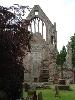
| Dryburgh Abbey FeatureType : landmark Elevation : 70 Lat/Lng : 55.5747 / -2.6497 | Dryburgh Abbey, near Dryburgh on the banks of the River Tweed in the Scottish Borders, was nominally founded on 10 November (Martinmas) 1150 in an agreement between Hugh de Morville, Constable of Scotland, and the Premonstratensian canons regular from Alnwick Abbey in Northumberland.Chron (...) |
| 40 | 
| St Patrick's Cathedral, Dublin FeatureType : landmark Elevation : 13 Lat/Lng : 53.3394 / -6.2714 | Saint Patrick's Cathedral in Dublin, Ireland, founded in 1191, is the National Cathedral of the Church of Ireland. With its spire, St. Patrick's is the tallest church (not Cathedral) in Ireland and the largest. Christ Church Cathedral, also a Church of Ireland cathedral in Dublin, is designated as (...) |
| 41 | 
| Banqueting House, Whitehall FeatureType : landmark Elevation : 15 Lat/Lng : 51.5044 / -0.1256 | The Banqueting House, Whitehall, is the grandest and best known survivor of the architectural genre of banqueting house and the only remaining component of the Palace of Whitehall. The building is important in the history of English architecture as the first structure to be completed in the (...) |
| 42 | 
| Eriskay FeatureType : null Elevation : 82 Lat/Lng : 57.0727 / -7.2908 | Eriskay , from the Old Norse for "Eric's Isle", is an island and community council area of the Outer Hebrides in northern Scotland. It lies between South Uist and Barra and is connected to South Uist by a causeway which was opened in 2001 (...) |
| 43 | German South West Africa FeatureType : landmark Elevation : 1665 Lat/Lng : -22.57 / 17.0836 | German South West Africa was a colony of the German Empire from 1884 until 1919. With an area of 835,100 km², it was one and a half times the size of the mainland German Empire in Europe at the time. The colony had a population of around 2,600 Germans (...) | |
| 44 | Inner Hebrides FeatureType : isle Elevation : 28 Lat/Lng : 56.5 / -6.0 | The Inner Hebrides (; Scottish Gaelic: Na h-Eileanan a-staigh, "the inner isles") is an archipelago off the west coast of mainland Scotland, to the south east of the Outer Hebrides. Together these two island chains form the Hebrides, which experience a mild oceanic climate (...) | |
| 45 | 
| Mingulay FeatureType : isle Elevation : 176 Lat/Lng : 56.8059 / -7.642 | Mingulay is the second largest of the Bishop's Isles in the Outer Hebrides of Scotland. Located south of Barra, it is known for its important seabird populations, including puffins, black-legged kittiwakes, and razorbills, which nest in the sea-cliffs,Murray (1973) p. 102 (...) |
| 46 | Devon FeatureType : landmark Elevation : 245 Lat/Lng : 50.7 / -3.824 | Devon , also known as Devonshire, which was formerly its common and official name, is a county of England, reaching from the Bristol Channel in the north to the English Channel in the south. It is part of South West England, bounded by Cornwall to the west, Somerset to the north east, and Dorset to (...) | |
| 47 | Outer Hebrides FeatureType : isle Elevation : 1 Lat/Lng : 57.76 / -7.02 | The Outer Hebrides , also known as the Western Isles (or '), ' ("islands of the strangers") or the Long Isle or the Long Island , is an island chain off the west coast of mainland Scotland. The islands are geographically with , one of the 32 unitary council areas of Scotland (...) | |
| 48 | Kirklees FeatureType : null Elevation : 195 Lat/Lng : 53.593 / -1.801 | Kirklees is a local government district of West Yorkshire, England, governed by Kirklees Council with the status of a metropolitan borough. The largest town and administrative centre of Kirklees is Huddersfield, and the district also includes Batley, Birstall, Cleckheaton, Denby Dale, Dewsbury, (...) | |
| 49 | Battle of Culloden FeatureType : event Elevation : 34 Lat/Lng : 57.4912 / -4.1322 | The Battle of Culloden was the final confrontation of the Jacobite rising of 1745. On 16 April 1746, the Jacobite forces of Charles Edward Stuart were decisively defeated by Hanoverian forces commanded by William Augustus, Duke of Cumberland, near Inverness in the Scottish Highlands (...) | |
| 50 | Apple Inc. FeatureType : landmark Elevation : 69 Lat/Lng : 37.3318 / -122.0312 | Apple Inc. is an American multinational technology company headquartered in Cupertino, California, that designs, develops, and sells consumer electronics, computer software, and online services. The company's hardware products include the iPhone smartphone, the iPad tablet computer, the Mac personal (...) | |
| 51 | Yorkshire FeatureType : adm2nd Elevation : 401 Lat/Lng : 54.0 / -2.0 | Yorkshire (; abbreviated Yorks), formally known as the County of York, is a historic county of Northern England and the largest in the United Kingdom. Due to its great size in comparison to other English counties, functions have been undertaken over time by its subdivisions, which have also been (...) | |
| 52 | Pan Am Flight 103 FeatureType : event Elevation : 74 Lat/Lng : 55.1156 / -3.3585 | Pan Am Flight 103 was a regularly scheduled Pan Am transatlantic flight from Frankfurt to Detroit via London and New York. On 21 December 1988, N739PA, the aircraft operating the transatlantic leg of the route, was destroyed by a bomb, killing all 243 passengers and 16 crew – a disaster known as the (...) | |
| 53 | Milford Haven FeatureType : null Elevation : 13 Lat/Lng : 51.7142 / -5.0427 | Milford Haven (meaning "mouth of the two Rivers Cleddau") is a town and community in Pembrokeshire, Wales. It is situated on the north side of the Milford Haven Waterway, an estuary forming a natural harbour that has been used as a port since the Middle Ages (...) | |
| 54 | Wendover FeatureType : null Elevation : 123 Lat/Lng : 51.768 / -0.7463 | Wendover is a market town and civil parish at the foot of the Chiltern Hills in Buckinghamshire, England. It is situated at the point where the main road across the Chilterns between London and Aylesbury intersects with the once important road along the foot of the Chilterns (...) | |
| 55 | Wessex FeatureType : adm2nd Elevation : 145 Lat/Lng : 51.2 / -2.0 | Wessex (; , the "kingdom of the West Saxons") was an Anglo-Saxon kingdom in the south of Great Britain, from 519 until England was unified by Æthelstan in the early 10th century. The Anglo-Saxons believed that Wessex was founded by Cerdic and Cynric, but this may be a legend (...) | |
| 56 | University of Birmingham FeatureType : null Elevation : 143 Lat/Lng : 52.4506 / -1.9306 | The University of Birmingham (informally Birmingham University) is a public research university located in Edgbaston, Birmingham, United Kingdom. It received its royal charter in 1900 as a successor to Queen's College, Birmingham (founded in 1825 as the Birmingham School of Medicine and Surgery) and (...) | |
| 57 | Pennines FeatureType : mountain Elevation : 887 Lat/Lng : 54.7028 / -2.4867 | The Pennines , also known as the Pennine Chain or Pennine Hills, are a range of mountains and hills in England separating North West England from Yorkshire and North East England. Often described as the "backbone of England", the Pennine Hills form a more-or-less continuous range stretching (...) | |
| 58 | Shropshire FeatureType : adm1st Elevation : 68 Lat/Lng : 52.7081 / -2.7544 | Shropshire (; alternatively Salop; abbreviated, in print only, Shrops; demonym Salopian). Acronyms.thefreedictionary.com. Retrieved on 25 August 2011. is a county in the West Midlands of England, bordering Wales to the west, Cheshire to the north, Staffordshire to the east, and Worcestershire and (...) | |
| 59 | North East England FeatureType : adm2nd Elevation : 99 Lat/Lng : 55.0 / -1.8667 | North East England is one of nine official regions of England at the first level of NUTS for statistical purposes. It covers Northumberland, County Durham, Tyne and Wear, and the former county of Cleveland now in North Yorkshire (...) | |
| 60 | Glamorgan FeatureType : adm2nd Elevation : 265 Lat/Lng : 51.6667 / -3.6667 | Glamorgan , or sometimes Glamorganshire, (or) is one of the thirteen historic counties of Wales and a former administrative county of Wales. It was originally an early medieval petty kingdom of varying boundaries known as Glywysing until taken over by the Normans as a lordship (...) | |
| 61 | 
| Boreray, St Kilda FeatureType : isle Elevation : 300 Lat/Lng : 57.8699 / -8.4901 | Boreray is an uninhabited island in the St Kilda archipelago in the North Atlantic. (...) |
| 62 | East Riding of Yorkshire FeatureType : adm2nd Elevation : 10 Lat/Lng : 53.8454 / -0.4275 | The East Riding of Yorkshire, or simply East Riding, is an area in Northern England and can refer either to the administrative county (Local Government Area) of the East Riding of Yorkshire which is a unitary authority, to the ceremonial county (Lieutenancy) of the East Riding of Yorkshire or to the (...) | |
| 63 | Polish Corridor FeatureType : null Elevation : 165 Lat/Lng : 54.35 / 18.3333 | The Polish Corridor , also known as Danzig Corridor, Corridor to the Sea or Gdańsk Corridor, was a territory located in the region of Pomerelia (Pomeranian Voivodeship, eastern Pomerania, formerly part of West Prussia), which provided the Second Republic of Poland (1920–1939) with access to the (...) | |
| 64 | Bayswater FeatureType : null Elevation : 32 Lat/Lng : 51.5095 / -0.193 | Bayswater is an area within the City of Westminster and the Royal Borough of Kensington and Chelsea in central London. It is a built-up district located west-north-west of Charing Cross, bordering the north of Kensington Gardens and having a population density of 17,500 per square kilometre (...) | |
| 65 | Tring FeatureType : city Elevation : 131 Lat/Lng : 51.7961 / -0.6592 | Tring is a small market town and civil parish in the Borough of Dacorum, Hertfordshire, England. It is situated in a gap passing through the Chiltern Hills, classed as an Area of Outstanding Natural Beauty, north-west of London, and linked to London by the old Roman road of Akeman Street, by the (...) | |
| 66 | RMS Lusitania FeatureType : landmark Lat/Lng : 51.4167 / -8.55 | RMS Lusitania was a British ocean liner and briefly the world's largest passenger ship. The ship was sunk on 7 May 1915 by a German U-boat off the southern coast of Ireland. The sinking presaged the United States declaration of war on Germany in 1917 (...) | |
| 67 | Banstead FeatureType : null Elevation : 160 Lat/Lng : 51.3223 / -0.2068 | Banstead is a residential town/village in the borough of Reigate and Banstead in Surrey, England, on the border with London, south of Sutton, west of Croydon and southeast of Kingston-upon-Thames and south of Central London. The county town, Guildford is west southwest (...) | |
| 68 | Greenwich Peninsula FeatureType : city Elevation : 2 Lat/Lng : 51.4981 / 0.0063 | Greenwich Peninsula is a district of south-east London, England, within the Royal Borough of Greenwich. The peninsula is bounded on three sides by a loop of the Thames, between the Isle of Dogs to the west and Silvertown to the east (...) | |
| 69 | Knighton, Powys FeatureType : null Elevation : 390 Lat/Lng : 52.3236 / -3.0285 | Knighton (or) is a small market town and community in central Powys (previously Radnorshire), Wales, on the Teme and the Wales-England border. A small part of the town including Knighton railway station is in Shropshire, England. This Anglo-Saxon settlement later became a Norman fortified town. (...) | |
| 70 | Appleby-in-Westmorland FeatureType : null Elevation : 133 Lat/Lng : 54.5779 / -2.4888 | Appleby-in-Westmorland is a market town and civil parish in the Eden district, in the county of Cumbria, in North West England. It is situated within a loop of the River Eden. In 2011 the parish had a population of 3,048 (...) | |
| 71 | The Ridgeway FeatureType : landmark Elevation : 196 Lat/Lng : 51.5633 / -1.35 | The Ridgeway is a ridgeway or ancient trackway described as Britain's oldest road. The section clearly identified as an ancient trackway extends from Wiltshire along the chalk ridge of the Berkshire Downs to the River Thames at the Goring Gap, part of the Icknield Way which ran, not always on the (...) | |
| 72 | Leiston Abbey FeatureType : null Elevation : 15 Lat/Lng : 52.2214 / 1.5776 | Leiston Abbey in Suffolk, England, was a religious house of Canons Regular following the Premonstratensian rule (White canons), dedicated to St. Mary.'House of Premonstratensian canons: Abbey of Leiston', in W. Page (ed.), A History of the County of Suffolk Vol. 2, ed. William Page (V.C.H (...) | |
| 73 | Peterhead FeatureType : null Elevation : 18 Lat/Lng : 57.5091 / -1.7832 | Peterhead (listen; ,According to , "The name Ceann Phàdraig is a fairly recent translation from English. The town was known as Inbhir Ùigidh, "mouth of the Ugie" or Inverugie, in the eastern Gaelic speaking areas.") is a town in Aberdeenshire, Scotland (...) | |
| 74 | River Ure FeatureType : null Elevation : 10 Lat/Lng : 54.0833 / -1.3333 | The River Ure is a river in North Yorkshire, England, approximately long from its source to the point where it changes name to the River Ouse. It is the principal river of Wensleydale, which is the only one of the major Dales now named after a village rather than its river (...) | |
| 75 | 
| Millport, Cumbrae FeatureType : city Elevation : 6 Lat/Lng : 55.7535 / -4.9256 | Millport (Scottish Gaelic: Port a' Mhuilinn) is the only town on the island of Great Cumbrae in the Firth of Clyde off the coast of North Ayrshire. The town is south from the Caledonian MacBrayne ferry slipway. Tourism is an important aspect of the economy (...) |
| 76 | Chiltern Hills FeatureType : mountain Elevation : 234 Lat/Lng : 51.6667 / -0.9167 | The Chiltern Hills form a chalk escarpment in South East England. They are known locally as "the Chilterns". A large portion of the hills was designated officially as an Area of Outstanding Natural Beauty in 1965. (...) | |
| 77 | Cromford and High Peak Railway FeatureType : null Elevation : 341 Lat/Lng : 53.1824 / -1.8065 | The Cromford and High Peak Railway (C&HPR) in Derbyshire, England, was completed in 1831, to carry minerals and goods between the Cromford Canal wharf at High Peak Junction and the Peak Forest Canal at Whaley Bridge (...) | |
| 78 | Brill, Buckinghamshire FeatureType : null Elevation : 190 Lat/Lng : 51.8204 / -1.0515 | Brill is a village and civil parish in Aylesbury Vale district in Buckinghamshire, England, close to the boundary with Oxfordshire. It is about north-west of Long Crendon and south-east of Bicester. It has a Royal charter to hold a weekly market, but has not done so for many years. (...) | |
| 79 | British Forces Broadcasting Service FeatureType : landmark Elevation : 84 Lat/Lng : 51.5882 / -0.5533 | The British Forces Broadcasting Service (BFBS) provides radio and television programmes for Her Majesty's Armed Forces, and their dependents worldwide. Editorial control is independent of the Ministry of Defence and the armed forces themselves (...) | |
| 80 | Hayle FeatureType : city Elevation : 26 Lat/Lng : 50.183 / -5.416 | Hayle ("estuary") is a small town, civil parish and cargo port in west Cornwall, England, United Kingdom. It is situated at the mouth of the Hayle River (which discharges into St Ives Bay) and is approximately seven miles (11 km) northeast of Penzance (...) | |
| 81 | Halesowen FeatureType : city Elevation : 128 Lat/Lng : 52.4486 / -2.0494 | Halesowen is a town in the Metropolitan Borough of Dudley, in the West Midlands, England. Historically in Worcestershire, the town is around from Birmingham city centre, and from Dudley town centre. The population of the town, as measured by the United Kingdom Census 2011, was 58,135 (...) | |
| 82 | North Berwick FeatureType : null Elevation : 26 Lat/Lng : 56.0569 / -2.7197 | North Berwick is a seaside town and former royal burgh in East Lothian, Scotland. It is situated on the south shore of the Firth of Forth, approximately east-northeast of Edinburgh. North Berwick became a fashionable holiday resort in the nineteenth century because of its two sandy bays, the East (...) | |
| 83 | Kirkcudbright FeatureType : null Elevation : 30 Lat/Lng : 54.832 / -4.0488 | Kirkcudbright, is a town and parish in Kirkcudbrightshire, of which it is traditionally the county town, within Dumfries and Galloway, Scotland. The town lies southwest of Castle Douglas and Dalbeattie at the mouth of the River Dee, some from the Irish Sea. (...) | |
| 84 | Firth of Clyde FeatureType : landmark Lat/Lng : 55.6791 / -5.0098 | The Firth of Clyde is an inlet of the Atlantic Ocean off the southwest coast of Scotland, named for the River Clyde which empties into it. It encloses the largest and deepest coastal waters in the British Isles, sheltered from the Atlantic Ocean by the Kintyre peninsula which encloses the outer (...) | |
| 85 | Loch Maree FeatureType : waterbody Elevation : 10 Lat/Lng : 57.6897 / -5.4575 | Loch Maree is a loch in Wester Ross in the Northwest Highlands of Scotland. At long and with a maximum width of , it is the fourth largest freshwater loch in Scotland; it is the largest north of Loch Ness. Its surface area is (...) | |
| 86 | Diocese of Chichester FeatureType : null Elevation : 19 Lat/Lng : 50.8363 / -0.7808 | The Diocese of Chichester is a Church of England diocese based in Chichester, covering Sussex. It was founded in 681 as the ancient Diocese of Selsey, which was based at Selsey Abbey, until the See was translated to Chichester in 1075 (...) | |
| 87 | Belvedere, London FeatureType : null Elevation : 6 Lat/Lng : 51.4911 / 0.1514 | Belvedere is a town in the London Borough of Bexley, in the historic county of Kent and ceremonial county of Greater London. It lies South of the River Thames, East of Abbey Wood and Thamesmead, West of Erith, and North of Bexleyheath. (...) | |
| 88 | 1996 Manchester bombing FeatureType : landmark Elevation : 55 Lat/Lng : 53.4833 / -2.2435 | The 1996 Manchester bombing was an attack carried out by the Provisional Irish Republican Army (IRA) on Saturday 15 June 1996. The IRA detonated a Lorry bomb on Corporation Street in the centre of Manchester, England (...) | |
| 89 | Cape Wrath FeatureType : landmark Elevation : 73 Lat/Lng : 58.6248 / -5.0015 | Cape Wrath (known as ' in Lewis) is a cape in the Durness parish of the county of Sutherland in the Highlands of Scotland. It is the most north-westerly point in mainland Britain. The cape is separated from the rest of the mainland by the Kyle of Durness and consists of of moorland wilderness known (...) | |
| 90 | Sherborne RFC FeatureType : landmark Elevation : 84 Lat/Lng : 50.9405 / -2.5111 | Sherborne Rugby Football Club is a rugby union club in Dorset in the south west of England. The club was established in 1980. It has a membership of 100 senior players and a further 300 boys and girls in the junior section (...) | |
| 91 | Molesey FeatureType : city Elevation : 9 Lat/Lng : 51.395 / -0.353 | Molesey is a suburban district comprising two large villages, East Molesey and West Molesey, in Surrey, England, just outside the edge of Greater London and situated on the south bank of the River Thames. East and West Molesey share a high street, and there is a second retail restaurant-lined street (...) | |
| 92 | Yell, Shetland FeatureType : isle Lat/Lng : 60.5994 / -1.1017 | Yell is one of the North Isles of Shetland, Scotland. In the 2011 census it had a usually resident population of 966. It is the second largest island in Shetland after the Mainland with an area of ,Penrith, James & Deborah (2007) Orkney & Shetland (part of The Scottish Islands series). Richmond (...) | |
| 93 | Woollen industry in Wales FeatureType : null Elevation : 14 Lat/Lng : 51.697 / -2.677 | The woollen industry in Wales was at times the country's most important industry, though it often struggled to compete with the better-funded woollen mills in the north of England, and almost disappeared during the 20th century. There is continued demand for quality Welsh woollen products (...) | |
| 94 | Alston, Cumbria FeatureType : null Elevation : 301 Lat/Lng : 54.8122 / -2.4387 | Alston is a small town in Cumbria, England, within the civil parish of Alston Moor on the River South Tyne. It shares the title of the 'highest market town in England', at about above sea level, with Buxton, Derbyshire (...) | |
| 95 | River Garnock FeatureType : null Elevation : 0 Lat/Lng : 55.6058 / -4.6958 | The River Garnock , the smallest of Ayrshire's six principal rivers,. Ayrshire Rivers Trust. Retrieved 13 May 2013. has its source on the southerly side of the Hill of Stake in the heart of the Clyde Muirshiel Regional Park (...) | |
| 96 | University of Hertfordshire FeatureType : edu Elevation : 84 Lat/Lng : 51.7531 / -0.2418 | The University of Hertfordshire is a university in Hertfordshire, United Kingdom. The university is based largely in Hatfield, Hertfordshire. Its antecedent institution, Hatfield Technical College, was founded in 1948 and was identified as one of 25 Colleges of Technology in the United Kingdom in (...) | |
| 97 | Flixton, Greater Manchester FeatureType : null Elevation : 21 Lat/Lng : 53.4419 / -2.3819 | Flixton is a village and electoral ward in the Metropolitan Borough of Trafford, Greater Manchester, England. The population of the ward at the 2011 census was 10,786. It lies about six miles (9.7 km) to the southwest of Manchester city centre, within the historic county boundaries of Lancashire (...) | |
| 98 | Rievaulx Abbey FeatureType : landmark Elevation : 88 Lat/Lng : 54.2577 / -1.1167 | Rievaulx Abbey was a Cistercian abbey in Rievaulx, situated near Helmsley in the North York Moors National Park, North Yorkshire, England. It was one of the great abbeys in England until it was seized under Henry VIII of England in 1538 during the dissolution of the monasteries (...) | |
| 99 | Ordnance Survey FeatureType : landmark Elevation : 12 Lat/Lng : 50.9378 / -1.4713 | Ordnance Survey (OS) is a national mapping agency in the United Kingdom which covers the island of Great Britain. Since 1 April 2015 it has operated as Ordnance Survey Ltd, a government-owned company, 100% in public ownership (...) | |
| 100 | St Buryan FeatureType : city Elevation : 121 Lat/Lng : 50.0755 / -5.6161 | St Buryan is a civil parish and village in Cornwall, England, United Kingdom. The village of St Buryan is situated approximately five miles (8 km) west of Penzance along the B3283 towards Land's End. Three further minor roads also meet at St Buryan, two link the village with the B3315 towards (...) | |
| 101 | Father Ted FeatureType : null Elevation : 79 Lat/Lng : 53.0098 / -9.03 | Father Ted is a British sitcom that was produced by Hat Trick Productions for Channel 4. Written by Irish writers Arthur Mathews & Graham Linehan and starring a predominantly Irish cast, it originally aired over three series from 21 April 1995 until 1 May 1998, including a Christmas special, for a (...) | |
| 102 | Eccles, Greater Manchester FeatureType : null Elevation : 32 Lat/Lng : 53.4824 / -2.339 | Eccles (; pop. 38,756 (2011)) is a town in Greater Manchester, England, west of Salford and west of Manchester city centre, between the M602 motorway to the north and the Manchester Ship Canal to the south. Historically part of Lancashire, Eccles grew up around the 13th-century Parish Church of St (...) | |
| 103 | Private Eye FeatureType : null Elevation : 37 Lat/Lng : 51.5147 / -0.1336 | Private Eye is a British fortnightly satirical and current affairs news magazine, founded in 1961. It is published in London and has been edited by Ian Hislop since 1986. The publication is widely recognised for its prominent criticism and lampooning of public figures (...) | |
| 104 | Wardenclyffe Tower FeatureType : landmark Elevation : 48 Lat/Lng : 40.9476 / -72.8982 | Wardenclyffe Tower (1901–1917), also known as the Tesla Tower, was an early experimental wireless transmission station designed and built by Nikola Tesla in Shoreham, New York in 1901–1902. Tesla intended to transmit messages, telephony and even facsimile images across the Atlantic to England and to (...) | |
| 105 | Ashdown Forest FeatureType : null Elevation : 66 Lat/Lng : 51.0167 / 0.0833 | Ashdown Forest is an ancient area of tranquil open heathland occupying the highest sandy ridge-top of the High Weald Area of Outstanding Natural Beauty. It is situated some south of London in the county of Sussex, England (...) | |
| 106 | Stalybridge FeatureType : null Elevation : 116 Lat/Lng : 53.4834 / -2.055 | Stalybridge is a town in Tameside, Greater Manchester, England, with a population of 23,731 at the 2011 Census. Historically a part of Cheshire, it is east of Manchester city centre and north-west of Glossop. With the construction of a cotton mill in 1776, Stalybridge became one of the first centres (...) | |
| 107 | Battle of Tewkesbury FeatureType : event Elevation : 18 Lat/Lng : 51.9864 / -2.1614 | The Battle of Tewkesbury, which took place on 4 May 1471, was one of the decisive battles of the Wars of the Roses. The forces loyal to the House of Lancaster were completely defeated by those of the rival House of York under their monarch, King Edward IV (...) | |
| 108 | Welsh Highland Railway FeatureType : landmark Elevation : 197 Lat/Lng : 53.0358 / -4.1261 | The Welsh Highland Railway (WHR) or Rheilffordd Eryri is a long, restored narrow gauge heritage railway in the Welsh county of Gwynedd, operating from Caernarfon to Porthmadog, and passing through a number of popular tourist destinations including Beddgelert and the Aberglaslyn Pass (...) | |
| 109 | Staffordshire Hoard FeatureType : landmark Elevation : 133 Lat/Lng : 52.6553 / -1.9069 | The Staffordshire Hoard is the largest hoard of Anglo-Saxon gold and silver metalwork . It consists of over 3,500 items, amounting to a total of of gold, of silver and some 3,500 pieces of garnet cloisonné jewellery (...) | |
| 110 | Cardiff Castle FeatureType : landmark Elevation : 13 Lat/Lng : 51.4833 / -3.1833 | Cardiff Castle is a medieval castle and Victorian Gothic revival mansion located in the city centre of Cardiff, Wales. The original motte and bailey castle was built in the late 11th century by Norman invaders on top of a 3rd-century Roman fort (...) | |
| 111 | Dunster FeatureType : null Elevation : 48 Lat/Lng : 51.1824 / -3.4461 | Dunster is a village, civil parish and former manor within the English county of Somerset, today just within the north-eastern boundary of the Exmoor National Park. It lies on the Bristol Channel coast south-southeast of Minehead and northwest of Taunton (...) | |
| 112 | National Museum of Iraq FeatureType : landmark Elevation : 40 Lat/Lng : 33.3283 / 44.3854 | The National Museum of Iraq (Arabic: المتحف العراقي) is a museum located in Baghdad, Iraq. Also known as the Iraq Museum, it contains precious relics from the Mesopotamian, Babylonian and Persian civilization. It was looted during and after the 2003 Invasion of Iraq (...) | |
| 113 | Mousehold Heath FeatureType : null Elevation : 38 Lat/Lng : 52.6454 / 1.3145 | Mousehold Heath is a freely accessible area of heathland and woodland which lies to the north-east of the medieval city boundary of Norwich, in eastern England. The name also refers to the much larger area of open heath that once extended from Norwich almost to the Broads, and which was kept free of (...) | |
| 114 | Dawson's Field hijackings FeatureType : null Elevation : 554 Lat/Lng : 32.1059 / 36.1567 | --> In September 1970, members of the Popular Front for the Liberation of Palestine (PFLP) hijacked four airliners bound for New York City and one for London. Three aircraft were forced to land at Dawson's Field, a remote desert airstrip near Zarqa, Jordan, formerly Royal Air Force Station Zerqa, (...) | |
| 115 | Galloway Hills FeatureType : null Elevation : 360 Lat/Lng : 55.12 / -4.41 | The Galloway hills are part of the Southern Uplands of Scotland, and form the northern boundary of western Galloway. They lie within the bounds of Galloway Forest Park, an area of some of largely uninhabited wild land, managed by the Forestry Commission (...) | |
| 116 | Holland House FeatureType : landmark Elevation : 28 Lat/Lng : 51.5025 / -0.2025 | Holland House, originally known as Cope Castle, was an early Jacobean country house built in 1605 by the diplomat Sir Walter Cope as the manor houseNeale, John Preston, Views of the Seats of Noblemen and Gentlemen, in England, Wales .. (...) | |
| 117 | Eglinton Country Park FeatureType : null Elevation : 11 Lat/Lng : 55.64 / -4.67 | Eglinton Country Park is located in the grounds of the old Eglinton Castle estate, Kilwinning, North Ayrshire, Scotland (map reference NS 3227 4220). Eglinton Park is situated in the parish of Kilwinning, part of the former district of Cunninghame, and covers an area of 400 hectares (of which are (...) | |
| 118 | Epsom railway station FeatureType : railwaystation Elevation : 51 Lat/Lng : 51.3343 / -0.2688 | Epsom railway station serves the town of Epsom in Surrey, England. It is located off Waterloo Road and is less than two minutes' walk from the town's high street. It is not in the London Oyster card zone unlike Epsom Downs or . It is down the line from . (...) | |
| 119 | Chester Zoo FeatureType : landmark Elevation : 35 Lat/Lng : 53.2267 / -2.8842 | Chester Zoo is a zoo at Upton by Chester, in Cheshire, England. Chester Zoo was opened in 1931 by George Mottershead and his family. It is one of the UK's largest zoos at . The zoo has a total land holding of approximately (...) | |
| 120 | Oxford Airport FeatureType : airport Elevation : 79 Lat/Lng : 51.8365 / -1.3202 | Oxford Airport , also known as Kidlington Airport, is a privately owned airport located near Kidlington in Cherwell District, Oxfordshire, northwest by north of Oxford, from Central London. It specialises in general and business aviation and is home to Oxford Aviation Academy, formerly Oxford (...) | |
| 121 | Operation Flavius FeatureType : event Elevation : 5 Lat/Lng : 36.1467 / -5.3503 | Operation Flavius (also referred to as the "Gibraltar killings") was a controversial military operation in which three members of the Provisional Irish Republican Army (IRA) were shot dead by the British Special Air Service (SAS) in Gibraltar on 6 March 1988 (...) | |
| 122 | Lin Biao FeatureType : null Elevation : 1029 Lat/Lng : 47.3167 / 110.65 | Lin Biao (December 5, 1907 – September 13, 1971) was a Marshal of the People's Republic of China who was pivotal in the Communist victory in the Chinese Civil War, especially in Northeast China. Lin was the general who commanded the decisive Liaoshen and Pingjin Campaigns, in which he co-led the (...) | |
| 123 | Mallerstang FeatureType : null Elevation : 257 Lat/Lng : 54.4085 / -2.3374 | Mallerstang is a civil parish in the extreme east of Cumbria, and, geographically, a at the head of the upper Eden Valley.A. Wainwright, Wainwright in the Limestone Dales, Guild Publishing, 1991 (pages 16–19) Originally part of Westmorland, it lies about south of the nearest town, Kirkby Stephen (...) | |
| 124 | Bethesda, Gwynedd FeatureType : null Elevation : 146 Lat/Lng : 53.179 / -4.06 | Bethesda is a town and community on the River Ogwen and the A5 road on the edge of Snowdonia, in Gwynedd, north-west Wales, colloquially called Pesda by the locals. It is the 5th largest Community in Gwynedd. (...) | |
| 125 | Britannia Yacht Club FeatureType : edu Elevation : 59 Lat/Lng : 45.3722 / -75.8003 | The Britannia Yacht Club (BYC) is a private social club, yacht club and tennis club based in Britannia, Ottawa, Ontario, Canada. It was founded in 1887 by a group of cottagers. The members have contributed to the sports of yachting and tennis (...) | |
| 126 | Skerryvore FeatureType : null Lat/Lng : 56.323 / -7.1144 | Skerryvore (from the Gaelic An Sgeir Mhòr meaning "The Great Skerry") is a remote reef that lies off the west coast of Scotland, 12 miles (19 kilometres) south-west of the island of Tiree. Skerryvore is best known as the name given to the lighthouse on the skerry, built with some difficulty between (...) | |
| 127 | Rhossili FeatureType : city Elevation : 80 Lat/Lng : 51.5686 / -4.2869 | Rhossili is a small village and community on the southwestern tip of the Gower PeninsulaA Guide to Gower, published by the Gower Society, in Swansea. It is within an area designated as the first Area of Outstanding Natural Beauty in the United Kingdom (...) | |
| 128 | Shere FeatureType : null Elevation : 85 Lat/Lng : 51.2206 / -0.4687 | Shere is a village in the Guildford district of Surrey, England east south-east of Guildford and west of Dorking, centrally bypassed by the A25. It is a small still partly agricultural village chiefly set in the wooded 'Vale of Holmesdale' between the North Downs and Greensand Ridge with many (...) | |
| 129 | Verney Junction railway station FeatureType : railwaystation Elevation : 91 Lat/Lng : 51.9406 / -0.93 | Verney Junction was an isolated railway station at a four-way railway junction in Buckinghamshire, open from 1868 to 1968; a junction existed through the site without a station from 1851. The first line to open on the site was the Buckinghamshire Railway, which opened a line from Bletchley to (...) | |
| 130 | Lobster (magazine) FeatureType : null Elevation : 65 Lat/Lng : 53.143 / -2.3775 | Lobster is a magazine that is interested primarily in the influence of intelligence and security services on politics and world trade, what it calls "deep politics" or "parapolitics". It combines the examination of conspiracy theories and contemporary history (...) | |
| 131 | Braidfauld FeatureType : null Elevation : 19 Lat/Lng : 55.8431 / -4.1831 | Braidfauld was the 45th ward in the City of Glasgow, Scotland, prior to the re-organization into multi-member wards. It is bounded on the south by the River Clyde (along which is a pleasant walkway) and on the north by (mostly) Tollcross Road (...) | |
| 132 | Anglezarke FeatureType : null Elevation : 223 Lat/Lng : 53.649 / -2.574 | Anglezarke is a sparsely populated civil parish in the Borough of Chorley in Lancashire, England. It is dominated by reservoirs that were built to supply water to Liverpool, and a large expanse of moorland with evidence of Bronze Age settlements (...) | |
| 133 | Boddam, Aberdeenshire FeatureType : null Elevation : 23 Lat/Lng : 57.4708 / -1.7801 | Boddam is a coastal village in Aberdeenshire, Scotland. It is north of Aberdeen and south of Peterhead. Sea cliffs rise to , south of the village: a coastal path leads along these to the Bullers of Buchan. The adjoining settlement, on the Aberdeen to Peterhead road, was for many years known simply (...) | |
| 134 | Sizewell nuclear power stations FeatureType : null Elevation : 26 Lat/Lng : 52.215 / 1.6197 | The Sizewell nuclear power stations are two nuclear power stations located near the small fishing village of Sizewell in Suffolk, England. Sizewell A, with two magnox reactors, is now in the process of being decommissioned, while Sizewell B has a single pressurised water reactor and is the UK's (...) | |
| 135 | Micheldever FeatureType : null Elevation : 80 Lat/Lng : 51.1486 / -1.2656 | Micheldever is a village in Hampshire, England, situated north of Winchester. It lies upon the River Dever . The river, and village, formerly part of Stratton Park, lie on a Hampshire grass downland, underlain with chalk and flint (...) | |
| 136 | Middleton, Leeds FeatureType : city Elevation : 136 Lat/Lng : 53.7428 / -1.5526 | Middleton is a largely residential suburb of Leeds in West Yorkshire, England and historically a village in the West Riding of Yorkshire. It is situated on a hill south of Leeds city centre and north north-west of London (...) | |
| 137 | VISTA (telescope) FeatureType : null Elevation : 2513 Lat/Lng : -24.6158 / -70.3975 | The VISTA (Visible and Infrared Survey Telescope for Astronomy) is a wide-field reflecting telescope with a 4.1 metre mirror, located at the Paranal Observatory in Chile. It is operated by the European Southern Observatory and started science operations in December 2009 (...) | |
| 138 | Dreamland Margate FeatureType : null Elevation : 7 Lat/Lng : 51.3863 / 1.3759 | Dreamland Margate is an amusement park and entertainment centre based on a traditional English seaside funfair located at Margate, Kent, England. The site of the park was first used for amusement rides in 1880, although the Dreamland name was not used until 1920 when the park's Grade II* listed (...) | |
| 139 | St Padarn's Church, Llanbadarn Fawr FeatureType : null Elevation : 19 Lat/Lng : 52.409 / -4.061 | Saint Padarn's Church is a parish church of the Church in Wales, and the largest mediaeval church in mid-Wales. Founded in the early sixth century, St Padarn's Church has gone through many changes, from a Welsh monastic centre (a clas), a Benedictine priory, a clas again, a royal rectory, a church (...) | |
| 140 | White House Farm murders FeatureType : event Elevation : 20 Lat/Lng : 51.7591 / 0.8032 | The White House Farm murders took place near the village of Tolleshunt D'Arcy, Essex, England, during the night of 6–7 August 1985. Nevill and June Bamber were shot and killed inside their farmhouse, along with their adoptive daughter, Sheila Caffell, and Sheila's six-year-old twin sons, Daniel and (...) | |
| 141 | Lydford railway station FeatureType : railwaystation Elevation : 206 Lat/Lng : 50.6247 / -4.1211 | Lydford railway station was a junction at Lydford between the Great Western Railway (GWR) and London and South Western Railway (LSWR) situated in a remote part of north-west Dartmoor in Devon, England. (...) | |
| 142 | Colonist (1861) FeatureType : landmark Lat/Lng : -33.8559 / 151.2386 | Colonist was a general cargo and passenger schooner built in 1861 at Dumbarton Scotland by Denny & Rankine. It spent nearly 30 years plying the Western Pacific-based out of Sydney. It wrecked and later re-floated on the remote Elizabeth Reef 550 km from New South Wales, as well as being involved in (...) | |
| 143 | Little Chalfont FeatureType : null Elevation : 123 Lat/Lng : 51.667 / -0.56 | Little Chalfont is a village and civil parish in the Chiltern district of Buckinghamshire, England. It is one of a group of villages known collectively as The Chalfonts, which also comprises Chalfont St Giles and Chalfont St Peter (...) | |
| 144 | Quintinshill rail disaster FeatureType : landmark Elevation : 33 Lat/Lng : 55.0147 / -3.0672 | The Quintinshill rail disaster was a multi-train rail crash which occurred on 22 May 1915 outside the Quintinshill signal box near Gretna Green in Dumfriesshire, Scotland. It resulted in the deaths of over 200 people, and is the worst rail disaster in British history (...) | |
| 145 | Harston FeatureType : null Elevation : 17 Lat/Lng : 52.138 / 0.081 | Harston is a village and civil parish in South Cambridgeshire, England, located around 5 miles (8 km) south of Cambridge. In 2011, it had a population of 1,740. (...) | |
| 146 | Crowle, Lincolnshire FeatureType : null Elevation : 10 Lat/Lng : 53.6074 / -0.8321 | Crowle is a small town in the civil parish of Crowle and Ealand, on the Isle of Axholme in North Lincolnshire, England. The civil parish had a population at the 2011 census of 4,828. It lies on the Stainforth and Keadby Canal and has a railway station. The town includes its suburb of Windsor (...) | |
| 147 | Chat Moss FeatureType : null Elevation : 26 Lat/Lng : 53.4629 / -2.4316 | Chat Moss is a large area of peat bog that makes up 30 per cent of the City of Salford, in Greater Manchester, England. North of the Manchester Ship Canal and River Mersey, to the west of Manchester, it occupies an area of about (...) | |
| 148 | RAF Kinloss FeatureType : airport Elevation : 6 Lat/Lng : 57.6504 / -3.5606 | RAF Kinloss is a former Royal Air Force station located near the village of Kinloss, on the Moray Firth in the north of Scotland. The RAF station opened on 1 April 1939 and served as a training establishment during the Second World War (...) | |
| 149 | St Margaret's Church, West Hoathly FeatureType : landmark Elevation : 179 Lat/Lng : 51.0766 / -0.0557 | St Margaret's Church (dedicated in full to St Margaret of Antioch) is an Anglican church in the village of West Hoathly in Mid Sussex, one of seven local government districts in the English county of West Sussex (...) | |
| 150 | Lindow Man FeatureType : landmark Elevation : 70 Lat/Lng : 53.3214 / -2.2711 | Lindow Man, also known as Lindow II and (in jest) as Pete Marsh, is the preserved bog body of a man discovered in a peat bog at Lindow Moss near Wilmslow in Cheshire, North West England. The human remains were found on 1 August 1984 by commercial peat-cutters (...) | |
| 151 | Land's End to John o' Groats FeatureType : null Elevation : 215 Lat/Lng : 54.6 / -3.1 | Land's End to John o' Groats is the traversal of the whole length of the island of Great Britain between two extremities, in the southwest and northeast. The traditional distance by road is and takes most cyclists 10 to 14 days; the record for running the route is nine days (...) | |
| 152 | Institute of Psychiatry, Psychology and Neuroscience FeatureType : landmark Elevation : 18 Lat/Lng : 51.4703 / -0.0898 | The Institute of Psychiatry, Psychology and Neuroscience (IoPPN) is a research institution dedicated to discovering what causes mental illness and diseases of the brain. In addition, its aim is to help identify new treatments for them and ways to prevent them in the first place (...) | |
| 153 | Pease Pottage FeatureType : null Elevation : 139 Lat/Lng : 51.0832 / -0.2009 | Pease Pottage is a small village in the Mid Sussex District of West Sussex, England. It lies on the southern edge of the Crawley built up area, in the civil parish of Slaugham. Pease Pottage is familiar to many drivers for its motorway service station, named after the village, which also serves as a (...) | |
| 154 | Gruinard Island FeatureType : null Elevation : 49 Lat/Lng : 57.8851 / -5.4734 | Gruinard Island (;G.M. Miller, BBC Pronouncing Dictionary of British Names (London: Oxford UP, 1971), p. 65.) is a small, oval-shaped Scottish island approximately long by wide, located in Gruinard Bay, about halfway between Gairloch and Ullapool (...) | |
| 155 | History of radio FeatureType : null Elevation : 179 Lat/Lng : 48.2097 / 16.3831 | The early history of radio is the history of technology that produces and uses radio instruments that use radio waves. Within the timeline of radio, many people contributed theory and inventions in what became radio. by Mary Bellis (ThoughtCo.com) Radio development began as "wireless telegraphy" (...) | |
| 156 | Liff, Angus FeatureType : null Elevation : 99 Lat/Lng : 56.4862 / -3.0863 | Liff is a village in Angus, Scotland, situated 4.5 miles west-north-west of Dundee on a south-facing slope two miles north of the River Tay. It had a population of 568 in 2011. Surrounded by farmland, it has been described as 'haunted by wood pigeons and the scent of wild garlic' and having a (...) | |
| 157 | St James's Hall FeatureType : landmark Elevation : 32 Lat/Lng : 51.5094 / -0.1367 | St. James's Hall was a concert hall in London that opened on 25 March 1858, designed by architect and artist Owen Jones, who had decorated the interior of the Crystal Palace.R. Elkin, Queen's Hall 1893-1941 (Ryder, London 1944), p. 16, note, says 1858 (...) | |
| 158 | Skellingthorpe FeatureType : null Elevation : 15 Lat/Lng : 53.2353 / -0.619 | Skellingthorpe is a village and civil parish in the North Kesteven district of Lincolnshire, England. The population of the civil parish at the 2011 census was 3,465. It is situated west from Lincoln city centre, and just outside the A46 Lincoln ring road (...) | |
| 159 | Tring railway station FeatureType : railwaystation Elevation : 127 Lat/Lng : 51.801 / -0.622 | Tring railway station is 1.5 miles outside the small town of Tring, close to the Grand Union Canal but actually nearer to the village of Aldbury in Hertfordshire, England. Situated on the West Coast Main Line, the station is now an important marshalling point for commuter trains from here for most (...) | |
| 160 | Kielder Forest FeatureType : forest Elevation : 185 Lat/Lng : 55.208 / -2.528 | Kielder Forest is a large forestry plantation in Northumberland, England, surrounding Kielder village and the Kielder Water reservoir. It is the largest man-made woodland in England with three-quarters of its covered by forest (...) | |
| 161 | RAF High Wycombe FeatureType : airport Elevation : 197 Lat/Lng : 51.6814 / -0.8019 | RAF High Wycombe is a Royal Air Force station, situated in the village of Walters Ash, near High Wycombe in Buckinghamshire, England. It houses Headquarters Air Command, and was originally designed to house RAF Bomber Command in the late 1930s (...) | |
| 162 | Shiant Isles FeatureType : isle Elevation : 109 Lat/Lng : 57.899 / -6.3641 | The Shiant Isles (; or) are a privately owned island group in the Minch, east of Harris in the Outer Hebrides of Scotland. They are five miles south east of Lewis.Keay, J. & Keay, J. (1994) Collins Encyclopaedia of Scotland. London. HarperCollins. (...) | |
| 163 | Stratton, Cornwall FeatureType : null Elevation : 48 Lat/Lng : 50.826 / -4.5288 | Stratton is a small town situated near the coastal resort of Bude in north Cornwall, England, UK. It was also the name of one of ten ancient administrative shires of Cornwall - see "Hundreds of Cornwall". A battle of the English civil war took place here on 16 May 1643 (...) | |
| 164 | Windlesham FeatureType : null Elevation : 54 Lat/Lng : 51.3651 / -0.6548 | Windlesham is a village in the Surrey Heath borough of Surrey, England and civil parish that covers Bagshot and Lightwater in the same borough. Its name derives from the Windle Brook which runs south of the village into Chobham and the common suffix 'ham', the Old English word for 'homestead' (...) | |
| 165 | Cairn Gorm FeatureType : null Elevation : 1147 Lat/Lng : 57.0841 / -3.6666 | Cairn Gorm (Cairngorm) (Gaelic: An Càrn Gorm, meaning Blue or Green Hill) is a mountain in the Scottish Highlands overlooking Strathspey and the town of Aviemore. At 1245 metres (4084 ft) it is the sixth-highest mountain in the United Kingdom (...) | |
| 166 | Harthill, Scotland FeatureType : null Elevation : 200 Lat/Lng : 55.8603 / -3.7493 | Harthill is a rural village in North Lanarkshire in Scotland, on the border with the neighbouring county of West Lothian about half-way between Glasgow and Edinburgh It lies on the River Almond about west of the small town of Whitburn. The closest major towns are Bathgate and Livingston (...) | |
| 167 | Swanton Novers FeatureType : null Elevation : 95 Lat/Lng : 52.8506 / 1.0001 | Swanton Novers is a village and a civil parish in the English county of Norfolk.OS Explorer Map 24 - Norfolk Coast Central. . The village is west-south-west of Cromer, north-north-west of Norwich and north-north-east of London. The village lies south-west of the town of Holt (...) | |
| 168 | Dubh Artach FeatureType : null Lat/Lng : 56.1324 / -6.6346 | Dubh Artach is a remote skerry of basalt rock off the west coast of Scotland lying west of Colonsay and south-west of the Ross of Mull. A lighthouse designed by Thomas Stevenson with a tower height of was erected between 1867 and 1872 with a shore station constructed on the isle of Erraid (...) | |
| 169 | Stainmore FeatureType : city Elevation : 274 Lat/Lng : 54.5279 / -2.2598 | Stainmore is a remote geographic area in the Pennines on the border of Cumbria, County Durham and North Yorkshire. The name is used for a civil parish in the Eden District of Cumbria, England, including the villages of North Stainmore and South Stainmore (...) | |
| 170 | St John the Baptist's Church, Crawley FeatureType : null Elevation : 78 Lat/Lng : 51.1139 / -0.1886 | St John the Baptist's Church is an Anglican church in Crawley, a town and borough in West Sussex, England. It is the parish church of Crawley, and is the oldest building in the town centre, dating from the 13th century—although many alterations have been made since, and only one wall remains of the (...) | |
| 171 | Jericho, Oxford FeatureType : city Elevation : 64 Lat/Lng : 51.7598 / -1.2658 | Jericho is an historic suburb of the English city of Oxford.Curl, 1977, pages 149–162 It consists of the streets bounded by the Oxford Canal, Worcester College, Walton Street and Walton Well Road. Located outside the old city wall, it was originally a place for travellers to rest if they had reached (...) | |
| 172 | Lyke Wake Walk FeatureType : landmark Elevation : 198 Lat/Lng : 54.3867 / -1.2815 | The Lyke Wake Walk is a challenge walk across the highest and widest part of the North York Moors National Park in north-east Yorkshire, England. Its associated club has its own social structure, culture and rituals based on the walk and Christian and folklore traditions from the area of North (...) | |
| 173 | Sutton, Kent FeatureType : null Elevation : 76 Lat/Lng : 51.1935 / 1.3219 | Sutton is a village and civil parish near Dover in Kent, England. In 1935 this village became a parish when the small settlements of Studdal, Sutton, Ashley, Little Mongeham and Maydensole joined to become the Parish of Sutton-by-Dover (...) | |
| 174 | Downing Street mortar attack FeatureType : event Elevation : 20 Lat/Lng : 51.5036 / -0.128 | The Downing Street mortar attack was carried out by the Provisional Irish Republican Army (IRA) on 7 February 1991. The IRA launched homemade mortar shells at 10 Downing Street, London, the official residence of the Prime Minister of the United Kingdom (...) | |
| 175 | Mortehoe FeatureType : city Elevation : 106 Lat/Lng : 51.1853 / -4.2089 | Mortehoe is a village and former manor on the north coast of Devon, England. It lies 10 miles north-west of Barnstaple, near Woolacombe and Lee Bay, and is sited in a valley within the hilly sand-dune-like land behind Morte Point. The parish population at the 2011 census was 1,637 (...) | |
| 176 | Kirkliston FeatureType : null Elevation : 37 Lat/Lng : 55.9536 / -3.4029 | Kirkliston is a small town and parish to the west of Edinburgh, Scotland, historically within the county of West Lothian. It lies on high ground immediately north of a northward loop of the Almond, on the old road between Edinburgh and Linlithgow (the B9080, now cut off by Edinburgh Airport), having (...) | |
| 177 | Collingham, Nottinghamshire FeatureType : city Elevation : 13 Lat/Lng : 53.1478 / -0.7592 | Collingham is a village and civil parish in Nottinghamshire, England. The population (including Brough) at the 2011 Census was 2,738. Collingham is located on the banks of the River Trent on the A1133 main road, just off the A46 (...) | |
| 178 | Taff Trail FeatureType : null Elevation : 159 Lat/Lng : 51.6964 / -3.3471 | The Taff Trail is a popular walking and cycle path that runs for between Cardiff Bay and Brecon in Wales. It is so named because it follows the course of the River Taff. Along much of its length, it follows the National Cycle Network Route 8 (Lôn Las Cymru) that continues to Holyhead, and is (...) | |
| 179 | Spurn FeatureType : city Elevation : 8 Lat/Lng : 53.576 / 0.1115 | Spurn is a narrow sand tidal island located off the tip of the coast of the East Riding of Yorkshire, England that reaches into the North Sea and forms the north bank of the mouth of the Humber Estuary. Prior to a severe storm in February 2017, which damaged part of the sandbank, Spurn was a spit (...) | |
| 180 | Nenthead FeatureType : null Elevation : 446 Lat/Lng : 54.7892 / -2.3421 | The small village of Nenthead in the county of Cumbria is one of England's highest villages, at around .http://www.eden.gov.uk/EasySiteWeb/GatewayLink.aspx?alId=30614Cached It was not built until the middle of the 18th century and was one of the earliest purpose-built industrial villages in Britain (...) | |
| 181 | Warrenpoint ambush FeatureType : city Elevation : 6 Lat/Lng : 54.1115 / -6.2788 | The Warrenpoint ambushBowyer Bell, John: The IRA, 1968–2000: Analysis of a Secret Army. Taylor & Francis, 2000. p. 305. Faligot, Roger: Britain's Military Strategy in Ireland: The Kitson Experiment. Zed Press, 1983, p. 142. Ellison, Graham, and Smyth, Jim: The Crowned Harp: Policing Northern Ireland (...) | |
| 182 | Cunninghamhead Estate FeatureType : landmark Elevation : 75 Lat/Lng : 55.6363 / -4.51 | The Cunninghamhead Estate is in the 21st century mainly a residential caravan park with two private residences near Irvine, Scotland. It was once a private estate, owned by a sequence of recorded families since around 1418 (...) | |
| 183 | Rhosydd Quarry FeatureType : null Elevation : 454 Lat/Lng : 52.9966 / -3.9905 | Rhosydd Quarry is a slate mine northeast of Porthmadog in North Wales. Small-scale working of the site began in the 1830s, but was hampered by the remote location, and the lack of a transport system to carry the slates to markets (...) | |
| 184 | Epping Forest District FeatureType : adm2nd Elevation : 110 Lat/Lng : 51.698 / 0.1102 | Epping Forest is a local government district in Essex, England. It is named after, and contains a large part of, Epping Forest. The district, though wholly within the county of Essex, is partly contiguous with Greater London to the south and southwest, and the area around Buckhurst Hill, Chigwell, (...) | |
| 185 | Molland FeatureType : null Elevation : 189 Lat/Lng : 51.042 / -3.704 | Molland is a small village, civil parish, dual ecclesiastical parish with Knowstone, located in the foothills of Exmoor in Devon, England. It lies within the North Devon local government district. At the time of the 2001 Census, the village had 203 inhabitants (...) | |
| 186 | Easton Neston house FeatureType : landmark Elevation : 113 Lat/Lng : 52.1373 / -0.9758 | Easton Neston is a large grade I listed country house in the parish of Easton Neston near Towcester in Northamptonshire, England. It was built by William Fermor, 1st Baron Leominster (1648–1711), in the Baroque style to the design of the architect Nicholas Hawksmoor (...) | |
| 187 | Achanalt railway station FeatureType : railwaystation Elevation : 120 Lat/Lng : 57.6097 / -4.9137 | Achanalt railway station is a remote railway station on the Kyle of Lochalsh Line, serving the village of Achanalt in the north of Scotland. The station is from , and has a single platform which is long enough for a three-coach train. It is the least used station on the line. (...) | |
| 188 | Shotesham FeatureType : null Elevation : 35 Lat/Lng : 52.5437 / 1.3216 | Shotesham is a village in South Norfolk which lies approximately 5 miles south of Norwich. It sits next to Stoke Holy Cross and Saxlingham Nethergate in the valley of the River Tas. It covers an area of and had a population of 539 in 210 households at the 2001 census, increasing to 562 in 227 (...) | |
| 189 | Besthorpe, Norfolk FeatureType : null Elevation : 38 Lat/Lng : 52.517 / 1.033 | Besthorpe is a village and civil parish in the Breckland district of Norfolk, England, about a mile east of Attleborough, on the A11 road. According to the 2001 census it had a population of 561, increasing to 778 at the 2011 Census (...) | |
| 190 | West Moors FeatureType : null Elevation : 17 Lat/Lng : 50.824 / -1.8885 | West Moors is a village in East Dorset, England, on the northern fringe of the Poole-Bournemouth conurbation, just outside the larger settlements of Ferndown and Verwood. The parish of West Moors had an estimated population of 7,400 in 2004, increasing to 7,561 for both the parish and electoral ward (...) | |
| 191 | Berney Arms railway station FeatureType : railwaystation Elevation : 0 Lat/Lng : 52.59 / 1.6308 | Berney Arms railway station is on the Wherry Lines in the east of England, serving the remote settlement of Berney Arms on the Halvergate Marshes in Norfolk. It is from and is on a loop between and . It is managed by Greater Anglia, which also operates all trains serving the station (...) | |
| 192 | Offley FeatureType : null Elevation : 159 Lat/Lng : 51.9234 / -0.3446 | Offley is a civil parish in the English county of Hertfordshire, between Hitchin and Luton. The main village is Great Offley, and the parish also contains the nearby hamlets of Little Offley and The Flints. In the south-west of the parish, near Luton, there are the hamlets of Cockernhoe, Mangrove (...) | |
| 193 | Normandy, Surrey FeatureType : null Elevation : 55 Lat/Lng : 51.2575 / -0.6747 | Normandy is a civil parish of in the borough of Guildford in Surrey, England and the name of the largest village in that parish. Almost surrounded by its hill ranges, Normandy is in the plain west of Guildford, straddles the A323 'Aldershot Road' and is north of the narrowest part the North Downs (...) | |
| 194 | Archaeology Data Service FeatureType : edu Elevation : 21 Lat/Lng : 53.9624 / -1.0866 | The Archaeology Data Service (ADS) is an open access digital archive for archaeological research outputs. It is located in The King's Manor, at the University of York. Originally intended to curate digital outputs from archaeological researchers based in the UK's Higher Education sector, the ADS (...) | |
| 195 | Tulloch railway station FeatureType : railwaystation Elevation : 203 Lat/Lng : 56.8841 / -4.7012 | Tulloch railway station is a rural railway station in the remote Tulloch area of the Highland region of Scotland. This station is on the West Highland Line, north of . (...) | |
| 196 | Little London, Shropshire FeatureType : null Elevation : 298 Lat/Lng : 52.492 / -2.725 | Little London is the name of two hamlets in Shropshire, England. One hamlet is situated near Alveley. It borders with Arley, Worcestershire and its partial woodland forms the outskirts of the Wyre Forest. This Little London sits on an unclassified road which forms part of the access route to Alveley (...) | |
| 197 | Rannoch railway station FeatureType : railwaystation Elevation : 301 Lat/Lng : 56.6859 / -4.577 | Rannoch railway station, on the West Highland Line, serves the area of Rannoch in Perth and Kinross, Scotland. Its remote location on Rannoch Moor is picturesque and makes it attractive to walkers. The station has a tea room and visitor centre (...) | |
| 198 | Moffat Hills FeatureType : null Elevation : 602 Lat/Lng : 55.423 / -3.384 | The Moffat hills are a range of hills in the Southern Uplands of Scotland. They form a distinctly triangular shape with a west facing side, a north facing side, and a south-east facing side. It is 17 kilometres from east to west across this triangle and some 16 kilometres north to south (...) | |
| 199 | Sholing FeatureType : null Elevation : 35 Lat/Lng : 50.9001 / -1.3551 | Sholing, previously Scholing, is a district on the eastern side of the city of Southampton in Southern England. It is located between the districts of Bitterne, Thornhill and Woolston. Various explanations from where the name derives but the most popular is that "Sholing" derives from the (...) | |
| 200 | St Jerome's Church, Llangwm FeatureType : null Elevation : 52 Lat/Lng : 51.696 / -2.83 | The Church of St Jerome stands in the settlement of Llangwm Uchaf, (upper) Llangwm, in a remote part of Monmouthshire, Wales. Originally constructed in the twelfth century, in an Early English style, it was heavily restored in the nineteenth century (...) | |
 by
by