| 23 records found in wikipedia | |||
| 1 | 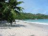
| Seychelles  FeatureType : country Elevation : 9 Lat/Lng : -7.0675 / 52.7344 | Seychelles (; French:), officially the Republic of Seychelles (; Creole: Repiblik Sesel), is an archipelago country in the Indian Ocean. The capital of the 115-island country, Victoria, lies east of mainland East Africa (...) |
| 2 | 
| Geography of Seychelles FeatureType : null Elevation : 411 Lat/Lng : -4.6667 / 55.4667 | The Seychelles is a small island nation located in the Indian Ocean northeast of Madagascar and about east of Kenya. Seychelles lies between approximately 4ºS and 10ºS and 46ºE and 54ºE. The nation is an archipelago of 115 tropical islands, some granite and some coral (...) |
| 3 | 
| Réunion FeatureType : adm1st Elevation : 1715 Lat/Lng : -21.1144 / 55.5325 | Réunion (; previously Île Bourbon) is an overseas department and region of France and an island in the Indian Ocean, east of Madagascar and southwest of Mauritius. , it had a population of 865,826. It has the highest per capita GDP in the Indian Ocean (...) |
| 4 | 
| Mascarene Islands FeatureType : isle Lat/Lng : -20.7167 / 56.6167 | The Mascarene Islands or Mascarenes or Mascarenhas Archipelago is a group of islands in the Indian Ocean east of Madagascar consisting of Mauritius, Réunion and Rodrigues. Their name derives from the Portuguese navigator Pedro Mascarenhas, who first visited them in April 1512 (...) |
| 5 | 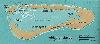
| Aldabra FeatureType : isle Lat/Lng : -9.4167 / 46.4167 | Aldabra is the world's second-largest coral atoll. It is situated in the Aldabra Group of islands in the Indian Ocean that are part of the Outer Islands of the Seychelles, with a distance of 1,120 km (700 mi) southwest of the capital, Victoria, on Mahé Island. (...) |
| 6 | 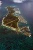
| Desroches Island FeatureType : isle Elevation : 18 Lat/Lng : -5.6833 / 53.6833 | Desroches Island or Île Desroches is the main island of the Amirante Islands, part of the Outer Islands of the Seychelles. It is located 227 km southwest of Victoria, Seychelles. It is 5.5 km long and has a land area of 4.027 km2. Along its circumference of 13 km is a beach of fine sand (...) |
| 7 | 
| Mauritius FeatureType : country Elevation : 177 Lat/Lng : -20.2 / 57.5 | Mauritius , officially the Republic of Mauritius , is an island nation in the Indian Ocean about 2,000 kilometres (1,200 mi) off the southeast coast of the African continent. The country includes the islands of Mauritius and Rodrigues, 560 kilometres (350 mi) east of Mauritius, and the outer islands (...) |
| 8 | 
| Poivre Atoll FeatureType : isle Lat/Lng : -5.7667 / 53.3167 | Poivre Islands are a group of islands in Seychelles, lying in the Outer Islands of Seychelles, with a distance of 268 km south of Victoria, Seychelles. (...) |
| 9 | 
| La Digue FeatureType : isle Elevation : 80 Lat/Lng : -4.3667 / 55.8333 | La Digue is the third largest inhabited island of the Seychelles in terms of population, lying east of Praslin and west of Felicite Island. In terms of size it is the fourth largest granitic island of Seychelles after Mahé, Praslin and Silhouette Island (...) |
| 10 | 
| Comoros FeatureType : country Lat/Lng : -12.1667 / 44.25 | The Comoros , officially the Union of the Comoros (Comorian: Udzima wa Komori, , '), is an island country in the Indian Ocean located at the northern end of the Mozambique Channel off the eastern coast of Africa between northeastern Mozambique, the french region of Mayotte and northwestern (...) |
| 11 | Mascarene Plateau FeatureType : null Lat/Lng : -12.0 / 61.0 | The Mascarene Plateau is a submarine plateau in the Indian Ocean, north and east of Madagascar. The plateau extends approximately , from the Seychelles in the north to Réunion in the south. The plateau covers an area of over of shallow water, with depths ranging from , plunging to to the abyssal (...) | |
| 12 | North Island, Seychelles FeatureType : isle Elevation : 26 Lat/Lng : -4.3967 / 55.2467 | North Island is a small granitic island (2.01 km²) in the Seychelles. (...) | |
| 13 | Roman Catholic Diocese of Saint-Denis de La Réunion FeatureType : city Elevation : 32 Lat/Lng : -20.8772 / 55.4488 | The Roman Catholic Diocese of Saint-Denis de La Réunion (; French: Diocèse de Saint-Denis de La Réunion) is a diocese of the Catholic Church located on the island of Réunion. It is immediately subject to the Holy See (...) | |
| 14 | Isle de France (Mauritius) FeatureType : null Elevation : 41 Lat/Lng : -20.1667 / 57.5167 | Isle de France (Île de France in modern French) was the name of the Indian Ocean island of Mauritius and its dependent territories between 1715 and 1810, when the area was under the French East India Company and part of France's empire. Under the French, the island witnessed major changes (...) | |
| 15 | Anonyme Island FeatureType : isle Lat/Lng : -4.65 / 55.5167 | Anonyme Island is a small granitic island (0.1 km²) in the Seychelles, lying 700 m off the east coast of Mahé, near the runway of the Seychelles International Airport. (...) | |
| 16 | Réunion hotspot FeatureType : null Elevation : 2128 Lat/Lng : -21.1 / 55.5 | The Réunion hotspot is a volcanic hotspot which currently lies under the island of Réunion in the Indian Ocean. The Chagos-Laccadive Ridge and the southern part of the Mascarene Plateau are volcanic traces of the Réunion hotspot. The hotspot is believed to have been active for over 65 million years (...) | |
| 17 | St. Brandon FeatureType : isle Lat/Lng : -16.5833 / 59.6167 | Saint Brandon, also known as the Cargados Carajos Shoals, is an Indian Ocean archipelago about northeast of Mauritius consisting of a number of sand banks, shoals and islets. Saint Brandon consists of five island groups, with about 28–40 islands and islets in total, depending on seasonal storms and (...) | |
| 18 | Special member state territories and the European Union FeatureType : null Elevation : 54 Lat/Lng : 57.9058 / 27.7132 | The special territories of the European Union are 31 territories of EU member states which, for historical, geographical, or political reasons, enjoy special status within or outside the European Union. The special territories divided themselves in two categories: 9 Outermost Regions (OMR) that form (...) | |
| 19 | Battle of Tamatave FeatureType : city Elevation : 9 Lat/Lng : -18.15 / 49.4167 | The Battle of Tamatave (sometimes called the Battle of Madagascar or the Action of 20 May 1811) was fought off Tamatave in Madagascar between British and French frigate squadrons during the Napoleonic Wars. The action was the final engagement of the Mauritius campaign of 1809–1811, and it saw the (...) | |
| 20 | Structure of the French Army in 1989 FeatureType : null Elevation : 165 Lat/Lng : 49.1167 / 6.1667 | The Order of Battle of the French Army in 1989 is given below. In 1977 the Army had changed its military organisation in accordance with a short war-fighting strategy in Europe, and divisions lost their component brigades (...) | |
| 21 | Islets of Mauritius FeatureType : null Elevation : 59 Lat/Lng : -19.85 / 57.7833 | The Islets of Mauritius includes nearly a hundred tiny islets and rocks scattered around the coast of Mauritius as well as Rodrigues. (...) | |
| 22 | Flic-en-Flac FeatureType : null Lat/Lng : -20.2742 / 57.3631 | Flic-en-Flac (Creole pronunciation:) is a small seaside town on the western part of the island of Mauritius in the district of Black River. The name most likely comes from an Old Dutch phrase, "Fried Landt Flaak", meaning free, flat land (...) | |
| 23 | Saltibus, Saint Lucia FeatureType : null Elevation : 242 Lat/Lng : 13.8006 / -60.9992 | Saltibus is located on southwestern side of the Island of Saint Lucia. It belongs to one of two of the 11 quarters, or sections of the island, which were sometimes called "districts", which is no longer under control of the British colonial government as of 1979 AD (...) | |
 by
by