| 467 records found in wikipedia | |||
| 1 | 
| Borneo  FeatureType : isle Elevation : 245 Lat/Lng : -0.1758 / 113.6864 | Borneo is the third-largest island in the world and the largest in Asia. At the geographic centre of Maritime Southeast Asia, in relation to major Indonesian islands, it is located north of Java, west of Sulawesi, and east of Sumatra (...) |
| 2 | 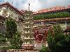
| Penang FeatureType : isle Elevation : 483 Lat/Lng : 5.4 / 100.2333 | Penang is a Malaysian state located on the northwest coast of Peninsular Malaysia, by the Malacca Strait. It has two parts: Penang Island, where the capital city, George Town, is located, and Seberang Perai (formerly Province Wellesley) on the Malay Peninsula (...) |
| 3 | 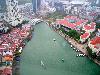
| Singapore FeatureType : city Elevation : 18 Lat/Lng : 1.35 / 103.85 | Singapore , officially the Republic of Singapore (Malay: ; Chinese: ; Tamil:), is a sovereign city-state and island country in Southeast Asia. It lies one degree north of the equator, at the southern tip of the Malay Peninsula, with Indonesia's Riau Islands to the south and Peninsular Malaysia to (...) |
| 4 | 
| Kota Kinabalu FeatureType : airport Elevation : 7 Lat/Lng : 5.9714 / 116.0952 | Kota Kinabalu (Jawi:), formerly known as Jesselton, is the state capital of Sabah, Malaysia and the capital of the Kota Kinabalu District. It is also the capital of the West Coast Division of Sabah. The city is located on the northwest coast of Borneo facing the South China Sea (...) |
| 5 | 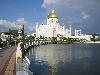
| Brunei FeatureType : country Elevation : 17 Lat/Lng : 4.4167 / 114.5833 | Brunei , officially the Nation of Brunei, the Abode of PeacePeter Haggett (ed). Encyclopedia of World Geography, Volume 1, Marshall Cavendish, 2001, . (Jawi:), is a country located on the north coast of the island of Borneo in Southeast Asia (...) |
| 6 | 
| Havana FeatureType : null Elevation : 17 Lat/Lng : 23.1388 / -82.3573 | Havana (; Spanish: La Habana) is the capital city, largest city, province, major port, and leading commercial center of Cuba. The city has a population of 2.1 million inhabitants, and it spans a total of – making it the largest city by area, the most populous city, and the fourth largest (...) |
| 7 | 
| Kedah FeatureType : adm1st Elevation : 6 Lat/Lng : 6.1283 / 100.363 | Kedah (; ; Jawi: قدح), also known by its honorific Darul Aman or "Abode of Peace", is a state of Malaysia, located in the northwestern part of Peninsular Malaysia. The state covers a total area of over 9,000 km², and it consists of the mainland and Langkawi (...) |
| 8 | 
| Kuching FeatureType : city Elevation : 14 Lat/Lng : 1.5485 / 110.3414 | Kuching , officially the City of Kuching, is the capital and the most populous city in the state of Sarawak in Malaysia. It is also the capital of Kuching Division. The city is situated on the Sarawak River at the southwest tip of the state of Sarawak on the island of Borneo and covers an area of (...) |
| 9 | 
| Malaysia FeatureType : country Elevation : 62 Lat/Lng : 3.1333 / 101.7 | Malaysia is a country in Southeast Asia. The federal constitutional monarchy consists of 13 states and three federal territories, separated by the South China Sea into two similarly sized regions, Peninsular Malaysia and Malaysian Borneo (...) |
| 10 | 
| Sandakan FeatureType : null Lat/Lng : 5.837 / 118.1148 | Sandakan (Jawi:) formerly known at various times as Elopura, is the capital of the Sandakan District in Sabah, Malaysia. It is the second largest town in Sabah after Kota Kinabalu. It is located on the east coast of the state in the administrative centre of Sandakan Division and was the former (...) |
| 11 | 
| Malacca City FeatureType : city Elevation : 11 Lat/Lng : 2.1943 / 102.2487 | Malacca City (Bandaraya Melaka), is the capital city of the Malaysian state of Malacca. As of 2010 it has a population of 484,885. It is the oldest Malaysian city on the Straits of Malacca, having become a successful entrepôt in the era of the Malacca Sultanate (...) |
| 12 | 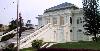
| Johor Bahru FeatureType : null Elevation : 35 Lat/Lng : 1.4833 / 103.7333 | Johor Bahru , formerly known as Tanjung Puteri or Iskandar Puteri, is the capital of the state of Johor, Malaysia. It is situated along the Straits of Johor at the southern end of Peninsular Malaysia. Johor Bahru has a population of 497,097, while its metropolitan area, with a population of (...) |
| 13 | 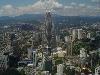
| Kuala Lumpur FeatureType : null Elevation : 42 Lat/Lng : 3.1473 / 101.6984 | Kuala Lumpur , officially the Federal Territory of Kuala Lumpur , or commonly known as KL, is the national capital of Malaysia as well as its largest city. The only global city in Malaysia, it covers an area of and has an estimated population of 1.73 million (...) |
| 14 | 
| Langkawi FeatureType : isle Elevation : 84 Lat/Lng : 6.3569 / 99.8005 | Langkawi, officially known as Langkawi, the Jewel of Kedah , is a district and an archipelago of 99 islands (+ 5 small islands visible only at low tide) in the Andaman Sea some 30 km off the mainland coast of northwestern Malaysia (...) |
| 15 | 
| George Town, Penang FeatureType : city Elevation : 10 Lat/Lng : 5.4167 / 100.3167 | George Town, the capital city of the Malaysian state of Penang, is located at the north-eastern tip of Penang Island. It is Malaysia's second largest city, with 708,127 inhabitants , while Greater Penang is the nation's second biggest conurbation with a population of 2,412,616 (...) |
| 16 | 
| Penang International Airport FeatureType : null Elevation : 0 Lat/Lng : 5.2969 / 100.2767 | Penang International Airport , within the city of George Town, is one of the busiest airports in Malaysia. The airport is located near Bayan Lepas at the southeastern tip of Penang Island, south of the city centre (...) |
| 17 | 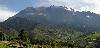
| Mount Kinabalu FeatureType : mountain Elevation : 4022 Lat/Lng : 6.0727 / 116.5616 | Mount Kinabalu is a mountain in Sabah, Malaysia. It is protected as Kinabalu Park, a World Heritage Site. Kinabalu is the highest peak in Borneo's Crocker Range and is the highest mountain in the Malay Archipelago as well as the highest mountain in Malaysia (...) |
| 18 | 
| Tioman Island FeatureType : isle Elevation : 357 Lat/Lng : 2.8131 / 104.1881 | Tioman Island is a mukim and an island in Rompin District, Pahang, Malaysia. It is located off the east coast of the state, and is some long and wide. It has seven villages, the largest and most populous being Kampung Tekek on the central western coast (...) |
| 19 | 
| Pulau Tekong FeatureType : null Elevation : -7 Lat/Lng : 1.4081 / 104.0558 | Pulau Tekong, also known colloquially as Tekong, is the largest of Singapore's outlying islands, with an area of . The island is still expanding due to land reclamation works on its southern and northwestern coasts which will eventually subsume many of its surrounding small islets, including Pulau (...) |
| 20 | Labuan FeatureType : city Elevation : 38 Lat/Lng : 5.3203 / 115.2112 | Labuan (Jawi: لابوان), officially the Federal Territory of Labuan (Malay: Wilayah Persekutuan Labuan, Jawi: ولايه ڤرسكوتوان لابوان), is a federal territory of Malaysia. It is made up of the eponymous Labuan Island and six smaller islands, and is located off the coast of the state of Sabah in East (...) | |
| 21 | 
| Penang Bridge FeatureType : null Lat/Lng : 5.3692 / 100.3422 | The Penang Bridge , route , is a dual carriageway toll bridge and controlled-access highway in the state of Penang, Malaysia. The bridge connects Perai on the mainland side of the state with Gelugor on the island, crossing the Penang Strait (...) |
| 22 | 
| Mersing FeatureType : city Elevation : 7 Lat/Lng : 2.4305 / 103.8353 | Mersing is a town, mukim and the capital of Mersing District, Johor, Malaysia. As of 2009, the town has an estimated population of 21,670. Mersing town is particularly significant for a number of reasons: it is one of only two major towns situated in the eastern half of Johor state (the other being (...) |
| 23 | Malay Peninsula FeatureType : null Elevation : 123 Lat/Lng : 7.0 / 100.0 | The Malay Peninsula (Malay: Semenanjung Tanah Melayu) is a peninsula in Southeast Asia. The land mass runs approximately north-south and, at its terminus, is the southernmost point of the Asian mainland. The area contains Peninsular Malaysia, Southern Thailand, and the southernmost tip of Myanmar (...) | |
| 24 | Perlis FeatureType : adm1st Elevation : 12 Lat/Lng : 6.5 / 100.25 | Perlis, also known by its honorific title Perlis Indera Kayangan (Jawi:),The state's constitution simply uses the name "Perlis" and does not include the honorific suffix, "Indera Kayangan". is the smallest state in Malaysia (...) | |
| 25 | Sabah FeatureType : adm1st Elevation : 371 Lat/Lng : 2.8 / 113.8833 | Sabah is a state of Malaysia located on the northern portion of Borneo Island. Sabah has land borders with the Malaysian state of Sarawak to the southwest, and Indonesia's Kalimantan region to the south. The Federal Territory of Labuan is an island just off the Sabah coast (...) | |
| 26 | Perak FeatureType : adm1st Elevation : 117 Lat/Lng : 4.75 / 101.0 | Perak (; Jawi: ڤيراق; Chinese: 霹雳 Tamil: பேராக்), also known by its honorific Darul Ridzuan or "Abode of Grace" (Dār al-Riḍwān), is one of the thirteen states of Malaysia, and the fourth-largest one. It borders Kedah at the north; Thai Yala Province to the northeast; Penang to the northwest; (...) | |
| 27 | Battle of Singapore FeatureType : event Elevation : 35 Lat/Lng : 1.3667 / 103.8167 | The Battle of Singapore, also known as the Fall of Singapore, was fought in the South-East Asian theatre of World War II when the Empire of Japan invaded the British stronghold of Singapore. Singapore was the major British military base in South-East Asia and was the key to British imperial interwar (...) | |
| 28 | 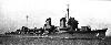
| Japanese destroyer Uranami (1928) FeatureType : landmark Lat/Lng : 11.8333 / 123.0 | Nelson. Japanese-English Character Dictionary. Page 550 was the tenth of twenty-four s, built for the Imperial Japanese Navy following World War I. When introduced into service, these ships were the most powerful destroyers in the world (...) |
| 29 | British Malaya FeatureType : null Lat/Lng : 3.2167 / 101.1 | The term "British Malaya" loosely describes a set of states on the Malay Peninsula and the island of Singapore that were brought under British control between the 18th and the 20th centuries. Unlike the term "British India", which excludes the Indian princely states, British Malaya is often used to (...) | |
| 30 | Kuala Terengganu FeatureType : city Elevation : 12 Lat/Lng : 5.319 / 103.1534 | Kuala Terengganu (Jawi:), often abbreviated as K.T., is a city, the administrative capital, royal capital and the main economic centre of Terengganu, Malaysia. Kuala Terengganu is also the capital of Kuala Terengganu District (...) | |
| 31 | Pahang FeatureType : adm1st Elevation : 111 Lat/Lng : 3.75 / 102.5 | Pahang (; Jawi: ڤهڠ), officially Pahang Darul Makmur with the Arabic honorific Darul Makmur (Jawi: دار المعمور, "The Abode of Tranquility") is a sultanate and a federal state of Malaysia. It is the third largest Malaysian state by area and ninth largest by population (...) | |
| 32 | Johor FeatureType : adm1st Elevation : 23 Lat/Lng : 1.4872 / 103.7811 | Johor , formerly known as Johore, is a state of Malaysia in the south of the Malay Peninsula. Johor has land borders with the Malaysian states of Pahang to the north and Malacca and Negeri Sembilan to the northwest (...) | |
| 33 | Kuantan FeatureType : null Elevation : 17 Lat/Lng : 3.825 / 103.3239 | Kuantan (Chinese: 关丹, Tamil: குவான்டான்) is the state capital of Pahang, Malaysia. It is located near the mouth of the Kuantan River and faces the South China Sea. Kuantan is the 17th largest city in Malaysia based on 2010 population, and the largest city in the East Coast of Peninsular Malaysia (...) | |
| 34 | Miri, Malaysia FeatureType : null Elevation : 8 Lat/Lng : 4.4028 / 113.9933 | Miri (Jawi: ;) is a coastal city in northeastern Sarawak, Malaysia, located near the border of Brunei, on the island of Borneo. The city covers an area of , located northeast of Kuching and southwest of Kota Kinabalu (...) | |
| 35 | Selangor FeatureType : adm1st Elevation : 55 Lat/Lng : 3.3333 / 101.5 | Selangor , also known by its Arabic honorific Darul Ehsan, or "Abode of Sincerity", is one of the 13 states of Malaysia. It is on the west coast of Peninsular Malaysia and is bordered by Perak to the north, Pahang to the east, Negeri Sembilan to the south and the Strait of Malacca to the west (...) | |
| 36 | Sibu FeatureType : city Elevation : 7 Lat/Lng : 2.3203 / 111.8392 | Sibu is an inland town at the central region of Sarawak and the capital of Sibu District in Sibu Division, Sarawak, Malaysia. The town is located on the island of Borneo and covers an area of . It is located at the confluence of the Rajang and Igan Rivers, some 60 kilometres from the South China Sea (...) | |
| 37 | Alor Setar FeatureType : city Elevation : 8 Lat/Lng : 6.1214 / 100.3664 | Alor Setar (Jawi: الور ستار), formerly known as Alor Star from 2004 to 2008, is the state capital of Kedah, Malaysia. It is the second-largest city in the state after Sungai Petani and one of the most-important cities on the west coast of Peninsular Malaysia (...) | |
| 38 | Terengganu FeatureType : adm1st Elevation : 133 Lat/Lng : 4.75 / 103.0 | Terengganu (; Jawi:ترڠڬانو, Terengganu Malay: Tranung, Ganu, Teganu, Ganung, Teganung), formerly spelled Trengganu or Tringganu, is a sultanate and constitutive state of federal Malaysia. The state is also known by its Arabic honorific, Dāru l-Īmān ("Abode of Faith") (...) | |
| 39 | Sarawak FeatureType : adm1st Elevation : 200 Lat/Lng : 3.0381 / 113.7811 | Sarawak is a state of Malaysia. Being the largest among 13 other states with the size almost equal to West Malaysia, Sarawak is located in northwest Borneo Island, and is bordered by the Malaysian state of Sabah to the northeast, Kalimantan (the Indonesian portion of Borneo) to the south, and Brunei (...) | |
| 40 | Penang Island FeatureType : null Elevation : 186 Lat/Lng : 5.3727 / 100.2496 | Penang Island, is the main constituent island of the Malaysian state of Penang. Located at the Malacca Strait, off the northwestern coast of Peninsular Malaysia, it is separated from the mainland by the Penang Strait (...) | |
| 41 | 
| Redang Island FeatureType : isle Elevation : 70 Lat/Lng : 5.7737 / 103.0119 | Redang Island is an island in Kuala Nerus District, Terengganu, Malaysia. It is one of the largest islands off the east coast of Peninsular Malaysia. It is famous for its crystal clear waters and white sandy beaches (...) |
| 42 | Balik Pulau FeatureType : null Elevation : 19 Lat/Lng : 5.35 / 100.2333 | Balik Pulau is a town within the city of George Town in the Malaysian state of Penang. Located at the southwest of Penang Island, it is also the administrative centre of the Southwest Penang Island District. The agricultural town of Balik Pulau was established in 1794 by the British East India (...) | |
| 43 | Balabac, Palawan FeatureType : null Elevation : 92 Lat/Lng : 7.982 / 117.06 | , officially the , is a settlement_text of the Philippines in the province of , . According to the , it has a population of people. Balabac is known of Malaysian brands industry and some people are speaking Malay language. The municipality consists of some 36 islands,http://www.mb.com (...) | |
| 44 | Peninsular Malaysia FeatureType : null Elevation : 311 Lat/Lng : 4.0 / 102.5 | Peninsular Malaysia also known as Malaya or West Malaysia, is the part of Malaysia which lies on the Malay Peninsula and surrounding islands. Its area is , which is nearly 40% of the total area of the country - - or slightly smaller than England and Java island (...) | |
| 45 | El Nido, Palawan FeatureType : city Elevation : 33 Lat/Lng : 11.1956 / 119.4075 | , officially the , is a settlement_text of the Philippines in the province of , . According to the , it has a population of people. It is about south-west of Manila, and about north-east of Puerto Princesa, Palawan’s capital. A managed resource protected area. Accessed 24, 2008 (...) | |
| 46 | Sulu Archipelago FeatureType : isle Lat/Lng : 5.6577 / 120.8273 | The Sulu Archipelago (Tausug: Sūg) is a chain of islands in the Pacific Ocean, in the southwestern Philippines. The archipelago forms the northern limit of the Celebes Sea and southern limit of the Sulu Sea.C.Michael Hogan. 2011 (...) | |
| 47 | Seberang Perai FeatureType : null Elevation : 5 Lat/Lng : 5.394 / 100.3664 | Seberang Perai, also known as Province Wellesley, is a narrow hinterland on the Malay Peninsula opposite Penang Island, which, together with the island, forms the Malaysian state of Penang. It borders Kedah to the north and east, and Perak to the south (...) | |
| 48 | East Malaysia FeatureType : null Elevation : 318 Lat/Lng : 3.0833 / 114.0 | East Malaysia (Malaysia Timur), also known as Sabah, Sarawak and Labuan (Sabah, Sarawak dan Labuan)The latter term is more commonly used in Malaysia to avoid the connotation of "East Malaysia" and "West Malaysia" (Peninsular Malaysia) being two separate countries, as in former East Germany and West (...) | |
| 49 | Air Itam FeatureType : null Elevation : 16 Lat/Lng : 5.4061 / 100.2964 | Air Itam (also spelt as Ayer Itam) is a suburb of George Town in Penang, Malaysia. Nested within the central valleys of Penang Island, it is located approximately southwest of the city centre. Air Itam is one of the well-known places to sample Penang cuisine, and includes a handful of major tourist (...) | |
| 50 | 
| Perhentian Islands FeatureType : isle Elevation : 67 Lat/Lng : 5.91 / 102.73 | The Perhentian Islands (Malay: Kepulauan Perhentian) are islands in Besut District, Terengganu, Malaysia. The two main islands are Perhentian Besar ("Greater Perhentian") and Perhentian Kecil ("Lesser Perhentian") (...) |
| 51 | Pedra Branca, Singapore FeatureType : null Lat/Lng : 1.3304 / 104.4059 | Pedra Branca (formerly referred to by Malaysia as Pulau Batu Puteh and now as Batu Puteh) is an outlying island and also the easternmost point of Singapore. The name means "white rock" in Portuguese , and refers to whitish guano (bird droppings) deposited on the rock (...) | |
| 52 | Bayan Lepas FeatureType : null Elevation : 3 Lat/Lng : 5.2833 / 100.2667 | Bayan Lepas is a town within the city of George Town in the Malaysian state of Penang. It is located within the Southwest Penang Island District, near the southeastern tip of Penang Island. Founded in the 19th century, Bayan Lepas is now home to the Penang International Airport and an eponymous Free (...) | |
| 53 | Straits Settlements FeatureType : country Elevation : 42 Lat/Lng : 1.3667 / 103.8 | The Straits Settlements (نݢري٢ سلت; When writing in Chinese script, modern historians often refer to the Crown colony as 海峽殖民地 or 海峡殖民地 (Hǎixiá zhímíndì) , a literal translation of the Crown colony's English name, rather than the official Chinese name of 叻嶼呷 (Lè yǔ gā) adopted by the Government of (...) | |
| 54 | Jacksons International Airport FeatureType : airport Elevation : 39 Lat/Lng : -9.4433 / 147.22 | Jacksons International Airport , also known as Port Moresby Airport, is located 8 kilometres (5 miles) outside Port Moresby, in Papua New Guinea. It is the largest and busiest airport in Papua New Guinea, with an estimate of 1 (...) | |
| 55 | 
| MacRitchie Reservoir FeatureType : waterbody Elevation : 18 Lat/Lng : 1.3436 / 103.8311 | MacRitchie Reservoir is Singapore's oldest reservoir. The reservoir was completed in 1868 by impounding water from an earth embankment, and was then known as the Impounding Reservoir or Thomson Reservoir. (...) |
| 56 | 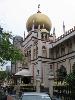
| Masjid Sultan FeatureType : landmark Elevation : 11 Lat/Lng : 1.3022 / 103.859 | Masjid Sultan (Jawi: مسجد سلطان), or Sultan Mosque, is a mosque located at Muscat Street and North Bridge Road within the Kampong Glam precinct of the district of Rochor in Singapore. It was named after Sultan Hussain Shah. In 1975, it was designated a national monument. (...) |
| 57 | SMS Emden FeatureType : null Elevation : 1 Lat/Lng : -11.8333 / 96.8167 | SMS Emden ("His Majesty's Ship Emden") was the second and final member of the of light cruisers built for the Imperial German Navy (Kaiserliche Marine). Named for the town of Emden, she was laid down at the Kaiserliche Werft (Imperial Dockyard) in Danzig in 1906 (...) | |
| 58 | Sultanate of Sulu FeatureType : null Elevation : 2 Lat/Lng : 6.0519 / 121.0019 | The Sultanate of Sulu (Tausūg: Kasultanan sin Sūg, Jawi: کسلطانن سولو دار الإسلام) was a Muslim state that ruled the islands in the Sulu Archipelago, parts of Mindanao, certain portions of Palawan and north-eastern Borneo (present-day the certain parts of Sabah and North Kalimantan) (...) | |
| 59 | Butterworth, Penang FeatureType : city Elevation : 5 Lat/Lng : 5.3942 / 100.3664 | Butterworth, within the North Seberang Perai District, is the largest town in Seberang Perai, the mainland half of the Malaysian state of Penang. It lies approximately east of George Town, the capital city of Penang, across the Penang Strait. , Butterworth contained a total of 71,643 residents (...) | |
| 60 | 
| Sri Mariamman Temple, Singapore FeatureType : landmark Elevation : 14 Lat/Lng : 1.2826 / 103.8453 | The Sri Mariamman Temple (Tamil: ஸ்ரீ மாரியம்மன் கோவில்) is Singapore's oldest Hindu temple. It is an agamic temple, built in the Dravidian style. Located at 244 South Bridge Road, in the downtown Chinatown district, the temple serves the majority Hindu Singaporeans, Tamilians, in the city-state (...) |
| 61 | Singapore River FeatureType : river Elevation : 0 Lat/Lng : 1.2875 / 103.8531 | The Singapore River is a river that runs parallel to Alexandra Road and feeds into the Marina Reservoir in the southern part of Singapore. The immediate upper watershed of the Singapore River is known as the Singapore River Planning Area, although the northernmost part of the watershed is classified (...) | |
| 62 | Sabah State Railway FeatureType : landmark Elevation : 8 Lat/Lng : 5.9589 / 116.0685 | Sabah State Railway (SSR) is a railway system and operator in the state of Sabah in Malaysia. It is the only rail transport system operating on the island of Borneo. The railway consists of a single 134 kilometres line from Tanjung Aru, Kota Kinabalu in West Coast Division to the town of Tenom, in (...) | |
| 63 | Malacca Sultanate FeatureType : landmark Elevation : 20 Lat/Lng : 2.1889 / 102.3844 | The Malacca Sultanate (; Jawi script: كسلطانن ملايو ملاك) was a Malay sultanate centred in the modern-day state of Malacca, Malaysia. Conventional historical thesis marks c. 1400 as the founding year of the sultanate by a Malay Raja of Singapura (King of Singapore), Parameswara, also known as (...) | |
| 64 | Tawau FeatureType : null Elevation : 12 Lat/Lng : 4.2523 / 117.8823 | Tawau (Jawi:) formerly known as Tawao, is the capital of the Tawau District in Sabah, Malaysia. It is the third-largest town in Sabah, after Kota Kinabalu and Sandakan. It is located on the south east coast of the state in the administrative centre of Tawau Division which bordered by the Sulu Sea to (...) | |
| 65 | Komtar FeatureType : null Elevation : 8 Lat/Lng : 5.4145 / 100.3292 | The KOMTAR Tower, in the city of George Town in Penang, Malaysia, is Penang's tallest skyscraper and the sixth tallest building in Malaysia. KOMTAR is an acronym for Kompleks Tun Abdul Razak, named after the second Prime Minister of Malaysia. The tower was constructed in 1974 and completed in 1986 (...) | |
| 66 | 
| CHIJMES FeatureType : landmark Elevation : 16 Lat/Lng : 1.2951 / 103.8518 | CHIJMES (pronounced "chimes", Chinese: 赞美广场, acronym definition: Convent of the Holy Infant Jesus Middle Education School) is a historic building complex in Singapore, which began life as a Catholic convent known as the Convent of the Holy Infant Jesus (CHIJ) (...) |
| 67 | 1998 Commonwealth Games FeatureType : null Elevation : 34 Lat/Lng : 3.1357 / 101.688 | The 1998 Commonwealth Games (Malay: Sukan Komanwel 1998), officially known as the XVI Commonwealth Games (Malay: Sukan Komanwel ke-16), was a multi-sport event held in Kuala Lumpur, Malaysia. This edition is marked by several unprecedented facts in the history of the event (...) | |
| 68 | Bintulu FeatureType : city Elevation : 7 Lat/Lng : 3.1906 / 113.0901 | Bintulu is a coastal town on the island of Borneo in the central region of Sarawak, Malaysia. Bintulu is located 610 kilometres (380 mi) northeast of Kuching, 216 kilometres (134 mi) northeast of Sibu, and 200 kilometres (120 mi) southwest of Miri (...) | |
| 69 | Batu Lintang camp FeatureType : landmark Elevation : 5 Lat/Lng : 1.5308 / 110.3481 | Batu Lintang camp (also known as Lintang Barracks and Kuching POW camp) at Kuching, Sarawak on the island of Borneo was a Japanese internment camp during the Second World War. It was unusual in that it housed both Allied prisoners of war (POWs) and civilian internees (...) | |
| 70 | Rajang River FeatureType : waterbody Lat/Lng : 2.1297 / 111.2192 | The Rajang River is a river in Sarawak, Malaysia. The river is located in northwest of Borneo and it originates in the Iran Mountains. The river flows approximately 563 km into Kapit, and then to the South China Sea, making it the longest river in Malaysia. Encyclopædia Britannica (...) | |
| 71 | PASKAL FeatureType : null Lat/Lng : 2.1483 / 104.455 | The Pasukan Khas Laut (Naval Special Warfare Forces, Jawi: ڤاسوقن خاص لاءوت), commonly abbreviated PASKAL, is the principal special operations force of the Royal Malaysian Navy. PASKAL's task is to conduct small-unit maritime military operations that originate from, and return to a river, ocean, (...) | |
| 72 | Portuguese Malacca FeatureType : null Elevation : 20 Lat/Lng : 2.1889 / 102.3844 | Portuguese Malacca was the territory of Malacca that, for 130 years (1511–1641), was a Portuguese colony. (...) | |
| 73 | Royal Malaysia Police FeatureType : null Elevation : 61 Lat/Lng : 3.1421 / 101.7071 | The Royal Malaysia Police (often abbreviated RMP) , is a (primarily) uniformed federal police force in Malaysia. The force is a centralised organisation. Its headquarters are located at Bukit Aman, Kuala Lumpur (...) | |
| 74 | Singapore Island FeatureType : isle Elevation : 46 Lat/Lng : 1.3539 / 103.7995 | Pulau Ujong (Malay: literally 'island at the end'), also known as Singapore Island or Mainland Singapore, is the main constituent island of Singapore. It is part of the Malay Archipelago and is located at the tip of Peninsular Malaysia (...) | |
| 75 | Brunei Bay FeatureType : waterbody Lat/Lng : 5.0833 / 115.3 | Brunei Bay is on the northwestern coast of Borneo island, in Brunei and Malaysia. Brunei Bay is located 5°00'43.44", 115°17'26.66"; east of Bandar Seri Begawan, Brunei. It is the ocean gateway to the isolated Temburong District of Brunei, separated from the rest of Brunei by the Malaysian Sarawak (...) | |
| 76 | Pulau Tikus FeatureType : null Elevation : 17 Lat/Lng : 5.4315 / 100.3118 | Pulau Tikus is a northwestern suburb of George Town in Penang, Malaysia. Situated between the city centre and Tanjung Tokong, this upper class suburb was named after a rock just off the coast of Penang Island. Pulau Tikus is one of the well-known places to sample Penang cuisine, as well as the home (...) | |
| 77 | Gelugor FeatureType : null Elevation : 15 Lat/Lng : 5.3691 / 100.3097 | Gelugor is a southern suburb of George Town in Penang, Malaysia. Named after a plant species, Gelugor lies along the eastern seaboard of Penang Island, between Jelutong and Sungai Dua, and nearly south of the city centre (...) | |
| 78 | Seberang Perai Municipal Council FeatureType : landmark Elevation : 8 Lat/Lng : 5.371 / 100.433 | The Seberang Perai Municipal Council is the local government which administers Seberang Perai, the mainland half of the Malaysian state of Penang. This agency is under the purview of the Penang state government (...) | |
| 79 | Turtle Islands, Tawi-Tawi FeatureType : city Lat/Lng : 6.0833 / 118.3 | , officially the , is a settlement_text of the Philippines in the province of , . According to the , it has a population of people. It is also known as Philippine Turtle Islands to distinguish it from its Malaysian counterpart. While locals call it Taganak. (...) | |
| 80 | Battle of Labuan FeatureType : event Elevation : 38 Lat/Lng : 5.3203 / 115.2111 | The Battle of Labuan was an engagement fought between Allied and Imperial Japanese forces on the island of Labuan off Borneo during June 1945. It formed part of the Australian invasion of North Borneo, and was initiated by the Allied forces as part of a plan to capture the Brunei Bay area and (...) | |
| 81 | Putra Heights LRT station FeatureType : railwaystation Elevation : 31 Lat/Lng : 2.9961 / 101.5756 | "'Putra Heights'" is a Klang Valley Rapid Transit station in Putra Heights in the southern Subang Jaya. The station are the southern terminus for the Sri Petaling Line and Kelana Jaya Line. The station is located on the intersection of Persiaran Putra Indah and Persiaran Putra Perdana, next to E6 (...) | |
| 82 | Batu Kawan FeatureType : null Elevation : 3 Lat/Lng : 5.2312 / 100.4442 | Batu Kawan is a town within the South Seberang Perai District in Seberang Perai, Penang, Malaysia. It is geographically separated from the rest of Seberang Perai by the Jawi and Tengah rivers. , Batu Kawan contained a population of 5,537 (...) | |
| 83 | Perai FeatureType : null Elevation : 8 Lat/Lng : 5.3775 / 100.3901 | Perai is a town within the Central Seberang Perai District in Seberang Perai, Penang, Malaysia. It lies at the southern bank of the Perai River and borders the town of Butterworth to the north. The town of Perai gave its name to the wider municipality of Seberang Perai, the mainland half of the (...) | |
| 84 | Sultan Abdul Halim Muadzam Shah Bridge FeatureType : landmark Lat/Lng : 5.2615 / 100.3525 | The Sultan Abdul Halim Muadzam Shah Bridge or Penang Second Bridge (or Jambatan Kedua Pulau Pinang; ; or பினாங்கு இரண்டாவது பாலம்) is a dual carriageway toll bridge in Penang, Malaysia. It connects Bandar Cassia (Batu Kawan) in Seberang Perai on mainland Peninsular Malaysia with Batu Maung on Penang (...) | |
| 85 | Kinabalu Park FeatureType : landmark Elevation : 320 Lat/Lng : 6.25 / 116.5 | Kinabalu Park , established as one of the first national parks of Malaysia in 1964, is Malaysia's first World Heritage Site designated by UNESCO in December 2000 for its "outstanding universal values" and the role as one of the most important biological sites in the world with more than 4,500 (...) | |
| 86 | West Kalimantan FeatureType : adm1st Elevation : 33 Lat/Lng : 3.0E-4 / 110.5 | West Kalimantan (Malay: كليمنتان بارت, ; Hakka: Sî-Kâ-lí-màn-tân; Teochew: Sai-Gia-li-man-dang) is a province of Indonesia. It is one of five Indonesian provinces in Kalimantan, the Indonesian part of the island of Borneo. Its capital city is Pontianak (...) | |
| 87 | University of Science, Malaysia FeatureType : landmark Elevation : 20 Lat/Lng : 5.3571 / 100.3014 | ' (acronym: USM) is the only Accelerated Programs for Excellence (APEX) government funded Autonomous university in Malaysia. USM is a full spectrum highest sustainability conceptualized university in the region, striving to achieve "GLOBAL sustainable university status" (...) | |
| 88 | North Borneo FeatureType : waterbody Lat/Lng : 59.9833 / -179.9833 | North Borneo (usually known as British North Borneo, also known as the State of North Borneo) was a British protectorate located in the northern part of the island of Borneo. The territory of North Borneo was originally established by concessions of the Sultanates of Brunei and Sulu in 1877 and 1878 (...) | |
| 89 | Jiajing wokou raids FeatureType : null Elevation : 2 Lat/Lng : 29.7315 / 122.0873 | The Jiajing wokou raids (嘉靖大倭寇 or 嘉靖倭亂) caused extensive damage to the coast of China in the 16th century, during the reign of the Jiajing Emperor (r. 1521–67) in the Ming dynasty. The term "wokou" originally referred to Japanese pirates who crossed the sea and raided Korea and China; however, by (...) | |
| 90 | Sungai Petani FeatureType : null Elevation : 13 Lat/Lng : 5.6459 / 100.4916 | Sungai Petani (abbreviated Sg. Petani or SP; Chinese: 双溪大年; Tamil: சுங்கை பட்டாணி) is a town in Kuala Muda District, Kedah, Malaysia. Sungai Petani is Kedah's largest town and is located about 55 km south of Alor Setar, the capital of Kedah, and 33 km northeast of George Town, the capital city of (...) | |
| 91 | Resorts World Sentosa FeatureType : landmark Elevation : 27 Lat/Lng : 1.2532 / 103.8211 | Resorts World Sentosa (Abbreviation: RWS) is an integrated resort on the island of Sentosa, off the southern coast of Singapore. The key attractions include one of Singapore's two casinos, a Universal Studios theme park, Adventure Cove Water Park, and S.E.A (...) | |
| 92 | Timeline of Malaysia Airlines Flight 370 FeatureType : null Lat/Lng : 14.9 / 109.25 | The timeline of Malaysia Airlines Flight 370 lists events associated with the disappearance of Malaysia Airlines Flight 370—a scheduled, commercial flight operated by Malaysia Airlines from Kuala Lumpur International Airport to Beijing Capital International Airport on 8 March 2014 with 239 (...) | |
| 93 | Copenhagen Suborbitals FeatureType : landmark Elevation : 3 Lat/Lng : 55.6914 / 12.617 | Copenhagen Suborbitals is the world's only manned, amateur, crowd funded space programme. Since its beginning in 2008, Copenhagen Suborbitals has flown five home built rockets and two mock-up space capsules. Their stated goal is to have one of the members fly into space (above 100 km), on a (...) | |
| 94 | Sri Mahamariamman Temple, Penang FeatureType : landmark Elevation : 11 Lat/Lng : 5.4173 / 100.3383 | Built in 1833, the Arulmigu Sri Mahamariamman Temple in George Town is the oldest Hindu temple in Penang, Malaysia, and features sculptures of gods and goddesses over its main entrance and facade. It is located at Queen Street, George Town (...) | |
| 95 | Capture of Malacca (1511) FeatureType : null Elevation : 6 Lat/Lng : 2.2056 / 102.2561 | The Capture of Malacca in 1511 occurred when the governor of Portuguese India Afonso de Albuquerque conquered the city of Malacca in 1511. The port city of Malacca controlled the narrow, strategic Strait of Malacca, through which all seagoing trade between China and India was concentrated (...) | |
| 96 | British Airways Flight 9 FeatureType : event Lat/Lng : -9.2567 / 106.0769 | British Airways Flight 9, sometimes referred to by its callsign Speedbird 9 or as the Jakarta incident, was a scheduled British Airways flight from London Heathrow to Auckland, with stops in Bombay, Madras, Kuala Lumpur, Perth, and Melbourne (...) | |
| 97 | Teluk Intan FeatureType : city Elevation : 5 Lat/Lng : 4.0197 / 101.0249 | Teluk Intan is a town in Hilir Perak District, Perak, Malaysia. It is the district capital and largest town in Hilir Perak district and third largest town in the state of Perak with an estimated population of around 120,000, about half of Hilir Perak district's total population (232,900) (...) | |
| 98 | 2006 Southeast Asian haze FeatureType : null Elevation : 73 Lat/Lng : 3.3547 / 117.5965 | The 2006 Southeast Asian haze event was caused by continued uncontrolled burning from "slash and burn" cultivation in Indonesia, and affected several countries in the Southeast Asian region and beyond, such as Malaysia, Singapore, southern Thailand, and as far as Saipan; the effects of the haze may (...) | |
| 99 | Banggi Island FeatureType : isle Elevation : 46 Lat/Lng : 7.25 / 117.1667 | Banggi Island is located within the Kudat Division of Sabah in Malaysia. With an area of 440.7 square kilometres, it is the largest island in Malaysia followed by Bruit Island, Langkawi Island and Penang Island. It is located off the northern coast of Sabah near Marudu Bay (...) | |
| 100 | Balabac Island FeatureType : isle Elevation : 90 Lat/Lng : 7.9419 / 117.0081 | Balabac Island is the southern-most island of the Palawan province in the Philippines, only about north from Sabah, Malaysia, across the Balabac Strait. Administratively, the island forms the main part of Balabac Municipality and is divided into 14 barangays (the other 6 barangays of the (...) | |
| 101 | Pangkor Island FeatureType : null Elevation : 179 Lat/Lng : 4.2272 / 100.5603 | Pangkor Island is a resort island in Manjung District, Perak, Malaysia. It has a population of approximately 25,000. Nearby islands include Pangkor Laut Island, Giam Island (Pulau Giam), Mentagor Island (Pulau Mentagor), Simpan Island (Pulau Simpan) and Tukun Terindak Island (Pulau Tukun Terindak) (...) | |
| 102 | Palawan (island) FeatureType : null Elevation : 152 Lat/Lng : 9.5 / 118.5 | Palawan is the largest island of the province of Palawan in the Philippines and the fifth largest island of the country. The north west coast of the island is along the South China Sea, while the south east coast forms part of the northern limit of the Sulu Sea.C.Michael Hogan. 2011 (...) | |
| 103 | Sebatik Island FeatureType : isle Elevation : 77 Lat/Lng : 4.1673 / 117.7839 | Sebatik Island (Indonesian/Malay: Pulau Sebatik) is an island off the eastern coast of Borneo, partly within Indonesia and partly within Malaysia. It is one of the 92 officially listed outlying islands of Indonesia. Sebatik has an area of approximately (...) | |
| 104 | Mersing District FeatureType : null Elevation : 38 Lat/Lng : 2.3333 / 103.6667 | The Mersing District is a district in Johor, Malaysia. The district capital is Mersing Town. (...) | |
| 105 | Sipadan FeatureType : isle Elevation : 23 Lat/Lng : 4.1147 / 118.6288 | Sipadan is the only oceanic island in Malaysia, rising from the seabed. It is located in the Celebes Sea off the east coast of Sabah, Malaysia. It was formed by living corals growing on top of an extinct volcanic cone that took thousands of years to develop (...) | |
| 106 | Penang Strait FeatureType : city Lat/Lng : 5.3371 / 100.3505 | The Penang Strait is an 11 kilometre-wide strait that separates Penang Island from mainland Malay Peninsula. Penang Island is to the west of the channel, while Seberang Perai, the mainland half of the State of Penang, is to the east (...) | |
| 107 | Balabac Strait FeatureType : waterbody Lat/Lng : 7.6667 / 117.0 | The Balabac Strait (Filipino: Kipot ng Balabak) is one of the straits that connects the South China Sea with the Sulu Sea. It separates Balabac Island (Palawan province), Philippines, from Balambangan and the Banggi Islands north of Borneo that are a part of Malaysia's Sabah state (...) | |
| 108 | Lingga Islands FeatureType : isle Lat/Lng : -0.267 / 104.483 | Not to be confused with "Linga", a common Scottish island name, see Linga (disambiguation) The Lingga Islands Regency or Lingga Archipelago are a group of islands in Indonesia, located south of Singapore, along both sides of the equator, off the eastern coast of Riau Province on Sumatra island (...) | |
| 109 | Tanjung Tokong FeatureType : null Elevation : 9 Lat/Lng : 5.4476 / 100.3067 | Tanjung Tokong is a suburb of George Town in Penang, Malaysia. It is located along the northeastern coast of Penang Island, next to Pulau Tikus and northwest of the city centre. Over the recent decades, the former fishing village has been transformed into an upper class residential suburb of George (...) | |
| 110 | Swallow Reef FeatureType : null Lat/Lng : 7.3722 / 113.8417 | Swallow Reef, known as Pulau Layang-Layang in Malaysia, 燕子島 in China, Celerio in the Philippines and Đá Hoa Lau in Vietnam, is an oceanic atoll of the Spratly Islands administered by Malaysia, which is situated approximately northwest of Kota Kinabalu, Sabah (...) | |
| 111 | Victoria, Labuan FeatureType : city Elevation : 6 Lat/Lng : 5.2833 / 115.2333 | Victoria or Victoria Town is the capital of the Federal Territory of Labuan in Malaysia, an island group off the north coast of Borneo. It is in the southeast corner of Labuan and its Malay name, "Bandar Labuan" is more commonly used by the locals than Victoria (...) | |
| 112 | Manjung District FeatureType : null Elevation : 6 Lat/Lng : 4.3333 / 100.6667 | The Manjung District is a district in the southwestern part of the state of Perak, Malaysia. The district is well known for its Pangkor Island, a major attraction in Perak and the home of the Royal Malaysian Navy (TLDM) Lumut Naval Base and dockyard (...) | |
| 113 | Teluk Bahang FeatureType : city Elevation : 10 Lat/Lng : 5.4569 / 100.2125 | Teluk Bahang is a town within the city of George Town in the Malaysian state of Penang. It is located within the Southwest Penang Island District, near the northwestern tip of Penang Island. Established as a fishing village, Teluk Bahang has evolved into a tourist destination, with a number of (...) | |
| 114 | Batu Maung FeatureType : null Elevation : 9 Lat/Lng : 5.2847 / 100.2875 | Batu Maung is a residential neighbourhood within the city of George Town in the Malaysian state of Penang. It is located within the Southwest Penang Island District, near the southeastern tip of Penang Island, and adjacent to the town of Bayan Lepas and the Penang International Airport (...) | |
| 115 | South Seberang Perai District FeatureType : null Elevation : 11 Lat/Lng : 5.2333 / 100.4667 | The South Seberang Perai District (abbreviation as “SPS”) is a district in Penang, Malaysia. It covers an area of 242 square kilometres, and had a population of 162,905 at the 2010 Census. The district is bordered by Junjong River that separates Central Seberang Perai in the north, Kedah state (...) | |
| 116 | Mapun FeatureType : null Elevation : 6 Lat/Lng : 6.9767 / 118.5136 | , officially the , is a settlement_text of the Philippines in the province of , . According to the , it has a population of people. It is formerly known as Cagayan de Tawi-Tawi and prior to that as Cagayan de Sulu. Mapun is an island municipality in the Sulu SeaC.Michael Hogan. 2011 (...) | |
| 117 | Semporna FeatureType : null Elevation : 11 Lat/Lng : 4.4791 / 118.6119 | Semporna is the capital of the Semporna District in the Tawau Division of Sabah, Malaysia. Its population was estimated to be around 35,301 in 2010. (...) | |
| 118 | Greater Penang Conurbation FeatureType : null Lat/Lng : 5.205 / 100.35 | The Greater Penang Conurbation that covers all of Penang, southern Kedah and northern Perak is Malaysia's second most populous metropolitan area. It is centred in George Town, Penang's capital city and also the second most populous city in Malaysia after Kuala Lumpur (...) | |
| 119 | Port of Penang FeatureType : null Elevation : 3 Lat/Lng : 5.4157 / 100.366 | The Port of Penang is a deepwater seaport within the Malaysian state of Penang. It consists of terminals along the Penang Strait, including five on the mainland and one in George Town. The Port of Penang was the third busiest harbour in Malaysia in terms of cargo , handling 1 (...) | |
| 120 | Tanjung Bungah FeatureType : null Elevation : 17 Lat/Lng : 5.4651 / 100.2822 | Tanjung Bungah (also spelt as Tanjong Bungah) is a suburb of George Town in Penang, Malaysia. It is located along the northern coast of Penang Island between Batu Ferringhi and Tanjung Tokong, and about northwest of the city centre (...) | |
| 121 | Ambalat FeatureType : null Lat/Lng : 3.7972 / 118.8542 | Ambalat is a sea block in the Celebes sea located off the east coast of Borneo. It lies to the east of the Indonesian province of North Kalimantan and to the south-east of the Malaysian state of Sabah, and it is the subject of a territorial dispute between the two nations (...) | |
| 122 | Central Seberang Perai District FeatureType : null Elevation : 15 Lat/Lng : 5.35 / 100.4667 | The Central Seberang Perai District (SPT;) is a district in the state of Penang, Malaysia. It covers an area of 238 square kilometres, and had a population of 371,975 at the 2010 Census . The district is bordered by Perai River which separates North Seberang Perai in the north, Junjong River which (...) | |
| 123 | Kuala Lumpur railway station FeatureType : railwaystation Elevation : 39 Lat/Lng : 3.1394 / 101.6933 | The Kuala Lumpur railway station is a railway station located in Kuala Lumpur, Malaysia. Completed in 1910 to replace an older station on the same site, the station was Kuala Lumpur's railway hub in the city for the Federated Malay States Railways and its successor Keretapi Tanah Melayu (English: (...) | |
| 124 | Bayan Baru FeatureType : null Elevation : 7 Lat/Lng : 5.3258 / 100.2856 | Bayan Baru is a residential neighbourhood within the city of George Town in the Malaysian state of Penang. It is located within the Southwest Penang Island District, adjacent to the Bayan Lepas Free Industrial Zone. The township was created in the 1970s following the establishment of the zone (...) | |
| 125 | Kek Lok Si FeatureType : landmark Elevation : 95 Lat/Lng : 5.3995 / 100.2737 | The Kek Lok Si Temple is a Buddhist temple situated in Air Itam, Penang, Malaysia, facing the sea, and is one of the best known temples on the island. It is the largest Buddhist temple in Malaysia, and also an important pilgrimage centre for Buddhists from Hong Kong, the Philippines, Singapore and (...) | |
| 126 | Kajang station FeatureType : railwaystation Elevation : 33 Lat/Lng : 2.9828 / 101.7903 | The Kajang railway station is a Malaysian railway station located near and named after the town of Kajang, Selangor. The station is situated 1 km south from Kajang's town centre. (...) | |
| 127 | Penang Botanic Gardens FeatureType : landmark Elevation : 49 Lat/Lng : 5.44 / 100.2883 | The Penang Botanic Gardens, (Malay: Taman Kebun Bunga;Tamil :பினாங்கு தாவரவியல் பூங்கா,Piṉāṅku Tāvaraviyal pūṅkā) also known as the "Waterfall Gardens" because of the cascading waterfall nearby, is a public park situated on Jalan Air Terjun (Waterfall Road) in George Town, Penang, Malaysia (...) | |
| 128 | Penang Hill FeatureType : null Elevation : 735 Lat/Lng : 5.4246 / 100.2689 | Penang Hill is a hill resort comprising a group of peaks on Penang Island, Malaysia. It is located within the Air Itam suburb, west of the centre of George Town. Penang Hill is also known by the Malay name Bukit Bendera, which actually refers to Flagstaff Hill, the most developed peak (...) | |
| 129 | Limbang FeatureType : city Elevation : 8 Lat/Lng : 4.753 / 115.0093 | Limbang is a border town and the capital of Limbang District in the Limbang Division of northern Sarawak, East Malaysia, on the island of Borneo. It is located on the banks of the Limbang River (Sungai Limbang in Malay), between the two halves of Brunei. (...) | |
| 130 | USS Trout (SS-202) FeatureType : null Lat/Lng : 22.6667 / 131.75 | USS Trout (SS-202) was a Tambor-class submarine of the United States Navy, serving in the Pacific from 1941 to 1944. She received 11 battle stars for World War II service and three Presidential Unit Citations, for her second, third, and fifth war patrols (...) | |
| 131 | Klang District FeatureType : null Elevation : 6 Lat/Lng : 3.0833 / 101.4167 | The Klang District is a district in Selangor, Malaysia. It is located in the eastern part of Selangor. It borders the Kuala Selangor District to the north, Petaling to the east, Kuala Langat district to the south and Malacca Straits to the west (...) | |
| 132 | Marine Operations Force FeatureType : null Elevation : 483 Lat/Lng : 5.4 / 100.2333 | The Marine Operations Force (Abbreviation: MOF; ; PGM) is the Marine Police division of the Royal Malaysia Police tasked with maintaining law and order and co-ordinating search and rescue operations in the Malaysian Maritime Zone and on the high seas (...) | |
| 133 | Tawau Division FeatureType : null Elevation : 423 Lat/Lng : 4.5 / 118.0 | Tawau Division is one of the five administrative sub-divisions of Sabah, Malaysia. It occupies a total of 14,905 square kilometres or 20% of Sabah's territory. The main towns include the capital of Tawau, Lahad Datu, Kunak and Semporna (...) | |
| 134 | Japanese cruiser Natori FeatureType : null Lat/Lng : 12.4833 / 128.8167 | was a light cruiser in the Imperial Japanese Navy. The ship was named after the Natori River in Miyagi prefecture, Japan. Natori was the third vessel completed in the Nagara class of light cruisers. Like other vessels of her class, she was intended for use as the flagship of a destroyer flotilla. (...) | |
| 135 | Brooke's Point FeatureType : city Elevation : 7 Lat/Lng : 8.7736 / 117.8383 | , officially the , is a settlement_text of the Philippines in the province of , . According to the , it has a population of people. It is named after Sir James Brooke. This is where the original home of the biggest pearl in the world, known as the Pearl of Lao Tzu or the Pearl of Allah, found in (...) | |
| 136 | Seri Kembangan FeatureType : city Elevation : 57 Lat/Lng : 3.0333 / 101.7167 | Seri Kembangan, formerly known as Serdang New Village, is a town located in Selangor, Malaysia. The town is now a considerable city in size - it is located near the northern end of the PLUS Expressway Southern Route . (...) | |
| 137 | 1976 Sabah Air GAF Nomad crash FeatureType : landmark Elevation : 3 Lat/Lng : 5.9622 / 116.0618 | The Double Six Crash, also known as the Double Six Tragedy, was a crash, involving a GAF N-22B Nomad of Sabah Air, which took place on 6 June 1976 at Kota Kinabalu, Malaysia, killing several local political leaders. (...) | |
| 138 | Malaysia–Thailand border FeatureType : null Lat/Lng : 6.475 / 99.6533 | The Malaysia–Thailand border consists of both a land boundary across the Malay Peninsula and maritime boundaries in the Straits of Malacca and the Gulf of Thailand/South China Sea. Malaysia lies to the south of the border while Thailand lies to the north (...) | |
| 139 | Action of 9 September 1796 FeatureType : event Lat/Lng : 5.6333 / 95.7833 | The Action of 9 September 1796 was an inconclusive minor naval engagement between small French Navy and British Royal Navy squadrons off northeastern Sumatra, near Banda Aceh, during the French Revolutionary Wars (...) | |
| 140 | September 2007 Sumatra earthquakes FeatureType : event Lat/Lng : -4.517 / 101.382 | The September 2007 Sumatra earthquakes were a series of megathrust earthquakes that struck the Sunda Trench off the coast of Sumatra, Indonesia, with three of magnitude 7 or greater. A series of tsunami bulletins was issued for the area. The most powerful of the series had a magnitude of 8 (...) | |
| 141 | Pontian District FeatureType : null Elevation : 5 Lat/Lng : 1.5833 / 103.4167 | The Pontian District is a district in southwest Johor, Malaysia. The name Pontian is also used in the names of two towns in the district, Pontian Besar and Pontian Kechil, of which the latter serves as its district capital (...) | |
| 142 | St. Mary's Cathedral, Sandakan FeatureType : landmark Elevation : 28 Lat/Lng : 5.84 / 118.1115 | The St. Mary's Cathedral also called Cathedral of Sandakan Is the mother church of the Catholic Diocese of Sandakan (Dioecesis Sandakaanus or Keuskupan Sandakan) which is as its name implies in the city Sandakan, Borneo Island in the Asian country of Malaysia (...) | |
| 143 | Battle of Penang FeatureType : null Elevation : 483 Lat/Lng : 5.4 / 100.2333 | The Battle of Penang occurred on 28 October 1914, during World War I. It was a naval action in the Strait of Malacca, in which the German cruiser sank two Allied warships. (...) | |
| 144 | Chan Sow Lin station FeatureType : railwaystation Elevation : 45 Lat/Lng : 3.1278 / 101.7153 | Chan Sow Lin LRT station is an at-grade rapid transit station and interchange station situated in Pudu, Kuala Lumpur, Malaysia. The station serves as an interchange station for the Sri Petaling Line and Ampang Line, formerly known as STAR (...) | |
| 145 | German submarine U-864 FeatureType : landmark Lat/Lng : 60.7695 / 4.6208 | The German submarine U-864 was a Type IXD2 U-boat of Nazi Germany's Kriegsmarine in World War II. She departed from Kiel on 5 December 1944 on her last mission, to transport to Japan a large quantity of mercury and parts and engineering drawings for German jet fighters (...) | |
| 146 | Masjid Jamek LRT station FeatureType : railwaystation Elevation : 37 Lat/Lng : 3.1497 / 101.6964 | Masjid Jamek LRT station is a rapid transit station in Kuala Lumpur, Malaysia. It is the interchange station between two of Rapid KL's light rapid transit (LRT) systems, namely the LRT Ampang and Sri Petaling Lines and the LRT Kelana Jaya Line (...) | |
| 147 | Japanese cruiser Kuma FeatureType : null Lat/Lng : 5.433 / 99.867 | was the lead vessel of the five light cruisers in the Imperial Japanese Navy. page 107 She was named after the Kuma River in Kumamoto prefecture, Japan. (...) | |
| 148 | Wah Yan College, Kowloon FeatureType : null Elevation : 20 Lat/Lng : 22.3146 / 114.1735 | Wah Yan College, Kowloon (WYK; Traditional Chinese: 九龍華仁書院; Jyutping: gau2 lung4 wa4 jan2 syu1 jyun2, demonym: Wahyanite, pl.: Wahyanites) is a Roman Catholic secondary school for boys run by the Chinese Province of the Society of Jesus (...) | |
| 149 | Sungai Buloh station FeatureType : railwaystation Elevation : 37 Lat/Lng : 3.2061 / 101.5803 | The Sungai Buloh railway station is a railway station serving the suburb of Sungai Buloh in Selangor, Malaysia, which is located to the northwest of Kuala Lumpur. It is an interchange station, with one section catering to the KTM Komuter and KTM ETS services, and another section for the MRT Sungai (...) | |
| 150 | Pasar Seni station FeatureType : railwaystation Elevation : 34 Lat/Lng : 3.1425 / 101.6953 | The Pasar Seni station is an integrated rapid transit station in Kuala Lumpur that is served by the Kelana Jaya Line and the Sungai Buloh-Kajang Line. The station is named after the nearby Central Market (known as Pasar Seni or "Art Market" in Malay) and is located near Petaling Street and the area (...) | |
| 151 | Maluri station FeatureType : railwaystation Elevation : 52 Lat/Lng : 3.1233 / 101.727 | The Maluri station is an integrated station for light rapid transit (LRT) and mass rapid transit (MRT) services located on the eastern fringe of Kuala Lumpur near and named after Taman Maluri (Malay; English: Maluri Garden), a residential housing estate (...) | |
| 152 | Roman Catholic Archdiocese of Singapore FeatureType : landmark Elevation : 23 Lat/Lng : 1.296 / 103.8513 | The Archdiocese of Singapore (Latin: Archidioecesis Singaporensis) is an exempt archdiocese of the Latin Church of the Catholic Church. Its territory includes all of Singapore. Its current archbishop is the Most Reverend Monsignor William Goh Seng Chye, D.D., S.T.L. (...) | |
| 153 | National Museum of Singapore FeatureType : landmark Elevation : 32 Lat/Lng : 1.2967 / 103.8486 | The National Museum of Singapore is the oldest museum in Singapore. Its history dates back to 1849, when it was started as a section of a library at Singapore Institution and called the Raffles Library and Museum (...) | |
| 154 | Tanjong Pagar railway station FeatureType : landmark Elevation : 23 Lat/Lng : 1.2728 / 103.8381 | Tanjong Pagar railway station , also called Singapore railway station or Keppel Road railway station, is a former railway station located at 30 Keppel Road in Singapore. The station was the southern terminus of the network operated by Keretapi Tanah Melayu (KTM), the main railway operator in (...) | |
| 155 | Bujang Valley FeatureType : landmark Elevation : 121 Lat/Lng : 5.7373 / 100.4143 | The Bujang Valley is a sprawling historical complex and has an area of approximately 224 km2 situated near Merbok, Kedah, between Gunung Jerai in the north and Muda River in the south, it is the richest archaeological area in Malaysia (...) | |
| 156 | Kudat FeatureType : null Elevation : 14 Lat/Lng : 6.8997 / 116.8502 | Kudat is the capital of the Kudat District in the Kudat Division of Sabah, Malaysia. Its population was estimated to be around 29,025 in 2010. It is located north of Kota Kinabalu, the state capital, and is near the northernmost point of Borneo (...) | |
| 157 | Sekolah Kebangsaan Sungai Binjai FeatureType : edu Elevation : 10 Lat/Lng : 3.1378 / 101.4383 | Sekolah Kebangsaan Sungai Binjai (Jawi:سكوله كبڠسأن سوڠاي بينجاي), commonly known as SK Sungai Binjai or short, SKSB (or sometimes, Binjai), is a primary National School type situated at Batu 6, Pekan Meru, at the city of Klang and the state of Selangor (...) | |
| 158 | Gaya Island FeatureType : null Elevation : 20 Lat/Lng : 6.0181 / 116.0353 | Gaya Island is a sizeable Malaysian island of 1,465 ha, just 10 minutes off Kota Kinabalu, Sabah and forms part of the Tunku Abdul Rahman National Park. Gaya Island derived its name from the Bajau word "Gayo" which means big and occupies an area of 15 km² (3,700 acres) with an elevation of up to 300 (...) | |
| 159 | Taganak Island FeatureType : null Elevation : 96 Lat/Lng : 6.0833 / 118.3167 | Taganak Island is a small tropical island surrounded by the Sulu Sea in the province of Tawi-Tawi, Philippines. The island is the largest of the seven Philippine Turtle Islands. (...) | |
| 160 | Galang Island FeatureType : isle Elevation : 38 Lat/Lng : 0.75 / 104.2333 | Galang (Indonesian: Pulau Galang) is an island of 80 km2 located 25 m (40 km) southeast of Batam, belonging to a group of three islands called Barelang (abbreviation of Batam-Rempang-Galang). Part of the Riau Archipelago, Indonesia, Galang is located just south of Batam and Rempang which themselves (...) | |
| 161 | Ligitan FeatureType : null Lat/Lng : 4.15 / 118.8833 | Ligitan is a small island in Tawau, Sabah, located east of the island of Borneo, in the Celebes Sea. In the past, the island was at the centre of a territorial dispute between Malaysia and Indonesia. The matter was brought for adjudication before the International Court of Justice and, at the end of (...) | |
| 162 | Kapalai FeatureType : null Lat/Lng : 4.2167 / 118.6833 | Kapalai is an island in Tawau Division, Sabah, Malaysia, known for its scuba resorts. The island of Kapalai, just 15 kilometres off Sipadan, was a beautiful island two hundred years ago, but now remains as only a sand bar (...) | |
| 163 | Balambangan Island FeatureType : null Elevation : 51 Lat/Lng : 7.2636 / 116.8892 | Balambangan Island is an island in Kudat Division, Sabah, Malaysia. It is located off the northern tip of Borneo and is situated just about 3 kilometres west of Banggi Island. It is now part of the Tun Mustapha Marine Park. (...) | |
| 164 | Saint John's Island FeatureType : null Elevation : 27 Lat/Lng : 1.2197 / 103.8478 | Saint John's Island, previously known as Pulau Sakijang Bendera, is one of the Southern Islands in Singapore. It is located approximately 6.5 km to the south of the main island of Singapore, off the Straits of Singapore (...) | |
| 165 | Mabul Island FeatureType : null Elevation : 7 Lat/Lng : 4.2457 / 118.6312 | Mabul is a small island off the south-eastern coast of Sabah in Malaysia. The island has been a fishing village since the 1970s. In the 1990s, it first became popular to divers due to its proximity to Sipadan island (...) | |
| 166 | Tunku Abdul Rahman National Park FeatureType : null Lat/Lng : 5.9667 / 116.0 | The Tunku Abdul Rahman National Park comprises a group of 5 islands located between 3 and 8 km off Kota Kinabalu in Sabah, Malaysia. The park is spread over 4,929 hectares, two-thirds of which cover the sea. Before the Ice age, it formed part of the Crocker Range mass of sandstone and sedimentary (...) | |
| 167 | Sungai Nibong FeatureType : null Elevation : 5 Lat/Lng : 5.3425 / 100.3003 | Sungai Nibong is a residential neighbourhood near the eastern coast of Penang Island in Malaysia, about south of the centre of George Town, Penang's capital city. The neighbourhood, within the Northeast Penang Island District, was named after the rivers flowing through the area (...) | |
| 168 | Rempang FeatureType : isle Elevation : 24 Lat/Lng : 0.85 / 104.1667 | Rempang is an island, located 2.5 km South-East of Batam, 165.83 km². belonging to a group of three islands called Barelang (an abbreviation of Batam-Rempang-Galang) A member of the Riau Archipelago, in the Riau Islands province of Indonesia, Rempang is located just south of Batam and north of (...) | |
| 169 | Kuala Nerus District FeatureType : null Elevation : 4 Lat/Lng : 5.3333 / 103.0 | Kuala Nerus is a district in Terengganu, Malaysia. It is the youngest district in the state, having been declared a separate district in 2014. Formerly it was part of Kuala Terengganu district (North Kuala Terengganu) but still governed by Kuala Terengganu City Council (MBKT) which is one of few (...) | |
| 170 | Paya Terubong FeatureType : null Elevation : 145 Lat/Lng : 5.3728 / 100.2797 | Paya Terubong is a suburb of George Town in Penang, Malaysia. Located nearly southwest of the city centre, it is nestled within the central valleys of Penang Island and south of Air Itam. It is also one of the most densely populated areas on Penang Island (...) | |
| 171 | Bukit Pagon FeatureType : mountain Elevation : 1774 Lat/Lng : 4.2963 / 115.3226 | Bukit Pagon is the highest mountain in Brunei. It is situated on the border with Malaysia on the island of Borneo. Bukit Pagon is located in the Temburong District of Brunei. This district is separated from the rest of Brunei by part of the Sarawak State of Malaysia (...) | |
| 172 | Rapid Ferry FeatureType : null Elevation : 5 Lat/Lng : 5.4138 / 100.343 | Rapid Ferry is a shuttle ferry service within the State of Penang, Malaysia, connecting the city of George Town on Penang Island and Butterworth on the mainland. This cross-strait transit has been operational since 1894, making it the oldest ferry service in Malaysia (...) | |
| 173 | Batu Ferringhi FeatureType : null Elevation : 14 Lat/Lng : 5.4683 / 100.242 | Batu Ferringhi is a suburb of George Town in Penang, Malaysia. Located along the northern coast of Penang Island and about northwest of the city centre, it is the prime beach destination in Penang among locals and tourists (...) | |
| 174 | Mount Trusmadi FeatureType : mountain Elevation : 2464 Lat/Lng : 5.55 / 116.5167 | Mount Trusmadi or Trus Madi is second highest mountain in Borneo and Malaysia at . It lies in the state of Sabah, close to Mount Kinabalu, on the island of Borneo. The mountain supports a wide range of unique flora and fauna, including Nepenthes macrophylla, a species of pitcher plant.Marabini, J (...) | |
| 175 | Horsburgh Lighthouse FeatureType : landmark Lat/Lng : 1.3303 / 104.4053 | Horsburgh Lighthouse (Chinese: ;) is an active lighthouse which marks the eastern entrance to the Straits of Singapore. It is situated on Pedra Branca island. Singapore's earliest lighthouse by date of completion, it is located approximately to the east of Singapore and from the Malaysian state of (...) | |
| 176 | George Town – Bayan Lepas LRT line FeatureType : null Elevation : 7 Lat/Lng : 5.4128 / 100.3333 | The George Town – Bayan Lepas line will be the first rapid transit (LRT) line in the Malaysian state of Penang. Conceived by the Penang state government as part of the Penang Transport Master Plan, the proposed line within the city of George Town will link the city centre with the industrial town of (...) | |
| 177 | Macalister Road, George Town FeatureType : null Elevation : 9 Lat/Lng : 5.415 / 100.3267 | Macalister Road is a major thoroughfare in the city of George Town in Penang, Malaysia. The road stretches out of Magazine Circus next to Komtar in the city centre towards the leafier western edge of the city. The road was named after one of the Governors of Penang in the early 19th century (...) | |
| 178 | Esplanade, Penang FeatureType : null Elevation : 7 Lat/Lng : 5.4222 / 100.3419 | The Esplanade is a waterfront location in the heart of George Town, Penang, Malaysia. It covers the field adjacent to Fort Cornwallis, known locally as the Padang, and the seaside promenade along the edge of the field (...) | |
| 179 | LinkBike FeatureType : null Elevation : 8 Lat/Lng : 5.4138 / 100.3284 | LinkBike is a public bicycle sharing system serving the city of George Town in Penang, Malaysia. Launched in 2016, it is the first such system in Malaysia. Currently, there are 250 LinkBike bicycles and 25 stations throughout the city, including its UNESCO World Heritage Site, as well as suburban (...) | |
| 180 | Waterfall Bay, Hong Kong FeatureType : landmark Elevation : 16 Lat/Lng : 22.2526 / 114.133 | Waterfall Bay is a bay in Pok Fu Lam, Hong Kong Island, Hong Kong. Located on the East Lamma Channel off the coast of Wah Fu Estate and Cyberport at Telegraph Bay, it is named after the waterfall that flows into it (...) | |
| 181 | Batu Lanchang FeatureType : null Elevation : 40 Lat/Lng : 5.3833 / 100.3 | Batu Lanchang is a suburb of George Town in Penang, Malaysia. It is located nearly southwest of the city centre, and sandwiched between Air Itam to the west and Jelutong to the east. Formerly an agricultural area, Batu Lanchang has turned into a suburban residential area, with a mix of high-rises (...) | |
| 182 | Kinarut FeatureType : city Elevation : 9 Lat/Lng : 5.82 / 116.05 | Kinarut is a town in the state of Sabah, Malaysia. It is located about 20 kilometres south of the state capital, Kota Kinabalu, and Kinarut railway station is one of the stops on the Sabah State Railway. Kinarut is under the administration of the Papar District. (...) | |
| 183 | Rompin District FeatureType : null Elevation : 27 Lat/Lng : 2.8333 / 103.25 | The Rompin District is a district located in the southeastern corner of Pahang, Malaysia. Rompin is currently belings to Rompin District Council The district covers an area of 5,296 km and located 130 kilometres from Kuantan, the capital city of Pahang (...) | |
| 184 | Saratok FeatureType : null Elevation : 8 Lat/Lng : 1.74 / 111.337 | Saratok is a town, and the capital of the Saratok District (1,586.9 square kilometres) in Betong Division, Sarawak, East Malaysia in the island of Borneo. The last recorded district population was 44,600 (year 2000 census). It is located about 50 kilometers from Betong (...) | |
| 185 | Sarawak Chamber FeatureType : null Elevation : 684 Lat/Lng : 4.0719 / 114.8768 | Sarawak Chamber is the largest known cave chamber in the world by area and the second largest by volume after the Miao Room in China. It is in Gua Nasib Bagus (Good Luck Cave), which is located in Gunung Mulu National Park, in the Malaysian state of Sarawak on the island of Borneo. (...) | |
| 186 | Baram River FeatureType : river Lat/Lng : 4.5883 / 113.9703 | The Baram River is a river in Sarawak on the island of Borneo. The river originates in the Kelabit Highlands, a watershed demarcated by the Iran Mountains of East Kalimantan, which form a natural border with Sarawak. The river flows westwards through tropical rainforest to the South China Sea (...) | |
| 187 | Kuala Langat District FeatureType : null Elevation : 10 Lat/Lng : 2.8333 / 101.5 | The Kuala Langat District is a district of Selangor, Malaysia. It is situated in the southwestern part of Selangor. It covers an area of 858 square kilometres, and had a population of 213,876 at the 2010 Census (exclude foreign) (...) | |
| 188 | 2000 Sipadan kidnappings FeatureType : null Elevation : 23 Lat/Lng : 4.1147 / 118.6288 | The 2000 Sipadan kidnappings was a hostage crisis in Sabah, Malaysia, and the southern Philippines that began with the seizing of twenty-one hostages from the dive resort island of Sipadan at approximately 6:15 p.m. (UTC +8) on 23 April 2000, by up to six Abu Sayyaf (ASG) bandits (...) | |
| 189 | Kowloon Shangri-La FeatureType : landmark Elevation : 13 Lat/Lng : 22.2972 / 114.1774 | Kowloon Shangri-La is a five-star hotel of the Hong Kong-based Shangri-La Hotels and Resorts group. It is located on Mody Road in Tsim Sha Tsui East overlooking Victoria Harbour and the Hong Kong Island skyline. It is the sister hotel to the Island Shangri-La in Admiralty district, Hong Kong. (...) | |
| 190 | St. George's Church, Penang FeatureType : null Elevation : 12 Lat/Lng : 5.4197 / 100.3391 | St. George's Church is a 19th-century Anglican church in the city of George Town in Penang, Malaysia. It is the oldest purpose built Anglican church in Southeast Asia. The church lies within the jurisdiction of the Upper North Archedeaconry of the Anglican Diocese of West Malaysia. (...) | |
| 191 | Kwasa Damansara MRT station FeatureType : railwaystation Elevation : 54 Lat/Lng : 3.1765 / 101.5726 | The Kwasa Damansara station is a mass rapid transit (MRT) station that serves the future township of Kwasa Damansara in Shah Alam, Selangor, Malaysia which is currently being developed. It one of the stations of the MRT Sungai Buloh-Kajang Line and was opened on 16 December 2016 under Phase One (...) | |
| 192 | North Seberang Perai District FeatureType : null Elevation : 6 Lat/Lng : 5.4667 / 100.4333 | The North Seberang Perai District (abbreviation as “SPU”), is an administrative district on the mainland part of Penang State, Malaysia. It covers an area of 267 square kilometres, and had a population of 286,323 at the 2010 Census (...) | |
| 193 | Dato Keramat Road, George Town FeatureType : null Elevation : 8 Lat/Lng : 5.4133 / 100.3262 | Dato Keramat Road is a major thoroughfare in the city of George Town in Penang, Malaysia. It is one of the main roads leading out of the city centre to the western suburbs, stretching from Komtar, in the heart of George Town, towards Air Itam (...) | |
| 194 | Bayan Lepas Free Industrial Zone FeatureType : null Elevation : 1 Lat/Lng : 5.3006 / 100.29 | The Bayan Lepas Free Industrial Zone is a high-tech manufacturing area in Bayan Lepas, near the southeastern tip of Penang Island in Penang, Malaysia. Created in 1972, the area is Malaysia's first free-tade zone and was instrumental in alleviating an economic crisis in Penang (...) | |
| 195 | Farquhar Street, George Town FeatureType : null Elevation : 9 Lat/Lng : 5.4208 / 100.3384 | Farquhar Street is a major thoroughfare in the city of George Town in Penang, Malaysia. Created in the late 18th century, the road forms part of the city centre's civic precinct, and is notable for the colonial buildings built under British rule (...) | |
| 196 | Serangoon Harbour FeatureType : waterbody Lat/Lng : 1.4 / 103.9333 | Serangoon Harbour is a harbour in Singapore located between the mainland island of Singapore (Pulau Ujong) and Pulau Ubin. (...) | |
| 197 | Suffolk House, Penang FeatureType : null Elevation : 18 Lat/Lng : 5.4107 / 100.3055 | In Penang, Malaysia, the Suffolk House (Tamil :சஃப்பால்க் வீடு) refers to two early residences built on the same site located some four miles west of George Town, Penang, on the banks of the Air Itam River (Black Water River in the Malay language) (...) | |
| 198 | Kuah FeatureType : null Elevation : 3 Lat/Lng : 6.32 / 99.85 | Kuah, Kuah Town or Bandar Kuah is a town, mukim and district capital of Langkawi, Kedah, Malaysia. It is the entry point for those coming by ferry from either the mainland or Penang Island. The town is centered on its jetty, which brings in flocks of tourists each year who come to enjoy the shopping (...) | |
| 199 | SPICE Arena FeatureType : landmark Elevation : 22 Lat/Lng : 5.3283 / 100.2808 | The SPICE Arena is an indoor arena located in the township of Bayan Baru in Penang, Malaysia. It serves as Penang's main indoor sports centre as well as the preferred venue within the city-state for meetings, incentives, conferences and exhibitions (MICE) (...) | |
| 200 | Malaysia–Philippines border FeatureType : null Lat/Lng : 3.1828 / 119.4672 | The Malaysia–Philippines border is a maritime boundary located in the South China, Sulu and Celebes Seas. It separates the Malaysian state of Sabah, which is on the island of Borneo, and the Sulu Islands of the southern Philippines (...) | |
 by
by