| 77 records found in wikipedia |
| 1 | 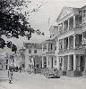
| Suriname 
FeatureType : city
Elevation : 15
Lat/Lng : 5.8681 / -55.1675
| Suriname (also spelled Surinam), officially known as the Republic of Suriname , is a country on the northeastern Atlantic coast of South America. It is bordered by the Atlantic Ocean to the north, French Guiana to the east, Guyana to the west and Brazil to the south (...) |
| 2 | 
| Netherlands Antilles
FeatureType : isle
Elevation : 67
Lat/Lng : 12.1861 / -68.9894
| The Netherlands Antilles (; Papiamentu: Antia Hulandes)Papiamentu/Ingles Dikshonario, Ratzlaff, Betty; p. 11 was a constituent country of the Kingdom of the Netherlands. The country consisted of several island territories located in the Caribbean Sea (...) |
| 3 | 
| Netherlands
FeatureType : country
Elevation : 25
Lat/Lng : 52.35 / 5.7667
| The Netherlands is a country located mainly in Northwestern Europe. Together with three island territories in the Caribbean (Bonaire, Sint Eustatius and Saba), it forms a constituent country of the Kingdom of the Netherlands (...) |
| 4 | | Surinam, Mauritius
FeatureType : null
Elevation : 28
Lat/Lng : -20.5097 / 57.5053
| Surinam is a village located in the Savanne District of Mauritius. According to the Statistics Mauritius census in 2011, the population was 10,507. Nightingale College was a college in Surinam, Mauritius founded on 1 July 1964 by Seewooparsad Goolab (...) |
| 5 | 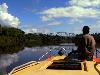
| Commewijne River
FeatureType : null
Elevation : 7
Lat/Lng : 15.4236 / -89.5747
| Commewijne River (Sranan Tongo: Kawina-liba) is a river in northern Suriname (estuary located at around). It originates in the hills of the Commewijne District and flows northwards until it receives the meandering Cottica River from the right and then runs westward until it unites with the (...) |
| 6 | | Wayana
FeatureType : null
Elevation : 78
Lat/Lng : 4.0269 / -54.3325
| The Wayana (alternate names: Ajana, Uaiana, Alucuyana, Guaque, Ojana, Orcocoyana, Pirixi, Urukuena, Waiano etc.) are a Carib-speaking people located in the south-eastern part of the Guiana highlands, a region divided between Brazil, Surinam, and French Guiana (...) |
| 7 | | Surinam Airways Flight 764
FeatureType : landmark
Elevation : 14
Lat/Lng : 5.4533 / -55.2297
| Surinam Airways Flight 764 was an international scheduled passenger flight from Amsterdam Airport Schiphol in the Netherlands to Paramaribo-Zanderij International Airport in Suriname on a Surinam Airways DC-8-62 (...) |
| 8 | 
| Geography of Bermuda
FeatureType : null
Elevation : 6
Lat/Lng : 32.3 / -64.7833
| This article describes the geography of Bermuda. (...) |
| 9 | | Waukegan, Illinois
FeatureType : null
Elevation : 212
Lat/Lng : 42.3725 / -87.8614
| Waukegan is the largest city in and the county seat of Lake County, Illinois, United States. It is a suburb of Chicago, located approximately 35 miles north of The Loop. As of the 2013 census estimate, Waukegan had a population of 88,826, which makes it the ninth-largest city in Illinois by (...) |
| 10 | | Kingdom of the Netherlands
FeatureType : country
Elevation : 61
Lat/Lng : 52.0 / 5.5
| The Kingdom of the Netherlands , commonly known as the Netherlands, is a sovereign state and constitutional monarchy with the large majority of its territory in Western Europe and with several small island territories in the Caribbean Sea, in the West Indies islands (Leeward Islands and Lesser (...) |
| 11 | | Caribbean
FeatureType : waterbody
Lat/Lng : 14.5256 / -75.8183
| The Caribbean is a region of North America that consists of the Caribbean Sea, its islands (some surrounded by the Caribbean Sea and some bordering both the Caribbean Sea and the North Atlantic Ocean) and the surrounding coasts (...) |
| 12 | | Totness, Suriname
FeatureType : city
Elevation : 4
Lat/Lng : 5.8833 / -56.3167
| Totness is a town in Suriname, located in the Coronie district, of which it is the capital. Totness once had a Scottish settlement. The Surinam-Guyana Submarine Cable System has its landing station in Totness. It connects the telecommunications networks in Suriname with those in Guyana and Trinidad (...) |
| 13 | | Moengo
FeatureType : city
Elevation : 9
Lat/Lng : 5.6167 / -54.4
| Moengo is a town in Suriname, located in the Marowijne district, between Paramaribo and the border town Albina. Moengo is also a resort (municipality) in the district of Marowijne. Alcoa's first bauxite mine in Suriname was located in Moengo (...) |
| 14 | | Tsuruga, Fukui
FeatureType : null
Elevation : 7
Lat/Lng : 35.6452 / 136.0555
| is a city located in Fukui Prefecture, Japan. , the city had an estimated population of 66,123 in 28,604 households and the population density of 260 persons per km². The total area of the city was . (...) |
| 15 | | HMS Amelia (1796)
FeatureType : null
Lat/Lng : 44.6833 / -21.4
| Proserpine was a 38-gun Hébé-class frigate of the French Navy launched in 1785 that captured on 13 June 1796. The Admiralty commissioned Proserpine into the Royal Navy as the fifth rate, HMS Amelia. She spent 20 years in the Royal Navy, participating in numerous actions in the French Revolutionary (...) |
| 16 | | Wageningen Airstrip
FeatureType : airport
Elevation : 3
Lat/Lng : 5.8417 / -56.6708
| Wageningen Airstrip is north of Wageningen, in the Nickerie District of Suriname. Heavily used for cropdusting agriculture flights in this rice region of the country. Homebase of the Surinam Sky Farmers (...) |
| 17 | | East India
FeatureType : null
Elevation : 354
Lat/Lng : 23.25 / 86.0
| East India is a region of India consisting of the Indian states of Bihar, Jharkhand, West Bengal, Odisha and also the union territory Andaman and Nicobar Islands. West Bengal's capital Kolkata is the largest city of this region. The Kolkata Metropolitan Area is the country's third largest (...) |
| 18 | | HMS Emerald (1795)
FeatureType : null
Lat/Lng : 13.0333 / -24.0
| HMS Emerald was a 36-gun frigate that Sir William Rule designed in 1794 for the Royal Navy. The Admiralty ordered her construction towards the end of May 1794 and work began the following month at Northfleet dockyard (...) |
| 19 | | Johan Adolf Pengel International Airport
FeatureType : null
Elevation : 13
Lat/Lng : 5.4528 / -55.1878
| Johan Adolf Pengel International Airport , also known as Paramaribo-Zanderij International Airport, and locally referred to simply as JAP, is an airport located in the town of Zanderij and hub for airline carrier Surinam Airways, south of Paramaribo (...) |
| 20 | | Special member state territories and the European Union
FeatureType : null
Elevation : 54
Lat/Lng : 57.9058 / 27.7132
| The special territories of the European Union are 31 territories of EU member states which, for historical, geographical, or political reasons, enjoy special status within or outside the European Union. The special territories divided themselves in two categories: 9 Outermost Regions (OMR) that form (...) |
 by
by