| 370 records found in wikipedia |
| 1 | 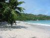
| Seychelles 
FeatureType : country
Elevation : 9
Lat/Lng : -7.0675 / 52.7344
| Seychelles (; French:), officially the Republic of Seychelles (; Creole: Repiblik Sesel), is an archipelago country in the Indian Ocean. The capital of the 115-island country, Victoria, lies east of mainland East Africa (...) |
| 2 | 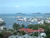
| Mahé, Seychelles
FeatureType : isle
Elevation : 411
Lat/Lng : -4.6667 / 55.4667
| Mahé is the largest island (157.3 km²) of Seychelles, lying in the northeast of the nation in the Indian Ocean. The population of Mahé was 77,000, as of the 2010 census. It contains the capital city of Victoria and accommodates 86% of the country's total population (...) |
| 3 | 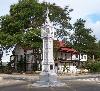
| Victoria, Seychelles
FeatureType : city
Elevation : 6
Lat/Lng : -4.6236 / 55.4544
| Victoria is the capital and largest city of Seychelles, situated on the north-eastern side of Mahé island, the archipelago's main island. The city was first established as the seat of the British colonial government (...) |
| 4 | 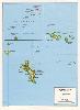
| Geography of Seychelles
FeatureType : null
Elevation : 411
Lat/Lng : -4.6667 / 55.4667
| The Seychelles is a small island nation located in the Indian Ocean northeast of Madagascar and about east of Kenya. Seychelles lies between approximately 4ºS and 10ºS and 46ºE and 54ºE. The nation is an archipelago of 115 tropical islands, some granite and some coral (...) |
| 5 |
| Praslin
FeatureType : isle
Elevation : 186
Lat/Lng : -4.3167 / 55.7333
| Praslin is the second largest island (38.5 km2) of the Seychelles, lying northeast of Mahé. Praslin has a population of around 7,533 people and comprises two administrative districts: Baie Sainte Anne and Grand' Anse. The main settlements are the Baie Ste Anne, Anse Volbert and Grand' Anse (...) |
| 6 | | Granitic Seychelles
FeatureType : null
Lat/Lng : -4.516 / 55.577
| The Granitic Seychelles are the islands in the Seychelles which lie in central position on the Seychelles Bank and are composed of granite rock. They make up the majority of the Inner Islands, which in addition include the coral islands along of the rim of the Seychelles Bank, namely Bird Island and (...) |
| 7 | 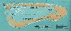
| Aldabra
FeatureType : isle
Lat/Lng : -9.4167 / 46.4167
| Aldabra is the world's second-largest coral atoll. It is situated in the Aldabra Group of islands in the Indian Ocean that are part of the Outer Islands of the Seychelles, with a distance of 1,120 km (700 mi) southwest of the capital, Victoria, on Mahé Island. (...) |
| 8 | | Seychelles International Airport
FeatureType : airport
Elevation : -2
Lat/Lng : -4.6743 / 55.5219
| Seychelles International Airport , or Aéroport de la Pointe Larue in French, is the international airport of the Seychelles located on the island of Mahé near the capital city of Victoria. The airport is the home base and the head office of Air Seychelles" ." Air Seychelles (...) |
| 9 | 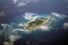
| Amirante Islands
FeatureType : isle
Lat/Lng : -5.9507 / 53.1464
| The Amirante Islands (Les Amirantes) are a group of coral islands and atolls that belong to the Outer Islands of the Seychelles. They stretch about 155 km from the African Banks (African Islands) in the north to Desnœufs (Isle des Noeufs) in the south, all on the shallow Amirantes Bank (Amirantes (...) |
| 10 | 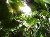
| Vallée de Mai
FeatureType : landmark
Elevation : 211
Lat/Lng : -4.3292 / 55.7375
| Vallée de Mai Nature Reserve ("May Valley") is a nature park and UNESCO World Heritage Site on the island of Praslin, Seychelles. It consists of a well-preserved palm forest, flagship species made up of the island endemic coco de mer, as well as five other endemic palms (...) |
| 11 | 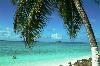
| Diego Garcia
FeatureType : isle
Elevation : 0
Lat/Lng : -7.3133 / 72.4111
| Diego Garcia is an atoll just south of the equator in the central Indian Ocean, and the largest of 60 small islands comprising the Chagos Archipelago. It was settled by the French in the 1790s and was transferred to British rule after the Napoleonic Wars (...) |
| 12 | 
| Mascarene Islands
FeatureType : isle
Lat/Lng : -20.7167 / 56.6167
| The Mascarene Islands or Mascarenes or Mascarenhas Archipelago is a group of islands in the Indian Ocean east of Madagascar consisting of Mauritius, Réunion and Rodrigues. Their name derives from the Portuguese navigator Pedro Mascarenhas, who first visited them in April 1512 (...) |
| 13 | 
| Desroches Island
FeatureType : isle
Elevation : 18
Lat/Lng : -5.6833 / 53.6833
| Desroches Island or Île Desroches is the main island of the Amirante Islands, part of the Outer Islands of the Seychelles. It is located 227 km southwest of Victoria, Seychelles. It is 5.5 km long and has a land area of 4.027 km2. Along its circumference of 13 km is a beach of fine sand (...) |
| 14 | 
| Kumasi
FeatureType : city
Elevation : 257
Lat/Lng : 6.6667 / -1.6167
| Kumasi (historically spelled Comassie or Coomassie and usually spelled Kumase in Twi) is a city in Ashanti Region, and is among the largest metropolitan areas in Ghana. Kumasi is near Lake Bosomtwe, in a rain forest region, and is the commercial, industrial and cultural capital of Asanteman (...) |
| 15 | 
| Réunion
FeatureType : adm1st
Elevation : 1715
Lat/Lng : -21.1144 / 55.5325
| Réunion (; previously Île Bourbon) is an overseas department and region of France and an island in the Indian Ocean, east of Madagascar and southwest of Mauritius. , it had a population of 865,826. It has the highest per capita GDP in the Indian Ocean (...) |
| 16 | 
| Mauritius
FeatureType : country
Elevation : 177
Lat/Lng : -20.2 / 57.5
| Mauritius , officially the Republic of Mauritius , is an island nation in the Indian Ocean about 2,000 kilometres (1,200 mi) off the southeast coast of the African continent. The country includes the islands of Mauritius and Rodrigues, 560 kilometres (350 mi) east of Mauritius, and the outer islands (...) |
| 17 | 
| Indian Ocean
FeatureType : waterbody
Lat/Lng : -20.0 / 80.0
| The Indian Ocean is the third largest of the world's oceanic divisions, covering (approximately 20% of the water on the Earth's surface). It is bounded by Asia on the north, on the west by Africa, on the east by Australia, and on the south by the Southern Ocean or, depending on definition, by (...) |
| 18 | 
| Silhouette Island
FeatureType : isle
Elevation : 562
Lat/Lng : -4.48 / 55.2358
| Silhouette Island lies northwest of Mahé in the Seychelles. It is the third largest granitic island in the Seychelles. It has an area of 20.1 km2 and has a population of 200, mostly workers on the island. The main settlement is La Passe, where Hilton Hotel is located (...) |
| 19 | 
| Glorioso Islands
FeatureType : isle
Elevation : 1
Lat/Lng : -11.5797 / 47.2979
| The Glorieuses or Glorioso Islands (or officially also Archipel des Glorieuses) are a group of French islands and rocks totalling , at , in Comoro Islands, between the french region of Mayotte and Madagascar. In 2012, France founded parc naturel marin des Glorieuses, a marine protected area, to (...) |
| 20 | 
| São Tomé and Príncipe
FeatureType : city
Elevation : 549
Lat/Lng : 0.2336 / 6.6128
| São Tomé and Príncipe , officially the Democratic Republic of São Tomé and Príncipe, is an island country in the Gulf of Guinea, off the western equatorial coast of Central Africa. It consists of two archipelagos around the two main islands of São Tomé and Príncipe, located about apart and about off (...) |
 by
by