| 90 records found in wikipedia |
| 1 | 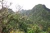
| Rarotonga 
FeatureType : isle
Elevation : 83
Lat/Lng : -21.2538 / -159.7893
| Rarotonga is the most populous island of the Cook Islands, with a population of 10,572 (census 2011), out of the country's total resident population of 14,974. Captain John Dibbs, master of the colonial brig Endeavour, is credited as the European discoverer on 25 July 1823, while transporting the (...) |
| 2 | 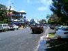
| Avarua
FeatureType : city
Elevation : 11
Lat/Lng : -21.2056 / -159.7806
| Avarua (meaning "Two Harbours" in Cook Islands Māori) is a town and district in the north of the island of Rarotonga, and is the national capital of the Cook Islands. The town is served by Rarotonga International Airport (IATA Airport Code: RAR) and Avatiu Harbour (...) |
| 3 | 
| Cook Islands
FeatureType : country
Elevation : 322
Lat/Lng : -21.2347 / -159.7778
| The Cook Islands (Cook Islands Māori: Kūki 'Āirani) by Jasper Buse & Raututi Taringa, Cook Islands Ministry of Education (1995) page 200 is a self-governing island country in the South Pacific Ocean in free association with New Zealand. It comprises 15 islands whose total land area is (...) |
| 4 | 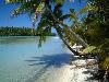
| Aitutaki
FeatureType : isle
Elevation : 40
Lat/Lng : -18.8642 / -159.7858
| Aitutaki, also traditionally known as Araura and Utataki, is one of the Cook Islands, north of Rarotonga. It has a population of approximately 2,000. Aitutaki is the second most visited island of the Cook Islands. The main village is Arutanga (Arutunga) on the west side. (...) |
| 5 | 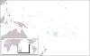
| Niue
FeatureType : country
Elevation : 60
Lat/Lng : -19.0618 / -169.8631
| Niue is an island country in the South Pacific Ocean, northeast of New Zealand, east of Tonga, south of Samoa, and west of the Cook Islands. Niue's land area is about and its population, predominantly Polynesian, was about 1,600 in 2016 (...) |
| 6 | | Rarotonga International Airport
FeatureType : null
Elevation : 7
Lat/Lng : -21.2028 / -159.8056
| Rarotonga International Airport is the Cook Islands' main international gateway, located in the town and district of Avarua, Rarotonga, 3 km west of the downtown area on the northern coast. Because of the close proximity of the runways to the nearby roads, it is possible to get very close to the (...) |
| 7 | 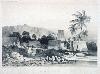
| Fiji
FeatureType : country
Elevation : 175
Lat/Lng : -17.8133 / 179.4122
| Fiji (; ; Fiji Hindi: फ़िजी), officially the Republic of FijiIn February 2011, the Prime Minister's Office issued a statement saying that the name of the state had been officially changed from the Republic of the Fiji Islands to the Republic of Fiji, and that the name written in the 1997 (...) |
| 8 | 
| Penrhyn (atoll)
FeatureType : null
Lat/Lng : -9.0056 / -157.9694
| Penrhyn (also called Tongareva, Mangarongaro, Hararanga, and Te Pitaka) is an island in the northern group of the Cook Islands in the south Pacific Ocean. The northernmost island in the group, it is located at north-north-east of the capital island of Rarotonga, 9 degrees south of the equator (...) |
| 9 | 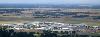
| Christchurch International Airport
FeatureType : airport
Elevation : 33
Lat/Lng : -43.4894 / 172.5322
| Christchurch International Airport is the main airport that serves Christchurch, New Zealand. It is located 12 kilometres to the northwest of the city centre, in the suburb of Harewood. Christchurch (Harewood) Airport officially opened on 18 May 1940 and became New Zealand's first international (...) |
| 10 | 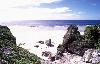
| Atiu
FeatureType : null
Elevation : 42
Lat/Lng : -19.9833 / -158.1167
| Atiu, also known as Enuamanu (meaning land of the birds), is an island 187 km northeast of Rarotonga, in the Southern Islands group of the Cook Islands Archipelago. (...) |
| 11 | 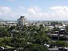
| Daniel K. Inouye International Airport
FeatureType : airport
Elevation : 6
Lat/Lng : 21.3187 / -157.9224
| Daniel K. Inouye International Airport , also known as Honolulu International Airport, is the principal aviation gateway of the City and County of Honolulu on Oahu in the State of Hawaii. It is identified as one of the busiest airports in the United States, with traffic now exceeding 21 million (...) |
| 12 | 
| Suwarrow
FeatureType : isle
Lat/Lng : -13.4181 / -163.1242
| Suwarrow (also called Suvorov, Suvarou, or Suvarov) is an island in the northern group of the Cook Islands in the south Pacific Ocean. It is about south of the equator and north-northwest of the capital island of Rarotonga. (...) |
| 13 | 
| Mangaia
FeatureType : isle
Elevation : 117
Lat/Lng : -21.9214 / -157.9231
| Mangaia (traditionally known as A'ua'u Enua, which means terraced) is the most southerly of the Cook Islands and the second largest, after Rarotonga. (...) |
| 14 | | Manihiki Island Airport
FeatureType : airport
Elevation : 10
Lat/Lng : -10.3806 / -160.9997
| Manihiki Island Airport is a public airport on the atoll of Manihiki in the Cook Islands. At present, the airport is used by a weekly Air Rarotonga flight to Rarotonga. (...) |
| 15 | 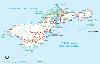
| Pago Pago International Airport
FeatureType : airport
Elevation : 5
Lat/Lng : -14.331 / -170.7105
| Pago Pago International Airport , also known as Tafuna Airport, is a public airport located 7 miles (11.3 km) southwest of the central business district of Pago Pago, in the village and plains of Tafuna on the island of Tutuila in American Samoa, an unincorporated territory of the United States (...) |
| 16 | | Air New Zealand
FeatureType : null
Elevation : 12
Lat/Lng : -36.8449 / 174.7533
| Air New Zealand Limited is the flag carrier airline of New Zealand. Based in Auckland, the airline operates scheduled passenger flights to 20 domestic and 31 international destinations in 19 countries around the Pacific Rim and the United Kingdom (...) |
| 17 | | Polynesia
FeatureType : null
Lat/Lng : -16.853 / 148.4052
| Polynesia (; from polys "many" and nēsos "island"; , , or Poronihia) is a subregion of Oceania, made up of more than 1,000 islands scattered over the central and southern Pacific Ocean. The indigenous people who inhabit the islands of Polynesia are termed Polynesians, and share many similar traits (...) |
| 18 | 
| Nassau (Cook Islands)
FeatureType : isle
Lat/Lng : -11.5678 / -165.4069
| Nassau is an island in the Cook Islands. Located 90 km south of Pukapuka, the small island (0.5 mi²/1.3 km²) of Nassau is just 9 metres (28 feet) above sea level, with an oval sandy cay on a coral reef foundation and is surrounded by a narrow reef flat (...) |
| 19 | 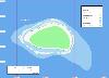
| Takutea
FeatureType : isle
Elevation : 13
Lat/Lng : -19.8131 / -158.2942
| Takutea, in the Cook Islands, is a small uninhabited island northwest of Atiu in the southern Cook Islands. Because it is only in size and has a very dangerous landing at the northwest corner of the reef, it has been designated a wildlife sanctuary, mainly for the red-tailed tropicbirds and (...) |
| 20 | | Palmerston Island
FeatureType : null
Lat/Lng : -18.0583 / -163.1597
| Palmerston Island is a coral atoll in the Cook Islands in the Pacific Ocean about 500 km northwest of Rarotonga. It was discovered by James Cook on 16 June 1774. (...) |
 by
by