| 135 records found in wikipedia |
| 1 | 
| Paramaribo 
FeatureType : city
Elevation : 5
Lat/Lng : 5.8236 / -55.1697
| Paramaribo (nickname: Par′bo) is the capital and largest city of Suriname, located on the banks of the Suriname River in the Paramaribo District. Paramaribo has a population of roughly 241,000 people (2012 census), almost half of Suriname's population (...) |
| 2 | 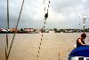
| Suriname River
FeatureType : null
Elevation : 0
Lat/Lng : 5.8181 / -55.1591
| The Suriname River (Dutch: Surinamerivier) is 480 km long and flows through the country Suriname. Its sources are located in the Guiana Highlands on the border between the Wilhelmina Mountains and the Eilerts de Haan Mountains (where it is known as the Gran Rio) (...) |
| 3 | | Paramaribo District
FeatureType : city
Elevation : 5
Lat/Lng : 5.8236 / -55.1697
| Paramaribo is a district of Suriname, encompassing the city of Paramaribo and the surrounding area. Paramaribo district has a population of 240,924, almost half the population of the entire country, and an area of 182 km² (...) |
| 4 | 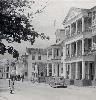
| Suriname
FeatureType : city
Elevation : 15
Lat/Lng : 5.8681 / -55.1675
| Suriname (also spelled Surinam), officially known as the Republic of Suriname , is a country on the northeastern Atlantic coast of South America. It is bordered by the Atlantic Ocean to the north, French Guiana to the east, Guyana to the west and Brazil to the south (...) |
| 5 | 
| Sipaliwini District
FeatureType : adm1st
Elevation : 250
Lat/Lng : 3.7769 / -56.0278
| Sipaliwini is the largest district of Suriname, located in the south. Sipaliwini does not have a regional capital as it is directly administered by the national government in Paramaribo. The main villages in the district are Apetina, Apoera, Bakhuys, Bitagron, Pokigron, Kajana, Kamp 52, Pelelu Tepu, (...) |
| 6 | 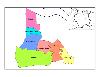
| Wanica District
FeatureType : adm1st
Elevation : 4
Lat/Lng : 5.7967 / -55.2639
| Wanica is a district of Suriname, in the northeast. Wanica's capital city is Lelydorp. Wanica has a population of 118,222 and an area of 443 km². Following neighbouring Paramaribo, Wanica is the second most populated and urbanised district of Suriname (...) |
| 7 | 
| Georgetown, Guyana
FeatureType : null
Elevation : 3
Lat/Lng : 6.8011 / -58.1553
| Georgetown is a city and the capital of Guyana, located in Region 4, which is also known as the Demerara-Mahaica region. It is the country's largest urban centre. It is situated on the Atlantic Ocean coast at the mouth of the Demerara River and it was nicknamed 'Garden City of the Caribbean (...) |
| 8 | 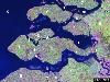
| Zeeland
FeatureType : null
Elevation : 2
Lat/Lng : 51.49 / 3.81
| Zeeland (; , Zeelandic: Zeêland , historical English exonym Zealand) is the westernmost and least populous province of the Netherlands. The province, located in the south-west of the country, consists of a number of islands and peninsulas (hence its name, meaning "Sealand") and a strip bordering (...) |
| 9 | 
| Lelydorp
FeatureType : null
Elevation : 12
Lat/Lng : 5.7017 / -55.2333
| Lelydorp is the capital city of Wanica District, located in Suriname. With a population of 18,663 (2012), it is the second largest city in Suriname, after Paramaribo. It is located at around . It was originally called Kofi Djompo but was renamed by Cornelis Lely (the Dutch governor of Suriname in (...) |
| 10 | 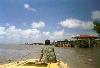
| Nieuw Amsterdam, Suriname
FeatureType : city
Elevation : 1
Lat/Lng : 5.8808 / -55.0844
| Nieuw Amsterdam (or) is the capital of the Commewijne District in Suriname. It is a small coastal town situated at the confluence of the Suriname River and Commewijne River, just across from Paramaribo, the country's capital (...) |
| 11 | 
| Groningen, Suriname
FeatureType : city
Elevation : 20
Lat/Lng : 5.7833 / -55.4667
| Groningen is the capital town of the Saramacca District, Suriname. Groningen only began to grow after 1960. Around that time the East-West Link, a road linking Albina via Paramaribo to Nieuw Nickerie was built. This let Groningen become accessible by road (...) |
| 12 | | 's Lands Hospitaal
FeatureType : null
Elevation : 11
Lat/Lng : 5.8306 / -55.1564
| 's Lands Hospitaal is a hospital in Paramaribo, Suriname. (...) |
| 13 | | Zorg en Hoop Airport
FeatureType : airport
Elevation : 1
Lat/Lng : 5.8111 / -55.1903
| Zorg en Hoop Airport is an airport serving general aviation in the city of Paramaribo, Suriname. It is west of the Suriname River, between the city quarters of Zorg en Hoop and Flora. The runway length includes a displaced threshold on Runway 11 (...) |
| 14 | 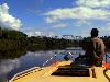
| Commewijne River
FeatureType : null
Elevation : 7
Lat/Lng : 15.4236 / -89.5747
| Commewijne River (Sranan Tongo: Kawina-liba) is a river in northern Suriname (estuary located at around). It originates in the hills of the Commewijne District and flows northwards until it receives the meandering Cottica River from the right and then runs westward until it unites with the (...) |
| 15 | | Meerzorg
FeatureType : null
Elevation : 6
Lat/Lng : 5.8 / -55.15
| Meerzorg is a town in Suriname, located on the eastern bank of the Suriname River, directly opposite the capital Paramaribo. Its population at the 2012 census was 12,405. Since 2000 it has been connected to Paramaribo by the Jules Wijdenbosch Bridge, named after the former President Jules (...) |
| 16 | | Welgelegen, Paramaribo District
FeatureType : null
Elevation : 3
Lat/Lng : 5.84 / -55.2203
| Welgelegen is a resort in Suriname, located in the Paramaribo District. Its population at the 2012 census was 19,304. (...) |
| 17 | | Centrum, Paramaribo
FeatureType : null
Elevation : 10
Lat/Lng : 5.5083 / -55.1789
| Centrum is a resort in Suriname, located in the Paramaribo District. Its population at the 2012 census was 20,631. (...) |
| 18 | 
| André Kamperveen Stadion
FeatureType : null
Elevation : 3
Lat/Lng : 5.8374 / -55.1608
| André Kamperveen Stadium formerly the National Stadion is a multi-purpose stadium in Paramaribo, Suriname. Since its opening in 1953, the stadium has been the official home stadium of both football teams S.V. Transvaal and S.V (...) |
| 19 | | Zanderij
FeatureType : null
Elevation : 17
Lat/Lng : 5.4559 / -55.211
| Zanderij is a village located in the northern part of Suriname, situated 50 kilometres south of the capital Paramaribo on the Southern East-West Link. The Johan Adolf Pengel International Airport is located near the village. |
| 20 | | Fort Zeelandia (Paramaribo)
FeatureType : landmark
Elevation : 7
Lat/Lng : 5.8252 / -55.1499
| Fort Zeelandia is a fortress in Paramaribo, Suriname, that was built in 1640 French as a wooden structurehttp://www.suriname.nu/302ges/archi198.html The British took the fort and called it Fort Willoughby. In 1651 a small trading post was created by the Dutch (...) |
 by
by