| 295 records found in wikipedia |
| 1 | 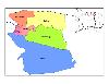
| Commewijne District 
FeatureType : adm1st
Elevation : 25
Lat/Lng : 5.8697 / -54.9197
| Commewijne is a district of Suriname, located on the right bank of the Suriname River. Commewijne's capital city is Nieuw Amsterdam. Tamanredjo is another major town. The district has a population of 31,420 and an area of 2,353 km² (...) |
| 2 | 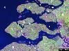
| Zeeland
FeatureType : null
Elevation : 2
Lat/Lng : 51.49 / 3.81
| Zeeland (; , Zeelandic: Zeêland , historical English exonym Zealand) is the westernmost and least populous province of the Netherlands. The province, located in the south-west of the country, consists of a number of islands and peninsulas (hence its name, meaning "Sealand") and a strip bordering (...) |
| 3 | 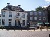
| Nieuw-Amsterdam, Netherlands
FeatureType : null
Elevation : 15
Lat/Lng : 52.715 / 6.8625
| Nieuw-Amsterdam (or) is a village in the northeast Netherlands, in the Dutch province of Drenthe. It borders the village of Veenoord, the twin village of Nieuw-Amsterdam. Since 1998 Nieuw-Amsterdam and Veenoord are part of the municipality of Emmen. (...) |
| 4 | 
| Enkhuizen
FeatureType : city
Elevation : 2
Lat/Lng : 52.7036 / 5.29
| Enkhuizen is a municipality and a city in the Netherlands, in the province of North Holland and the region of West-Frisia. (...) |
| 5 | 
| Den Helder
FeatureType : null
Elevation : 3
Lat/Lng : 52.9583 / 4.7589
| Den Helder is a municipality and a city in the Netherlands, in the province of North Holland. Den Helder occupies the northernmost point of the North Holland peninsula. It is home to the country's main naval base (...) |
| 6 | 
| Hoofddorp
FeatureType : null
Elevation : -3
Lat/Lng : 52.3056 / 4.6925
| Hoofddorp (; literally translated as Main Village) is the main town of the Haarlemmermeer municipality in the province of North Holland in the Netherlands. In 2009, the population was just over 73,000. The town was founded in 1853, immediately after the Haarlemmermeer had been drained (...) |
| 7 | 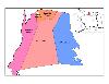
| Nickerie District
FeatureType : adm1st
Elevation : 5
Lat/Lng : 5.7672 / -56.8703
| Nickerie is a district of Suriname, on the north-west coast. Nickerie's capital city is Nieuw-Nickerie, the second largest city in the country. Other towns include Washabo and Wageningen. The district borders the Atlantic Ocean to the north, the Surinamese district of Coronie to the east, the (...) |
| 8 | 
| Amersfoort
FeatureType : null
Elevation : 6
Lat/Lng : 52.1525 / 5.3869
| Amersfoort is a city and municipality in the province of Utrecht, Netherlands. In August 2017, the municipality had a population of 155,089, making it the second-largest of the province and fifteenth-largest of the country (...) |
| 9 | 
| Puncak Jaya
FeatureType : mountain
Elevation : 4746
Lat/Lng : -4.0789 / 137.1595
| Puncak Jaya or Carstensz Pyramid (4,884 m) is the highest summit of Mount Jayawijaya or Mount Carstensz in the Sudirman Range of the western central highlands of Papua Province, Indonesia (within Puncak Jaya Regency) (...) |
| 10 | 
| Middelburg
FeatureType : null
Elevation : 0
Lat/Lng : 51.4944 / 3.6056
| Middelburg is a city and municipality in the south-western Netherlands serving as the capital of the province of Zeeland. Situated on the central peninsula of the Zeeland province, Midden-Zeeland (consisting of former islands Walcheren, Noord-Beveland and Zuid-Beveland), it has a population of about (...) |
| 11 | 
| Katwijk
FeatureType : null
Elevation : 8
Lat/Lng : 52.2008 / 4.4153
| Katwijk is a coastal municipality and town in the province of South Holland, which is situated in the mid-western part of the Netherlands. The Oude Rijn ("Old Rhine") river flows through the town and into the North Sea (...) |
| 12 | 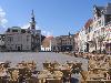
| Bergen op Zoom
FeatureType : city
Elevation : 14
Lat/Lng : 51.4944 / 4.2867
| Bergen op Zoom (;Zoom in isolation: . called Berrege in the local dialect) is a municipality and a city located in the south of the Netherlands. (...) |
| 13 | 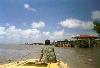
| Nieuw Amsterdam, Suriname
FeatureType : city
Elevation : 1
Lat/Lng : 5.8808 / -55.0844
| Nieuw Amsterdam (or) is the capital of the Commewijne District in Suriname. It is a small coastal town situated at the confluence of the Suriname River and Commewijne River, just across from Paramaribo, the country's capital (...) |
| 14 | 
| Hoogeveen
FeatureType : city
Elevation : 10
Lat/Lng : 52.7167 / 6.4667
| Hoogeveen (Dutch Low Saxon: 't Ogeveine or 't Oveine) is a municipality and a town in the northeastern Netherlands. (...) |
| 15 | 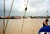
| Suriname River
FeatureType : null
Elevation : 0
Lat/Lng : 5.8181 / -55.1591
| The Suriname River (Dutch: Surinamerivier) is 480 km long and flows through the country Suriname. Its sources are located in the Guiana Highlands on the border between the Wilhelmina Mountains and the Eilerts de Haan Mountains (where it is known as the Gran Rio) (...) |
| 16 | 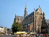
| Haarlem
FeatureType : null
Elevation : 5
Lat/Lng : 52.3803 / 4.6406
| Haarlem (; predecessor of Harlem in the English language) is a city and municipality in the Netherlands. It is the capital of the province of North Holland and is situated at the northern edge of the Randstad, one of the most populated metropolitan areas in Europe. Haarlem had a population of in (...) |
| 17 | 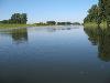
| Maaseik
FeatureType : city
Elevation : 30
Lat/Lng : 51.1019 / 5.7856
| Maaseik (Limburgs: Mezeik) is a town and municipality in the Belgian province of Limburg. Both in size (close to 77 km²) as in population (around 25,000 inhabitants, of whom ca. 3,000 non-Belgian), it is the 8th largest municipality in Limburg (...) |
| 18 | 
| Apeldoorn
FeatureType : null
Elevation : 16
Lat/Lng : 52.2094 / 5.9683
| Apeldoorn is a municipality and city in the province of Gelderland in the centre of the Netherlands. It is a regional centre. The municipality of Apeldoorn, including villages like Beekbergen, Loenen, Ugchelen and Hoenderloo, had a population of in (...) |
| 19 | 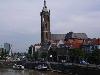
| Roermond
FeatureType : null
Elevation : 29
Lat/Lng : 51.1925 / 5.9936
| Roermond is a city, a municipality, and a diocese in the southeastern part of the Netherlands. Roermond is an historically important town, on the lower Roer at the east bank of the Meuse river. It received town rights in 1231. Roermond town centre has been designated as a conservation area (...) |
| 20 | 
| Utrecht
FeatureType : null
Elevation : 9
Lat/Lng : 52.0889 / 5.1156
| Utrecht is the fourth-largest city and a municipality of the Netherlands, capital and most populous city of the province of Utrecht. It is located in the eastern corner of the Randstad conurbation and had a population of in (...) |
 by
by