| 91 records found in wikipedia |
| 1 | 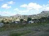
| Maseru 
FeatureType : city
Elevation : 1570
Lat/Lng : -29.3156 / 27.502
| Maseru is the capital and largest city of Lesotho. It is also the capital of the Maseru District. Located on the Caledon River, Maseru lies directly on the Lesotho-South Africa border. Maseru is Lesotho's capital city with a population of 330,760 in the 2016 census (...) |
| 2 | 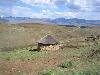
| Lesotho
FeatureType : country
Elevation : 2302
Lat/Lng : -29.6 / 28.3
| Lesotho officially the Kingdom of Lesotho is an enclaved country within the border of South Africa. It is just over in size and has a population of around million. Its capital and largest city is Maseru. Lesotho was previously known as Basutoland, but it declared independence from the United Kingdom (...) |
| 3 | | Maseru District
FeatureType : adm1st
Elevation : 2186
Lat/Lng : -29.5833 / 27.8333
| Maseru is a district of Lesotho. Maseru is also the name of the district's capital, and is the only city in the district and also the capital of the country. It is the largest urban area in the country, and therefore the only city (...) |
| 4 | 
| Mafeteng
FeatureType : city
Elevation : 1674
Lat/Lng : -29.8222 / 27.2383
| Mafeteng is a city in Lesotho, and the Camptown (capital city) of the district of Mafeteng. It is located about 76 kilometres south of the country's capital, Maseru and has a population of approximately 61,000. The South African border town to Mafeteng is Wepener (...) |
| 5 | 
| Ceuta
FeatureType : adm2nd
Elevation : 14
Lat/Lng : 35.8883 / -5.3156
| Ceuta (or). Oxford Dictionaries. is an Spanish autonomous city on the north coast of Africa, separated by from Cadiz province on the Spanish mainland by the Strait of Gibraltar and sharing a land border with M'diq-Fnideq Prefecture in the Kingdom of Morocco (...) |
| 6 | 
| Bloemfontein
FeatureType : null
Elevation : 1382
Lat/Lng : -29.1198 / 26.2248
| Bloemfontein (;Dictionary Reference: The Free Dictionary: ; Afrikaans and Dutch "fountain of flowers" or "blooming fountain"; also known as Bloem) is the capital city of the province of Free State of South Africa; and, as the judicial capital of the nation, one of South Africa's three national (...) |
| 7 | 
| Austin, Texas
FeatureType : null
Elevation : 139
Lat/Lng : 30.2672 / -97.7639
| Austin is the capital of the U.S. state of Texas and the seat of Travis County, with portions extending into Hays and Williamson counties. It is the 11th-most populous city in the United States and the 4th-most populous city in Texas (...) |
| 8 | 
| Roma, Lesotho
FeatureType : city
Elevation : 1665
Lat/Lng : -29.4467 / 27.7081
| Roma is a settlement under the Manonyane Community Council in the Maseru District of Lesotho, some 34 kilometers southeast of Maseru, the capital of Lesotho. The Roma valley is broad and fertile, and is surrounded by sandstone cliffs topped to the East by basalt mountains which provide magnificent (...) |
| 9 | | Moshoeshoe I International Airport
FeatureType : null
Elevation : 1625
Lat/Lng : -29.4623 / 27.5525
| Moshoeshoe I International Airport is an airport serving Maseru, the capital city of Lesotho. The airport is named in honor of Moshoeshoe I, king of Lesotho in the 1850s. It is in the town of Mazenod, southeast of downtown Maseru. Runway length includes a displaced threshold on Runway 04 (...) |
| 10 | | Free State (province)
FeatureType : adm1st
Elevation : 1381
Lat/Lng : -28.0 / 27.0
| The Free State (; ; ; ; ; before 1995, the Orange Free State) is a province of South Africa. Its capital is Bloemfontein, which is also South Africa's judicial capital. Its historical origins lie in the Boer republic called Orange Free State and later Orange Free State Province. (...) |
| 11 | | Semonkong Airport
FeatureType : null
Elevation : 2224
Lat/Lng : -29.8386 / 28.06
| Semonkong Airport is an airport serving the village of Semonkong in Maseru District, Lesotho. (...) |
| 12 | | Berea District
FeatureType : adm1st
Elevation : 1743
Lat/Lng : -29.1667 / 27.9167
| Berea is a district of Lesotho. In the west, Berea borders on the Free State Province of South Africa. Domestically, it borders on the following districts: Leribe District in the north, Thaba-Tseka District in southeast and Maseru District in the south. Teyateyaneng is the capital of the district (...) |
| 13 | | Caledon River
FeatureType : null
Elevation : 1434
Lat/Lng : -29.4775 / 26.0725
| The Caledon River is a major river located in central South Africa, rising in the Drakensberg Mountains on the Lesotho border, flowing southwestward and then westward before joining the Orange River near Bethulie in the southern Free State. (...) |
| 14 | | Roman Catholic Archdiocese of Maseru
FeatureType : null
Elevation : 1562
Lat/Lng : -29.317 / 27.4949
| The Roman Catholic Archdiocese of Maseru is the metropolitan see for the ecclesiastical province of Maseru in Lesotho. (...) |
| 15 | | Basutoland
FeatureType : null
Elevation : 2189
Lat/Lng : -29.5167 / 27.8
| Basutoland was a British Crown colony established in 1884 due to the Cape Colony's inability to control the territory. It was divided into seven administrative districts: Berea, Leribe, Maseru, Mohale's Hoek, Mafeteng, Qacha's Nek and Quthing (...) |
| 16 | | Drakensberg
FeatureType : landmark
Elevation : 2997
Lat/Lng : -29.359 / 29.4689
| The Drakensberg (Afrikaans: Drakensberge, Zulu: uKhahlamba, Sotho: Maluti) is the name given to the eastern portion of the Great Escarpment, which encloses the central Southern African plateau. The Great Escarpment reaches its greatest elevation in this region – (...) |
| 17 | | Maseru Central
FeatureType : null
Elevation : 1559
Lat/Lng : -29.3064 / 27.475
| Maseru Central is a constituency and community council in the Maseru Municipality located in the Maseru District of Lesotho. The population in 2006 was 37,529.Lesotho Bureau of Statistics, 2006. (...) |
| 18 | | Abia Community
FeatureType : null
Elevation : 1604
Lat/Lng : -29.3827 / 27.5377
| Abia is a constituency and community council in the Maseru Municipality located in the Maseru District of Lesotho. The population in 2006 was 17,449.Lesotho Bureau of Statistics, 2006. (...) |
| 19 | | Makhalaneng
FeatureType : null
Elevation : 1818
Lat/Lng : -29.6167 / 27.7667
| Makhalaneng is a community council located in the Maseru District of Lesotho. The population in 2006 was 13,146.Lesotho Bureau of Statistics, 2006, (...) |
| 20 | | Ladybrand
FeatureType : null
Elevation : 1588
Lat/Lng : -29.1941 / 27.4572
| Ladybrand is a small agricultural town in the Free State province of South Africa, situated 18 km from Maseru, the capital of Lesotho. Ladybrand is one of five towns that forms the Mantsopa Local Municipality. Retrieved 2010-09-11 (...) |
 by
by