| 44375 records found in wikipedia |
| 1 | 
| London, Ontario 
FeatureType : city
Elevation : 262
Lat/Lng : 42.9837 / -81.2497
| London is a city in Southwestern Ontario, Canada along the Quebec City–Windsor Corridor. The city has a population of 383,822 according to the 2016 Canadian census. London is at the confluence of the Thames River, approximately from both Toronto, Ontario and Detroit, Michigan; and about from (...) |
| 2 | 
| London
FeatureType : city
Elevation : 8
Lat/Lng : 51.5094 / -0.1183
| London is the capital and largest city of both the United Kingdom and England. Standing on the River Thames in southeastern England, upstream from its estuary with the North Sea, London has been a major settlement for two millennia. Londinium was founded by the Romans (...) |
| 3 | 
| East London, Eastern Cape
FeatureType : null
Elevation : 60
Lat/Lng : -33.0146 / 27.9036
| East London is a city on the southeast coast of South Africa in the Buffalo City Metropolitan Municipality of the Eastern Cape province. The city lies on the Indian Ocean coast, largely between the Buffalo River and the Nahoon River, and hosts the country's only river port (...) |
| 4 | 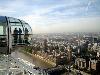
| London Eye
FeatureType : landmark
Elevation : 3
Lat/Lng : 51.5033 / -0.1199
| The London Eye is a giant Ferris wheel on the South Bank of the River Thames in London. It is Europe's tallest Ferris wheel, is the most popular paid tourist attraction in the United Kingdom with over 3.75 million visitors annually, and has made many appearances in popular culture (...) |
| 5 | 
| London Borough of Hammersmith and Fulham
FeatureType : adm1st
Elevation : 10
Lat/Lng : 51.4929 / -0.2258
| The London Borough of Hammersmith and Fulham (pronunciation) is a London borough partly in West London (Hammersmith, West Kensington) and partly in South West London (Fulham), and forms part of Inner London. Traversed by the east-west main roads of the A4 Great West Road and the A40 Westway, many (...) |
| 6 | 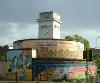
| London Borough of Lambeth
FeatureType : adm1st
Elevation : 7
Lat/Lng : 51.4891 / -0.1107
| Lambeth . Collins Dictionary. is a London borough in south London, England, which forms part of Inner London. Its name was recorded in 1062 as Lambehitha ("landing place for lambs") and in 1255 as Lambeth. The geographical centre of London is at Frazier Street near Lambeth North tube station, though (...) |
| 7 | 
| London Bridge
FeatureType : landmark
Elevation : 3
Lat/Lng : 51.5081 / -0.0878
| Several bridges named London Bridge have spanned the River Thames between the City of London and Southwark, in central London. The current crossing, which opened to traffic in 1973, is a box girder bridge built from concrete and steel (...) |
| 8 | 
| London Borough of Islington
FeatureType : adm1st
Elevation : 23
Lat/Lng : 51.5333 / -0.1333
| The London Borough of Islington is a London borough in Inner London, England. The borough includes a significant area to the south which forms part of central London. Islington has an estimated population of 215,667 (...) |
| 9 | 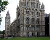
| Natural History Museum, London
FeatureType : landmark
Elevation : 18
Lat/Lng : 51.496 / -0.1764
| The Natural History Museum in London is a natural history museum that exhibits a vast range of specimens from various segments of natural history. It is one of three major museums on Exhibition Road in South Kensington, the others being the Science Museum and the Victoria and Albert Museum (...) |
| 10 | 
| New London, Connecticut
FeatureType : null
Elevation : 27
Lat/Lng : 41.3556 / -72.1008
| New London is a seaport city and a port of entry on the northeast coast of the United States, located at the mouth of the Thames River in New London County, Connecticut. It was one of the world's three busiest whaling ports for several decades beginning in the early 19th century, along with (...) |
| 11 | 
| London Borough of Richmond upon Thames
FeatureType : adm1st
Elevation : 13
Lat/Lng : 51.4613 / -0.3035
| The London Borough of Richmond upon Thames (pronunciation) in southwest London, England, forms part of Outer London and is the only London borough on both sides of the River Thames. It was created in 1965 when three smaller council areas amalgamated under the London Government Act 1963 (...) |
| 12 | 
| London Borough of Hackney
FeatureType : adm3rd
Elevation : 21
Lat/Lng : 51.5333 / -0.0833
| The London Borough of Hackney is a London Borough in Inner London, United Kingdom. The historical and administrative heart of Hackney is Mare Street, which lies north-east of Charing Cross. The borough is named after Hackney, its principal district (...) |
| 13 | 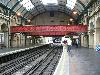
| London Paddington station
FeatureType : landmark
Elevation : 31
Lat/Lng : 51.5163 / -0.1776
| Paddington, also known as London Paddington, is a Central London railway terminus and London Underground station complex, located on Praed Street in the Paddington area. The site has been the London terminus of services provided by the Great Western Railway and its successors since 1838 (...) |
| 14 | 
| London Borough of Newham
FeatureType : adm1st
Elevation : 6
Lat/Lng : 51.5255 / 0.0352
| The London Borough of Newham is a London borough formed from the former Essex county boroughs of West Ham and East Ham, within east London, the name being a portmanteau word reflecting its creation while combining the compass points of the old borough names (...) |
| 15 | 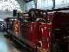
| London Transport Museum
FeatureType : landmark
Elevation : 29
Lat/Lng : 51.5119 / -0.1217
| The London Transport Museum, or LT Museum based in Covent Garden, London, seeks to conserve and explain the transport heritage of Britain's capital city. The majority of the museum's exhibits originated in the collection of London Transport, but, since the creation of Transport for London (TfL) in (...) |
| 16 | 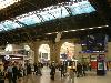
| London Victoria station
FeatureType : landmark
Elevation : 18
Lat/Lng : 51.4966 / -0.1448
| Victoria station, also known as London Victoria, is a central London railway terminus and connected London Underground station in Victoria, in the City of Westminster, managed by Network Rail. The main line station is a terminus of the Brighton main line to and and the Chatham main line to and Dover (...) |
| 17 | 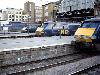
| London King's Cross railway station
FeatureType : landmark
Elevation : 21
Lat/Lng : 51.5306 / -0.1232
| King's Cross railway station, also known as London King's Cross, is a Central London railway terminus on the northern edge of the city. It is one of the busiest railway stations in the United Kingdom and the southern terminus of the East Coast Main Line to North East England and Scotland (...) |
| 18 | 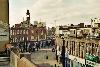
| London Borough of Lewisham
FeatureType : adm1st
Elevation : 35
Lat/Lng : 51.4167 / -0.0333
| The London Borough of Lewisham is a London borough in south London, England and forms part of Inner London. The principal settlement of the borough is Lewisham. The local authority is Lewisham London Borough Council and it is based in Catford. The Prime Meridian passes through Lewisham (...) |
| 19 | 
| London Borough of Croydon
FeatureType : adm1st
Elevation : 153
Lat/Lng : 51.3333 / -0.0833
| The London Borough of Croydon (pronunciation) is a London borough in south London, England and is part of Outer London. It covers an area of and is the largest London borough by population. It is the southernmost borough of London (...) |
| 20 | 
| Strand, London
FeatureType : landmark
Elevation : 28
Lat/Lng : 51.5114 / -0.119
| Strand (or the Strand) is a major thoroughfare in the City of Westminster, Central London. It runs just over from Trafalgar Square eastwards to Temple Bar, where the road becomes Fleet Street inside the City of London, and is part of the A4, a main road running west from inner London (...) |
 by
by