| 255 records found in wikipedia |
| 1 | 
| Isar 
FeatureType : waterbody
Elevation : 1762
Lat/Lng : 47.3546 / 11.4817
| The Isar is a river in Tyrol, Austria and Bavaria, Germany. Its source is in the Karwendel range of the Alps in Tyrol; it enters Germany near Mittenwald, and flows through Bad Tölz, Munich, and Landshut before reaching the Danube near Deggendorf (...) |
| 2 | 
| Auer Mühlbach
FeatureType : waterbody
Elevation : 528
Lat/Lng : 48.0919 / 11.5487
| Auer Mühlbach is a river in Bavaria, Germany. It is a branch of the Isar in the southern part of Munich. (...) |
| 3 | 
| Rechts der Isar Hospital
FeatureType : landmark
Elevation : 525
Lat/Lng : 48.136 / 11.599
| The Rechts der Isar Hospital (translation: Right-hand side of the River Isar) is a hospital in the Haidhausen district of Munich, Germany. (...) |
| 4 | 
| Landshut
FeatureType : null
Elevation : 395
Lat/Lng : 48.5394 / 12.1508
| Landshut is a town in Bavaria in the south-east of Germany. Situated on the banks of the River Isar, Landshut is the capital of Lower Bavaria, one of the seven administrative regions of the Free State of Bavaria (...) |
| 5 | | Isar, Province of Burgos
FeatureType : city
Elevation : 845
Lat/Lng : 42.3622 / -3.9293
| Isar is a municipality located in the province of Burgos, Castile and León, Spain. |
| 6 | 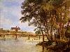
| Prater Island
FeatureType : isle
Elevation : 510
Lat/Lng : 48.1362 / 11.5905
| Prater Island (Praterinsel) is one of the two islands in the Isar in Munich. The other is Museum Island. |
| 7 | 
| Würm
FeatureType : river
Elevation : 532
Lat/Lng : 48.1439 / 11.4542
| The Würm is a river in Bavaria, Germany, right tributary of the Amper. The length of the river is , or including the Steinbach, the main feed of Lake Starnberg. It drains the overflow from Lake Starnberg and flows swiftly through the villages of Gauting, Krailling, Planegg, Gräfelfing and Lochham as (...) |
| 8 | 
| Deutsches Museum
FeatureType : landmark
Elevation : 522
Lat/Lng : 48.1301 / 11.5838
| The Deutsches Museum (German Museum) in Munich, Germany, is the world's largest museum of science and technology, with about 28,000 exhibited objects from 50 fields of science and technology. It receives about 1.5 million visitors per year (...) |
| 9 | 
| Thalkirchen-Obersendling-Forstenried-Fürstenried-Solln
FeatureType : city
Elevation : 560
Lat/Lng : 48.089 / 11.519
| Thalkirchen-Obersendling-Forstenried-Fürstenried-Solln is the 19th borough of Munich, Germany, comprising the extreme southern part of the city on the west bank of the river Isar. After the administrative reform, the boroughs Thalkirchen-Obersendling-Forstenried and Solln were incorporated, thus (...) |
| 10 | | Wörth an der Isar
FeatureType : null
Elevation : 369
Lat/Lng : 48.6244 / 12.3328
| Wörth an der Isar is a municipality in the district of Landshut in Bavaria in Germany. (...) |
| 11 | | Landau an der Isar
FeatureType : null
Elevation : 376
Lat/Lng : 48.6691 / 12.6939
| ] Landau an der Isar (official name: Landau a.d.Isar) is the second largest town in the Lower Bavarian district, or Landkreis, of Dingolfing-Landau, in the state of Bavaria, Germany. It lies on the river Isar. In 2005, the population was around 12,950. (...) |
| 12 | 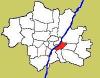
| Au-Haidhausen
FeatureType : city
Elevation : 523
Lat/Lng : 48.1319 / 11.5889
| Au-Haidhausen is the 5th borough of the German city of Munich, Bavaria. It is formed by the Au and Haidhausen districts. (...) |
| 13 | 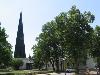
| Untergiesing-Harlaching
FeatureType : city
Elevation : 552
Lat/Lng : 48.0922 / 11.5606
| Untergiesing-Harlaching is the 18th borough of Munich, Germany, mostly the districts of Untergiesing and Harlaching. The borough's western border is the river Isar, in the south it borders on Grünwald and the Perlacher Forst (Perlach Forest), to the north-west on the Munich borough of Obergiesing (...) |
| 14 | | Loisach
FeatureType : null
Elevation : 566
Lat/Lng : 47.9364 / 11.4339
| The Loisach is a river that flows through Tyrol, Austria and Bavaria, Germany. Its name is Celtic in origin, from Proto-Celtic *lawo and *iskā, both of which mean "water." The Loisach is a 113 km long left tributary to the Isar. The source of the Loisach is near Ehrwald in Austria (...) |
| 15 | 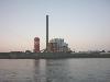
| E.ON
FeatureType : landmark
Elevation : 40
Lat/Lng : 51.2333 / 6.7728
| E.ON SE (marketed with an interpunct and lowercase letters as e·on) is a European holding company based in Essen, North Rhine-Westphalia, Germany. It runs one of the world's largest investor-owned electric utility service providers. The name comes from the Greek word aeon which means age (...) |
| 16 | 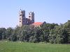
| St. Maximilian, Munich
FeatureType : landmark
Elevation : 521
Lat/Lng : 48.1268 / 11.5737
| St. Maximilian is a Roman Catholic parish church of the Isar suburb in Munich, southern Germany. It was built from 1892 to 1908 under design by in the Romanesque Revival style. St. Maximilian is located on the banks of the Isar, facing the tower of the Deutsches Museum. (...) |
| 17 | | Amper
FeatureType : landmark
Elevation : 409
Lat/Lng : 48.5003 / 11.9567
| The Amper, called the Ammer upstream of the Ammersee, through which it runs, is the largest tributary of the Isar in southern Bavaria, Germany. It flows generally north-eastward, reaching the Isar in Moosburg, about from its source in the Ammergau Alps, with a flow of 45 m³/s (...) |
| 18 | 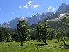
| Karwendel
FeatureType : mountain
Elevation : 2649
Lat/Lng : 47.4114 / 11.4375
| The Karwendel is the largest mountain range of the Northern Limestone Alps. The major part belongs to the Austrian federal state of Tyrol, while the adjacent area in the north is part of Bavaria, Germany. Four chains stretch from west to east; in addition, there are a number of fringe ranges and an (...) |
| 19 | 
| Munich
FeatureType : null
Elevation : 525
Lat/Lng : 48.1397 / 11.5744
| Munich is the capital and most populous city of the second most populous German federal state of Bavaria, and, with a population of around 1.5 million, it is the third-largest city of Germany after Berlin and Hamburg, as well as the 12th-largest city in the European Union (...) |
| 20 | 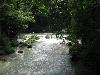
| Eisbach (Isar)
FeatureType : waterbody
Elevation : 506
Lat/Lng : 48.1619 / 11.6094
| The Eisbach (German for "ice brook") is a small, two kilometer long, manmade river in Munich. It flows through the park known as the Englischer Garten, and is a side arm of the Isar River. A manmade wave has been created on one section (...) |
 by
by