| 180 records found in wikipedia |
| 1 | | Caledon, Ontario 
FeatureType : null
Elevation : 402
Lat/Lng : 43.8501 / -79.9997
| Caledon (2016 population 66,502) is a town in the Regional Municipality of Peel in the Greater Toronto Area of Ontario, Canada. Caledon is a developing urban area although it remains primarily rural. It consists of an amalgamation of a number of urban areas, villages, and hamlets; its major urban (...) |
| 2 | 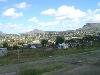
| Maseru
FeatureType : city
Elevation : 1570
Lat/Lng : -29.3156 / 27.502
| Maseru is the capital and largest city of Lesotho. It is also the capital of the Maseru District. Located on the Caledon River, Maseru lies directly on the Lesotho-South Africa border. Maseru is Lesotho's capital city with a population of 330,760 in the 2016 census (...) |
| 3 | | Caledon River
FeatureType : null
Elevation : 1434
Lat/Lng : -29.4775 / 26.0725
| The Caledon River is a major river located in central South Africa, rising in the Drakensberg Mountains on the Lesotho border, flowing southwestward and then westward before joining the Orange River near Bethulie in the southern Free State. (...) |
| 4 | | Caledon, Western Cape
FeatureType : city
Elevation : 257
Lat/Lng : -34.23 / 19.4283
| Caledon is a town in the Overberg region in the Western Cape province of South Africa, located about east of Cape Town next to mineral-rich hot springs. it had a population of 13,020. It is located in, and the seat of, the Theewaterskloof Local Municipality (...) |
| 5 | 
| Robben Island
FeatureType : isle
Elevation : 13
Lat/Lng : -33.8067 / 18.3662
| Robben Island is an island in Table Bay, west of the coast of Bloubergstrand, Cape Town, South Africa. The name is Dutch for "seal island." Robben Island is roughly oval in shape, long north-south, and wide, with an area of (...) |
| 6 | | Caledon Lake
FeatureType : waterbody
Elevation : 441
Lat/Lng : 43.8805 / -80.106
| Caledon Lake is a lake wholly within Caledon, Peel Region, Ontario, Canada. Caledon Lake is in the heart of the Greater Toronto Area Greenbelt. (...) |
| 7 | 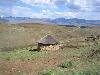
| Lesotho
FeatureType : country
Elevation : 2302
Lat/Lng : -29.6 / 28.3
| Lesotho officially the Kingdom of Lesotho is an enclaved country within the border of South Africa. It is just over in size and has a population of around million. Its capital and largest city is Maseru. Lesotho was previously known as Basutoland, but it declared independence from the United Kingdom (...) |
| 8 | 
| Burntisland
FeatureType : null
Elevation : 14
Lat/Lng : 56.0625 / -3.2322
| Burntisland (listen) is a royal burgh and parish in Fife, Scotland, on the northern shore of the Firth of Forth. According to the 2011 census, the town has a population of 6,269. It is known locally for its award-winning sandy beach, the 15th-century Rossend Castle, as well as the traditional summer (...) |
| 9 | 
| George, Western Cape
FeatureType : null
Elevation : 224
Lat/Lng : -33.9647 / 22.4714
| George is a city in the Western Cape province of South Africa. The city is a popular holiday and conference centre and the administrative, commercial hub and the capital city of the Garden Route. The city is situated halfway between Cape Town and Port Elizabeth on the Garden Route (...) |
| 10 | 
| Kugluktuk
FeatureType : city
Lat/Lng : 67.8256 / -115.095
| Kugluktuk (Inuinnaqtun: Qurluktuk, "the place of moving water"; Inuktitut: ᖁᕐᓗᖅᑐᖅ , formerly Coppermine until 1 January 1996) is a hamlet located at the mouth of the Coppermine River in the Kitikmeot Region of Nunavut, Canada, on Coronation Gulf, southwest of Victoria Island (...) |
| 11 | 
| Rankin Inlet
FeatureType : city
Lat/Lng : 62.8167 / -92.0833
| Rankin Inlet (; Inuktitut syllabics: ᑲᖏᕿᓂᖅ or Kangirliniq, ᑲᖏᖅᖠᓂᖅ, or Kangir&iniq meaning deep bay/inlet) is an Inuit hamlet on Kudlulik Peninsula in Nunavut, Canada. at the Atlas of Canada Located on the northwestern Hudson Bay, between Chesterfield Inlet and Arviat, it is the regional centre for (...) |
| 12 | 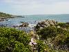
| Hermanus
FeatureType : null
Elevation : 25
Lat/Lng : -34.4192 / 19.24
| Hermanus (originally called Hermanuspietersfontein, but shortened in 1902 as the name was too long for the postal service at the official), is a town on the southern coast of the Western Cape province of South Africa (...) |
| 13 | | Overberg District Municipality
FeatureType : adm2nd
Elevation : 73
Lat/Lng : -34.4964 / 20.0665
| The Overberg District Municipality is a district municipality that governs the Overberg region in the Western Cape province of South Africa. It is divided into four local municipalities and includes the major towns of Grabouw, Caledon, Hermanus, Bredasdorp and Swellendam (...) |
| 14 | | Caledon, County Tyrone
FeatureType : null
Elevation : 33
Lat/Lng : 54.35 / -6.833
| Caledon) is a small village and townland (of 232 acres) in County Tyrone, Northern Ireland. It is in the Clogher Valley on the banks of the River Blackwater, 7 miles from Armagh. It lies in the southeast of Tyrone and near the borders of County Armagh and County Monaghan (...) |
| 15 | | Regional Municipality of Peel
FeatureType : null
Elevation : 245
Lat/Lng : 43.751 / -79.778
| The Regional Municipality of Peel (also known as the Region of Peel or Peel Region) is a regional municipality in Southern Ontario, Canada. It consists of three municipalities to the west and northwest of Toronto: the cities of Brampton and Mississauga, and the town of Caledon (...) |
| 16 | 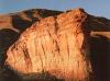
| Golden Gate Highlands National Park
FeatureType : null
Elevation : 2104
Lat/Lng : -28.5244 / 28.6208
| Golden Gate Highlands National Park is located in Free State, South Africa, near the Lesotho border. It covers an area of . The park's most notable features are its golden, ochre, and orange-hued, deeply eroded sandstone cliffs and outcrops, especially the Brandwag rock (...) |
| 17 | | Orange River
FeatureType : river
Lat/Lng : -28.6333 / 16.45
| The Orange River (from Afrikaans/Dutch: Oranjerivier) is the longest river in South Africa and the Orange River Basin extends extensively into Namibia and Botswana to the north. It rises in the Drakensberg mountains in Lesotho, flowing westwards through South Africa to the Atlantic Ocean (...) |
| 18 | | Brampton
FeatureType : city
Elevation : 216
Lat/Lng : 43.6773 / -79.7374
| Brampton (or) is a city in the Canadian province of Ontario. Situated in Southern Ontario, it is a suburban city in the Greater Toronto Area (GTA) and the seat of Peel Region. The city has a population of 593,638 as of the Canada 2016 Census (...) |
| 19 | | Dufferin County
FeatureType : null
Elevation : 496
Lat/Lng : 44.0834 / -80.2497
| Dufferin County is a county and census division located in Central Ontario, Canada. The county seat is Orangeville, and the current Warden is Paul Mills. The current chief administrative officer is Sonya Pritchard . Dufferin covers an area of , and its population is 61,735 (2016). (...) |
| 20 | | Bolton, Ontario
FeatureType : null
Elevation : 221
Lat/Lng : 43.8795 / -79.7379
| Bolton (2011 population 25,954) is the most populous community in the town of Caledon, located in the Region of Peel, approximately 50 kilometres northwest of Toronto, in Ontario, Canada. In regional documents, it is referred to as a 'Rural Service Centre (...) |
 by
by