| 58 records found in wikipedia |
| 1 | 
| Chiavenna 
FeatureType : city
Elevation : 319
Lat/Lng : 46.3167 / 9.4
| Chiavenna (Latin and or Claven, archaic or Kleven) is a comune (municipality) in the Province of Sondrio in the Italian region of Lombardy. It is the centre of the Alpine Valchiavenna region. The historic town is a member of the Cittaslow movement. (...) |
| 2 | | Bregaglia Range
FeatureType : mountain
Elevation : 2931
Lat/Lng : 46.295 / 9.705
| The Bregaglia Range (commonly the Bregaglia) is a small group of mostly granite mountains in Graubünden, Switzerland and the Province of Sondrio, northern Italy. It derives its name from the partly Swiss, partly Italian valley, the Val Bregaglia, and is known as Bergell in German (...) |
| 3 | 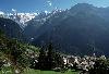
| Piz Badile
FeatureType : mountain
Elevation : 3261
Lat/Lng : 46.2953 / 9.5865
| Piz Badile (3,308 m) is a mountain of the Bregaglia range in the Swiss canton of Graubünden and the Italian region of Lombardy, the border between the two countries running along the summit ridge. Its north-east face, overlooking the Swiss Val Bregaglia near Soglio, is considered one of the six (...) |
| 4 | 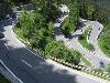
| Maloja Pass
FeatureType : pass
Elevation : 1819
Lat/Lng : 46.4017 / 9.6954
| Maloja Pass (Italian: Passo del Maloja, German: Malojapass) (1815m a.s.l.) is a high mountain pass in the Swiss Alps in the canton of Graubünden, linking the Engadine with the Val Bregaglia, still in Switzerland and Chiavenna in Italy. It marks the divide between the Danube and Po watersheds (...) |
| 5 | 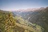
| Engadin
FeatureType : landmark
Elevation : 1700
Lat/Lng : 46.5497 / 9.8959
| The Engadin or Engadine (; lit.: Valley of the Inn people) is a long high Alpine valley region in the eastern Swiss Alps located in the canton of Graubünden in most southeastern Switzerland with about 25,000 inhabitants (...) |
| 6 | | Bregaglia
FeatureType : null
Elevation : 1004
Lat/Lng : 46.3434 / 9.5906
| Bregaglia is a municipality in the Maloja Region in the canton of Grisons in Switzerland. It was formed by the 2010 merger of the municipalities of Bondo, Castasegna, Soglio, Stampa and Vicosoprano, all located in the Val Bregaglia. (...) |
| 7 | 
| Albigna lake
FeatureType : waterbody
Elevation : 2084
Lat/Lng : 46.33 / 9.6475
| Albigna Lake (German: Albignasee, Italian: Lago da l'Albigna, Romansh: Lägh da l'Albigna) is a reservoir in the canton of Graubünden, Switzerland. It is located in the municipality of Vicosoprano at an elevation of 2,163 m on the southwest side of the Bregaglia valley, northeast of Pizzo Cacciabella (...) |
| 8 | | Val Bregaglia
FeatureType : null
Elevation : 694
Lat/Lng : 46.3326 / 9.5174
| The Val Bregaglia is an alpine valley of Switzerland and Italy at the base of which runs the river Mera (in Switzerland). The valley begins at the Maloja Pass (1815 m) which connects it to the Engadin (the valley of the Inn, which is part of the Danube basin) and extends westwards to Chiavenna (...) |
| 9 | | Casaccia, Graubünden
FeatureType : landmark
Elevation : 1464
Lat/Lng : 46.3911 / 9.6664
| Casaccia is a village located in the Val Bregaglia, in the Swiss canton of Graubünden. It lies at an altitude of 1,458 metres above sea level, at the southern foot of Piz Lunghin. The village belongs to the municipality of Bregaglia. (...) |
| 10 | | Mera (river, Switzerland)
FeatureType : waterbody
Elevation : 2857
Lat/Lng : 46.3944 / 9.5728
| The Mera (also called in Switzerland) is a river in Switzerland and Italy. Its source is near the Piz Mungiroi, in the Grisons, Switzerland. First, it flows east in the direction to Maloja Pass, then turns west through the Val Bregaglia and crosses the border to Italy in Castasegna (...) |
| 11 | 
| Septimer Pass
FeatureType : pass
Elevation : 2311
Lat/Lng : 46.4187 / 9.6369
| Septimer Pass (German: Septimerpass, Italian: Passo del Settimo, Romansh: Pass da Sett) (el. 2310 m.) is a high mountain pass in the canton of Graubünden in the Swiss Alps between the valleys of Bregaglia (Bergell) and Oberhalbstein (Surses). During the Middle Ages, this, the Great St (...) |
| 12 | | Bernina Range
FeatureType : mountain
Elevation : 3778
Lat/Lng : 46.3839 / 9.9092
| The Bernina Range is a mountain range in the Alps of eastern Switzerland and northern Italy. It is considered to be part of the Rhaetian Alps within the Central Eastern Alps. It is one of the highest ranges of the Alps, covered with many glaciers (...) |
| 13 | 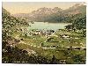
| Lake Sils
FeatureType : waterbody
Elevation : 1795
Lat/Lng : 46.4193 / 9.7331
| Lake Sils (German Silsersee, Romansh: Lej da Segl) is a lake in the Upper Engadine valley, Grisons, Switzerland. It takes its name from the village of Sils im Engadin. The lake lies at an altitude of 1,797 metres above sea level, between Maloja Pass and Lake Silvaplana (...) |
| 14 | | Piz Duan
FeatureType : mountain
Elevation : 3084
Lat/Lng : 46.376 / 9.5835
| Piz Duan is a mountain of the Oberhalbstein Range, overlooking Vicosoprano and the Val Bregaglia, in the Swiss canton of Graubünden. (...) |
| 15 | | Cima di Castello
FeatureType : mountain
Elevation : 3299
Lat/Lng : 46.3029 / 9.6767
| Cima di Castello is a mountain of the Bregaglia Range, located on the border between Italy and Switzerland. With a height of above sea level, it is the second highest mountain in the Bregaglia Range. Its summit lies between the valleys of the Albigna and Forno Glacier (both in the Swiss canton of (...) |
| 16 | | Cima dal Cantun
FeatureType : mountain
Elevation : 3286
Lat/Lng : 46.3107 / 9.6784
| Cima dal Cantun is a mountain of the Bregaglia Range (Alps), located between the valleys of the Albigna and the Forno Glacier in Graubünden. (...) |
| 17 | | Monte Disgrazia
FeatureType : mountain
Elevation : 3582
Lat/Lng : 46.2694 / 9.7495
| Monte Disgrazia (3,678 m) is a mountain in the Bregaglia range in the Italian Alps. It is the highest peak in the Val Masino group, situated south of the Bernina Range. It has five glaciers and five wild ridges and is a demanding climb. The first ascent was by Leslie Stephen, E. S (...) |
| 18 | 
| Piz Lunghin
FeatureType : mountain
Elevation : 2720
Lat/Lng : 46.4105 / 9.6703
| Piz Lunghin (2,780 m) is a mountain in the Swiss canton of Graubünden, located in the Albula range, overlooking the Maloja Pass. It can be considered as the "roof of Europe" as the pass is nearby the triple watershed of the Lunghin pass (...) |
| 19 | | Cima di Rosso
FeatureType : mountain
Elevation : 3310
Lat/Lng : 46.3065 / 9.7184
| The Cima di Rosso is a mountain in the Bregaglia Range of the Alps, located on the border between Italy and Switzerland. It lies between the valleys of Bregaglia (in Graubünden) and Malenco (in Lombardy). On the western side of the mountain is the Forno Glacier. (...) |
| 20 | | Oberhalbstein Alps
FeatureType : mountain
Elevation : 2450
Lat/Lng : 46.5231 / 9.5108
| The Oberhalbstein Alps or Platta Group are a mountain range in the Alps of eastern Switzerland and northern Italy. They are considered to be part of the Central Eastern Alps. The Oberhalbstein Alps are separated from the Lepontine Alps in the west by the Splügen Pass; from the Plessur Range in the (...) |
 by
by