| 1 | | Dabat 
FeatureType : null
Elevation : 2602
Lat/Lng : 12.9842 / 37.765
| Dabat is a town in northern Ethiopia. Located on the Semien Mountains along the Gondar-Debarq highwayEthiopian Roads Authority, Gondar-Debark Road Project: Review of Environmental Impact Assessment, February 2007, p. 32 it is in the Semien Gondar Zone of the Amhara Region (...) |
| 2 | | Wegera (woreda)
FeatureType : adm3rd
Elevation : 1539
Lat/Lng : 13.0 / 37.6667
| Wegera or Wogera is one of the woredas in the Amhara Region of Ethiopia. Wegera is named for the former province Wegera, which was located roughly in the same location, and was later made part of the province of Semien (...) |
| 3 | | Dabat (woreda)
FeatureType : adm3rd
Elevation : 1805
Lat/Lng : 13.1667 / 37.6667
| Dabat is one of the woredas in the Amhara Region of Ethiopia. Part of the Semien Gondar Zone, Dabat is bordered on the south by Wegera, on the west by Tach Armachih, on the northwest by Tegeda, and on the northeast by Debarq. Towns in Dabat include Dabat and Wekin (...) |
| 4 | | Debarq
FeatureType : null
Elevation : 2854
Lat/Lng : 13.1561 / 37.8981
| Debarq (also spelled Dabareq and Debark, Amharic ደባርቅ) is a town in northern Ethiopia, 90 kilometers north of Gondar on the highway between Gondar and Axum and in the Semien Gondar Zone of the Amhara Region. It has a latitude and longitude of and an elevation of 2850 meters above sea level (...) |
| 5 | | Uolchefit
FeatureType : city
Elevation : 2199
Lat/Lng : 13.2 / 37.9167
| Uolchefit is a place in Amhara Region, Ethiopia. Its time zone is Africa/Addis_Ababa (UTC). It is also written Wolkefit or Wilkifit. The distance from Uolchefit to Ethiopia's capital Addis Ababa is approximately . It is both a village and a pass (2,835 m) (...) |
| 6 | | Debarq (woreda)
FeatureType : adm3rd
Elevation : 1268
Lat/Lng : 13.3333 / 37.6667
| Debarq is one of the woredas in the Amhara Region of Ethiopia. It is named after its largest town, Debarq. Part of the Semien Gondar Zone, Debarq is bordered on the south by Dabat, on the west by Tegeda, on the northwest by the Tigray Region, on the north by Addi Arkay, and on the east by Jan Amora (...) |
| 7 | 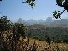
| Simien Mountains National Park
FeatureType : null
Elevation : 2322
Lat/Lng : 13.1833 / 38.0667
| Simien Mountains National Park is one of the national parks of Ethiopia. Located in the Semien (North) Gondar Zone of the Amhara Region, its territory covers the Semien Mountains and includes Ras Dashan, the highest point in Ethiopia (...) |
| 8 | | Mekane Berhan
FeatureType : null
Elevation : 2938
Lat/Lng : 12.9833 / 38.1167
| Mekane Berhan (Ge'ez: መካነ ብርሃን mekāne birhān, "Place of light") is a town in northern Ethiopia. Located in the Semien Gondar Zone of the Amhara Region, Mekane Berhan has a latitude and longitude of with an elevation of approximately 2900 meters above sea level (...) |
| 9 | | Jan Amora
FeatureType : adm3rd
Elevation : 2938
Lat/Lng : 12.9833 / 38.1167
| Jan Amora (Amharic: ጃን አሞራ jān āmōrā, "Royal eagle") is one of the woredas in the Amhara Region of Ethiopia. Part of the Semien Gondar Zone, Jan Amora is bordered on the south by Misraq Belessa, on the southwest by Wegera, on the west by Debarq, on the north by Addi Arkay and Tselemt, on the east by (...) |
| 10 | | Gai
FeatureType : null
Elevation : 2652
Lat/Lng : 12.7 / 37.4833
| Gai may refer to: == People == === Given name or nickname === * GAI (musician) (born 1987), Chinese hip-hop musician * Gai Assulin (born 1991), Israeli footballer * Gai Brodtmann (born 1963), Australian politician * Gai Eaton (1921–2010), British diplomat * Gai Toms (born 1976), Welsh musician * Gai (...) |
 by
by