| 39 records found in wikipedia | |||
| 1 | 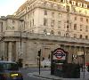
| Bank of England  FeatureType : landmark Elevation : 29 Lat/Lng : 51.5141 / -0.0884 | The Bank of England is the central bank of the United Kingdom and the model on which most modern central banks have been based. Established in 1694 to act as the English Government's banker, and still one of the bankers for the Government of the United Kingdom, it is the world's eighth-oldest bank (...) |
| 2 | Threadneedle Street FeatureType : landmark Elevation : 32 Lat/Lng : 51.5141 / -0.0868 | Threadneedle Street is a street in the City of London, England between Bishopsgate at its northeast end and Bank junction in the southwest. It is one of nine streets that converge at Bank. (...) | |
| 3 | 
| Norwich FeatureType : null Elevation : 30 Lat/Lng : 52.6283 / 1.2967 | Norwich is a cathedral city in Norfolk, England. Situated on the River Wensum in East Anglia, it lies approximately north-east of London. It is the county town of Norfolk and is considered the capital of East Anglia, with a population of 141,300 (...) |
| 4 | 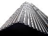
| Tower 42 FeatureType : landmark Elevation : 33 Lat/Lng : 51.5153 / -0.0839 | Tower 42 is the fourth-tallest skyscraper in the City of London, England and the ninth-tallest in Greater London. Its original name was the National Westminster Tower (commonly known as the NatWest Tower), having been built to house NatWest's international headquarters (...) |
| 5 | 
| Bank and Monument stations FeatureType : landmark Elevation : 32 Lat/Lng : 51.5133 / -0.0886 | Bank and Monument are interlinked London Underground and Docklands Light Railway stations that form a public transport complex spanning the length of King William Street in the City of London. Bank station, named after the Bank of England, opened in 1900 at Bank junction and is served by the (...) |
| 6 | 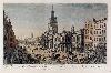
| Royal Exchange, London FeatureType : landmark Elevation : 33 Lat/Lng : 51.5136 / -0.0872 | The Royal Exchange in London was founded in the 16th century by the merchant Thomas Gresham on the suggestion of his factor Richard Clough to act as a centre of commerce for the City of London. accessed 31 July 2016 The site was provided by the City of London Corporation and the Worshipful Company (...) |
| 7 | 
| London Stock Exchange FeatureType : landmark Elevation : 25 Lat/Lng : 51.5153 / -0.1 | London Stock Exchange is a stock exchange located in the City of London, England. , London Stock Exchange had a market capitalisation of US$4.59 trillion. It was founded in 1571, making it one of the oldest exchanges in the world (...) |
| 8 | Queen Victoria Street, London FeatureType : landmark Elevation : 19 Lat/Lng : 51.512 / -0.0999 | Queen Victoria Street, named after the British monarch who reigned from 1837 to 1901, is a street in London which runs east by north from its junction with New Bridge Street and Victoria Embankment in the Castle Baynard ward of the City of London, along a section that divides the wards of Queenhithe (...) | |
| 9 | City of London FeatureType : city Elevation : 30 Lat/Lng : 51.5157 / -0.0921 | The City of London is a city and county that contains the historic centre and the primary central business district (CBD) of London. It constituted most of London from its settlement by the Romans in the 1st century AD to the Middle Ages, but the agglomeration has since grown far beyond the City's (...) | |
| 10 | Great Fire of London FeatureType : landmark Elevation : 30 Lat/Lng : 51.5157 / -0.0921 | The Great Fire of London was a major conflagration that swept through the central parts of the English city of London from Sunday, 2 September to Thursday, 6 September 1666.All dates are given according to the Julian calendar (...) | |
| 11 | Berenberg Bank FeatureType : landmark Elevation : 15 Lat/Lng : 53.5568 / 9.9919 | Joh. Berenberg, Gossler & Co. KG, commonly known as Berenberg Bank and also branded as simply Berenberg, is a Hamburg-based multinational full-service investment bank. It was founded by the Flemish-origined Berenberg family in 1590 and is the world's oldest merchant bank and also the world's oldest (...) | |
| 12 | Bank junction FeatureType : landmark Elevation : 31 Lat/Lng : 51.5134 / -0.089 | Bank junction is a major road junction in the City of London, the historic and financial centre of London, at which nine streets converge on an area where traffic is controlled by traffic lights and give-way lines. It is named after the nearby Bank of England. (...) | |
| 13 | Camberwell FeatureType : null Elevation : 10 Lat/Lng : 51.4736 / -0.0912 | Camberwell is a district of South London, England, within the London Borough of Southwark. It is located southeast of Charing Cross. The name Camberwell was first applied to the Parish of St Giles, Camberwell, which included Camberwell, Peckham, Dulwich, Nunhead, and part of Herne Hill (...) | |
| 14 | Cornhill, London FeatureType : null Elevation : 33 Lat/Lng : 51.5135 / -0.085 | Cornhill is a ward and street in the City of London, the historic nucleus and financial centre of modern London. The street runs between Bank junction and Leadenhall Street. The hill from which it takes its name is one of the three ancient hills of London; the others are Tower Hill, site of the (...) | |
| 15 | Siege of Sidney Street FeatureType : null Elevation : 17 Lat/Lng : 51.5182 / -0.0555 | The Siege of Sidney Street of January 1911, also known as the Battle of Stepney, was a gunfight in the East End of London between a combined police and army force and two Latvian revolutionaries. The siege was the culmination of a series of events that began in December 1910, with an attempted (...) | |
| 16 | Malmesbury Abbey FeatureType : landmark Elevation : 88 Lat/Lng : 51.5847 / -2.0984 | Malmesbury Abbey, at Malmesbury in Wiltshire, England, is a religious house dedicated to Saint Peter and Saint Paul. It was one of the few English houses with a continuous history from the 7th century through to the Dissolution of the Monasteries. (...) | |
| 17 | 1993 Bishopsgate bombing FeatureType : event Elevation : 35 Lat/Lng : 51.5156 / -0.0822 | The Bishopsgate bombing occurred on 24 April 1993, when the Provisional Irish Republican Army (IRA) detonated a powerful truck bomb on Bishopsgate, a major thoroughfare in London's financial district, the City of London (...) | |
| 18 | Gunthorpe, Norfolk FeatureType : null Elevation : 70 Lat/Lng : 52.873 / 0.993 | Gunthorpe is a village and a civil parish in the English county of Norfolk.OS Explorer Map 24 - Norfolk Coast Central. . The village is 8.6 miles east north east of the town of Fakenham, 14.9 miles west south west of Cromer and 122 miles north north east of London (...) | |
| 19 | Charles Stokes (collector) FeatureType : null Lat/Lng : 69.341 / -138.7524 | Charles Stokes (– 28 December 1853) was a London stockbroker who gained a reputation both as an amateur scientist and as an art collector. (...) | |
| 20 | Baltic Exchange FeatureType : landmark Elevation : 34 Lat/Lng : 51.5151 / -0.0802 | The Baltic Exchange (incorporated as The Baltic Exchange Limited) is a membership organisation for the maritime industry, and freight market information provider for the trading and settlement of physical and derivative contracts (...) | |
| 21 | Anglia Square Shopping Centre, Norwich FeatureType : null Elevation : 9 Lat/Lng : 52.6363 / 1.2952 | Anglia Square is a shopping centre in the north of Norwich city centre, in Norfolk, England. Opened in 1970, it was part of a larger Norwich redevelopment during this period, which was also complemented by the establishment of the HMSO building Sovereign House nearby, which opened in 1969 (...) | |
| 22 | 
| Stock Exchange Tower FeatureType : landmark Elevation : 32 Lat/Lng : 51.5144 / -0.0867 | 125 Old Broad Street, formerly known as the Stock Exchange Tower and still often referred to as such, is a high-rise office building in London, located on Old Broad Street in the City of London financial district (...) |
| 23 | St Martin Outwich FeatureType : landmark Elevation : 35 Lat/Lng : 51.5143 / -0.084 | St Martin Outwich was a parish church in the City of London, on the corner of Threadneedle Street and Bishopsgate. Of medieval origin, it was rebuilt at the end of the 18th century and demolished in 1874. (...) | |
| 24 | Camp for Climate Action FeatureType : null Elevation : 26 Lat/Lng : 51.4889 / -0.4453 | The Camps for Climate Action are campaign gatherings (similar to peace camps) that take place to draw attention to, and act as a base for direct action against, major carbon emitters, as well as to develop ways to create a zero-carbon society (...) | |
| 25 | Gregor MacGregor FeatureType : null Elevation : 1 Lat/Lng : 30.7047 / -81.4545 | General Gregor MacGregor (24 December 1786 – 4 December 1845) was a Scottish soldier, adventurer and confidence trickster who attempted from 1821 to 1837 to draw British and French investors and settlers to "Poyais", a fictional Central American territory that he claimed to rule as "Cazique" (...) | |
| 26 | 2009 G20 London summit protests FeatureType : null Elevation : 33 Lat/Lng : 51.5152 / -0.0825 | The 2009 G20 London summit protests occurred in the days around the 2 April 2009 G20 London summit. The summit was the focus of protests from a number of groups over various long-standing and topical issues. These ranged from disquiet over economic policy, anger at the banking system and bankers' (...) | |
| 27 | Paternoster Square FeatureType : landmark Elevation : 27 Lat/Lng : 51.5147 / -0.0994 | Paternoster Square is an urban development, owned by the Mitsubishi Estate Co., next to St Paul's Cathedral in the City of London. The area, which takes its name from Paternoster Row, once centre of the London publishing trade, was devastated by aerial bombardment in The Blitz during the Second (...) | |
| 28 | Worshipful Company of Merchant Taylors FeatureType : null Elevation : 34 Lat/Lng : 51.5141 / -0.0854 | ] The Worshipful Company of Merchant Taylors is one of the 110 livery companies of the City of London. The Company, originally known as the Guild and Fraternity of St John the Baptist in the City of London, was founded prior to 1300, first incorporated under a Royal Charter in 1327, confirmed by (...) | |
| 29 | St Benet Fink FeatureType : null Elevation : 33 Lat/Lng : 51.5139 / -0.0861 | St Benet Fink was a church and parish in the City of London located on what is now Threadneedle Street. Recorded since the 13th century, the church was destroyed in the Great Fire of London of 1666, then rebuilt to the designs of Sir Christopher Wren (...) | |
| 30 | St Bartholomew-by-the-Exchange FeatureType : landmark Elevation : 30 Lat/Lng : 51.5138 / -0.0873 | St. Bartholomew-by-the-Exchange was a church in the City of London located on Bartholomew Lane, off Threadneedle Street. Recorded since the 13th century, the church was destroyed in the Great Fire of 1666, then rebuilt by the office of Sir Christopher Wren. The rebuilt church was demolished in 1840 (...) | |
| 31 | St Christopher le Stocks FeatureType : null Elevation : 29 Lat/Lng : 51.5141 / -0.0886 | St Christopher le Stocks was a parish church on the south side of Threadneedle Street in the Broad Street Ward of the City of London. Of Medieval origin, it was rebuilt following the Great Fire of London in 1666, but demolished in 1781 to make way for an extension of the neighbouring Bank of England (...) | |
| 32 | Garrard & Co FeatureType : landmark Elevation : 31 Lat/Lng : 51.5101 / -0.1429 | Garrard & Co. Limited, formerly Asprey & Garrard Limited, designs and manufactures luxury jewellery and silver. George Wickes founded Garrard in London in 1735 and the brand is headquartered at Albemarle Street in Mayfair, London. Garrard also has a presence in a number of other locations globally (...) | |
| 33 | Dutch Church, Austin Friars FeatureType : null Elevation : 39 Lat/Lng : 51.5155 / -0.0856 | The Dutch Church, Austin Friars , is a reformed church in the Broad Street Ward, in the City of London. Located on the site of the 13th-century Augustinian friary, the original building granted to Protestant refugees for their church services in 1550 was destroyed during the London Blitz (...) | |
| 34 | Bank of England Museum FeatureType : landmark Elevation : 29 Lat/Lng : 51.5141 / -0.0881 | The Bank of England Museum is located within the Bank of England in the City of London. Its entrance is in Bartholomew Lane, off Threadneedle Street, close to Bank junction and Bank tube station. The museum is open to the general public, free of charge, on weekdays (excluding bank holidays) and on (...) | |
| 35 | Merchant Taylors' Hall, London FeatureType : landmark Elevation : 34 Lat/Lng : 51.5141 / -0.0854 | The Merchant Taylors' Hall, London is the seat of the Worshipful Company of Merchant Taylors, one of the Twelve Great Livery Companies of the City of London surviving from Mediaeval times. The Company has occupied its present site between Threadneedle Street and Cornhill since 1347 (...) | |
| 36 | Threadneedles Hotel FeatureType : landmark Elevation : 33 Lat/Lng : 51.5155 / -0.0903 | Threadneedles Hotel (formerly head offices of the London, City and Midland Bank headquarters) is a 5-star London hotel with 74 rooms and suites. The hotel is located opposite the Bank of England on Threadneedle Street. (...) | |
| 37 | St Benet Fink Church, Tottenham FeatureType : landmark Elevation : 20 Lat/Lng : 51.5974 / -0.0911 | St Benet Fink, Tottenham, is an Anglican church in Tottenham, London. (...) | |
| 38 | Bartholomew Lane FeatureType : null Elevation : 35 Lat/Lng : 51.5146 / -0.0878 | Bartholomew Lane, in the City of London, runs between the junction of Lothbury and Throgmorton Street in the north to Threadneedle Street in the south. The lane is bordered on its western side by the Bank of England. British History Online. Retrieved 5 May 2016 (...) | |
| 39 | The Mall (Bromley) FeatureType : landmark Elevation : 66 Lat/Lng : 51.4024 / 0.0173 | The Mall is a shopping centre in Bromley, South East London, United Kingdom. It is small in size and is often overshadowed by the main shopping centre in Bromley The Glades. (...) | |
 by
by