| 70 records found in wikipedia | |||
| 1 | 
| Port Harcourt  FeatureType : city Elevation : 17 Lat/Lng : 4.8242 / 7.0336 | Port Harcourt (Ikwerre: Ígúọ́cha; Pidgin: Po-ta-kot) is the capital and largest city of Rivers State, Nigeria. It lies along the Bonny River and is located in the Niger Delta. As of 2016, the Port Harcourt urban area has an estimated population of 1,865,000 inhabitants, up from 1,382,592 as of 2006 (...) |
| 2 | 
| Borneo FeatureType : isle Elevation : 245 Lat/Lng : -0.1758 / 113.6864 | Borneo is the third-largest island in the world and the largest in Asia. At the geographic centre of Maritime Southeast Asia, in relation to major Indonesian islands, it is located north of Java, west of Sulawesi, and east of Sumatra (...) |
| 3 | 
| Enugu FeatureType : city Elevation : 167 Lat/Lng : 6.4527 / 7.5103 | Enugu is the capital of Enugu State in Nigeria. It is located in southeastern Nigeria. The city had a population of 722,664 according to the 2006 Nigerian census. The name Enugu is derived from the two Igbo words Énú Ụ́gwụ́ meaning "hill top" denoting the city's hilly geography (...) |
| 4 | 
| Nigeria FeatureType : country Elevation : 6 Lat/Lng : 4.5417 / 7.9833 | The Federal Republic of Nigeria, commonly referred to as Nigeria , is a federal republic in West Africa, bordering Niger in the north, Chad in the northeast, Cameroon in the southeast, and Benin in the west. Its coast in the south is located on the Gulf of Guinea in the Atlantic Ocean (...) |
| 5 | 
| Kuwait FeatureType : country Elevation : 56 Lat/Lng : 29.3667 / 47.6333 | Kuwait (; ', or), officially the State of Kuwait (help = no), is a country in Western Asia. Situated in the northern edge of Eastern Arabia at the tip of the Persian Gulf, it shares borders with Iraq and Saudi Arabia. , Kuwait has a population of 4.2 million people: 1.3 million are Kuwaitis and 2 (...) |
| 6 | 
| Lagos FeatureType : null Elevation : 13 Lat/Lng : 6.4515 / 3.3893 | Lagos is a city in the Nigerian state of Lagos. The city, with its adjoining conurbation, is the most populous in Nigeria, and the most populous on the African continent. It is one of the fastest growing cities in the world, and also one of the most populous urban agglomerations (...) |
| 7 | 
| Breda FeatureType : city Elevation : 4 Lat/Lng : 51.5833 / 4.7833 | Breda is a city and municipality in the southern part of the Netherlands, located in the province of North Brabant. The name derived from brede Aa ('wide Aa' or 'broad Aa') and refers to the confluence of the rivers Mark and Aa (...) |
| 8 | 
| Tahiti FeatureType : isle Elevation : 824 Lat/Lng : -17.6767 / -149.4544 | Tahiti (; ; previously also known as Otaheite (obsolete) is the largest island in the Windward group of French Polynesia. The island is located in the archipelago of the Society Islands in the central Southern Pacific Ocean, and is divided into two parts: the bigger, northwestern part, Tahiti Nui, (...) |
| 9 | 
| Ivory Coast FeatureType : country Elevation : 207 Lat/Lng : 7.6667 / -5.6333 | Ivory Coast or Côte d'Ivoire, officially the Republic of Côte d'Ivoire, is a country located in West Africa. Ivory Coast's political capital is Yamoussoukro, while its economic capital and largest city is the port city of Abidjan (...) |
| 10 | 
| Somalia FeatureType : country Elevation : 273 Lat/Lng : 6.1833 / 47.0 | Somalia , officially the Federal Republic of SomaliaThe Federal Republic of Somalia is the country's name per Article 1 of the . , is a sovereign state with its territory located in the Horn of Africa. It is bordered by Ethiopia to the west, Djibouti to the northwest, the Gulf of Aden to the north, (...) |
| 11 | 
| Ibadan FeatureType : null Elevation : 234 Lat/Lng : 7.3964 / 3.9167 | Ibadan is the capital and most populous city of Oyo State, Nigeria. With a population of over 3 million, it is the third most populous city in Nigeria after Lagos and Kano; it is the country's largest city by geographical area (...) |
| 12 | 
| Tunis FeatureType : null Elevation : 42 Lat/Lng : 36.7975 / 10.1659 | Tunis (Tūnis) is the capital and the largest city of Tunisia. The greater metropolitan area of Tunis, often referred to as Grand Tunis, has some 2,700,000 inhabitants. Situated on a large Mediterranean Sea gulf (the Gulf of Tunis), behind the Lake of Tunis and the port of La Goulette (Ḥalq il-Wād), (...) |
| 13 | 
| New Britain FeatureType : isle Elevation : 360 Lat/Lng : -5.7333 / 150.7333 | New Britain is the largest island in the Bismarck Archipelago of Papua New Guinea. It is separated from the island of New Guinea by the Dampier and Vitiaz Straits and from New Ireland by St. George's Channel. The main towns of New Britain are Rabaul/Kokopo and Kimbe (...) |
| 14 | 
| Ürümqi FeatureType : city Elevation : 836 Lat/Lng : 43.825 / 87.6 | Ürümqi , abbreviated Wushi , formerly known as Tihwa , is the capital of the Xinjiang Uygur Autonomous Region in the far northwest of the People's Republic of China. Ürümqi was a major hub on the Silk Road during China's Tang dynasty, and developed its reputation as a leading cultural and commercial (...) |
| 15 | 
| Vicenza FeatureType : city Elevation : 33 Lat/Lng : 45.55 / 11.55 | Vicenza is a city in northeastern Italy. It is in the Veneto region at the northern base of the Monte Berico, where it straddles the Bacchiglione River. Vicenza is approximately west of Venice and east of Milan (...) |
| 16 | 
| Marbella FeatureType : null Elevation : 57 Lat/Lng : 36.5167 / -4.8833 | Marbella is a city and municipality in southern Spain, belonging to the province of Málaga in the autonomous community of Andalusia. It is part of the Costa del Sol and is the headquarters of the Association of Municipalities of the region; it is also the head of the judicial district that bears its (...) |
| 17 | 
| Bengal FeatureType : adm1st Elevation : 26 Lat/Lng : 24.0 / 88.0 | Bengal is a geopolitical, cultural and historical region in South Asia, specifically in the eastern part of the Indian subcontinent at the apex of the Bay of Bengal. Geographically, it is made up by the Ganges-Brahmaputra delta system, the largest such formation in the world; along with mountains in (...) |
| 18 | 
| Albania FeatureType : country Elevation : 91 Lat/Lng : 41.3333 / 19.8 | Albania , officially the Republic of Albania , is a country in Southeast Europe on the Adriatic and Ionian Sea within the Mediterranean Sea. It is bounded by Montenegro to the northwest, Kosovo to the northeast, the Republic of Macedonia to the east and Greece to the south and southeast (...) |
| 19 | 
| Madagascar FeatureType : country Elevation : 1253 Lat/Lng : -18.9167 / 47.5167 | Madagascar , officially the Republic of Madagascar , and previously known as the Malagasy Republic, is an island country in the Indian Ocean, off the coast of East Africa. The nation comprises the island of Madagascar (the fourth-largest island in the world), and numerous smaller peripheral islands (...) |
| 20 | 
| Georgia (country) FeatureType : country Elevation : 659 Lat/Lng : 42.0167 / 43.7333 | Georgia is a country in the Caucasus region of Eurasia. Located at the crossroads of Western Asia and Eastern Europe, it is bounded to the west by the Black Sea, to the north by Russia, to the south by Turkey and Armenia, and to the southeast by Azerbaijan. The capital and largest city is Tbilisi (...) |
| 21 | 
| English Channel FeatureType : waterbody Lat/Lng : 50.1836 / -0.5311 | The English Channel ("The Sleeve"; , "Sleeve Channel"; , "Sea of Brittany"; , "British Sea"; , "The Channel"), also called simply the Channel, is the body of water that separates southern England from northern France and links the southern part of the North Sea to the Atlantic Ocean (...) |
| 22 | 
| Afghanistan FeatureType : country Elevation : 1817 Lat/Lng : 34.5167 / 69.1333 | Afghanistan (; Pashto/Dari: , Pashto: Afġānistān ,The phoneme ف occurs only in loanwords in Pashto, it tends to be replaced with پ. is also an allophone of before voiced consonants; is an allophone of before voiced consonants in loanwords (...) |
| 23 | 
| Cambodia FeatureType : city Elevation : 15 Lat/Lng : 11.55 / 104.9167 | Cambodia (; also Kampuchea ; ;), officially the Kingdom of Cambodia , is a country located in the southern portion of the Indochina peninsula in Southeast Asia. It is in area, bordered by Thailand to the northwest, Laos to the northeast, Vietnam to the east and the Gulf of Thailand to the southwest (...) |
| 24 | 
| Zambia FeatureType : country Elevation : 1126 Lat/Lng : -14.1167 / 27.6333 | Zambia , officially the Republic of Zambia, is a landlocked country in south-central Africa (although some sources consider it part of east Africa), neighbouring the Democratic Republic of the Congo to the north, Tanzania to the north-east, Malawi to the east, Mozambique to the southeast, Zimbabwe (...) |
| 25 | 
| Thailand FeatureType : country Elevation : 9 Lat/Lng : 13.75 / 100.4833 | Thailand , officially the Kingdom of Thailand and formerly known as Siam, is a country at the center of the Southeast Asian Indochinese peninsula composed of 76 provinces. At and over 68 million people, Thailand is the world's 50th largest country by total area and the 21st-most-populous country (...) |
| 26 | 
| Myanmar FeatureType : country Elevation : 121 Lat/Lng : 19.75 / 96.1 | Myanmar , officially the Republic of the Union of Myanmar and also known as Burma, is a country in Southeast Asia. Myanmar is bordered by India and Bangladesh to its west, Thailand and Laos to its east and China to its north and northeast (...) |
| 27 | 
| Eritrea FeatureType : city Elevation : 2343 Lat/Lng : 15.3333 / 38.9167 | Eritrea , , officially the State of Eritrea International Organization for Standardization is a country in the Horn of Africa, with its capital at Asmara. It is bordered by Sudan in the west, Ethiopia in the south, and Djibouti in the southeast (...) |
| 28 | 
| Czech Republic FeatureType : country Elevation : 324 Lat/Lng : 49.85 / 15.4667 | The Czech Republic , also known by its short-form name, Czechia , is a landlocked country in Central Europe bordered by Germany to the west, Austria to the south, Slovakia to the east and Poland to the northeast (...) |
| 29 | 
| Armenia FeatureType : country Elevation : 992 Lat/Lng : 40.17 / 44.52 | Armenia (;"." Dictionary.com Unabridged. 2015.), officially the Republic of Armenia , is a country in the South Caucasus region of Eurasia. Located in Western AsiaThe UN places Armenia in Western Asia; the CIA World Factbook , , and Oxford Reference Online also place Armenia in Asia (...) |
| 30 | 
| Guadalcanal Campaign FeatureType : adm2nd Elevation : 5 Lat/Lng : -9.428 / 160.0548 | The Guadalcanal Campaign, also known as the Battle of Guadalcanal and codenamed Operation Watchtower by American forces, was a military campaign fought between 7 August 1942 and 9 February 1943 on and around the island of Guadalcanal in the Pacific theater of World War II (...) |
| 31 | 
| Italy FeatureType : null Elevation : 729 Lat/Lng : 42.6384 / 12.6743 | Italy , officially the Italian Republic , Council of the European Union (retrieved 13 October 2013). Central Intelligence Agency (retrieved 13 October 2013). is a country in Europe. Located in the heart of the Mediterranean Sea, Italy shares open land borders with France, Switzerland, Austria, (...) |
| 32 | 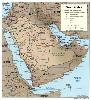
| Geography of Saudi Arabia FeatureType : country Elevation : 790 Lat/Lng : 25.0 / 45.0 | The Kingdom of Saudi Arabia is a country situated in Southwest Asia, the largest country of Arabia, by the Arabian Peninsula, bordering the Persian Gulf and the Red Sea, north of Yemen. Its extensive coastlines on the Persian Gulf and Red Sea provide great leverage on shipping (especially crude oil) (...) |
| 33 | 
| Germany FeatureType : country Elevation : 216 Lat/Lng : 51.165 / 10.4553 | Germany , officially the Federal Republic of Germany (listen), is a country in Central and Western Europe, lying between the Baltic and North seas to the north, and the Alps to the south. It borders Denmark to the north, Poland and the Czech Republic to the east, Austria and Switzerland to the (...) |
| 34 | Niger Delta FeatureType : null Elevation : 8 Lat/Lng : 5.3261 / 6.4708 | The Niger Delta is the delta of the Niger River sitting directly on the Gulf of Guinea on the Atlantic Ocean in Nigeria.C. Michael Hogan, , Washington, DC: National Council for Science and Environment, 2013. It is typically considered to be located within nine coastal southern Nigerian states, which (...) | |
| 35 | Xinjiang FeatureType : adm1st Elevation : 911 Lat/Lng : 40.714 / 85.6494 | Xinjiang (Uyghur: ; SASM/GNC: Xinjang; ; formerly romanised as Sinkiang), officially the Xinjiang Uygur Autonomous Region (XUAR), is a provincial-level autonomous region of China in the northwest of the country (...) | |
| 36 | Morobe Province FeatureType : null Elevation : 1034 Lat/Lng : -6.8333 / 146.6667 | Morobe Province is a province on the northern coast of Papua New Guinea. The provincial capital, and largest city, is Lae. The province covers 33,705 km², with a population of 674,810 (2011 census), and since the division of Southern Highlands Province in May 2012 it is the most populous province (...) | |
| 37 | Rivers State FeatureType : adm1st Elevation : 8 Lat/Lng : 4.75 / 6.8333 | Rivers State, also known simply as Rivers, is one of the 36 states of Nigeria. According to census data released in 2006, the state has a population of 5,198,716, making it the sixth-most populous state in the country (...) | |
| 38 | Pahang FeatureType : adm1st Elevation : 111 Lat/Lng : 3.75 / 102.5 | Pahang (; Jawi: ڤهڠ), officially Pahang Darul Makmur with the Arabic honorific Darul Makmur (Jawi: دار المعمور, "The Abode of Tranquility") is a sultanate and a federal state of Malaysia. It is the third largest Malaysian state by area and ninth largest by population (...) | |
| 39 | Krasnodar Krai FeatureType : adm1st Elevation : 50 Lat/Lng : 45.3667 / 39.4333 | Krasnodar Krai is a federal subject of Russia (a krai), located in the North Caucasus region in Southern Russia and administratively a part of the Southern Federal District. Its administrative center is the city of Krasnodar (...) | |
| 40 | Mekong FeatureType : waterbody Elevation : 360 Lat/Lng : 20.3556 / 100.0815 | The Mekong is a trans-boundary river in Southeast Asia. It is the world's twelfth longest river and the seventh longest in Asia. Its estimated length is , and it drains an area of , discharging of water annually (...) | |
| 41 | Sarawak FeatureType : adm1st Elevation : 200 Lat/Lng : 3.0381 / 113.7811 | Sarawak is a state of Malaysia. Being the largest among 13 other states with the size almost equal to West Malaysia, Sarawak is located in northwest Borneo Island, and is bordered by the Malaysian state of Sabah to the northeast, Kalimantan (the Indonesian portion of Borneo) to the south, and Brunei (...) | |
| 42 | Sabah FeatureType : adm1st Elevation : 371 Lat/Lng : 2.8 / 113.8833 | Sabah is a state of Malaysia located on the northern portion of Borneo Island. Sabah has land borders with the Malaysian state of Sarawak to the southwest, and Indonesia's Kalimantan region to the south. The Federal Territory of Labuan is an island just off the Sabah coast (...) | |
| 43 | Johor FeatureType : adm1st Elevation : 23 Lat/Lng : 1.4872 / 103.7811 | Johor , formerly known as Johore, is a state of Malaysia in the south of the Malay Peninsula. Johor has land borders with the Malaysian states of Pahang to the north and Malacca and Negeri Sembilan to the northwest (...) | |
| 44 | Ruhr FeatureType : landmark Elevation : 49 Lat/Lng : 51.5175 / 7.145 | The Ruhr The Ruhr may also be a shortening for Ruhr district, Ruhr region, Ruhr area or Ruhr valley is a urban area in North Rhine-Westphalia, Germany. With a population density of 2,800/km2 and a population of over 5 million (2011), it is the largest urban area in Germany, and third-largest in the (...) | |
| 45 | Sub-Saharan Africa FeatureType : null Elevation : 812 Lat/Lng : -27.9136 / 31.6475 | The sub-Saharan Africa is, geographically, the area of the continent of Africa that lies south of the Sahara. According to the United Nations, it consists of all African countries that are fully or partially located south of the Sahara (...) | |
| 46 | Indian Territory FeatureType : landmark Elevation : 213 Lat/Lng : 34.626 / -96.016 | As general terms, Indian Territory, the Indian Territories, or Indian country describe an evolving land area set aside by the United States Government for the relocation of Native Americans who held aboriginal title to their land (...) | |
| 47 | Junagadh FeatureType : null Elevation : 90 Lat/Lng : 21.5155 / 70.4564 | Junagadh pronunciation is the headquarters of Junagadh district in the Indian state of Gujarat. The city is the 7th largest in Gujarat, located at the foot of the Girnar hills, 355 km south west of state capital Gandhinagar and Ahmedabad. Literally translated, Junagadh means "Old Fort" (...) | |
| 48 | Sihanoukville (city) FeatureType : adm1st Elevation : 6 Lat/Lng : 10.6333 / 103.5 | Sihanoukville (Krong Preah Sihanouk), also known as "Kampong Som" , is a coastal city in Cambodia and the capital city of Sihanoukville Province, at the tip of an elevated peninsula in the country's south-west on the Gulf of Thailand (...) | |
| 49 | Africa FeatureType : continent Elevation : 596 Lat/Lng : 7.1881 / 21.0936 | Africa is the world's second largest and second most-populous continent (behind Asia in both categories). At about 30.3 million km2 (11.7 million square miles) including adjacent islands, it covers 6% of Earth's total surface area and 20% of its land area (...) | |
| 50 | Tripura FeatureType : adm1st Elevation : 19 Lat/Lng : 23.84 / 91.28 | Tripura is a state in Northeast India. The third-smallest state in the country, it covers and is bordered by Bangladesh to the north, south, and west, and the Indian states of Assam and Mizoram to the east. In 2011 the state had 3,671,032 residents, constituting 0.3% of the country's population (...) | |
| 51 | Republic of Artsakh FeatureType : landmark Elevation : 860 Lat/Lng : 39.8153 / 46.7519 | The Republic of Artsakh , or simply Artsakh, also known by its official name between 1991 and 2017, the Nagorno-Karabakh Republic , is a de facto independent country in the South Caucasus, internationally recognized as part of Azerbaijan (...) | |
| 52 | Aix-les-Bains FeatureType : null Elevation : 270 Lat/Lng : 45.6885 / 5.9153 | Aix-les-Bains (French:), locally called Aix, is a commune in the department of Savoie, in the southeastern French region of Auvergne-Rhône-Alpes. Situated on the shore of the largest natural lake of glacial origin in France, the Lac du Bourget, this resort is a major French spa town, and has the (...) | |
| 53 | Kingdom of Benin FeatureType : null Elevation : 86 Lat/Lng : 6.3333 / 5.6167 | The Kingdom of Benin, also known as the Benin Kingdom, was a pre-colonial kingdom in what is now southern Nigeria. Its capital was Edo, now known as Benin City in Edo state. It should not be confused with the modern-day Republic of Benin, formerly the Republic of Dahomey (...) | |
| 54 | Negros Island FeatureType : isle Elevation : 478 Lat/Lng : 10.0578 / 123.0144 | Negros is the fourth largest island of the Philippines, with a land area of . Negros is one of the many islands that comprise the Visayas, which forms the central division of the nation. The predominant inhabitants of the island region are mainly called Negrenses (locally Negrosanons) (...) | |
| 55 | Portuguese Angola FeatureType : country Elevation : 20 Lat/Lng : 2.1889 / 102.3844 | Portuguese Angola refers to Angola during the historic period when it was a territory under Portuguese rule in southwestern Africa. In the same context, it is also occasionally referred to as Portuguese West Africa (...) | |
| 56 | Lori Province FeatureType : adm1st Elevation : 2185 Lat/Lng : 40.9167 / 44.5 | Lori , is a province (marz) of Armenia. It is located in the north of the country, bordering Georgia. Vanadzor is the capital and largest city of the province. Other important towns include Stepanavan, Alaverdi, and Spitak (...) | |
| 57 | Benue State FeatureType : adm1st Elevation : 164 Lat/Lng : 7.3333 / 8.75 | Benue State is one of the South Eastern states in Nigeria with a population of about 4,253,641 in 2006 census. It is inhabited predominantly by the Tiv, Idoma and Igede peoples, who speak Tiv, Idoma, and Igede languages respectively (...) | |
| 58 | Brunei–Malaysia border FeatureType : null Lat/Lng : 4.5889 / 114.0833 | The border between Brunei and Malaysia consist of a 481.3 km land border and substantial lengths of maritime borders stretching from the coastline of the two countries to the edge of the continental shelf in the South China Sea (...) | |
| 59 | Frederick Russell Burnham FeatureType : null Elevation : 315 Lat/Lng : 36.4218 / -118.9047 | Frederick Russell Burnham DSO (May 11, 1861 – September 1, 1947) was an American scout and world-traveling adventurer. He is known for his service to the British South Africa Company and to the British Army in colonial Africa, and for teaching woodcraft to Robert Baden-Powell in Rhodesia (...) | |
| 60 | The Great Game FeatureType : null Elevation : 25 Lat/Lng : 40.02 / 52.97 | "The Great Game" was a political and diplomatic confrontation that existed for most of the nineteenth century between the British Empire and the Russian Empire over Afghanistan and neighbouring territories in Central and Southern Asia (...) | |
| 61 | Kingdom of Bonny FeatureType : null Elevation : 10 Lat/Lng : 4.4333 / 7.1667 | The Kingdom of Bonny is a traditional state based on the town of Bonny in Rivers State, Nigeria. In the pre-colonial period, it was an important slave trading port, later trading palm oil products. During the 19th century the British became increasingly involved in the internal affairs of the (...) | |
| 62 | Anambra State FeatureType : adm1st Elevation : 90 Lat/Lng : 6.3333 / 7.0 | Anambra is a state in southeastern Nigeria. Its name was inspired by one of its Northern and Omambala clans Anam but merged with "branch". The colonial masters who travelled from the present day Anambra region often described where they were coming from as Anam branch, the term coupled with (...) | |
| 63 | Ado Ekiti FeatureType : city Elevation : 439 Lat/Lng : 7.6167 / 5.2167 | Ado Ekiti is a city in southwest Nigeria, the state capital and headquarters of the Ekiti State. The population in 2006 was 308,621. The people of Ado Ekiti are mainly of the Ekiti sub-ethnic group of the Yoruba (...) | |
| 64 | Calabar River FeatureType : null Elevation : 3 Lat/Lng : 4.961 / 8.3077 | The Calabar River in Cross River State, Nigeria flows from the north past the city of Calabar, joining the larger Cross River about to the south. The river at Calabar forms a natural harbor deep enough for vessels with a draft of (...) | |
| 65 | Nembe Kingdom FeatureType : null Elevation : 3 Lat/Lng : 4.5333 / 6.4167 | The Nembe Kingdom is a traditional state in Niger Delta. It includes the Nembe and Brass Local Government Areas of Bayelsa State, Nigeria. The traditional rulers take the title "Amanyanabo". Today, leadership is split between the Amanyanabos of Ogbolomabiri, Bassambiri and Twon Brass. (...) | |
| 66 | Obafemi Awolowo University FeatureType : city Elevation : 297 Lat/Lng : 7.4667 / 4.5667 | Obafemi Awolowo University (OAU) is a federal government owned and operated Nigerian university. The university is in the ancient city of Ile-Ife, Osun State, Nigeria. The university was founded in 1961 and classes commenced in October 1962 as the University of Ife by the regional government of (...) | |
| 67 | Russian conquest of the Caucasus FeatureType : null Elevation : 717 Lat/Lng : 43.01 / 44.39 | The Russian conquest of the Caucasus mainly occurred between 1800 and 1864. In that era the Russian Empire expanded to control the region between the Black Sea and Caspian Sea, the territory that is modern Armenia, Azerbaijan, Georgia, and parts of Iran and Turkey, as well as the North Caucasus (...) | |
| 68 | Igboland FeatureType : null Elevation : 167 Lat/Lng : 6.4525 / 7.5103 | Igboland (Standard), also known as Southeastern Nigeria, is the homeland of the Igbo people.Baikie (1854) uses I´gbo as the term for Igboland: "I´gbo, as I have formerly mentioned, extends east and west, from the Old Kalabár river to the banks of the Kwóra, and possesses also some territory at Abó (...) | |
| 69 | Claude Maxwell MacDonald FeatureType : null Elevation : 55 Lat/Lng : 51.2976 / -0.6262 | Colonel Sir Claude Maxwell MacDonald, (12 June 1852 – 10 September 1915) was a British soldier and diplomat, best known for his service in China and Japan.Nish, Ian. (2004). British Envoys in Japan 1859–1972, pp. 94–102. (...) | |
| 70 | Bimbia FeatureType : null Elevation : 106 Lat/Lng : 3.9539 / 9.245 | Bimbia was an independent state of the Isubu people of Cameroon. In 1884, it was annexed by the Germans and incorporated in the colony of Kamerun. It lies in Southwest Region, to the south of Mount Cameroon and to the west of the Wouri estuary. Is situated at the East coast of the Limbé sub-division (...) | |
 by
by