| 50 records found in wikipedia | |||
| 1 | 
| Fujisawa, Kanagawa  FeatureType : null Elevation : 5 Lat/Lng : 35.3356 / 139.4933 | is a city in Kanagawa Prefecture, Japan. As of April 2018, the city had an estimated population of 429,317, and a population density of 6,171 people per km2. The total area is 69.57 km2. (...) |
| 2 | 
| Kanagawa Prefecture FeatureType : adm1st Elevation : 10 Lat/Lng : 35.4478 / 139.6425 | is a prefecture located in Kantō region of Japan.Nussbaum, Louis-Frédéric. (2005). "Kanagawa" in ; "Kantō" in . The capital of the prefecture is Yokohama.Nussbaum, "Yokohama" in . Kanagawa is part of the Greater Tokyo Area (...) |
| 3 | 
| Keio University FeatureType : edu Elevation : 25 Lat/Lng : 35.6492 / 139.7428 | , abbreviated as or , is a private university located in Minato, Tokyo, Japan. It is known as the oldest institute of modern higher education in Japan. Founder Fukuzawa Yukichi originally established it as a school for Western studies in 1858 in Edo (now Tokyo) (...) |
| 4 | 
| Niigata (city) FeatureType : null Elevation : 5 Lat/Lng : 37.9161 / 139.0197 | is the capital and the most populous city of Niigata Prefecture located in the Chūbu region of Japan. It faces the Sea of Japan and Sado Island. , the city had an estimated population of 807,450, and a population density of 1,110 persons per km2. The total area is (...) |
| 5 | 
| Kyōto Station FeatureType : landmark Elevation : 32 Lat/Lng : 34.9854 / 135.7585 | is a major railway station and transportation hub in Kyoto, Japan. It has Japan's second-largest station building (after Nagoya Station) and is one of the country's largest buildings, incorporating a shopping mall, hotel, movie theater, Isetan department store, and several local government (...) |
| 6 | 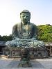
| Kamakura FeatureType : null Elevation : 9 Lat/Lng : 35.3158 / 139.5503 | is a city in Kanagawa Prefecture, Japan. Although Kamakura proper is today rather small, it is often described in history books as a former de facto capital of Japan, the nation's most populous settlement from 1200 to 1300 AD,Tertius Chandler (...) |
| 7 | 
| Tsuruoka, Yamagata FeatureType : null Elevation : 13 Lat/Lng : 38.7217 / 139.8217 | is a city in Yamagata Prefecture, Japan. , the city had an estimated population of 129,639, and a population density of 98.84 persons per km². The total area is . Tsuruoka is the biggest city in Tōhoku region in terms of surface area (...) |
| 8 | Fujisawa Station FeatureType : railwaystation Elevation : 33 Lat/Lng : 35.3372 / 139.4872 | is a railway station in Fujisawa, Kanagawa, Japan, operated by East Japan Railway Company (JR East) and the private railway operators Odakyu Electric Railway and Enoshima Electric Railway. Clustered around the station are large department stores and office buildings, forming the center of the city. (...) | |
| 9 | Ōfuna Station FeatureType : railwaystation Elevation : 18 Lat/Lng : 35.3533 / 139.5311 | is a railway station in Kamakura, Kanagawa, Japan, operated by East Japan Railway Company (JR East). (...) | |
| 10 | Iruma, Saitama FeatureType : null Elevation : 116 Lat/Lng : 35.8358 / 139.3911 | is a city located in Saitama Prefecture, Japan. , the city had an estimated population of 148,460, and a population density of 3,320 persons per km². Its total area is . (...) | |
| 11 | Matsumoto, Nagano FeatureType : city Elevation : 593 Lat/Lng : 36.2333 / 137.9667 | is a city located in Nagano Prefecture, Japan.Nussbaum, Louis-Frédéric. (2005). in Japan Encyclopedia, p. 618; at p. 126. Matsumoto is designated as a Special city.Jacobs, A.J. Urban Studies Research, (2011); ; retrieved 20132-2-11 (...) | |
| 12 | Yamato, Kanagawa FeatureType : null Elevation : 83 Lat/Lng : 35.4875 / 139.4581 | is a city located in central Kanagawa Prefecture, Japan. As of May 1, 2017, the city has an estimated population of 234,859, with 104,432 households, and a population density of 8,700 persons per km2. The total area is . (...) | |
| 13 | Ayase, Kanagawa FeatureType : null Elevation : 52 Lat/Lng : 35.4372 / 139.4269 | is a city located in Kanagawa Prefecture, Japan. It is on the east bank of the Sagami River, and is bordered by Yamato, Fujisawa and Ebina cities. It should not be confused with a neighborhood of the same name in the special ward of Adachi, Tokyo (...) | |
| 14 | Empire of Japan FeatureType : null Elevation : 13 Lat/Lng : 35.6833 / 139.7667 | The was the historical nation-state and great power that existed from the Meiji Restoration in 1868 to the enactment of the 1947 constitution of modern Japan. Japan's rapid industrialization and militarization under the slogan led to its emergence as a world power and the establishment of a colonial (...) | |
| 15 | Sagami Bay FeatureType : waterbody Lat/Lng : 35.1167 / 139.3833 | lies south of Kanagawa Prefecture in Honshu, central Japan, contained within the scope of the Miura Peninsula, in Kanagawa, to the east, the Izu Peninsula, in Shizuoka Prefecture, to the west, and the Shōnan coastline to the north, while the island of Izu Ōshima marks the southern extent of the bay (...) | |
| 16 | Fukaya, Saitama FeatureType : null Elevation : 40 Lat/Lng : 36.1975 / 139.2815 | is a city located in Saitama Prefecture, Japan. , the city had an estimated population of 144,696, and a population density of 1040 persons per km². Its total area is . It is famous for a variety of welsh onions or . (...) | |
| 17 | Musashi-Fujisawa Station FeatureType : railwaystation Elevation : 89 Lat/Lng : 35.8212 / 139.4128 | is a railway station on the Seibu Ikebukuro Line in Iruma, Saitama, Japan, operated by the private railway operator Seibu Railway. (...) | |
| 18 | Ebina, Kanagawa FeatureType : null Elevation : 26 Lat/Lng : 35.4464 / 139.3908 | is a city located in Kanagawa Prefecture, Japan. As of April 1, 2017, the city had an estimated population of 130,860, with 54,509 households, and a population density of 4,900 persons per km². The total area is 26.69 km². (...) | |
| 19 | Tōkaidō Main Line FeatureType : landmark Elevation : 15 Lat/Lng : 35.6811 / 139.7671 | The is a major Japanese railway line of the Japan Railways Group (JR Group) network, connecting and stations. It is long, not counting its many freight feeder lines around the major cities. The high-speed Tōkaidō Shinkansen largely parallels the line (...) | |
| 20 | Katase-Enoshima Station FeatureType : railwaystation Elevation : 6 Lat/Lng : 35.3089 / 139.4834 | is a railway station on the Odakyu Enoshima Line, in the city of Fujisawa, Kanagawa, Japan, operated by the private railway operator Odakyu Electric Railway. (...) | |
| 21 | Mutsuai-Nichidaimae Station FeatureType : railwaystation Elevation : 38 Lat/Lng : 35.3836 / 139.4708 | is a train station on the Odakyu Enoshima Line in the city of Fujisawa, Kanagawa, Japan. It is 49.6 rail kilometers from the terminus of the Odakyu Railway at Shinjuku Station in Tokyo. (...) | |
| 22 | Kanazawa Station FeatureType : landmark Elevation : 14 Lat/Lng : 36.5783 / 136.6478 | is a major railway station in Kanazawa, Ishikawa, Japan, operated by West Japan Railway Company (JR West), the private railway operator Hokuriku Railroad, and the third-sector operator IR Ishikawa Railway. Beneath a square in front of the JR station is Hokutetsu-Kanazawa Station, the terminal of the (...) | |
| 23 | Nihon University FeatureType : landmark Elevation : 38 Lat/Lng : 35.691 / 139.7376 | , abbreviated as , is a private research university in Japan. Yamada Akiyoshi, the Minister of Justice, founded Nihon Law School, currently the Department of Law, in October 1889. Most of the university's campuses are in the Kantō region, the vast majority in Tokyo or surrounding areas, although two (...) | |
| 24 | Enoshima Electric Railway FeatureType : landmark Elevation : 33 Lat/Lng : 35.3372 / 139.4873 | The is a private railway in Japan which connects Kamakura Station in Kamakura with Fujisawa Station in Fujisawa, Kanagawa. Stations en route include Hase, the stop closest to Kōtoku-in, the temple with the colossal outdoor statue of Amida Buddha (...) | |
| 25 | Ichinoseki, Iwate FeatureType : null Elevation : 30 Lat/Lng : 38.9167 / 141.1333 | is a city located in Iwate Prefecture, in the Tōhoku region of northern Japan. , the city had a population of 120,008 and a population density of 95.5 persons per km2 in 46,338 households . It is currently the second largest city by population in the prefecture, after Morioka (...) | |
| 26 | Shonan Monorail FeatureType : null Elevation : 9 Lat/Lng : 35.3119 / 139.4878 | The is a suspended SAFEGE monorail in the cities of Kamakura and Fujisawa in Kanagawa Prefecture, Japan. It is operated by the , and opened on March 7, 1970, the first monorail of its kind in Japan. travels every seven to eight minutes between Ōfuna Station and Enoshima, making six stops (...) | |
| 27 | Chigasaki, Kanagawa FeatureType : null Elevation : 15 Lat/Lng : 35.3339 / 139.4047 | is a city located in Kanagawa Prefecture, Japan. As of July 2016, the city has an estimated population of 239,874, and a population density of 6,719.2 persons per km2. The total area is 35.71 km2. (...) | |
| 28 | Kugenuma-Kaigan Station FeatureType : railwaystation Elevation : 6 Lat/Lng : 35.3208 / 139.4711 | is a railway station on the Odakyu Enoshima Line in Fujisawa, Kanagawa, Japan, operated by the private railway operator Odakyu Electric Railway. (...) | |
| 29 | 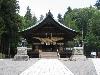
| Suwa-taisha FeatureType : landmark Elevation : 800 Lat/Lng : 36.0753 / 138.0911 | , historically also known as Suwa Shrine (諏訪神社 Suwa Jinja) or , is a group of Shinto shrines in Nagano Prefecture, Japan. The shrine complex is considered to be one of the oldest shrines in existence, being implied by the Nihon Shoki to already stand in the late 7th century. (...) |
| 30 | Enoshima FeatureType : isle Elevation : 58 Lat/Lng : 35.2997 / 139.4803 | is a small offshore island, about 4 km in circumference, at the mouth of the Katase River which flows into the Sagami Bay of Kanagawa Prefecture, Japan. Administratively, Enoshima is part of the mainland city of Fujisawa, and is linked to the eponymous Katase section of that city by a bridge (...) | |
| 31 | Totsuka-ku, Yokohama FeatureType : null Elevation : 15 Lat/Lng : 35.3964 / 139.5325 | is one of the 18 wards of the city of Yokohama in Kanagawa Prefecture, Japan. As of 2010, the ward had an estimated population of 273,418 and a density of 7,640 persons per km². The total area was 35.70 km². (...) | |
| 32 | Keio University Shonan Fujisawa Campus FeatureType : edu Elevation : 33 Lat/Lng : 35.3883 / 139.4283 | , also known as “Keio SFC” is a research-oriented campus of Keio University located in the city of Fujisawa, Kanagawa Prefecture, Japan. The campus currently offers three undergraduate courses, two postgraduate courses and incorporates one high school and several research institutes (...) | |
| 33 | Tokoro Curling Club FeatureType : null Elevation : 6 Lat/Lng : 44.1214 / 144.0561 | The is a curling club in Tokoro Town, Kitami City, Hokkaido Island, Japan. It is the home of the curling team, also known as the , a women's amateur curling team established in July 2010 by Olympian curler Mari Motohashi. The team is based in, and all the members are from Kitami City (...) | |
| 34 | Fuji-Q Highland FeatureType : landmark Elevation : 838 Lat/Lng : 35.4873 / 138.7805 | is an amusement park in Fujiyoshida, Yamanashi, Japan. it was opened on 2 March 1968. The theme park is near the base of Mount Fuji. It has a number of roller coasters, as well as two haunted attractions: the Haunted Hospital, the world's first largest haunted attraction and the newly built Hopeless (...) | |
| 35 | Hosei University FeatureType : edu Elevation : 38 Lat/Lng : 35.6956 / 139.7414 | is a long-established private university based in Tokyo, Japan. The university originated in a school of law, Tōkyō Hōgakusha (i.e. Tokyo association of law), established in 1880, and the following year renamed Tōkyō Hōgakkō (i.e. Tokyo school of law). This was from 1883 headed by Dr (...) | |
| 36 | Sakaihigashi Station FeatureType : railwaystation Elevation : 15 Lat/Lng : 34.5755 / 135.4848 | is a railway station on the Nankai Electric Railway Kōya Line in Sakai-ku, Sakai, Osaka Prefecture, Japan. It is one of the stations on the Koya Line with long history as it was the station of origin operated by Koya Railway, the predecessor of the Koya Line (...) | |
| 37 | Yamagata University FeatureType : edu Elevation : 164 Lat/Lng : 38.2544 / 140.348 | is a national university located in the Japanese cities of Yamagata, Yonezawa, and Tsuruoka in Yamagata Prefecture. The Times Higher Education released World University Rankings 2016-2017. Yamagata University ranked 600-800th out of the top 980 universities in the world (...) | |
| 38 | Kawaguchiko Station FeatureType : railwaystation Elevation : 860 Lat/Lng : 35.4983 / 138.7686 | is a railway station on the Fujikyuko Line in Fujikawaguchiko, Yamanashi, Japan, operated by Fuji Kyuko (Fujikyu). It is located at an altitude of . (...) | |
| 39 | Keio Shonan-Fujisawa Junior and Senior High School FeatureType : edu Elevation : 37 Lat/Lng : 35.3881 / 139.4272 | is located on the Shonan Fujisawa Campus of Keio University in Fujisawa, Kanagawa Prefecture, Japan. Since its founding in 1992, the school has been commonly known as Keio SFC, or simply SFC. It is one of the prestigious private junior high schools in the Tokyo area, due to its rich curriculum and (...) | |
| 40 | Izumi-ku, Yokohama FeatureType : null Elevation : 22 Lat/Lng : 35.3644 / 139.5542 | is one of the 18 wards of the city of Yokohama in Kanagawa Prefecture, Japan. In 2010 the ward had an estimated population of 155,674 and a density of 6,620 persons per km². The total area was 23.51 km². (...) | |
| 41 | Seya-ku, Yokohama FeatureType : null Elevation : 71 Lat/Lng : 35.4664 / 139.4992 | is one of the 18 wards of the city of Yokohama in Kanagawa Prefecture, Japan. As of 2010, the ward had an estimated population of 126,839 and a density of 7,390 persons per km2. The total area was 17.16 km2. (...) | |
| 42 | Sakai Station FeatureType : railwaystation Elevation : 13 Lat/Lng : 34.5817 / 135.469 | is a train station on the Nankai Main Line in Sakai-ku, Sakai, Osaka Prefecture, Japan, operated by the private railway operator Nankai Electric Railway. (...) | |
| 43 | Kamakura Station FeatureType : railwaystation Elevation : 12 Lat/Lng : 35.3191 / 139.5504 | is a railway station on the Yokosuka Line in Kamakura, Kanagawa, Japan, operated by East Japan Railway Company (JR East). (...) | |
| 44 | IBM Yamato Facility FeatureType : landmark Elevation : 91 Lat/Lng : 35.5055 / 139.4522 | IBM Yamato Facility located in the city of Yamato, Kanagawa Prefecture, Japan, is where IBM's research and development activities are done for IBM's worldwide and Asia-Pacific region market. Its buildings were designed by the architecture firm of Nikken Sekkei Ltd. and completed in 1985 (...) | |
| 45 | Sakai River (Tokyo, Kanagawa) FeatureType : river Lat/Lng : 35.3054 / 139.4812 | The Sakai River is a Class B river in Tokyo and Kanagawa Prefecture which flows into the Bay of Sagami of the Pacific Ocean. (...) | |
| 46 | Wakamiya Ōji FeatureType : null Elevation : 12 Lat/Lng : 35.3238 / 139.555 | is a 1.8 km street in Kamakura, a city in Kanagawa Prefecture in Japan, unusual because it is at the same time the city's main avenue and the approach of its largest Shinto shrine, Tsurugaoka Hachiman-gū. Over the centuries Wakamiya Ōji has gone thorough an extreme change (...) | |
| 47 | Kashio River FeatureType : river Elevation : 7 Lat/Lng : 35.3353 / 139.4933 | The is a Class B river in Kanagawa Prefecture, Japan, about 50 kilometers southwest of Tokyo. It begins in Kashio, Totsuka-ku, Yokohama at the confluence of the Akuwa River and the Hiradonagaya River and flows for 11 kilometers to the city of Fujisawa, where it merges with the Sakai River at the (...) | |
| 48 | Fukuoka Prefectural Shuyukan High School FeatureType : edu Elevation : 7 Lat/Lng : 33.5839 / 130.3566 | is a co-educational public senior high school in Fukuoka, Fukuoka, Japan. (...) | |
| 49 | Keio Media Centers (Libraries) FeatureType : null Elevation : 37 Lat/Lng : 35.3881 / 139.4272 | Keio Media Centers is the English name used by Keio University to describe its library system. The Media Centers (libraries) on the various Keio campuses are important information resources for students, faculty, and researchers (...) | |
| 50 | Koshigoe FeatureType : landmark Elevation : 6 Lat/Lng : 35.3085 / 139.4931 | is a part of the municipality of Kamakura, Kanagawa prefecture, Japan, located at the western end of the beach of Shichirigahama, near Fujisawa.Kamakura Shōkō Kaigijo (2008:60-61) The name seems to stem from the fact it was founded by people who crossed ("goe") the base ("koshi") of the mountains to (...) | |
 by
by