| 22 records found in wikipedia | |||
| 1 | 
| Tonga  FeatureType : city Elevation : 8 Lat/Lng : -21.1346 / -175.2083 | Tonga (; Tongan: Churchward, C.M. (1985) Tongan grammar, Oxford University Press, Puleʻanga Fakatuʻi ʻo Tonga), officially the Kingdom of Tonga, is a Polynesian country and archipelago comprising 169 islands, of which 36 are inhabited (...) |
| 2 | 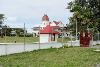
| Nukuʻalofa FeatureType : null Elevation : 8 Lat/Lng : -21.1346 / -175.2083 | Nukualofa is the capital of Tonga. It is located on the north coast of the island of Tongatapu, in the southernmost island group of Tonga. (...) |
| 3 | 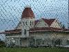
| Tongatapu FeatureType : isle Elevation : 8 Lat/Lng : -21.1672 / -175.1964 | Tongatapu is the main island of the Kingdom of Tonga and the location of its capital Nukualofa. It is located in Tonga's southern island group, to which it gives its name, and is the country's most populous island, with approximately 71,260 residents (2006), 70.5% of the national population, on (...) |
| 4 | Niuafoʻou FeatureType : null Elevation : 8 Lat/Lng : -15.6033 / -175.6369 | Niuafoou (meaning: many new coconuts) is the most northerly island in the kingdom of Tonga. It is a volcanic rim island of 15 km² and with a population of 650 in 2006. (...) | |
| 5 | Haʻapai FeatureType : isle Lat/Lng : -19.7989 / -174.3567 | Haʻapai is a group of islands, islets, reefs and shoals with an area of in the central part of the Kingdom of Tonga, with the Tongatapu group to the south and the Vavaʻu group to the north. Seventeen of the Haʻapai islands are populated with altogether 6,616 people (...) | |
| 6 | Niua Islands FeatureType : null Elevation : 52 Lat/Lng : -15.9594 / -173.783 | Niua is a division of the Kingdom of Tonga, namely the northernmost group of islands. It consists of three islands (Niuafoʻou, Niuatoputapu and Tafahi) which together have an area of 71.69 km2 and a population of 1,282. The largest village is Hihifo on Niuatoputapu (...) | |
| 7 | ʻEua FeatureType : adm1st Elevation : 173 Lat/Lng : -21.3875 / -174.9339 | Eua is a smaller but still major island in the kingdom of Tonga. It is close to Tongatapu, but forms a separate administrative division. It has an area of , and a population in 2011 of 5,016 people. (...) | |
| 8 | Kolonga FeatureType : city Elevation : 11 Lat/Lng : -21.1333 / -175.0667 | Kolonga is a village and the most populated settlement located on the northeast coast of Tongatapu in the Hahake District, Kingdom of Tonga. Kolonga is a hereditary estate of Hon. Lord Nuku. The current population of Kolonga was recorded in the Tonga 2006 Census as 1,199 (...) | |
| 9 | Late (Tonga) FeatureType : isle Elevation : 333 Lat/Lng : -18.8037 / -174.6438 | Late Island is an uninhabited volcanic island southwest of Vavaʻu in the kingdom of Tonga. The small, 6-km-wide circular island of Late, lying along the Tofua volcanic arc about 55 km WSW of the island of Vavau, contains a 400-m-wide, 150-m-deep summit crater with an ephemeral lake (...) | |
| 10 | Nomuka FeatureType : isle Elevation : 0 Lat/Lng : -20.2506 / -174.7889 | Nomuka is a small island in the southern part of the Haapai group of islands in the Kingdom of Tonga. It is part of the Nomuka Group of islands, also called the Otu Muomua. Nomuka, is 7 square kilometres in area and contains a large, brackish lake (Ano Lahi) in the middle, and also three other (...) | |
| 11 | ʻAta FeatureType : null Elevation : 48 Lat/Lng : -22.3333 / -176.2056 | Ata is a small, rocky island in the far south of the Tonga archipelago, situated on . It is also known as Pylstaart island. It should not be confused with ʻAtā, which is an uninhabited, low coral island in the string of small atolls along the Piha passage along the northside of Tongatapu, nor should (...) | |
| 12 | Vaimalō FeatureType : null Elevation : 68 Lat/Lng : -18.633 / -174.0 | Vaimalō, is a village in the western district of Vavaʻu in Tonga. Vaimalō was named by one of the most revered and beloved chiefs in Vava'u's history the great Finau Fisi. The village became the sole estate of his only child and son Naufahu Mapilitoa (...) | |
| 13 | Fonualei FeatureType : null Elevation : 166 Lat/Lng : -18.024 / -174.316 | Fonualei is an uninhabited 5 km2 volcanic island close to Vavaʻu in the kingdom of Tonga. It was seen by Don Francisco Mourelle de la Rua on the La Princesa on 26 February 1781.Sharp, Andrew, The discovery of the Pacific Islands Oxford 1960, p (...) | |
| 14 | Royal Palace, Tonga FeatureType : landmark Elevation : 6 Lat/Lng : -21.1315 / -175.2006 | The Royal Palace of the Kingdom of Tonga is located in the northwest of the capital, Nukualofa, close to the Pacific Ocean. The wooden Palace, which was built in 1867, is the official residence of the King of Tonga (...) | |
| 15 | Tupou College FeatureType : null Elevation : 25 Lat/Lng : -21.2278 / -175.1614 | Tupou College is a Methodist boys' secondary boarding school in Toloa on the island of Tongatapu, Tonga. It is located on the Eastern District of Tongatapu near the village of Malapo. The school is owned by the Free Weslyan Church of Tonga (...) | |
| 16 | Nukuleka FeatureType : city Lat/Lng : -21.15 / -175.1333 | Nukuleka is a small fishing village on the north-east coast of the island of Tongatapu, Kingdom of Tonga. In January 2008, Canadian archaeologist David V. Burley claimed that it was the "cradle of Polynesia". (...) | |
| 17 | Mapu a Vaea FeatureType : landmark Elevation : 10 Lat/Lng : -21.1759 / -175.3068 | The Mapu a Vaea or "Whistle of the Noble" are natural blowholes on the island of Tongatapu in the village of Houma in the Kingdom of Tonga. When waves crash into the reef, natural channels in the volcanic rock allow water to forcefully blow through and create a plume-like effect (...) | |
| 18 | Holonga (Tongatapu) FeatureType : city Elevation : 15 Lat/Lng : -21.192 / -175.143 | Holonga is a small village in the eastern (Hahake) district of Tongatapu in the kingdom of Tonga. It lies between the villages of Malapo and Alakifonua. (...) | |
| 19 | Vai Lahi FeatureType : isle Elevation : 8 Lat/Lng : -15.605 / -175.64 | Vai Lahi (Tongan: Big water) is the central crater lake of the Tongan island of Niuafoou. The island is the most northerly island of Tonga, is the most northerly island in the kingdom of Tonga, and is located some 570 km north of the kingdom's main island, Tongatapu (...) | |
| 20 | Malapo FeatureType : city Elevation : 14 Lat/Lng : -21.2 / -175.15 | Malapo is a small village in the eastern district of Tongatapu in the kingdom of Tonga. It is located in the fork of the road junction, where the main road to Nukualofa splits into the road to Mua and beyond and the road to the airport near Fuaamotu. It is near to the neighbouring village of Holonga (...) | |
| 21 | 1977 Tonga earthquake FeatureType : event Lat/Lng : -22.89 / -175.71 | The 1977 Tonga earthquake took place on 22 June at 12:08:33 UTC some 200 km southwest of Tongatapu, which shocks infecting all islands of the kingdom of Tonga. The earthquake measured 8.0 on the moment magnitude scale and had a maximum intensity of VIII (Severe) on the Mercalli intensity scale (...) | |
| 22 | ʻUtulau FeatureType : null Elevation : 33 Lat/Lng : -21.19 / -175.269 | ʻUtulau is a village on the western district of Tongatapu, Tonga. It is one of the estates of Crown Prince Tupoutoʻa, the heir to the Tongan throne. The traditional chief of the village is Tau'atevalu. Tupouto'a has several talking chiefs from 'Utulau namely To'amalekini, Manukainiu as well as a few (...) | |
 by
by