| 1249 records found in wikipedia | |||
| 1 | 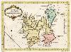
| Svalbard  FeatureType : country Lat/Lng : 78.0 / 16.0 | Svalbard (; ; prior to 1925 known by its Dutch name Spitsbergen) is a Norwegian archipelago in the Arctic Ocean. Situated north of mainland Europe, it is about midway between continental Norway and the North Pole (...) |
| 2 | 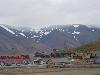
| Longyearbyen FeatureType : null Lat/Lng : 78.2177 / 15.647 | Longyearbyen ((literally The Longyear Town) is the largest settlement and the administrative centre of Svalbard, Norway. , the town had a population of 2,144. Longyearbyen is located in the Longyear Valley and on the shore of , a bay of located on the west coast of (...) |
| 3 | 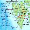
| Spitsbergen FeatureType : isle Lat/Lng : 78.75 / 16.0 | Spitsbergen (formerly known as West Spitsbergen; Norwegian: Vest Spitsbergen or Vestspitsbergen, also sometimes spelled Spitzbergen)“Of this Spitsbergen archipelago, the main island (the biggest) had the Norwegian name ‘Vest Spitsbergen’ (‘West Spitsbergen’ in English) (...) |
| 4 | 
| Bear Island (Norway) FeatureType : isle Lat/Lng : 74.4305 / 19.0329 | Bear Island is the southernmost island of the Norwegian Svalbard archipelago. The island is located in the western part of the Barents Sea, approximately halfway between Spitsbergen and the North Cape. Bear Island was discovered by the Dutch explorers Willem Barents and Jacob van Heemskerk on 10 (...) |
| 5 | 
| Barents Sea FeatureType : waterbody Lat/Lng : 75.0 / 40.0 | The Barents Sea (; , Barentsevo More) is a marginal sea of the Arctic Ocean, located off the northern coasts of Norway and Russia and is divided between Norwegian and Russian territorial waters.World Wildlife Fund, 2008 (...) |
| 6 | 
| Vatnajökull FeatureType : glacier Lat/Lng : 64.4 / -16.8 | Vatnajökull , also known as the Water Glacier in English, is the largest and most voluminous ice cap in Iceland, and one of the largest in area in Europe. It is the second largest glacier in area after Austfonna on Svalbard in Norway but, nevertheless, larger by volume (...) |
| 7 | Svalbard and Jan Mayen FeatureType : null Lat/Lng : 78.6352 / 21.9939 | Svalbard and Jan Mayen (ISO 3166-1 alpha-2: SJ, ISO 3166-1 alpha-3: SJM, ISO 3166-1 numeric: 744) is a statistical designation defined by ISO 3166-1 of two parts of Norway under separate jurisdictions—Svalbard and Jan Mayen (...) | |
| 8 | 
| Greenland Sea FeatureType : waterbody Lat/Lng : 76.6667 / -8.1667 | The Greenland Sea is a body of water that borders Greenland to the west, the Svalbard archipelago to the east, Fram Strait and the Arctic Ocean to the north, and the Norwegian Sea and Iceland to the south. The Greenland Sea is often defined as part of the Arctic Ocean,, MarBEF Data System – European (...) |
| 9 | 
| Jan Mayen FeatureType : isle Lat/Lng : 70.9833 / -8.5333 | Jan Mayen is a Norwegian volcanic island situated in the Arctic Ocean. It is long (southwest-northeast) and in area, partly covered by glaciers (an area of around the Beerenberg volcano). It has two parts: larger northeast Nord-Jan and smaller Sør-Jan, linked by a wide isthmus (...) |
| 10 | 
| Geography of Norway FeatureType : null Elevation : 11 Lat/Lng : 59.91 / 10.75 | Norway is a country located in Northern Europe on the western and northern part of the Scandinavian Peninsula, bordering the North Sea to the southwest and the Skagerrak inlet to the south, the North Atlantic Ocean (Norwegian Sea) in the west and the Barents Sea to the northeast (...) |
| 11 | 
| Franz Josef Land FeatureType : isle Lat/Lng : 80.57 / 54.78 | Franz Josef Land, Franz Joseph Land or Francis Joseph's Land is a Russian archipelago, inhabited only by military personnel, located in the Arctic Ocean, Barents Sea and Kara Sea, constituting the northernmost part of Arkhangelsk Oblast (...) |
| 12 | 
| Ny-Ålesund FeatureType : null Lat/Lng : 78.9242 / 11.9206 | Ny-Ålesund ("New Ålesund") is a research town in Oscar II Land on the island of Spitsbergen in Svalbard, Norway. It is situated on the Brøgger peninsula (Brøggerhalvøya) and on the shore of the bay of Kongsfjorden (...) |
| 13 | 
| Hinnøya FeatureType : isle Lat/Lng : 68.5333 / 15.8333 | Hinnøya is the fourth largest island in Norway (the largest island in Norway when you ignore the Svalbard archipelago). The lies just off the western coast of Northern Norway. The island sits on the border of Nordland and Troms counties (...) |
| 14 | 
| Barentsburg FeatureType : null Lat/Lng : 78.0667 / 14.2167 | Barentsburg is the second-largest settlement on Svalbard, with about 500 inhabitants (2007), almost entirely Russians and Ukrainians. It is the site of the Barentsburg Pomor Museum. (...) |
| 15 | 
| Kinnekulle FeatureType : mountain Elevation : 308 Lat/Lng : 58.6 / 13.4111 | Kinnekulle is a flat-topped mountain in the county of Västergötland, Sweden, on the eastern shore of lake Vänern. Its highest point is above sea level. The mountain is long and wide at the top. (...) |
| 16 | 
| North Pole FeatureType : null Lat/Lng : 90.0 / 0.0 | The North Pole, also known as the Geographic North Pole or Terrestrial North Pole, is (subject to the caveats explained below) defined as the point in the Northern Hemisphere where the Earth's axis of rotation meets its surface (...) |
| 17 | 
| Norway FeatureType : country Lat/Lng : 65.8333 / 13.4 | Norway (Norwegian: help=no (Bokmål) or (Nynorsk);), officially the Kingdom of Norway, is a Nordic country in Northwestern Europe whose core territory comprises the western and northernmost portion of the Scandinavian Peninsula; the remote island of Jan Mayen and the archipelago of Svalbard are also (...) |
| 18 | 
| Fram FeatureType : landmark Elevation : 9 Lat/Lng : 59.9032 / 10.6994 | Fram ("Forward") is a ship that was used in expeditions of the Arctic and Antarctic regions by the Norwegian explorers Fridtjof Nansen, Otto Sverdrup, Oscar Wisting, and Roald Amundsen between 1893 and 1912. It was designed and built by the Scottish-Norwegian shipwright Colin Archer for Fridtjof (...) |
| 19 | 
| Antarctic Peninsula FeatureType : null Lat/Lng : -69.5 / -65.0 | The Antarctic Peninsula is the northernmost part of the mainland of Antarctica, located at the base of the Southern Hemisphere. At the surface, it is the biggest, most prominent peninsula in Antarctica as it extends from a line between Cape Adams (Weddell Sea) and a point on the mainland south of (...) |
| 20 | 
| Bouvet Island FeatureType : isle Elevation : 521 Lat/Lng : -54.4215 / 3.3679 | Bouvet Island is an uninhabited subantarctic high island and dependency of Norway located in the South Atlantic Ocean at , thus putting it north of and outside the Antarctic Treaty System. It lies at the southern end of the Mid-Atlantic Ridge and is the most remote island in the world, approximately (...) |
| 21 | 
| Ben Nevis FeatureType : mountain Elevation : 1335 Lat/Lng : 56.7969 / -5.0035 | Ben Nevis is the highest mountain in the British Isles. Standing at above sea level, it is at the western end of the Grampian Mountains in the Lochaber area of the Scottish Highlands, close to the town of Fort William (...) |
| 22 | 
| German battleship Tirpitz FeatureType : landmark Lat/Lng : 69.6472 / 18.8083 | Tirpitz was the second of two s built for Nazi Germany's Kriegsmarine (navy) during World War II. Named after Grand Admiral Alfred von Tirpitz, the architect of the Kaiserliche Marine (Imperial Navy), the ship was laid down at the Kriegsmarinewerft Wilhelmshaven in November 1936 and her hull was (...) |
| 23 | 
| Grímsvötn FeatureType : mountain Lat/Lng : 64.4081 / -17.2727 | Grímsvötn (; vötn = "waters", singular:) is a volcano in southeast Iceland. It is in the highlands of Iceland at the northwestern side of the Vatnajökull ice-cap. The caldera is at , at an elevation of . Beneath the caldera is the magma chamber of the Grímsvötn volcano (...) |
| 24 | 
| Beerenberg FeatureType : mountain Lat/Lng : 71.0797 / -8.1559 | Beerenberg is a stratovolcano which forms the northeastern end of the Norwegian island of Jan Mayen. It is the world's northernmost subaerial active volcano. The volcano is topped by a mostly ice-filled crater about wide, with numerous peaks along its rim including the highest summit, Haakon VII (...) |
| 25 | Kong Karls Land FeatureType : isle Lat/Lng : 78.75 / 28.5 | Kong Karls Land or King Charles Land is an island group in the Svalbard archipelago, in the Arctic Ocean. The island group covers an area of and is made up of the islands of Kongsøya, Svenskøya, Abel Island, Helgoland Island, and Tirpitzøya (...) | |
| 26 | 
| Vostok Station FeatureType : null Lat/Lng : -78.4645 / 106.8351 | Vostok Station (literally "Station East") is a Russian research station in inland Princess Elizabeth Land, Antarctica. Founded by the Soviet Union in 1957, the station lies at the southern Pole of Cold, with the lowest reliably measured natural temperature on Earth of . National Climatic Data Center (...) |
| 27 | 
| Svartisen FeatureType : glacier Lat/Lng : 66.6581 / 13.9409 | Svartisen is a collective term for two glaciers located in northern Norway. The system consists of two separate glaciers, * Vestre (western) Svartisen (221 km2), which is the second largest glacier on the Norwegian mainland (there are larger glaciers on Svalbard) after Jostedalsbreen * Østre (...) |
| 28 | 
| Alert, Nunavut FeatureType : null Lat/Lng : 82.5014 / -62.3389 | Alert, in the Qikiqtaaluk Region, Nunavut, Canada, is the northernmost permanently inhabited place in the world, ("Twice a year, the military resupply Alert, the world's northernmost settlement.") at latitude 82°30'05" north, from the North Pole (...) |
| 29 | 
| Föhr FeatureType : isle Elevation : -1 Lat/Lng : 54.7172 / 8.4989 | Föhr pronunciation (Fering North Frisian: Feer;) is one of the North Frisian Islands on the German coast of the North Sea. It is part of the Nordfriesland district in the federal state of Schleswig-Holstein. Föhr is the second-largest North Sea island of Germany and a popular destination for (...) |
| 30 | Nathorst Land FeatureType : landmark Lat/Lng : 77.6334 / 16.2044 | Nathorst Land is the land area between Van Keulenfjorden and Van Mijenfjorden on Spitsbergen, Svalbard. The area is named after Alfred Gabriel Nathorst. The Aspelintoppen mountain is the highest peak in Nathorst Land. (...) | |
| 31 | Haakon VII Land FeatureType : landmark Lat/Lng : 79.3066 / 12.9077 | Haakon VII Land is a land area at the northwestern part of Spitsbergen, Svalbard, between Woodfjorden and Kongsfjorden. The area is named after Haakon VII of Norway. The highest mountain in Haakon VII Land is Eidsvollfjellet. (...) | |
| 32 | Sørkapp Land FeatureType : null Lat/Lng : 76.8343 / 16.3989 | Sørkapp Land is the land area south of Hornsund, at the southern part of Spitsbergen, Svalbard. Two glaciers, Hornbreen and Hambergbreen, divide Sørkapp Land from Torell Land. Sørkapp Land is included in the Sør-Spitsbergen National Park. (...) | |
| 33 | 
| Pyramiden FeatureType : city Lat/Lng : 78.6556 / 16.3333 | Pyramiden (meaning "the pyramid" in most Scandinavian languages; called Пирамида, Piramida, in Russian) is a Russian settlement and coal-mining community on the archipelago of Svalbard, Norway. Founded by Sweden. Populär Historia, 14 Mars 2001 (...) |
| 34 | 
| Senja FeatureType : isle Lat/Lng : 69.296 / 17.6413 | or is an island and future municipality in Troms county, Norway. At , it is the second largest island in Norway (outside of the Svalbard archipelago). It has a wild, mountainous outer (western) side facing the Atlantic, and a mild and lush inner (eastern) side (...) |
| 35 | Svalbard Global Seed Vault FeatureType : landmark Lat/Lng : 78.2382 / 15.4471 | The Svalbard Global Seed Vault is a secure seed bank on the Norwegian island of Spitsbergen near Longyearbyen in the remote Arctic Svalbard archipelago, about from the North Pole. Conservationist Cary Fowler, in association with the Consultative Group on International Agricultural Research (CGIAR), (...) | |
| 36 | Oscar II Land FeatureType : landmark Lat/Lng : 78.5346 / 13.1214 | Oscar II Land is the land area between Isfjorden and Kongsfjorden on Spitsbergen, Svalbard. The long glacier Sveabreen divides Oscar II Land from James I Land. The area is named after Oscar II of Sweden and Norway. Older name variants are Oscar II's Land and Terre Oscar II (...) | |
| 37 | 
| Knivskjellodden FeatureType : landmark Lat/Lng : 71.1857 / 25.6758 | Knivskjellodden or Knivskjelodden is a peninsula located in Nordkapp Municipality in Finnmark county, Norway. It is the northernmost point on the island of Magerøya in Northern Norway. It is sometimes considered the northernmost point of the entire continent of Europe (...) |
| 38 | 
| Extreme points of Europe FeatureType : mountain Lat/Lng : 71.133 / 27.647 | This is a list of the extreme points of Europe: the geographical points that are higher or farther north, south, east or west than any other location in Europe. Some of these positions are open to debate, as the definition of Europe is diverse. (...) |
| 39 | 
| Smeerenburg FeatureType : landmark Lat/Lng : 79.7317 / 10.995 | The settlement of Smeerenburg on Amsterdam Island in northwest Svalbard was founded by Danish and Dutch whalers in 1619 as one of Europe's northernmost outposts. (...) |
| 40 | Sabine Land FeatureType : landmark Lat/Lng : 78.2775 / 18.1929 | Sabine Land is a land area on the east coast of Spitsbergen, Svalbard. It is named after explorer General Sir Edward Sabine. Among the glaciers in the area is the Nordmannsfonna glacier. (...) | |
| 41 | Ny-Friesland FeatureType : landmark Lat/Lng : 79.41 / 17.56 | Ny-Friesland is the land area between Wijdefjorden and Hinlopen Strait on Spitsbergen, Svalbard. The area is named after the Dutch province of Friesland. (...) | |
| 42 | 
| Danes Island FeatureType : isle Lat/Lng : 79.6823 / 10.9424 | Danes IslandMills, William James. 2003. Exploring Polar Frontiers: A Historical Encyclopedia. Volume 1: A–L. Santa Barbara, CA: ABC Clio, p. 171.Peter Joseph Capelotti. 1999. By Airship to the North Pole: An Archaeology of Human Exploration. New Brunswick, NJ: Rutgers University Press, pp. xii ff (...) |
| 43 | Nordenskiöld Land FeatureType : landmark Lat/Lng : 78.0595 / 15.6127 | Nordenskiöld Land is the land area between Isfjorden and Van Mijenfjorden on Spitsbergen, Svalbard. The area is named after Finnish-Swedish explorer and geologist Nils Adolf Erik Nordenskiöld. The coastal region of Nordenskiöld Land (Nordenskiøldkysten) has been identified as an Important Bird Area (...) | |
| 44 | Wandel Sea FeatureType : waterbody Lat/Lng : 82.25 / -17.0 | The Wandel Sea (also known as McKinley Sea) is a body of water in the Arctic Ocean, stretching from northeast of Greenland to Svalbard. It is obstructed by ice most of the year. This sea is named after Danish polar explorer and hydrographer, Vice Admiral Carl Frederick Wandel, who in years 1895–96 (...) | |
| 45 | 
| Universal Transverse Mercator coordinate system FeatureType : null Elevation : 84 Lat/Lng : 43.6426 / -79.3871 | The Universal Transverse Mercator (UTM) conformal projection uses a 2-dimensional Cartesian coordinate system to give locations on the surface of the Earth. Like the traditional method of latitude and longitude, it is a horizontal position representation, i.e (...) |
| 46 | Svalbard Airport, Longyear FeatureType : airport Lat/Lng : 78.2452 / 15.4824 | Svalbard Airport, Longyear is the main airport serving Svalbard in Norway. It is located 1.6 nautical miles (3 km) northwest of Longyearbyen, and is the northernmost airport in the world with scheduled public flights. The first airport near Longyearbyen was constructed during World War II (...) | |
| 47 | Nordaustlandet FeatureType : isle Lat/Lng : 79.8 / 22.4 | Nordaustlandet (sometimes translated as North East Land) is the second-largest island in the archipelago of Svalbard, Norway, with an area of . It lies north east of Spitsbergen, separated by Hinlopen Strait. Much of Nordaustlandet lies under large ice caps, mainly Austfonna and Vestfonna, the (...) | |
| 48 | Newtontoppen FeatureType : landmark Lat/Lng : 79.0105 / 17.4907 | Newtontoppen (Newton Peak) is the largest and highest mountain in Svalbard, at 1,713 m. Its peak is the highest point on Svalbard. It is located at the north east corner on the island of Spitsbergen. The nearest settlement is the formerly Soviet coal mining settlement, Pyramiden (...) | |
| 49 | Vestfonna FeatureType : null Lat/Lng : 79.95 / 20.5 | Vestfonna is an ice cap located on the western part Nordaustlandet in the Svalbard archipelago in Norway. The glacier covers an area of about 2,500 km2. It is the third largest ice cap in Svalbard and Norway by area, after Austfonna and Olav V Land. (...) | |
| 50 | Hopen (Svalbard) FeatureType : isle Lat/Lng : 76.5632 / 25.0976 | Hopen is an island in the southeastern part of the Svalbard archipelago (Norway). Hopen was discovered in 1596 by Jan Cornelisz Rijp during the third expedition by Willem Barentsz, trying to find the Northeast Passage (...) | |
| 51 | Svenskøya FeatureType : isle Lat/Lng : 78.7167 / 26.6333 | Svenskøya (English: "Swedish Island") is an island in Svalbard. It is the second largest island of Kong Karls Land with an area of 137 km². Svenskøya is separated from Kongsøya by the strait Rivalensundet. The island is separated from Edgeøya and Barentsøya by the strait Olgastretet. (...) | |
| 52 | Hotellneset FeatureType : null Lat/Lng : 78.245 / 15.52 | Hotellneset ("Hotel Point") is a peninsula north-west of Longyearbyen in Svalbard, Norway, sticking out into Adventfjorden. It is the location of Svalbard Airport, Longyear and the port for shipping of coal from Longyearbyen (...) | |
| 53 | Thousand Islands (Svalbard) FeatureType : isle Lat/Lng : 77.0573 / 21.886 | Thousand IslandsVaughan, Richard. 1992. In Search of Arctic Birds. London: T & A D Poyser, p. 353.Reeves, Randall R. 1978. Atlantic Walrus (Odobenus rosmarus rosmarus): A Literature Survey and Status Report. Washington, DC: U.S. Dept. of the Interior, Fish and Wildlife Service, p. 9.Dodd, G. J., G (...) | |
| 54 | Diocese of Nord-Hålogaland FeatureType : null Lat/Lng : 69.6 / 19.5 | Nord-Hålogaland is a diocese in the Church of Norway. It covers the Church of Norway churches in Troms and Finnmark counties as well as in the territory of Svalbard. The diocese is seated in the city of Tromsø at the Tromsø Cathedral, the seat of the presiding bishop, Olav Øygard (bishop since 2014) (...) | |
| 55 | Langøya FeatureType : isle Lat/Lng : 68.622 / 14.9407 | Langøya is the third largest island of Norway (except for Svalbard), with an area of . The island is a part of the Vesterålen archipelago and is situated in Nordland county. The island includes the municipalities of Bø and Øksnes as well as parts of the municipalities of Sortland and Hadsel (...) | |
| 56 | Edgeøya FeatureType : isle Lat/Lng : 77.6667 / 22.5 | Edgeøya, occasionally anglicised as Edge Island, is a Norwegian island located in southeast of the Svalbard archipelago; with an area of , it is the third largest island in this archipelago.Norwegian Polar Institute, 2008 An Arctic island, it forms part of the Søraust-Svalbard Nature Reserve, home (...) | |
| 57 | Olav V Land FeatureType : landmark Lat/Lng : 78.8372 / 19.5397 | Olav V Land is a peninsula in eastern Spitsbergen Island, Svalbard. It is covered by the Olav V Icefield, measuring about .Glacier Atlas of Svalbard and Jan Mayen. 1993. Oslo: Norsk polarinstitutt, p. 32. The only larger ice cap in the Svalbard Archipelago is Austfonna in Nordaustlandet, with an (...) | |
| 58 | Wedel Jarlsberg Land FeatureType : landmark Lat/Lng : 77.3267 / 14.9933 | Wedel Jarlsberg Land is the land area between Van Keulenfjorden and Hornsund on the southwestern part of Spitsbergen, Svalbard. The area is largely covered with glaciers, and is completely within the Sør-Spitsbergen National Park (...) | |
| 59 | Isfjorden (Svalbard) FeatureType : null Lat/Lng : 78.3205 / 14.9854 | Isfjorden is the second longest fjord in the Norwegian archipelago of Svalbard. It lies on the west side of Spitsbergen, an island in the Arctic Ocean about midway between Norway and the North Pole, and the largest in the archipelago (...) | |
| 60 | Norwegian Polar Institute FeatureType : landmark Lat/Lng : 69.6437 / 18.9491 | The Norwegian Polar Institute (Norwegian: Norsk Polarinstitutt) is Norway's central governmental institution for scientific research, mapping and environmental monitoring in the Arctic and the Antarctic. It is run under the auspices of the Norwegian Ministry of Climate and Environment (...) | |
| 61 | Austfonna FeatureType : glacier Lat/Lng : 79.7833 / 24.6633 | Austfonna is an ice cap located on Nordaustlandet in the Svalbard archipelago in Norway. Covering an area of 8,492 km2 it is the largest ice cap by area and with 1,900 km3 (excluding Vegafonna) the second largest by volume in Europe, after the Vatnajökull in Iceland (not counting the still larger (...) | |
| 62 | Barentsøya FeatureType : isle Lat/Lng : 78.4133 / 21.5248 | Barentsøya, sometimes anglicized as Barents Island, is an island in the Svalbard archipelago of Norway, lying between Edgeøya and Spitsbergen. Barents Island has no permanent human inhabitants. Named for the Dutch explorer Willem Barents (who actually never sighted the island), it is a part of (...) | |
| 63 | Wahlenbergfjorden FeatureType : null Lat/Lng : 79.7443 / 20.7771 | Wahlenbergfjorden, sometimes known in English as Waalenburg Bay, is a fjord on the southwest coast of the Arctic island of Nordaustlandet, in Norway's Svalbard archipelago. At in length, and wide, it is the fifth longest fjord in the archipelago, and the longest on the island (...) | |
| 64 | Norwegian Sea FeatureType : waterbody Lat/Lng : 69.0 / 0.0167 | The Norwegian Sea is a marginal sea in the Arctic Ocean, northwest of Norway between the North Sea and the Greenland Sea, adjoining the Barents Sea to the northeast. In the southwest, it is separated from the Atlantic Ocean by a submarine ridge running between Iceland and the Faroe Islands (...) | |
| 65 | Woodfjorden FeatureType : null Lat/Lng : 79.5833 / 13.5 | Woodfjord is a fjord on the north shore of Spitsbergen island in the Svalbard archipelago. It is the fourth longest fjord in the Svalbard archipelago with the mouth facing north adjacent to Wijdefjord, and goes into the island, west of Andrée Land. (...) | |
| 66 | Storøya FeatureType : isle Lat/Lng : 80.0683 / 28.0609 | Storøya is an island in the Svalbard archipelago. It is located east of Nordaustlandet, separated from Nordaustlandet by the strait of Storøysundet. The southern part of the island is covered by the glacier Storøyjøkulen. Storøya is included in the Nordaust-Svalbard Nature Reserve (...) | |
| 67 | Nordenskiöld Land National Park FeatureType : null Lat/Lng : 77.8667 / 15.3167 | Nordenskiöld Land National Park lies on Spitsbergen island in the Svalbard archipelago, Norway. Its area includes also the icefree Reindalen. The park was opened in 2003. (...) | |
| 68 | Gustav Adolf Land FeatureType : null Lat/Lng : 79.5409 / 21.8102 | Gustav Adolf Land is the land area of the southwestern part of Nordaustlandet, Svalbard, south of Wahlenbergfjorden. The area is named after Gustaf VI Adolf of Sweden. (...) | |
| 69 | Sassenfjorden FeatureType : waterbody Lat/Lng : 78.4207 / 15.9192 | Sassenfjorden is a part of Isfjorden at Spitsbergen, Svalbard, in between Bünsow Land and Nordenskiöld Land. The inner branch of Sassenfjorden is named Tempelfjorden. (...) | |
| 70 | Perriertoppen FeatureType : mountain Lat/Lng : 79.1537 / 16.7797 | Perriertoppen is the second highest mountain in Svalbard, at 1712 m. It is located in the north east of the island of Spitsbergen. The mountain is late Silurian granite. (...) | |
| 71 | Edgeøyjøkulen FeatureType : waterbody Lat/Lng : 77.8276 / 23.1002 | Edgeøyjøkulen is an ice cap glacier on Edgeøya, part of the Svalbard archipelago, Norway. The glacier covers and area of about . (...) | |
| 72 | Grumant FeatureType : null Lat/Lng : 78.176 / 15.112 | Grumant was a Russian/Soviet settlement in Svalbard, Norway, established in 1912 and abandoned in 1965. The population peaked at 1,106 in 1951/52 (including Coles Bay, which served as port for Grumant). The name ‘Grumant’ is Pomor in origin, and is also used to refer to the whole of the Svalbard (...) | |
| 73 | Arctic Ocean FeatureType : waterbody Lat/Lng : 70.3256 / -148.7114 | The Arctic Ocean is the smallest and shallowest of the world's five major oceans. The International Hydrographic Organization (IHO) recognizes it as an ocean, although some oceanographers call it the Arctic Mediterranean Sea or simply the Arctic Sea, classifying it a mediterranean sea or an estuary (...) | |
| 74 | Prins Karls Forland FeatureType : isle Lat/Lng : 78.5703 / 11.1236 | Prins Karls Forland or Forlandet, occasionally anglicized as Prince Charles Foreland, is an island off the west coast of Oscar II Land on Spitsbergen in the Arctic archipelago of Svalbard, Norway. The entire island and the surrounding sea area constitutes Forlandet National Park (Forlandet (...) | |
| 75 | Wijdefjorden FeatureType : null Lat/Lng : 79.5 / 15.5 | Wijdefjord is the longest fjord in Norway's Svalbard archipelago. Wijdefjord is located in the northern portion of the island of Spitsbergen, which lies in the Arctic Ocean about midway between Norway and the North Pole, and is the largest island in the archipelago. The fjord is long (...) | |
| 76 | Hinlopen Strait FeatureType : waterbody Lat/Lng : 79.6167 / 18.7833 | Hinlopen StraitVorren, Torre O., et al. 2011. Glacial History of the Barents Sea Region. In: Jurgen Ehlers, Philip Leonard Gibbard, & Philip D. Hughes (eds.), Quaternary Glaciations – Extent and Chronology: A Closer Look, pp. 361–372. Amsterdam: Elsevier, p. 369.Conway, Martin. 1906 (...) | |
| 77 | 
| Alta Airport FeatureType : null Lat/Lng : 69.9761 / 23.3717 | Alta Airport is an international airport serving Alta, a town and municipality in Finnmark county, Norway. The airport is located at Elvebakken, northeast of Bossekop in Alta. It has a single, runway numbered 11/29, which lies on the southern shore of the Altafjord (...) |
| 78 | North Cape (Norway) FeatureType : landmark Lat/Lng : 71.1706 / 25.7858 | North Cape is a cape on the northern coast of the island of Magerøya in Northern Norway. The cape is in Nordkapp Municipality in Finnmark county, Norway. The European route E69 highway has its northern terminus at North Cape, which makes it the northernmost point in Europe that can be accessed by (...) | |
| 79 | Schengen Area FeatureType : null Elevation : 218 Lat/Lng : 54.275 / 25.5624 | The Schengen Area is an area comprising 26 European states that have officially abolished passport and all other types of border control at their mutual borders. The area mostly functions as a single jurisdiction for international travel purposes, with a common visa policy (...) | |
| 80 | Kongsøya FeatureType : isle Lat/Lng : 78.9333 / 28.5833 | Kongsøya is an island in Svalbard, Norway. It is the largest of the islands in King Charles Land (Kong Karls Land). Its area is . The other main island in the chain is Svenskøya. (...) | |
| 81 | Kvitøya FeatureType : isle Lat/Lng : 80.1514 / 32.5936 | Kvitøya (English: "White Island") is an island in the Svalbard archipelago in the Arctic Ocean, with an area of . It is located at , making it the easternmost part of the Kingdom of Norway. The closest Russian Arctic possession, Victoria Island, lies only to the east of Kvitøya (...) | |
| 82 | Barentsjøkulen FeatureType : glacier Lat/Lng : 78.429 / 21.2272 | Barentsjøkulen is a glacier on Barentsøya, Svalbard. The glacier covers an area of about . It is named after the Barents Island, which again is named after Dutch explorer Willem Barentsz. Barents Island is on the Barents Sea (...) | |
| 83 | Svalbard Satellite Station FeatureType : landmark Lat/Lng : 78.2298 / 15.4078 | Svalbard Satellite Station or SvalSat is a satellite ground station located on Platåberget near Longyearbyen in Svalbard, Norway. Opened in 1997, it is operated by Kongsberg Satellite Services (KSAT), a joint venture between Kongsberg Defence & Aerospace and the Norwegian Space Centre (NSC) (...) | |
| 84 | Harstad FeatureType : null Lat/Lng : 68.7941 / 16.5367 | or is the second-most populated municipality in Troms county, Norway. It is mostly located on the large island of Hinnøya. The municipal center is the town of Harstad, the most populous town in Central Hålogaland, and the third-largest in all of Northern Norway. The town was incorporated in 1904 (...) | |
| 85 | Ceresfjellet FeatureType : mountain Lat/Lng : 79.135 / 16.92 | Ceresfjellet is a mountain on Spitsbergen in Svalbard, Norway. At tall, it is the third-largest peak on Svalbard. It is located west of Wijdefjorden and is named for the dwarf planet Ceres. (...) | |
| 86 | Chadwickryggen FeatureType : mountain Lat/Lng : 79.095 / 16.7814 | Chadwickryggen is a mountain on Spitsbergen in Svalbard, Norway. At high, it is the fourth-largest peak on Svalbard. It is located west of Wijdefjorden between Smutsbreen and Tryggvebreen in Ny-Friesland. It is named for the English physicist James Chadwick (1891–1974). (...) | |
| 87 | Jean-Baptiste Charcot FeatureType : landmark Lat/Lng : 64.4446 / -22.2319 | Jean-Baptiste-Étienne-Auguste Charcot (15 July 1867 – 16 September 1936), born in Neuilly-sur-Seine, was a French scientist, medical doctor and polar scientist. His father was the neurologist Jean-Martin Charcot (1825–1893). (...) | |
| 88 | Vitré, Ille-et-Vilaine FeatureType : null Elevation : 101 Lat/Lng : 48.1242 / -1.2081 | Vitré is a commune in the Ille-et-Vilaine department in Brittany in northwestern France. Vitré, a sub-prefecture until 1926, is the seat of a canton of 17,798 inhabitants (2015). It lies on the edge of Brittany, near Normandy, Maine, and Anjou (...) | |
| 89 | Etonbreen FeatureType : null Lat/Lng : 79.7301 / 21.9957 | Etonbreen is a glacier on Nordaustlandet, Svalbard. The glacier debouches into Wahlenbergfjorden. It is named after Eton College. (...) | |
| 90 | University Centre in Svalbard FeatureType : edu Lat/Lng : 78.2226 / 15.6518 | The University Centre in Svalbard (; UNIS) is a Norwegian state-owned limited company that is involved in research and provides some university-level education in Arctic studies. The company is wholly owned by the Ministry of Education and Research, and the universities of Oslo, Bergen, Tromsø, NTNU (...) | |
| 91 | Sjuøyane FeatureType : isle Lat/Lng : 80.6892 / 20.7031 | Sjuøyane (English: Seven Islands) is the northernmost part of the Svalbard archipelago north of Norway, and some 20 km north of Nordaustlandet. (...) | |
| 92 | Svalbard Radio FeatureType : landmark Lat/Lng : 78.0333 / 14.2347 | Svalbard Radio is a coast radio station established in 1911 at Finneset in Svalbard, Norway. In 1930, it moved to Skjæringa in Longyearbyen and since 1975 it has been co-located with Svalbard Airport, Longyear. It has been remote-controlled from Bodø Radio since 2006. (...) | |
| 93 | Nordland FeatureType : adm1st Lat/Lng : 66.8333 / 14.6667 | Nordland is a county in Norway in the Northern Norway region, bordering Troms in the north, Trøndelag in the south, Norrbotten County in Sweden to the east, Västerbotten County to the southeast, and the Atlantic Ocean (Norwegian Sea) to the west. The county was formerly known as Nordlandene amt (...) | |
| 94 | Internet Archive FeatureType : landmark Elevation : 55 Lat/Lng : 37.7823 / -122.4716 | The Internet Archive is a San Francisco–based nonprofit digital library with the stated mission of "universal access to all knowledge." It provides free public access to collections of digitized materials, including websites, software applications/games, music, movies/videos, moving images, and (...) | |
| 95 | Albert I Land FeatureType : landmark Lat/Lng : 79.5523 / 11.4695 | Albert I Land is the land area of the northwestern part of Spitsbergen, Svalbard. It is bordered by Haakon VII Land to the southeast. To the northeast lies Raudfjorden and its inner branch, Klinckowströmfjorden, to the southeast Krossfjorden and its inner branch, Lilliehöökfjorden, to the west and (...) | |
| 96 | Nordic countries FeatureType : null Lat/Lng : 64.0 / 10.0 | The Nordic countries or the Nordics are a geographical and cultural region in Northern Europe and the North Atlantic, where they are most commonly known as Norden (literally "the North"). The term includes Denmark, Finland, Iceland, Norway, and Sweden, as well as Greenland and the Faroe (...) | |
| 97 | Nordaust-Svalbard Nature Reserve FeatureType : null Lat/Lng : 80.0 / 25.0 | Nordaust-Svalbard Nature Reserve is located in the north-eastern part of the Svalbard archipelago in Norway. The nature reserve covers all of Nordaustlandet, Kong Karls Land, Kvitøya, Sjuøyane, Storøya, Lågøya, Wilhelm Island, Wahlbergøya and a small section of the north-east corner of Spitsbergen (...) | |
| 98 | Sveagruva FeatureType : city Lat/Lng : 77.8983 / 16.7225 | Sveagruva (meaning Swedish Mine), or simply Svea, is a mining settlement in the Norwegian archipelago of Svalbard, lying at the head of Van Mijenfjord. It is the third largest settlement in the archipelago (after Longyearbyen and Barentsburg) (...) | |
| 99 | Europe FeatureType : continent Elevation : 112 Lat/Lng : 41.3275 / 19.8186 | Europe is a continent located entirely in the Northern Hemisphere and mostly in the Eastern Hemisphere. It is bordered by the Arctic Ocean to the north, the Atlantic Ocean to the west and the Mediterranean Sea to the south. It comprises the westernmost part of Eurasia (...) | |
| 100 | Governor of Svalbard FeatureType : null Lat/Lng : 78.2228 / 15.626 | The Governor of Svalbard represents the Norwegian government in exercising its sovereignty over the Svalbard archipelago (Spitsbergen). The position reports to the Norwegian Ministry of Justice, but it maintains all Norwegian interests in the area, including environmental protection, law (...) | |
| 101 | Northern Norway FeatureType : landmark Lat/Lng : 69.6667 / 19.0 | Northern Norway is a geographical region of Norway, consisting of the three northernmost counties Nordland, Troms and Finnmark, in total about 35% of the Norwegian mainland. Some of the largest towns in Northern Norway (from south to north) are Mo i Rana, Bodø, Narvik, Harstad, Tromsø and Alta (...) | |
| 102 | Glacier FeatureType : waterbody Elevation : 39 Lat/Lng : -46.689 / -73.848 | A glacier (or) is a persistent body of dense ice that is constantly moving under its own weight; it forms where the accumulation of snow exceeds its ablation (melting and sublimation) over many years, often centuries (...) | |
| 103 | Andrée Land (Svalbard) FeatureType : landmark Lat/Lng : 79.3678 / 14.7052 | Andrée Land is the land area between Wijdefjorden and Woodfjorden on Spitsbergen, Svalbard in Arctic Norway. Limited in the south by a line from Woodfjorden through Vonbreen to Holtedahlfonna eastwards to the upper part of Abrahamsenbreen through Ruskbreen, Millarpasset, Lisbetbreen and (...) | |
| 104 | Tiholmane FeatureType : isle Lat/Lng : 76.9876 / 21.92 | Tiholmane is a group of ten small islands that form part of Thousand Islands, an archipelago south of Edgeøya in Svalbard. The largest of the islands are Lurøya, Kalvøya, Langåra and Rugla. The group also includes the smaller Sperra, Spunset, Bommen, Proppen, Rullesteinøya and Røysholmen. (...) | |
| 105 | Dickson Land FeatureType : landmark Lat/Lng : 78.8382 / 15.9109 | Dickson Land is a land area between Isfjorden and Wijdefjorden at Spitsbergen, Svalbard. It forms a peninsula between the Isfjorden branches Billefjorden and Dicksonfjorden. Dickson Land is named after Oscar Dickson. (...) | |
| 106 | St. Jonsfjorden FeatureType : null Lat/Lng : 78.515 / 12.7511 | St. Jonsfjorden is a fjord in Oscar II Land at Spitsbergen, Svalbard. It has a length of 21 kilometer, and opens westwards into the strait of Forlandsundet. Several glaciers debouche into the fjord, including Gaffelbreen and Konowbreen from the north, a merge of Osbornebreen, Devikbreen, (...) | |
| 107 | Palanderbukta FeatureType : null Lat/Lng : 79.5889 / 20.6589 | Palanderbukta is a fjord or bay in Gustav Adolf Land at Nordaustlandet, Svalbard, a southern bay of Wahlenbergfjorden. The bay is named after Swedish naval officer Louis Palander. Palanderbukta has a length of about twelve nautical miles (...) | |
| 108 | Olgastretet FeatureType : null Lat/Lng : 78.372 / 24.4641 | Olgastretet (English: Olga Strait) is a strait in the Svalbard archipelago, separating Edgeøya and Barentsøya from Svenskøya of the Kong Karls Land. The strait takes its name from Olga Nikolaevna of Russia (1822-1892). (...) | |
| 109 | Vindelfjällen Nature Reserve FeatureType : null Lat/Lng : 65.9231 / 15.3178 | The Nature Reserve is a nature reserve located in the municipalities of Sorsele and Storuman in Västerbotten County of Swedish Lapland. It is the largest natural reserve in Sweden and one of the largest protected areas in Europe, totaling 562,772 ha (approx. 5,628 km2) (...) | |
| 110 | Austfjorden (Svalbard) FeatureType : landmark Lat/Lng : 79.0638 / 16.1578 | Austfjorden is a fjord in Spitsbergen, Svalbard in Arctic Norway. The fjord (East Fjord), measuring 32 kilometres (20 miles in length) is located in the east of the Indre Wijdefjorden National Park. (...) | |
| 111 | Nordfjorden (Svalbard) FeatureType : null Lat/Lng : 78.5044 / 14.7516 | Nordfjorden is a northern branch of the fjord Isfjorden at Spitsbergen, Svalbard. It is located between Bohemanneset and Kapp Thordsen, and branches further into the fjords Ekmanfjorden and Dicksonfjorden. The 30 kilometer long glacier Sveabreen debouches into the fjord. (...) | |
| 112 | 2011 Norway attacks FeatureType : event Elevation : 39 Lat/Lng : 59.915 / 10.7458 | The 2011 Norway attacks, referred to in Norway as 22 July , the date of the events, were two sequential lone wolf terrorist attacks by Anders Behring Breivik against the government, the civilian population, and a Workers' Youth League (AUF) summer camp. 77 people were killed (...) | |
| 113 | Greenpeace FeatureType : null Elevation : 1 Lat/Lng : 52.3503 / 4.8331 | Greenpeace is a non-governmental environmental organization with offices in over 39 countries and with an international coordinating body in Amsterdam, the Netherlands. Greenpeace was founded by Irving Stowe and Dorothy Stowe, Canadian and US ex-pat environmental activists in 1971 (...) | |
| 114 | Geography of Svalbard FeatureType : country Lat/Lng : 78.0 / 20.0 | Svalbard is an archipelago in the Arctic Ocean roughly centered on 78° north latitude and 20° east longitude. The archipelago is the northernmost part of the Kingdom of Norway. The three main islands in the group consist of Spitsbergen (the largest island), Nordaustlandet and Edgeøya (...) | |
| 115 | Indre Wijdefjorden National Park FeatureType : null Lat/Lng : 79.0833 / 16.1 | Indre Wijdefjorden National Park is located in a steep fjord landscape in northern Spitsbergen in Svalbard, Norway. It covers the inner part of Wijdefjorden—the longest fjord on Svalbard. The national park was established on 9 September 2005 and covers , of which is on land and is sea (...) | |
| 116 | Norwegian Directorate for Cultural Heritage FeatureType : city Elevation : 20 Lat/Lng : 59.9095 / 10.7452 | The Directorate for Cultural Heritagehttp://www.riksantikvaren.no/en/ Retrieved 2 January 2017 (or Direktoratet for kulturminneforvaltning) is a government agency responsible for the management of cultural heritage in Norway (...) | |
| 117 | Galileotoppen FeatureType : mountain Lat/Lng : 79.0333 / 17.3183 | Galileotoppen is a mountain on Spitsbergen in Svalbard, Norway. At tall, it is the fifth-tallest peak on Svalbard. It is located west of Wijdefjorden northwest of Newtontoppen in the south of Ny-Friesland. It is named for the Italian astronomer Galileo Galilei (1564–1642). (...) | |
| 118 | River Nith FeatureType : river Lat/Lng : 54.9993 / -3.5756 | The River Nith is a river in south-west Scotland. The Nith rises in the Carsphairn hills of East Ayrshire, more precisely between Prickeny Hill and Enoch Hill, 7 km east of Dalmellington. For the majority of its course it flows in a generally southern direction through Dumfries and Galloway, before (...) | |
| 119 | Hurtigruten FeatureType : null Lat/Lng : 68.7992 / 16.5483 | Hurtigruten ("Express Route", also known as the Norwegian Coastal Express) is a Norwegian cruise, ferry and cargo operator. The company was founded in 1893 to operate voyages on Norway's western and northern coast between Bergen and Kirkenes (...) | |
| 120 | Olonkinbyen FeatureType : landmark Lat/Lng : 70.9396 / -8.6678 | Olonkinbyen (literally The Olonkin Town) is one of the two settlements on the Norwegian island of Jan Mayen (the other being Puppebu). It was named after the explorer Gennady Olonkin and is the legal capital of the island (...) | |
| 121 | Van Mijenfjorden FeatureType : null Lat/Lng : 77.7909 / 15.5452 | Van Mijenfjorden is the third-longest fjord in Norway's Svalbard archipelago. It lies in the southern portion of Spitsbergen island, south of Nordenskiöld Land and north of Nathorst Land. The fjord is long, being separated from Bellsund further out by Akseløya and Mariaholmen (...) | |
| 122 | Kongsfjorden FeatureType : waterbody Lat/Lng : 79.0458 / 11.5825 | Kongsfjorden (Kongs Fjord or Kings Bay) is an inlet on the west coast of Spitsbergen, an island which is part of the Svalbard archipelago in the Arctic Ocean. The inlet is long and ranges in width from 6 to 14 km (4 to 9 miles). Two glaciers, Kronebreen and Kongsvegen, head the fjord (...) | |
| 123 | Wilhelm Island FeatureType : isle Lat/Lng : 79.0517 / 20.4344 | Wilhelm IslandNikitenko, B. L., & M. B. Mickey. 2004. Foraminifera and Ostracodes across the Pliensbachian-Toarcian Boundary in the Arctic Realm. In: Alwynne Bowyer Beaudoin & Martin J. Head (eds.), The Palynology and Micropalaeontology of Boundaries, pp. 137–174. London: The Geological Society, p (...) | |
| 124 | Adventfjorden FeatureType : waterbody Lat/Lng : 78.248 / 15.6079 | Adventfjorden (Advent Bay) is a 7 km long and 4 km wide bay on the southern side of Isfjorden, on the west coast of Spitsbergen. The name is a corruption of Adventure Bay, which was probably named after the Hull whaleship Adventure, which resorted to Isfjorden in 1656 (...) | |
| 125 | Nordre Isfjorden National Park FeatureType : null Lat/Lng : 78.4 / 14.3833 | Nordre Isfjorden National Park lies on Spitsbergen Island in the Svalbard archipelago, Norway. It lies across the Isfjorden north of Barentsburg. The park was opened in 2003. The park carries the name of the fjord Isfjorden, one of the largest fjords in Svalbard (...) | |
| 126 | Phippsøya FeatureType : isle Lat/Lng : 80.7164 / 20.793 | Phippsøya is the largest island in Sjuøyane, an archipelago north of Nordaustlandet, Svalbard in Arctic Norway. It is located some 22 km north of Nordkapp on Svaldbard proper and 8.5 km south of Rossøya, the northernmost island of the Svalbard archipelago (...) | |
| 127 | Adventdalen FeatureType : landmark Lat/Lng : 78.1952 / 15.9247 | Adventdalen Capelotti, P. J. 2000. The Svalbard Archipelago: American Military and Political Geographies of Spitsbergen and Other Norwegian Polar Territories, 1941–1950. Jefferson, NC: McFarland & Company, pp. 113ff.Schofield, Ernest, & Roy Conyers Nesbit. 1987 (...) | |
| 128 | Norwegian–British–Swedish Antarctic Expedition FeatureType : landmark Lat/Lng : -71.05 / -10.9167 | The Norwegian–British–Swedish Antarctic Expedition (also known as NBSX or NBSAE) (1949–1952) was the first Antarctica expedition involving an international team of scientists. The team members came from Norway, Sweden and the British Commonwealth of Nations. (...) | |
| 129 | Nordkapp FeatureType : null Lat/Lng : 71.017 / 25.783 | Nordkapp (; or ; or) is a municipality in Finnmark county, Norway. The administrative centre of the municipality is the town of Honningsvåg, where most residents live. Other settlements in Nordkapp include the villages of Gjesvær, Kåfjord, Kamøyvær, Kjelvik, Nordvågen, Repvåg, Skarsvåg, and Valan (...) | |
| 130 | 
| Andøya Space Center FeatureType : landmark Lat/Lng : 69.2942 / 16.0208 | Andøya Space Center, formerly named Andøya Rocket Range, is a rocket launch site and rocket range on Andøya island (the northernmost in the Vesterålen archipelago) in Andøy municipality in northern Norway. Since 1962, over 1,200 sounding rockets of all known configurations have been launched from (...) |
| 131 | Sassen–Bünsow Land National Park FeatureType : null Lat/Lng : 78.3833 / 17.25 | Sassen – Bünsow Land National Park lies on Spitsbergen island in the Svalbard archipelago, Norway. The park was opened in 2003 and includes both glaciers and several glacially carved valleys. The sealer/whaler Hilmar Nøis built the hunting station Fredheim on the north side of the Sassen river (...) | |
| 132 | Bünsow Land FeatureType : landmark Lat/Lng : 78.5361 / 16.9986 | Bünsow Land is a land area at the inner end of Isfjorden at Spitsbergen, Svalbard. It forms a peninsula between Billefjorden and Sassenfjorden and Tempelfjorden. Bünsow Land is named after Friedrich Christian Ernestus Bünsow. Bünsow Land is included in the Sassen – Bünsow Land National Park. (...) | |
| 133 | Storfjorden (Svalbard) FeatureType : null Lat/Lng : 77.8241 / 19.6806 | Storfjorden (English: Great Fjord) is the body of water separating Spitsbergen in the west from Barentsøya and Edgeøya to the east. Its southern limits are Kikutodden in Sørkapp Land east to Håøya, Tiholmane, Brækmoholmane, and Menkeøyane in Thousand Islands and northeast to Negerpynten—the (...) | |
| 134 | Bastian Islands FeatureType : isle Lat/Lng : 78.9903 / 21.3411 | The Bastian IslandsHrouda, František. 1982. Magnetic Anisotropy of Rocks and Its Application in Geology and Geophysics. Geophysical Surveys 5: 37–82.Norwegian Expedition to Svalbard, 1938. 1939. Polar Record 3(17): 5–6.40-Year-Old Arctic Mystery Solved. 1937. The Straits Times (September 10): 17 (...) | |
| 135 | Operation Haudegen FeatureType : landmark Lat/Lng : 80.0487 / 22.5204 | Operation Haudegen (Operation Swashbuckler or Unternehmen Haudegen in German) was the name of a German operation during the Second World War to establish meteorological stations on Svalbard. In September 1944, the submarine U-307 and the supply ship Carl J (...) | |
| 136 | Vegafonna FeatureType : glacier Lat/Lng : 79.4508 / 21.1178 | Vegafonna is an ice cap in Gustav Adolf Land on Nordaustlandet in the Svalbard archipelago. It is located on the peninsula Scaniahalvøya, between the bay Palanderbukta to the north and Torellneset to the south. The glacier is named after the vessel SS Vega (...) | |
| 137 | Tromsø Airport, Langnes FeatureType : airport Lat/Lng : 69.6814 / 18.9178 | Tromsø Airport, Langnes is an international airport located at Langnes in the city of Tromsø in Tromsø Municipality, Troms county, Norway. Situated on the western shore of the island of Tromsøya, it features a runway aligned 01/19 (...) | |
| 138 | Operation Gauntlet FeatureType : isle Lat/Lng : 78.75 / 16.0 | Operation Gauntlet was an Allied Combined Operation from 25 August until 3 September 1941 during the Second World War. Canadian, British and Free Norwegian Forces landed on the Norwegian island of Spitsbergen in the Svalbard Archipelago, south of the North Pole (...) | |
| 139 | Sorgfjorden FeatureType : landmark Lat/Lng : 79.9011 / 16.7672 | Sorgfjorden is a fjord at the northeastern coast of Spitsbergen, Svalbard. It cuts into Ny-Friesland, from the northern part of Hinlopen Strait. It is also called Treurenberg Bay. (...) | |
| 140 | Murchisonfjorden FeatureType : null Lat/Lng : 80.0031 / 18.4852 | Murchisonfjorden is a fjord in Gustav V Land at Nordaustlandet, Svalbard. The fjord cuts eastwards from Hinlopen Strait into Nordaustlandet. It has steep coasts and numerous islands. Murchisonfjorden is named after British geologist Roderick Murchison. (...) | |
| 141 | Leighbreen FeatureType : null Lat/Lng : 80.1494 / 26.4741 | Leighbreen is a glacier on Nordaustlandet, Svalbard. It is located near the northeastern coast. The glacier is named after British explorer Benjamin Leigh Smith, who visited the archipelago several times in the 1870s and 1880s. (...) | |
| 142 | Deltabreen FeatureType : null Lat/Lng : 77.5807 / 23.1528 | Deltabreen (The Delta Glacier) is a glacier at Edgeøya, Svalbard. The glacier debouches into the lagoon of Tjuvfjordlaguna, at the eastern side of Dyrdalen. (...) | |
| 143 | Brennevinsfjorden FeatureType : null Lat/Lng : 80.3373 / 19.398 | Brennevinsfjorden is a fjord in Gustav V Land at Nordaustlandet, Svalbard. The fjord has a length of about eleven nautical miles, and runs in between Depotodden and Kapp Hansteen. (...) | |
| 144 | Ayerfjorden FeatureType : null Lat/Lng : 79.695 / 12.07 | Ayerfjorden is the western branch of Raudfjorden in Albert I Land at Spitsbergen, Svalbard. The glacier Chauveaubreen debouches into the fjord. (...) | |
| 145 | Dicksonfjorden FeatureType : null Lat/Lng : 78.6413 / 15.3296 | Dicksonfjorden is a fjord branch of Isfjorden at Spitsbergen, Svalbard. It is located between James I Land and Dickson Land, and is named after Swedish Baron Oscar Dickson. (...) | |
| 146 | Nordvestøyane FeatureType : null Lat/Lng : 79.8414 / 11.4596 | Nordvestøyane (The Northwestern Islands) is an archipelago in Albert I Land at Spitsbergen, Svalbard. Among the islands in the group are Fuglesongen (4.1 km²) and Klovningen (2.2 km²). (...) | |
| 147 | Hornsundtind FeatureType : null Lat/Lng : 76.9206 / 16.1411 | Hornsundtind is a mountain south of the fjord Hornsund at the southern part of Spitsbergen, Svalbard. Its height is 1,431 metres. (...) | |
| 148 | Alkefjellet FeatureType : null Lat/Lng : 79.5848 / 18.4608 | Alkefjellet is a cliff in Lomfjordhalvøya in Ny-Friesland at Spitsbergen, Svalbard. Alkefjellet is a bird cliff facing towards Hinlopen Strait. (...) | |
| 149 | Duvefjorden FeatureType : null Lat/Lng : 80.3672 / 23.6661 | Duvefjorden is a fjord at the northern side of Nordaustlandet, Svalbard. The fjord has a length of about and a width of 12 to 13 km. Former names of the fjord include Baye du Pigeon, Dove Bay, Tauben Bai and Duiven-baai. (...) | |
| 150 | Sørdomen FeatureType : null Lat/Lng : 79.6179 / 23.5172 | Sørdomen (The Southern Dome) is an ice dome of Austfonna at Nordaustlandet, Svalbard. The glacier cap of Austfonna has two significant ice domes, Sørdomen and Norddomen further north. The part of Austfonna west of Sørdomen is called Palanderisen. (...) | |
| 151 | Monacobreen FeatureType : waterbody Lat/Lng : 79.3983 / 12.6067 | Monacobreen is a glacier in Haakon VII Land on Spitsbergen, Svalbard. The glacier debouches into Liefdefjorden. Former names of the glacier include Glacier de Monaco and Liefde Bay-bræ. (...) | |
| 152 | Lady Franklinfjorden FeatureType : null Lat/Lng : 80.227 / 18.9405 | Lady Franklinfjorden is a fjord in Gustav V Land at Nordaustlandet, Svalbard. The fjord has a length of about 25 kilometers. Lady Franklinfjorden is named after Jane Franklin, the wife of Arctic explorer John Franklin. (...) | |
| 153 | Nybyen FeatureType : null Lat/Lng : 78.2 / 15.59 | Nybyen is a small settlement located on the southern outskirts of Longyearbyen, on the island of Spitsbergen, in the Svalbard archipelago of Norway. The name is Norwegian and translates as The New Town. (...) | |
| 154 | Airship Italia FeatureType : null Lat/Lng : 81.2333 / 28.2333 | Airship Italia was a semi-rigid airship belonging to the Italian Air Force. It was used by Italian engineer and General Umberto Nobile in his second series of flights around the North Pole. It crashed in 1928, with one confirmed fatality from the crash, one fatality from exposure while awaiting (...) | |
| 155 | Gustav V Land FeatureType : null Lat/Lng : 79.9838 / 20.67 | Gustav V Land is a land area comprising the peninsula on the northwestern part of Nordaustlandet, Svalbard in Arctic Norway. It constitutes roughly one quarter of the island's area, approximately 4000 km2, being some 80 km wide east–west and 85 km north–south, connected to the rest of the island by (...) | |
| 156 | Operation Fritham FeatureType : null Lat/Lng : 78.0 / 16.0 | Operation Fritham (30 April – 14 May 1942) was an Allied military operation during the Second World War to secure the coal mines on Spitsbergen, the main island of the Svalbard Archipelago, from the North Pole and about the same distance from Norway (...) | |
| 157 | Sassendalen FeatureType : landmark Lat/Lng : 78.2667 / 17.1 | Sassendalen is a valley at Spitsbergen, Svalbard. The valley is among the largest valleys of Svalbard, and continues westwards into Sassenfjorden. Part of the valley divides Sabine Land and Nordenskiöld Land . The river Sassenelva runs through the valley. (...) | |
| 158 | Foynøya FeatureType : null Lat/Lng : 80.4494 / 26.1533 | Foynøya is an island off the coast of Nordaustlandet, Svalbard. Sources give the size as about or about . The island is named after whaling pioneer Svend Foyn. Previous names include Walrus Eyland, Föyen's Island and Foyn Island. The island is part of the Nordaust-Svalbard Nature Reserve. (...) | |
| 159 | Extreme points of Norway FeatureType : null Lat/Lng : 80.829 / 20.3423 | The extreme points of Norway include the coordinates that are farther north, south, east or west than any other location in Norway; and the highest and the lowest altitudes in the country. The northernmost point is Rossøya on Svalbard, the southernmost is Pysen in Mandal, the easternmost is (...) | |
| 160 | Convoy PQ 18 FeatureType : null Lat/Lng : 75.0 / 40.0 | Convoy PQ 18 was an Arctic convoy of forty Allied freighters from Scotland and Iceland to Arkhangelsk in the Soviet Union in the war against Nazi Germany. The convoy departed Loch Ewe, Scotland on 2 September 1942, rendezvoused with more ships and escorts at Iceland and arrived at Arkhangelsk on 21 (...) | |
| 161 | Hitra (island) FeatureType : isle Lat/Lng : 63.5439 / 8.7562 | Hitra is an island in Hitra municipality in Trøndelag county, Norway. The island is the 7th largest island in Norway (excluding Svalbard) and it is the largest island south of the Lofoten archipelago. The island lies between the Trondheimsleia strait and the Frøyfjorden, just southwest of the (...) | |
| 162 | Svalbard Church FeatureType : landmark Lat/Lng : 78.2198 / 15.6187 | Svalbard Church is located at Longyearbyen in Svalbard, Norway. It was the northernmost church in the world, before the St. Nicolas church was built in Nagurskoye, Russia. The first church at Longyearbyen was consecrated on August 28, 1921 (...) | |
| 163 | Fram Strait FeatureType : null Lat/Lng : 78.0 / 0.0 | The Fram Strait is the passage between Greenland and Svalbard, located roughly between 77°N and 81°N latitudes and centered on the prime meridian. The Greenland and Norwegian Seas lie south of Fram Strait, while the Nansen Basin of the Arctic Ocean lies to the north (...) | |
| 164 | Operation Gearbox II FeatureType : null Lat/Lng : 78.0 / 16.0 | Operation Gearbox II (17 September 1942 – 7 September 1943) was a Norwegian and British operation during the Second World War on the Arctic island of Spitzbergen in the Svalbard Archipelago. Operation Fritham, the first attempt to establish a base had been defeated when the two ships carrying the (...) | |
| 165 | Operation Gearbox FeatureType : null Lat/Lng : 78.0 / 16.0 | Operation Gearbox (30 June – 17 September 1942) was a Norwegian and British operation on the Arctic island of Spitzbergen in the Svalbard Archipelago, during the Second World War. Operation Fritham, an earlier expedition in two ships, arrived on 13 May but met disaster after being spotted by a (...) | |
| 166 | 25th meridian east FeatureType : null Lat/Lng : 90.0 / 25.0 | The meridian 25° east of Greenwich is a line of longitude that extends from the North Pole across the Arctic Ocean, Europe, Africa, the Indian Ocean, the Southern Ocean, and Antarctica to the South Pole. The 25th meridian east forms a great circle with the 155th meridian west (...) | |
| 167 | Lågøya FeatureType : isle Lat/Lng : 80.3038 / 18.3464 | Lågøya is an island in Svalbard, Norway. It is situated north west of Nordaustlandet. The area is 103.5 km². The island has rarely been visited. Lågøya was first marked on the Muscovy Company’s map (1625) as Purchas plus ultra Island. Cornelis Giles and Outger Rep (c. 1710) labeled it t' Lage eyl (...) | |
| 168 | Sør-Spitsbergen National Park FeatureType : null Lat/Lng : 77.15 / 16.2833 | Sør-Spitsbergen National Park encompasses the southern end of Spitsbergen island in the Svalbard archipelago, Norway. The park was opened in 1973 and includes Wedel Jarlsberg Land, Torell Land and Sørkapp Land. Over 65% of the region is ice cap, with much of the rest tundra. (...) | |
| 169 | Freemansundet FeatureType : waterbody Lat/Lng : 78.2279 / 21.6868 | Freemansundet is the sound separating Barentsøya, to the north, from Edgeøya, in the Svalbard archipelago, Norway. It is named after Alderman Ralph Freeman, who was involved in the English whaling trade in the early 17th century.W. M. Conway, 1906 (...) | |
| 170 | Common minke whale FeatureType : null Lat/Lng : 78.0333 / 11.7167 | The common minke whale or northern minke whale (Balaenoptera acutorostrata) is a species of minke whale within the suborder of baleen whales. It is the smallest member of the rorquals and the second smallest species of baleen whale (...) | |
| 171 | Nordaustpynten FeatureType : null Lat/Lng : 78.9148 / 29.6224 | Nordaustpynten is a headland at Kongsøya of the Kong Karls Land, Svalbard, the most northeastern point of the island. (...) | |
| 172 | 1619 FeatureType : null Elevation : 5 Lat/Lng : 32.5 / 130.6 | == Events == === January–June === * January – James I of England's Banqueting House, Whitehall in London is destroyed by fire. Inigo Jones is commissioned to design a replacement. * March – Battle of Sarhu: Manchu leader Nurhaci is victorious over the Ming forces (...) | |
| 173 | RV Belgica (1884) FeatureType : landmark Lat/Lng : 68.795 / 16.5936 | Belgica was a barque-rigged steamship that was built in 1884 by Christian Brinch Jørgensen at Svelvik, Norway as the whaler Patria. In 1896, she was purchased by Adrien de Gerlache for conversion to a research ship, taking part in the Belgian Antarctic Expedition of 1897–1901, becoming the first (...) | |
| 174 | Platåberget FeatureType : mountain Lat/Lng : 78.2236 / 15.4531 | Platåberget is a mountain in Nordenskiöld Land on the island of Spitsbergen in Svalbard, Norway. It is tall and has a distinct plateau shape, for which it is named. It is bordered to the west by Bjørndalen, to the east by Blomsterdalen and to the north by Hotellneset and Adventfjorden (...) | |
| 175 | His Dark Materials FeatureType : null Lat/Lng : 60.7833 / 21.4 | His Dark Materials is an epic trilogy of fantasy novels by Philip Pullman consisting of Northern Lights (1995) (published as The Golden Compass in North America), The Subtle Knife (1997), and The Amber Spyglass (2000) (...) | |
| 176 | Brochøya FeatureType : isle Lat/Lng : 80.453 / 25.9825 | Brochøya is an island off the north coast of Nordaustlandet, Svalbard. The island is named after politician and physicist Ole Jacob Broch. Brochøya is located west of Foynøya, is part of Orvin Land and is included in the Nordaust-Svalbard Nature Reserve. (...) | |
| 177 | Rossøya FeatureType : isle Lat/Lng : 80.825 / 20.3417 | Rossøya, sometimes referred to as Ross Island in English, is an island located in the Arctic Ocean. It is a part of Sjuøyane, a group of islands in the Svalbard archipelago, some 20 km north of the coast of Nordaustlandet (...) | |
| 178 | Solar eclipse of March 20, 2015 FeatureType : null Lat/Lng : 64.4256 / -6.6358 | A total solar eclipse occurred on March 20, 2015. A solar eclipse occurs when the Moon passes between Earth and the Sun, thereby totally or partly obscuring the image of the Sun for a viewer on Earth. A total solar eclipse occurs when the Moon's apparent diameter is larger than the Sun's, blocking (...) | |
| 179 | Vesle Tavleøya FeatureType : isle Lat/Lng : 80.8245 / 20.35 | Vesle Tavleøya is the larger island of the two northernmost of Sjuøyane - the other being Rossøya, north of Nordaustlandet, Svalbard. Vesle Tavleøya is situated some 7 km northeast of Phippsøya, the largest island of the islands, separated by Sjuøyflaket sound. (...) | |
| 180 | Brækmoholmane FeatureType : isle Lat/Lng : 77.0676 / 22.4781 | Brækmoholmane is an island group composed of three islands, Store Brækmoholmen, Trønderen and Alkekongen. They form part of Thousand Islands, an archipelago south of Edgeøya. The islands are named after the Norwegian sailor and fisherman Sivert Brækmo (1853-1930), who visited Svalbard regularly (...) | |
| 181 | Kræmerpynten FeatureType : landmark Lat/Lng : 80.2186 / 33.5006 | Kræmerpynten is the most eastern point of Kvitøya, Svalbard. The point is also the most eastern point of Norway, 33° 30' 59 E. The name Kræmerpynten originates from captain and Spitsbergen trapper Waldemar Hilbert Kræmer. (...) | |
| 182 | Grampianfjella FeatureType : null Lat/Lng : 78.6239 / 10.9408 | Grampianfjella is a mountain ridge in Prins Karls Forland, Svalbard. The ridge is named after the Scottish Grampian Mountains. Among the mountains of the ridge are Monacofjellet, Jessiefjellet, Charlesfjellet, Parnasset, Phippsaksla, Nipenosa, Phippsfjellet, Djevletommelen, Klørne, Neglene and (...) | |
| 183 | Recherchebreen FeatureType : null Lat/Lng : 77.4368 / 14.8192 | Recherchebreen is a glacier in Wedel Jarlsberg Land at Spitsbergen, Svalbard. The glacier has a length of about . It is located in a valley between Martinfjella and Observatoriefjellet, and debouches into Recherche Fjord (...) | |
| 184 | Reuschhalvøya FeatureType : null Lat/Lng : 79.6041 / 11.1887 | Reuschhalvøya is a peninsula in Albert I Land at Spitsbergen, Svalbard. The peninsula is named after geologist Hans Henrik Reusch. It is located south of Smeerenburgfjorden and Bjørnfjorden, and north of Magdalenefjorden (...) | |
| 185 | Rijpfjorden FeatureType : null Lat/Lng : 80.2075 / 22.1094 | Rijpfjorden is a fjord at the northern side of Nordaustlandet, Svalbard. The fjord has a length of about and a width of about . Former names of the fjord include Rypefjorden, Red Currant Bay and Ripsbai. The fjord is named after Dutch explorer Jan Rijp, who never came anywhere near it. (...) | |
| 186 | Vaigattøyane FeatureType : null Lat/Lng : 79.3181 / 20.0197 | Vaigattøyane is a group of islands in Hinlopen Strait, between Spitsbergen and Nordaustlandet of the Svalbard archipelago. The island group is named after Waygat, a previous name of Hinlopenstretet. The largest island of the group is Wahlbergøya, while other islands are Von Otterøya, Nyströmøya and (...) | |
| 187 | Duckwitzbreen FeatureType : null Lat/Lng : 78.3472 / 20.9049 | Duckwitzbreen is a glacier on Barentsøya, Svalbard. It is an offshoot of Barentsjøkulen, reaching down to the sea in the western direction. The glacier is named after German politician Arnold Duckwitz. (...) | |
| 188 | Yoldiabukta FeatureType : null Lat/Lng : 78.4879 / 14.3507 | Yoldiabukta is a bay in Nordfjorden at Spitsbergen, Svalbard. It has a width of about and is located between the northern side of Bohemanflya and Muslingodden. The long glacier Wahlenbergbreen debouches into Yoldiabukta. (...) | |
| 189 | Grøndalen FeatureType : null Lat/Lng : 77.9964 / 14.6473 | Grøndalen is a valley in Nordenskiöld Land at Spitsbergen, Svalbard. It has a length of about 19 kilometers. The valley stretches westwards from the mountain pass Grøndalspasset, and debouches into Grønfjorden, at the eastern side of the fjord. The river Grøndalselva flows through the valley. (...) | |
| 190 | Yellow River Station (Arctic) FeatureType : null Lat/Lng : 78.9167 / 11.9333 | The Arctic Yellow River Station was established by the Polar Research Institute of China in Ny-Ålesund, on Svalbard, in 2003. Scientists at the station conducted research into the Aurora Borealis and microbes in the ice-pack, glacier monitoring, atmospheric research. (...) | |
| 191 | Brånevatnet FeatureType : waterbody Lat/Lng : 79.788 / 22.004 | Brånevatnet ("Melting lake") is a lake at Nordaustlandet, Svalbard. It is located between Winsnesbreen and Oxfordhalvøya, to the north of Etonbreen. The river of Oxfordelva flows from Brånevatnet through Oxfordhalvøya and debouches into Bodleybukta. (...) | |
| 192 | Möllerfjorden FeatureType : null Lat/Lng : 79.2352 / 11.9542 | Möllerfjorden is a 9 kilometer long fjord branch of Krossfjorden at the northwestern side of Spitsbergen, Svalbard. The fjord is named after astronomer Didrik Magnus Axel Möller. Möllerfjorden is separated from Lilliehöökfjorden by the peninsula and mountain ridge Kong Haakons Halvøy. (...) | |
| 193 | Glitnefonna FeatureType : null Lat/Lng : 79.5307 / 20.2119 | Glitnefonna is an ice cap in Gustav Adolf Land on Nordaustlandet in the Svalbard archipelago. It is located on the peninsula Scaniahalvøya, west of the glacier Vegafonna, between the bay Palanderbukta to the northeast and Hinlopen Strait to the southwest (...) | |
| 194 | Esmarkbreen FeatureType : glacier Lat/Lng : 78.3667 / 13.7047 | Esmarkbreen is a glacier in Oscar II Land at Spitsbergen, Svalbard. It is named after geologist Jens Esmark. The glacier has a length of 15 kilometers, and debouches into the bay Ymerbukta at the northern side of Isfjorden. (...) | |
| 195 | Dyrdalen FeatureType : null Lat/Lng : 77.722 / 22.7103 | Dyrdalen (The Reindeer Valley) is a valley at Edgeøya, Svalbard. It is the largest valley on the island, with a length of about twenty kilometers, and runs northwards from the head of Tjuvfjorden, west of Edgeøyjøkulen. (...) | |
| 196 | Scaniahalvøya FeatureType : null Lat/Lng : 79.4933 / 20.6435 | Scaniahalvøya is a peninsula in Gustav Adolf Land on Nordaustlandet, Svalbard. It is located south of Wahlenbergfjorden and the bay Palanderbukta, and northeast of Hinlopen Strait. The peninsula is named after the Swedish province of Scania (...) | |
| 197 | Palanderisen FeatureType : null Lat/Lng : 79.5683 / 21.8541 | Palanderisen is a glaciated area in Gustav Adolf Land at Nordaustlandet, Svalbard. It has an extension of about 35 kilometers and is part of the ice cap of Austfonna, located west of the Sørdomen ice dome, between Etonbreen and Ericadalen. The area is named after Arctic explorer Louis Palander (...) | |
| 198 | Lomfjorden FeatureType : null Lat/Lng : 79.5148 / 17.8953 | Lomfjorden is a fjord at the eastern coast of Spitsbergen, Svalbard. It has a length of about . Former names of the fjord include Bear Bay, Lamber Bay, Loom Bay, Lomme Fjord and Lommen baij. (...) | |
| 199 | Trygghamna FeatureType : null Lat/Lng : 78.2435 / 13.8245 | Trygghamna is a bay in Oscar II Land at Spitsbergen, Svalbard. It is about six kilometer long, located at the northern side of Isfjorden, east of Protektorfjellet, and separated from Ymerbukta by the mountain chain Värmlandryggen. Historically, whalers frequently used Trygghamna as a safe harbour. (...) | |
| 200 | Stonebreen FeatureType : null Lat/Lng : 77.8139 / 23.7882 | Stonebreen is a glacier on Edgeøya, Svalbard. The glacier extends into the sea, and defines the eastern point of the island. Former names of the glacier include Disco Hook, Steinnase and Stansforelandshuk. (...) | |
 by
by