| 5095 records found in wikipedia | |||
| 1 | Psel River  FeatureType : river Elevation : 62 Lat/Lng : 49.0211 / 33.5342 | The Psel (translit. Psyol; , translit. Psel, Ps'ol, Pslo) is a river, a left tributary of the Dnipro River, which flows through Russia and Ukraine. The Psel has a length of and a drainage basin of . The river's right bank is high and steep, unlike the low, left bank (...) | |
| 2 | Rayón Municipality, Sonora FeatureType : null Elevation : 591 Lat/Lng : 29.7621 / -110.564 | Rayón Municipality is a municipality in Sonora in north-western Mexico. The seat is in Rayón, Sonora. (...) | |
| 3 | Agdam District FeatureType : adm1st Elevation : 376 Lat/Lng : 39.9836 / 46.9286 | Agdam is a rayon in southwestern Azerbaijan. Its capital is the city of Alibeili. It is a disputed region, with the western half controlled by the Republic of Artsakh. (...) | |
| 4 | 
| Rome, Georgia FeatureType : city Elevation : 189 Lat/Lng : 34.2542 / -85.1708 | Rome is the largest city in and the county seat of Floyd County, Georgia, United States. Located in the foothills of the Appalachian Mountains, it is the principal city of the Rome, Georgia, Metropolitan Statistical Area, which encompasses all of Floyd County (...) |
| 5 | 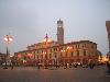
| Forlì FeatureType : null Elevation : 26 Lat/Lng : 44.2333 / 12.05 | Forlì is a comune (municipality) and city in Emilia-Romagna, northern Italy, and is the capital of the province of Forlì-Cesena. It is the central city of Romagna. The city is situated along the Via Emilia, to the right of the Montone river, and is an important agricultural centre (...) |
| 6 | 
| Volgograd FeatureType : null Elevation : 28 Lat/Lng : 48.7 / 44.4996 | Volgograd , formerly Tsaritsyn (ru-Tsaritsyn.ogg), 1589–1925, and Stalingrad , 1925–1961, is an important industrial city and the administrative centre of Volgograd Oblast, Russia. It lies on the western bank of the Volga River (...) |
| 7 | 
| Toluca FeatureType : null Elevation : 2666 Lat/Lng : 19.2922 / -99.6539 | Toluca , officially called Toluca de Lerdo , is the state capital of the State of Mexico as well as the seat of the Municipality of Toluca. It is the center of a rapidly growing urban area, now the fifth largest in Mexico (...) |
| 8 | 
| Senica FeatureType : null Elevation : 209 Lat/Lng : 48.6803 / 17.3664 | Senica is a town in Trnava Region, western Slovakia. It is located in the north-eastern part of the Záhorie lowland, close to the Little Carpathians. (...) |
| 9 | Tovuz District FeatureType : adm1st Elevation : 420 Lat/Lng : 40.9922 / 45.6289 | Tovuz is a rayon of Azerbaijan. It is situated between Shemkir and Agstafa, 360 km from Baku and 107 km from Tbilisi city. A major train line runs through the center, stopping at Tovuz Stansiya. Tovuz also borders Armenia near the village of Alibeyli (...) | |
| 10 | 
| Morelia FeatureType : null Elevation : 1917 Lat/Lng : 19.7008 / -101.1844 | Morelia (; from 1545 to 1828 known as Valladolid) is a city and municipality in the north central part of the state of Michoacán in central Mexico. The city is in the Guayangareo Valley and is the capital and largest city of the state (...) |
| 11 | 
| Roanoke, Virginia FeatureType : city Elevation : 296 Lat/Lng : 37.2708 / -79.9417 | Roanoke is an independent city in the U.S. state of Virginia. At the 2010 census, the population was 97,032. It is located in the Roanoke Valley of the Roanoke Region of Virginia. Roanoke is the largest municipality in Southwest Virginia, and is the principal municipality of the Roanoke Metropolitan (...) |
| 12 | 
| Shusha FeatureType : landmark Elevation : 1364 Lat/Lng : 39.7583 / 46.7483 | Shusha , or Shushi , is a city in the disputed region of Nagorno-Karabakh in the South Caucasus. It has been under the control of the self-proclaimed Artsakh Republic since its capture in 1992 during the Nagorno-Karabakh War (...) |
| 13 | Yarly FeatureType : null Elevation : 257 Lat/Lng : 39.2154 / 48.2829 | Yarly is a village in the Jalilabad Rayon of Azerbaijan. (...) | |
| 14 | Nyasvizh District FeatureType : adm2nd Elevation : 182 Lat/Lng : 53.25 / 26.6667 | Nyasvizh District is a district (rayon) of Minsk Region, Belarus. (...) | |
| 15 | Gadabay District FeatureType : adm1st Elevation : 1397 Lat/Lng : 40.5656 / 45.8161 | Gadabay (; , Gedabek; more common traditional Russian spelling Кедабек, Кедабекский район) is a rayon of Azerbaijan and its administrative center is Gadabay city. The rayon is renowned for its potatoes and its gold fields. (...) | |
| 16 | 
| Allentown, Pennsylvania FeatureType : city Elevation : 119 Lat/Lng : 40.6017 / -75.4772 | Allentown (Pennsylvania Dutch: Allenschteddel) is a city located in Lehigh County, Pennsylvania, United States. It is Pennsylvania's third most populous city and the 231st largest city in the United States. As of the 2010 census, the city had a total population of 118,032 and is currently the (...) |
| 17 | 
| Coventry FeatureType : city Elevation : 95 Lat/Lng : 52.4081 / -1.5106 | Coventry is a city and metropolitan borough in the West Midlands, England. Historically part of Warwickshire, Coventry is the 9th largest city in England and the 12th largest in the United Kingdom.List of English districts by population based on : Coventry is the 9th-largest city in England and the (...) |
| 18 | Rayón, Sonora FeatureType : city Elevation : 563 Lat/Lng : 29.717 / -110.583 | Rayón is a small town surrounded by its municipal area in the center of the Mexican state of Sonora at a distance of 110 kilometers from the state capital Hermosillo. (...) | |
| 19 | Tartar District FeatureType : adm1st Elevation : 237 Lat/Lng : 40.3305 / 46.9429 | Tartar is a rayon of Azerbaijan. Most of it has been under the control of the breakaway Nagorno-Karabakh Republic since the Nagorno-Karabakh War, as part of Martakert Province. IDP's from Nagorno-Karabakh and surrounding occupied regions were moved to Tartar rayon from tent settlements around the (...) | |
| 20 | Dashkasan District FeatureType : adm1st Elevation : 1593 Lat/Lng : 40.5181 / 46.0828 | Dashkasan is a rayon of Azerbaijan. The district was called Dastafur until 1956. The district is located in northwestern Azerbaijan, 33–41 km away from Ganja city and on northeastern edge of Lesser Caucasus rising 1,600-1,800 meters above sea level (...) | |
| 21 | Bilasuvar District FeatureType : adm1st Elevation : 1 Lat/Lng : 39.5 / 48.5 | Bilasuvar - is a rayon of Azerbaijan. Bilasuvar city is its administrative center. (...) | |
| 22 | Kiliya Raion FeatureType : adm2nd Elevation : 15 Lat/Lng : 45.5667 / 29.3333 | Kiliya Rayon is a raion (district) in Odessa Oblast of Ukraine. It is part of the historical region of Bessarabia. Its administrative center is the town of Kiliya. Population: (...) | |
| 23 | Shusha District FeatureType : null Elevation : 1438 Lat/Lng : 39.75 / 46.75 | Shusha (Azerbaijani: Şuşa) is a rayon of Azerbaijan. It surrounds the city of Shusha, in Nagorno-Karabakh, and is completely under control of the unrecognised Republic of Artsakh. (...) | |
| 24 | Sabirabad District FeatureType : adm1st Elevation : -21 Lat/Lng : 39.9167 / 48.6667 | Sabirabad is a rayon of Azerbaijan whose capital which lies at the junction of the Araz and Kura rivers. The low-lying area is dependent on canals and dams whose damage during 2010 caused waters from Lake Sarisu to flood several of the region's villages. (...) | |
| 25 | Jabrayil District FeatureType : adm1st Elevation : 434 Lat/Lng : 39.3333 / 47.0 | Jabrayil (Cəbrayıl) is a rayon of Azerbaijan, occupied by Armenian forces in the Nagorno-Karabakh War. According to the last 1989 Soviet census, there were 49,156 people living in the rayon. Jabrail rayon has productive soils, and before the war the population was mostly involved in agriculture (...) | |
| 26 | 
| Uruapan FeatureType : city Elevation : 1620 Lat/Lng : 19.4112 / -102.0564 | Uruapan is the second largest city in the Mexican state of Michoacán. It is located at the western edge of the Purépecha highlands, just to the east of the Tierra Caliente Region. Since the colonial period, it has been an important city economically due its location (...) |
| 27 | Fuzuli District FeatureType : adm1st Elevation : 423 Lat/Lng : 39.6003 / 47.1431 | Fuzuli or Fizuli is a rayon of Azerbaijan. It was named after the Azerbaijani poet Fuzûlî. Its capital is the town of Füzuli. The western half, including the capital, has been controlled by the breakaway Nagorno-Karabakh, as part of its Hadrut Province, since the Nagorno-Karabakh War (...) | |
| 28 | Ixtlahuaca de Rayón FeatureType : null Elevation : 2528 Lat/Lng : 19.5971 / -99.8086 | Ixtlahuaca de Rayón is a city (often just simply called "Ixtlahuaca") and municipality north of Toluca in the northwest part of the State of Mexico, in Mexico. The distance between Mexico City and Ixtlahuaca is 32 km. The name Ixthahuaca comes from Náhuatl and means plains without trees (...) | |
| 29 | Gülyataq FeatureType : null Elevation : 713 Lat/Lng : 40.1506 / 46.7532 | Gülyataq (also, Gioulatagh, Gyul’yatag, Gyulat’agh, and Vardadzor) is a village in the Tartar Rayon of Azerbaijan. (...) | |
| 30 | Alekseyevka, Khachmaz FeatureType : null Elevation : 1209 Lat/Lng : 41.2922 / 48.3951 | Alekseyevka is a village and municipality in the Khachmaz Rayon of Azerbaijan. It has a population of 1,373. (...) | |
| 31 | Samukh District FeatureType : adm1st Elevation : 199 Lat/Lng : 40.8325 / 46.5097 | Samukh is a rayon of Azerbaijan. The administrative centre, also Samux, was formerly called Nəbiağalı and before that Safaraliyev. (...) | |
| 32 | Khojavend District FeatureType : adm1st Elevation : 387 Lat/Lng : 39.7948 / 47.1132 | Khojavend is a rayon of Azerbaijan. It has been controlled by the breakaway Nagorno-Karabakh Republic since the Nagorno-Karabakh War except easternmost part, with its northeast half as part of Martuni Province and the rest as part of Hadrut Province. (...) | |
| 33 | Znaur District FeatureType : adm1st Elevation : 986 Lat/Lng : 42.25 / 43.75 | Znaur District (Qornisis Raioni; , Znauyry rajon; , Znaurskiy rayon) is one of the districts of South Ossetia. It is located in the southwestern part of South Ossetia. Znauri is the administrative center of the district. (...) | |
| 34 | Absheron District FeatureType : adm1st Elevation : 59 Lat/Lng : 40.4572 / 49.7383 | Absheron Rayon , also spelled as Apsheron, is a rayon of Azerbaijan demarcated in 1963. Although it shares the same name as the Absheron Peninsula, the area covered by the rayon is not conterminous, being further west and mostly inland. (...) | |
| 35 | Lerik District FeatureType : adm1st Elevation : 1165 Lat/Lng : 38.75 / 48.4167 | Lerik Rayon is a rayon located near the Iranian border in southern Azerbaijan, between the tall mountains of the Talysh Mountains and the agricultural plain of the Lankaran Lowland. (...) | |
| 36 | Balakan District FeatureType : adm1st Elevation : 496 Lat/Lng : 41.75 / 46.4167 | Balakan is a rayon of northwestern Azerbaijan, located between Georgia and Russia. It borders Kakheti of Georgia to south and west and Dagestan of Russia to east and north. There is an Azerbaijan-Georgia border crossing at Postbina in the rayon that is open to both local residents and foreigners. (...) | |
| 37 | Imishli District FeatureType : adm1st Elevation : -1 Lat/Lng : 39.8692 / 48.06 | Imishli (İmişli) is a rayon of Azerbaijan. Imishli and neighbouring Sabirabad rayon share Sarysu, the largest lake in Azerbaijan. In August 1930, Qaradonlu was organised on Mil-Mugan historical fields as a region (...) | |
| 38 | Kirovohrad Oblast FeatureType : adm1st Elevation : 159 Lat/Lng : 48.46 / 32.27 | Kirovohrad Oblast (translit. Kirovohrads’ka oblast’; also referred to as Kirovohradschyna -) is an oblast (province) of Ukraine. The administrative center of the oblast is the city of Kropyvnytskyi, formerly known as Kirovohrad. Its population is (...) | |
| 39 | 
| Veraval FeatureType : city Elevation : 10 Lat/Lng : 20.9118 / 70.3686 | Veraval is a municipality and the headquarters of Gir Somnath district in the Indian state of Gujarat. It is 6 km from Somnath. (...) |
| 40 | 
| Ōtake, Hiroshima FeatureType : null Elevation : 5 Lat/Lng : 34.238 / 132.2224 | is a city located in Hiroshima Prefecture, Japan. As of May 1, 2017, the city has an estimated population of 27,684, with 12,939 households, and a population density of 350 persons per km². The total area is 78.57 km². (...) |
| 41 | Tartar (city) FeatureType : null Elevation : 254 Lat/Lng : 40.3418 / 46.9324 | Tərtər (also, Mir Bashir, Mirbäshir, and Terter) is a city in and the capital of the Tartar Rayon of Azerbaijan. (...) | |
| 42 | Qəhrəmanlı, Beylagan FeatureType : null Elevation : 60 Lat/Lng : 39.6987 / 47.691 | Qəhrəmanlı (also Qahramanli, Kagramanli and Kagramanly) is a village and municipality in the Beylagan Rayon of Azerbaijan. It has a population of 2,032. (...) | |
| 43 | Aconchi Municipality FeatureType : null Elevation : 583 Lat/Lng : 29.794 / -110.2203 | Aconchi Municipality is a municipality in Sonora in north-western Mexico. The seat is Aconchi. Neighboring municipalities are Huépac, Cumpas, Ures, Baviácora, Rayón, Banamichi and San Felipe de Jesús. (...) | |
| 44 | Bozalqanlı (Bozalganly) FeatureType : null Elevation : 413 Lat/Lng : 40.9948 / 45.6376 | Bozalqanlı (also, Bozalganly and Bozalkanly) is a village and municipality in the Tovuz Rayon of Azerbaijan. It has a population of 3,861. (...) | |
| 45 | Gədəbəy FeatureType : null Elevation : 1460 Lat/Lng : 40.5706 / 45.8123 | Gədəbəy (also, Gädäbäy, Gadabay, Kedabek, Kedabeko, Kedalek, and Kyadabek) is a city in and capital of the Gadabay Rayon of Azerbaijan. (...) | |
| 46 | Lyuban District FeatureType : adm2nd Elevation : 135 Lat/Lng : 52.7819 / 28.0525 | Lyuban District (Lyubanski rayon, Lyubansky raion) is a district of Minsk Region, Belarus. Its capital is the town of Lyuban. at Minsk Oblispolkom website (...) | |
| 47 | Çöl Ağaməmmədli FeatureType : null Elevation : -21 Lat/Lng : 39.8466 / 48.805 | Çöl Ağaməmmədli (also, Chëlagamamedli, Chël’agamamedli, and Chol’-Aga-Mamedly) is a village and municipality in the Sabirabad Rayon of Azerbaijan. It has a population of 389. (...) | |
| 48 | Yardymli District FeatureType : adm1st Elevation : 1112 Lat/Lng : 38.9206 / 48.2372 | Yardymli is a rayon of Azerbaijan. (...) | |
| 49 | Pruzhany District FeatureType : adm2nd Elevation : 154 Lat/Lng : 52.5588 / 24.4693 | Pruzhany District or Pruzhanski Rayon ; ;) is district (raion) of Brest Region, in Belarus. Its administrative center is Pruzhany. (...) | |
| 50 | Barda District FeatureType : adm1st Elevation : 61 Lat/Lng : 40.3333 / 47.1667 | Barda (Bərdə) is a rayon of Azerbaijan, and its capital city is Barda. There is 1 city and 110 villages in the Rayon, two of which have the same name- Qazaxlar. (...) | |
| 51 | San Miguel de Horcasitas Municipality FeatureType : null Elevation : 386 Lat/Lng : 29.445 / -110.8187 | San Miguel de Horcasitas Municipality is a municipality in Sonora in north-western Mexico. The municipal area is 1,768.45 km2. and the population was 5,626 in 2000. Neighboring municipalities are: Rayón Municipality, in the northeast, Ures Municipality, in the east, Hermosillo Municipality, in the (...) | |
| 52 | Cəlilabad FeatureType : null Elevation : 39 Lat/Lng : 39.2096 / 48.4919 | Cəlilabad (transliterated, Jalilabad) (also, Astrakhanka, Astrakhan-Bazar) is a city in and the capital of the Jalilabad Rayon of Azerbaijan. The city is named after Jalil Mammadguluzadeh. (...) | |
| 53 | Moushkapat FeatureType : city Elevation : 991 Lat/Lng : 39.7714 / 46.9794 | Müşkapat (also Moushkapat and Mushkapat) with a latitude of 39.77(39°46′17 N) and a longitude of 46.98(46°58′6 E), is a populated place located in Khojavend Rayon region of Azerbaijan that is a part of Asia. (...) | |
| 54 | Irshava Raion FeatureType : adm2nd Elevation : 144 Lat/Lng : 48.3202 / 23.0317 | Irshava Raion (Irshavskiy rayon) is a raion (district) in Zakarpattia Oblast of westernmost corner of Ukraine. The only city and the administrative center is Irshava. Irshava Raion is situated on the foothills on the Carpathian Mountains. Population: . (...) | |
| 55 | Agdash District FeatureType : adm1st Elevation : 18 Lat/Lng : 40.5833 / 47.4167 | Agdash is a rayon in central Azerbaijan. The Agdash rayon consists of Leki settlement and 72 villages. This rayon has a favorable economic and geographic location. Turyan River and Kura River along South-West border extend through the territory of the rayon (...) | |
| 56 | Poltava Oblast FeatureType : adm1st Elevation : 78 Lat/Lng : 49.5 / 34.0 | Poltava Oblast (translit. Poltavs’ka oblast’; also referred to as Poltavshchyna –) is an oblast (province) of central Ukraine. The administrative center of the oblast is the city of Poltava. Most of its territory is part of the historic Cossack Hetmanate (its southern regions: Poltava, Myrhorod, (...) | |
| 57 | Kherson Oblast FeatureType : adm1st Elevation : 31 Lat/Lng : 46.5 / 34.0 | Kherson Oblast (translit. Khersons’ka oblast’; also referred to as Khersonshchyna –) is an oblast (province) in southern Ukraine, just north of Crimea. Its administrative center is Kherson. The area of the region is 28,461 km² (...) | |
| 58 | Mykolaiv Oblast FeatureType : adm1st Elevation : 91 Lat/Lng : 47.43 / 31.8 | Mykolaiv Oblast (Mykolajivśka oblasť; also referred to as Mykolaivshchyna), also known as Nikolaev or Nikolayev Oblast (Nikoláyevskaya óblasť), is an oblast (province) of Ukraine. The administrative center of the oblast is the city of Mykolaiv. Population: (...) | |
| 59 | Verden (district) FeatureType : null Elevation : 7 Lat/Lng : 52.97 / 9.18 | Verden is a Kreis (district) in the centre of Lower Saxony, Germany. Adjoining it are (from the northwest clockwise) the districts of Osterholz, Rotenburg, Heidekreis, Nienburg and Diepholz, as well as the city of Bremen. (...) | |
| 60 | Siazan District FeatureType : adm1st Elevation : 183 Lat/Lng : 41.0 / 49.0833 | Siyazan or Siazan is an rayon in Azerbaijan, capital Siyəzən.The word Siyazan means "black female" in Tati.http://www.azerb.com/az-siazan.html?ckattempt=1 The area has population 37,900 (2010 census). (...) | |
| 61 | Qusar District FeatureType : adm1st Elevation : 676 Lat/Lng : 41.4167 / 48.4333 | The District of Qusar is an administrative unit in the northern part of Azerbaijan. It’s administrative center is Qusar city. The district borders upon Quba and Khachmaz rayons of the republic and Dagestan (Russia). A distance from Baku - the capital of Azerbaijan is 180 kilometers. (...) | |
| 62 | Qabala District FeatureType : adm1st Elevation : 553 Lat/Lng : 40.9167 / 47.8333 | Qabala is a rayon of Azerbaijan. Its administrative center is the historic town of Qəbələ, which in ancient times was known as the capital of Caucasian Albania. Gabala Radar Station is in the rayon and was rented by Russia from Azerbaijan. (...) | |
| 63 | Rayón, State of Mexico FeatureType : null Elevation : 2589 Lat/Lng : 19.1389 / -99.577 | Rayón is the municipality located in Toluca Region, the northeastern part of the state of Mexico in Mexico, the municipal seat is Santa María Rayón, formerly named Cuauhtenco. The municipality is located at a southern pass leading out of the Toluca Valley. (...) | |
| 64 | Julfa District FeatureType : adm2nd Elevation : 725 Lat/Lng : 38.96 / 45.63 | Julfa is a rayon of Azerbaijan in the Nakhchivan Autonomous Republic. Its borders upon Armenia in the North-East, and Iran in the South. Its area is 1000 km2. It has a population of 41,195. There are 1 city and 22 villages in the rayon (...) | |
| 65 | Zangilan District FeatureType : null Elevation : 407 Lat/Lng : 39.0833 / 46.6667 | Zangilan Rayon is de jure an administrative territorial entity in the south-western part of the Republic of Azerbaijan, but de facto this territory was occupied by Armenian forces in autumn of 1993, during the Nagorno-Karabakh War and is controlled by the unrecognized Republic of Artsakh till today (...) | |
| 66 | Sumy Oblast FeatureType : adm1st Elevation : 158 Lat/Lng : 51.0 / 34.0 | Sumy Oblast (translit. Sums’ka oblast; also referred to as Sumshchyna –) is an oblast (province) in the northeastern part of Ukraine. The administrative center of the oblast is the city of Sumy. Population: Other important cities within the oblast include Konotop, Okhtyrka, Romny, and Shostka. (...) | |
| 67 | Cherkasy Oblast FeatureType : adm1st Elevation : 109 Lat/Lng : 49.4447 / 32.0603 | Cherkasy Oblast (translit. Cherkas’ka oblast’, ; also referred to as , Cherkashchyna) is an oblast (province) of central Ukraine located along the Dnieper River. The administrative center of the oblast is the city of Cherkasy. Population: (...) | |
| 68 | Kharkiv Oblast FeatureType : adm1st Elevation : 86 Lat/Lng : 49.59 / 36.43 | Kharkiv Oblast (translit. Charkivśka oblastj; also referred to as Kharkivshchyna –) is an oblast (province) in eastern Ukraine. The oblast borders Russia to the north, Luhansk Oblast to the east, Donetsk Oblast to the south-east, Dnipropetrovsk Oblast to the south-west, Poltava Oblast to the west (...) | |
| 69 | Şəlvə, Khojali FeatureType : null Elevation : 965 Lat/Lng : 39.9833 / 46.7667 | Şəlvə is a village in the Khojali Rayon of Azerbaijan. (...) | |
| 70 | Goranboy District FeatureType : adm1st Elevation : 339 Lat/Lng : 40.5833 / 46.6667 | Goranboy is a rayon of Azerbaijan. During the Soviet era the region was best known for the oil-cure sanatorium resort of Naftalan, though administratively Naftalan technically counts as an independent city. Naftalan is now starting to operate again following several years of virtual inaction when (...) | |
| 71 | Opodepe Municipality FeatureType : null Elevation : 974 Lat/Lng : 30.0479 / -110.7654 | Opodepe Municipality is a municipality in Sonora in north-western Mexico. Seat is Opodepe. The municipal area is 2,804.25 km² with a population of 2,842 registered in 2000. (...) | |
| 72 | Rayón, Chiapas FeatureType : null Elevation : 1565 Lat/Lng : 17.2006 / -92.9976 | Rayón is a town and one of the 119 Municipalities of Chiapas, in southern Mexico. As of 2010, the municipality had a total population of 9,002, up from 6,870 as of 2005. It covers an area of 94.4 km². As of 2010, the town of Rayón had a population of 5,895 (...) | |
| 73 | Quzanlı FeatureType : null Elevation : 85 Lat/Lng : 40.1591 / 47.1653 | Quzanlı (also, Kuzanly and Kuzanly Vtoryye) is a village and the most populous municipality in the Ağdam Rayon of Azerbaijan. It has a population of 13,002. The municipality consists of the villages of Quzanlı, Birinci Quzanlı, Eyvazlı, Çullu, and İmamqulubəyli (...) | |
| 74 | Babek District FeatureType : adm2nd Elevation : 986 Lat/Lng : 39.29 / 45.39 | Babek or Babak is a rayon of Azerbaijan in the Nakhchivan Autonomous Republic. It was formerly known as Nakhchivan District (till 1978). The district named in honour of Babak Khorramdin, who led a 23-year-long uprising against the Abbasid Caliphate in Azerbaijan and Iran (...) | |
| 75 | Ujar District FeatureType : adm1st Elevation : 0 Lat/Lng : 40.4167 / 47.75 | Ujar Rayon (Ucar Rayonu"Ucar Rayonu (Approved)" , United States National Geospatial-Intelligence Agency) is a rayon (administrative district) of Azerbaijan, situated to the south of Goycay, 234 km out of Baku, in the centre of the country (...) | |
| 76 | Elizabethton, Tennessee FeatureType : city Elevation : 489 Lat/Lng : 36.3364 / -82.2392 | Elizabethton is a city in, and the county seat of Carter County, Tennessee, United States. Elizabethton is the historical site of the first independent American government (known as the Watauga Association, created in 1772) located west of both the Eastern Continental Divide and the original (...) | |
| 77 | Quba District (Azerbaijan) FeatureType : adm1st Elevation : 660 Lat/Lng : 41.37 / 48.5 | Quba is a rayon in northeastern Azerbaijan. The capital, Quba, is located on the Qudyal River at 41.37°N, 48.50°E. The fertile region surrounding Quba is best known for its production of apples and the city area of Quba is known for its fine carpets. (...) | |
| 78 | Roanne FeatureType : null Elevation : 285 Lat/Lng : 46.0367 / 4.0689 | Roanne (; Rouana in Arpitan) is a commune in the Loire department in central France. It is located northwest of Lyon on the Loire River. It has an important Museum, the , with many Egyptian artifacts. (...) | |
| 79 | Main-Kinzig-Kreis FeatureType : adm2nd Elevation : 135 Lat/Lng : 50.2011 / 9.1975 | Main-Kinzig-Kreis is a Kreis (district) in the east of Hesse, Germany. Neighboring districts are Wetteraukreis, Vogelsbergkreis, Fulda, Bad Kissingen, Main-Spessart, Aschaffenburg, Offenbach and the district-free cities of Offenbach and Frankfurt. (...) | |
| 80 | Frýdek-Místek FeatureType : null Elevation : 318 Lat/Lng : 49.6853 / 18.348 | Frýdek-Místek is a city in Moravian-Silesian Region of the Czech Republic. It is the administrative centre of Frýdek-Místek District. Frýdek-Místek is located at the confluence of two rivers Ostravice and Morávka in the foothills of the Beskyds near the Polish (25 km) and Slovakia (35 km) borders (...) | |
| 81 | Odessa Oblast FeatureType : adm1st Elevation : 100 Lat/Lng : 47.0 / 30.0 | Odessa Oblast (also known as Odesa Oblast; , Odes’ka oblast’, , Odesskaya oblast’) is an oblast (province) of southwestern Ukraine, located along the northern coast of the Black Sea. The oblast consists in the eastern part of the historical region of Novorossiya and the southern part of the (...) | |
| 82 | Rayón FeatureType : null Elevation : 2595 Lat/Lng : 19.1481 / -99.5797 | Rayón may refer to: *Rayón, Chiapas, Mexico *Rayón, State of México, Mexico *Rayón, San Luis Potosí, Mexico *Rayón, Sonora, Mexico | |
| 83 | Oghuz District FeatureType : adm1st Elevation : 670 Lat/Lng : 41.0708 / 47.4583 | Oghuz (Oğuz) is a rayon (administrative division, equivalent of English county) of Azerbaijan. Till 1991, the name of the rayon, established in 1930, was Vartashen . In 2016, it had a population of 43,100. The capital ist Oğuz, also Vartashen until 1991. (...) | |
| 84 | Lələpaşa FeatureType : null Elevation : 227 Lat/Lng : 41.4352 / 46.721 | Lələpaşa (also, Lelapasha and Lyalyapasha) is a village and municipality in the Qakh Rayon of Azerbaijan. It has a population of 464.Qax Rayon İcra Hakimiyyəti: İcra Hakimiyyəti: Bələdiyyələr: (...) | |
| 85 | Güneyçartar FeatureType : null Elevation : 780 Lat/Lng : 39.7565 / 47.0176 | Güneyçartar (also, Gioune-Tchartar, Gyune-Chertaz, and Gyuneychartar) is a village de jure in the Khojavend Rayon of Azerbaijan, de facto in the Martuni Rayon of the Republic of Artsakh. (...) | |
| 86 | Khnushinak FeatureType : null Elevation : 678 Lat/Lng : 39.7657 / 47.0412 | Khnushinak (also, Khnoushinak) is a village in the Khojavend Rayon of Azerbaijan. (...) | |
| 87 | Sərdarkənd FeatureType : null Elevation : 984 Lat/Lng : 39.9896 / 46.7625 | Sərdarkənd (also, Sardaraşen and Sardarashen) is a village in the Khojali Rayon of Azerbaijan. (...) | |
| 88 | Avdur FeatureType : null Elevation : 863 Lat/Lng : 39.8439 / 46.9394 | Avdur (also, Avdour and Avdurr) is a village in the Khojavend Rayon of Azerbaijan. (...) | |
| 89 | Çıldıran FeatureType : city Elevation : 1063 Lat/Lng : 40.1036 / 46.6456 | Çıldıran (also, Ch’ldran and Childyran) is a village in the Kalbajar Rayon of Azerbaijan. (...) | |
| 90 | Tağaser FeatureType : null Elevation : 843 Lat/Lng : 39.5205 / 47.0115 | Tağaser (also T’aghaser and Tagasir) is a village in the Khojavend Rayon of Azerbaijan. (...) | |
| 91 | Pircamal FeatureType : null Elevation : 724 Lat/Lng : 39.9003 / 46.8844 | Pircamal (also, Pirdgamal, Pirdzhamal, and Pirjamal) is a village in the Khojali Rayon of Azerbaijan. (...) | |
| 92 | Alunitdağ FeatureType : null Elevation : 1653 Lat/Lng : 40.5293 / 46.053 | Alunitdağ (also, Aunitdagh) is a village in the Dashkasan Rayon of Azerbaijan. The village forms part of the municipality of Daşkəsən. (...) | |
| 93 | Qarabağlar, Nakhchivan FeatureType : null Elevation : 1173 Lat/Lng : 39.4269 / 45.1977 | Qarabağlar (also, Karabaglar and Karabaglyar) is a village and the most populous municipality in the Kangarli Rayon of Nakhchivan, Azerbaijan. It has a population of 5,833. (...) | |
| 94 | Qovlar FeatureType : null Elevation : 435 Lat/Lng : 40.9419 / 45.7358 | Qovlar (also, Kovlar, Kovlyar, and Koylyar) is a village and the most populous municipality, except for the capital Tovuz, in the Tovuz Rayon of Azerbaijan. It has a population of 13,642. (...) | |
| 95 | Kalva FeatureType : null Elevation : 889 Lat/Lng : 40.7268 / 48.4811 | Kalva (also, Kel’va, Kyal’ve, and Kyalva) is a village and municipality in the Agsu Rayon of Azerbaijan. It has a population of 1,772. (...) | |
| 96 | Ucar, Azerbaijan FeatureType : null Elevation : 18 Lat/Lng : 40.519 / 47.6542 | Ucar (also Udshary, Udzhar, Udzhara, Udzhary and Ujar) is a city and the centre of the Ujar Rayon of Azerbaijan. (...) | |
| 97 | Çinarlı, Qakh FeatureType : null Elevation : 795 Lat/Lng : 41.4697 / 46.9158 | Çinarlı (also, Chinarly) is a village and municipality in the Qakh Rayon of Azerbaijan. It has a population of 415. (...) | |
| 98 | Odzhek FeatureType : null Elevation : 70 Lat/Lng : 40.8167 / 47.0167 | Odzhek is a village in the Yevlakh Rayon of Azerbaijan. It is suspected that this village has undergone a name change or no longer exists, as no Azerbaijani website mentions it under this name. (...) | |
| 99 | Saatlı (city) FeatureType : null Elevation : -10 Lat/Lng : 39.9311 / 48.3697 | Saatlı (also, Saatly and Saotly) is a city in and the capital of the Saatly Rayon of Azerbaijan. (...) | |
| 100 | Siyəzən FeatureType : null Elevation : 51 Lat/Lng : 41.0761 / 49.1139 | Siyəzən (also, Siazan’, Kisil-burun, Kyzyl-Burun) is a city and municipality in, and the capital of, the Siazan Rayon of Azerbaijan. It has a population of 24,900. (...) | |
| 101 | Goranboy (city) FeatureType : null Elevation : 156 Lat/Lng : 40.6103 / 46.7897 | Goranboy (also, Geran’boy, Geranboi, Kasum-Ismailov, Kasum-Ismailovo, Kasum-Izmaylovo, and Qasym Ismayylov) is a city in and the capital of the Goranboy Rayon of Azerbaijan. The municipality consists of the city of Goranboy and the nearby villages of Qarasüleymanlı, Şahməmmədli, Yerevanlı, and (...) | |
| 102 | Ərkivan FeatureType : null Elevation : 17 Lat/Lng : 39.0171 / 48.6431 | Ərkivan (also, Arkivan, Arkavan, Arkesai, Arkevak, Arkevan, and Arkewan) is a village and the most populous municipality in the Masally Rayon of Azerbaijan. With 15,654 inhabitants, Ərkivan is the largest rural community in Azerbaijan.. Aznews.az. 8 December 2014. Retrieved 18 February 2016. (...) | |
| 103 | Goychay (city) FeatureType : null Elevation : 122 Lat/Lng : 40.6506 / 47.7422 | Goychay (also, Göyçay, Gekchai, Geokchai, Geokchay, Geoktschai, Geokčaj, Geychay, and Göychay) is a city and municipality in and the capital of the Goychay Rayon of Azerbaijan. The municipality includes the city of Goychay and the nearby village of Qızılqaya (...) | |
| 104 | Oğuz (city) FeatureType : null Elevation : 652 Lat/Lng : 41.0713 / 47.4653 | Oğuz (transliterated, Oghuz) is a city and municipality in, and the capital of, the Oghuz Rayon of Azerbaijan Republic. The city was known as Vartashen until 1991 and was renamed to Oğuz in 1991. (...) | |
| 105 | Khojaly District FeatureType : city Elevation : 796 Lat/Lng : 39.8333 / 46.75 | Khojali , also called Khojaly, Khodjaly and Hojaly, is a rayon in the Nagorno-Karabakh break away region of Azerbaijan, now under de facto control of the Nagorno-Karabakh Republic. Its capital is Khojali. The region was once a site of prehistoric Khojaly-Gadabay culture (...) | |
| 106 | Khachmaz (city) FeatureType : null Elevation : 47 Lat/Lng : 41.4643 / 48.8057 | Khachmaz is a town in the Khachmaz Rayon of Azerbaijan. (...) | |
| 107 | Astara, Azerbaijan FeatureType : city Elevation : -27 Lat/Lng : 38.4561 / 48.8786 | Astara, also known as Azerbaijani Astara , is a city in and the capital of the Astara Rayon of Azerbaijan. Astara is a short walk across the border from Astara, Iran. (...) | |
| 108 | Nemetsky National District FeatureType : adm2nd Elevation : 141 Lat/Lng : 53.225 / 78.9833 | German National District is an administrativeLaw #28-ZS and municipalLaw #18-ZS district (raion), one of the fifty-nine in Altai Krai, Russia. It is located in the northwest of the krai. The area of the district is . Its administrative center is the rural locality (a selo) of Galbshtadt (...) | |
| 109 | Aeroport District FeatureType : null Elevation : 169 Lat/Lng : 55.7914 / 37.5594 | Aeroport District (rayon Aeroport, "Airport District") is an administrative district (raion) of the Northern Administrative Okrug and one of the 125 raions of Moscow, Russia. The area of the district is . The district is named for the Khodynka Aerodrome, which closed in 2003 (...) | |
| 110 | Altyaghach National Park FeatureType : null Elevation : 941 Lat/Lng : 40.9548 / 48.897 | Altyaghach National Park — is a national park of Azerbaijan. It was established by the decree of the President of Azerbaijan Ilham Aliyev, on an area of in the Khizi Rayon and Siazan Rayon administrative districts on August 31, 2004. (...) | |
| 111 | Zaporizhia Oblast FeatureType : adm1st Elevation : 89 Lat/Lng : 47.8397 / 35.1403 | Zaporizhia Oblast (translit. Zaporiz'ka oblast’;); also referred to as Zaporizhzhya , is an oblast (province) of southern Ukraine. Its capital is Zaporizhia. The oblast covers an area of 27,183 km², and its population was . This oblast is an important part of Ukraine's industry and agriculture. (...) | |
| 112 | Kurdamir District FeatureType : adm1st Elevation : -9 Lat/Lng : 40.25 / 48.1667 | Kurdamir district - administrative and territorial unit in the Republic of Azerbaijan. Founded in 1930 as the center of the Aran economic region. It is located on the Shirvan plain. Kurdamir is bordered by Hajigabul and Sabirabad in the east, Imishli from the south, Zardab, Ujar and Goychay in the (...) | |
| 113 | Lachin District FeatureType : city Elevation : 1087 Lat/Lng : 39.6333 / 46.55 | Lachin is a district in the Republic of Azerbaijan. Its administrative center is Lachin city. This territory was established in 1930 and given the status of a district. It is occupied by the Republic of Artsakh since 1992. (...) | |
| 114 | Rayón, San Luis Potosí FeatureType : null Elevation : 973 Lat/Lng : 21.8433 / -99.6426 | Rayón is a town and municipality in San Luis Potosí in central Mexico. (...) | |
| 115 | Astara District FeatureType : adm1st Elevation : 534 Lat/Lng : 38.5 / 48.6667 | Astara is the southernmost rayon in southeastern Azerbaijan. (...) | |
| 116 | Zardab District FeatureType : adm1st Elevation : -3 Lat/Lng : 40.2183 / 47.7083 | Zardab (Zərdab) is a rayon in Azerbaijan; its capital is Zardab. (...) | |
| 117 | Alleghany County, Virginia FeatureType : adm2nd Elevation : 441 Lat/Lng : 37.78 / -80.01 | Alleghany County is an American county located on the far western edge of Commonwealth of Virginia. It is bordered by the Allegheny Mountains, from which the county derives its name, and it is the northernmost part of the Roanoke Region. The county seat is Covington (...) | |
| 118 | Cerbère FeatureType : null Elevation : 55 Lat/Lng : 42.4442 / 3.1656 | Cerbère (in Catalan: Cervera de la Marenda) is a commune in the Pyrénées-Orientales department in southern France. Its inhabitants are called Cerbériens (Cerverins / Cerverines in Catalan). The village is best known for the border railway station, Gare de Cerbère, on the French side of the border on (...) | |
| 119 | Pirna FeatureType : null Elevation : 116 Lat/Lng : 50.967 / 13.933 | Pirna is a town in the Free State of Saxony, Germany, capital of the administrative district Sächsische Schweiz-Osterzgebirge. The town's population is over 37,000. Pirna is located near Dresden and is an important district town as well as a Große Kreisstadt (...) | |
| 120 | Füzuli FeatureType : null Elevation : 419 Lat/Lng : 39.6009 / 47.1453 | Füzuli (also known as Fizuli, Karjagino, Karyagino, or Sardar), , is a city and the capital of the Füzuli rayon of Azerbaijan. On 23 August 1993, the city fell to Armenian forces during the Nagorno-Karabakh war and since then is administered as part of Hadrut Region of the separatist Nagorno (...) | |
| 121 | Hadrut (town) FeatureType : null Elevation : 733 Lat/Lng : 39.52 / 47.0318 | Hadrut is de facto the administrative center of Hadrut Province, Artsakh and de jure a town in the Khojavend Rayon of Azerbaijan. The town has been de facto part of the Republic of Artsakh (formerly the Nagorno-Karabakh Republic) since the end of the 1991-94 Nagorno-Karabakh War (...) | |
| 122 | Mezquital Valley FeatureType : null Elevation : 1803 Lat/Lng : 20.4527 / -99.2491 | The Mezquital Valley (Nahuatl: Teotlalpan and Otomi: B’ot’ähi) is a series of small valleys and flat areas located in Central Mexico, about north of Mexico City, located in the western part of the state of Hidalgo (...) | |
| 123 | Kura (Caspian Sea) FeatureType : null Elevation : -29 Lat/Lng : 39.3256 / 49.3353 | The Kura (; ; , Mt’k’vari; , Kur; , Cyrus; , Kuruš Allen, William Edward David. , Routledge & Kegan Paul, 1971, p.8. Gachechiladze, Revaz. , TAMU Press, 1996, p.18.) is an east-flowing river south of the Greater Caucasus Mountains which drains the southern slopes of the Greater Caucasus east into (...) | |
| 124 | Nakhchivan (city) FeatureType : null Elevation : 887 Lat/Lng : 39.2089 / 45.4122 | Nakhchivan is the capital of the eponymous Nakhchivan Autonomous Republic of Azerbaijan, located west of Baku. The municipality of Nakhchivan consists of the city of Nakhchivan, the settlement of Əliabad and the villages of Başbaşı, Bulqan, Haciniyyət, Qaraçuq, Qaraxanbəyli, Tumbul, Qarağalıq, and (...) | |
| 125 | Kelsterbach FeatureType : null Elevation : 108 Lat/Lng : 50.0617 / 8.5311 | Kelsterbach is a town in Groß-Gerau district in Hessen, Germany and part of the Frankfurt Rhein-Main urban area. It is located on Frankfurt's southwestern outskirts at a bend on the left bank of the river Main, right where a small brook, called the Kelster (and Bach means "brook") joins the river (...) | |
| 126 | Goygol District FeatureType : adm1st Elevation : 717 Lat/Lng : 40.5833 / 46.3 | Goygol is a rayon (district) in northwestern Azerbaijan. Formerly known as Khanlar, the region was renamed "Goygol" after Lake Goygol, the famous blue lake, by the decision of the Parliament of Azerbaijan on April 25, 2008. The administrative center of the rayon is the city of Goygol. (...) | |
| 127 | Masally District FeatureType : adm1st Elevation : -8 Lat/Lng : 39.0 / 48.6667 | Masally (Masallı) is the administrative area in the south of Azerbaijan. (...) | |
| 128 | Qax (city) FeatureType : null Elevation : 590 Lat/Lng : 41.4183 / 46.9204 | Qakh is the capital of the Qakh Rayon in the north of Azerbaijan, near the Russian border. (...) | |
| 129 | Zaqatala (city) FeatureType : null Elevation : 502 Lat/Lng : 41.6336 / 46.6433 | Zaqatala (; , ; also, Sakataly, Zakatalsk, and Zakataly) is a city in northwest Azerbaijan. With a municipal population of 31,300 inhabitants, it is located northwest of Sheki, by the Tala River and is the main municipality of the Zaqatala rayon (...) | |
| 130 | Parkersburg, West Virginia FeatureType : null Elevation : 199 Lat/Lng : 39.2661 / -81.5422 | Parkersburg is a city in and the county seat of Wood County, West Virginia, United States. Located at the confluence of the Ohio and Little Kanawha rivers, it is the state's third-largest city and the largest city in the Parkersburg-Marietta-Vienna metropolitan area (...) | |
| 131 | Shamkir District FeatureType : adm1st Elevation : 331 Lat/Lng : 40.8333 / 46.0833 | Shamkir is a rayon in Azerbaijan. It is located in the northwestern part of the Azerbaijan Republic. The rayon was previously called "Shamkhor" during the Soviet rule and was renamed to Shamkir only in 1991 after restoration of independence of Azerbaijan. The district was established in 1930 (...) | |
| 132 | Kirən FeatureType : null Elevation : 1405 Lat/Lng : 40.8019 / 45.6214 | Kiran (also, Kiran and Kiran) is a village in the Tovuz Rayon of Azerbaijan. | |
| 133 | Qaratoba FeatureType : null Elevation : 109 Lat/Lng : 41.7142 / 48.5653 | Qaratoba (also, Karatoba) is a village and municipality in the Qusar Rayon of Azerbaijan. It has a population of 637. (...) | |
| 134 | Edilli FeatureType : null Elevation : 715 Lat/Lng : 39.5599 / 47.0692 | Edilli (also, Edillou, Edilu, Edullu, and Iteletsik) is a village in the Khojavend Rayon of Azerbaijan. (...) | |
| 135 | Ağbulaq, Khojaly FeatureType : null Elevation : 786 Lat/Lng : 39.878 / 46.9009 | Ağbulaq (also, Agbulag, Agbulak, Aghboulagh, and Aghbulagh) is a village in the Khojali Rayon of Azerbaijan. (...) | |
| 136 | İsi FeatureType : city Elevation : 100 Lat/Lng : 38.9883 / 48.5834 | İsi is a talysh village and municipality in the Masally Rayon of Azerbaijan. It has a population of 186. (...) | |
| 137 | Ataqut FeatureType : null Elevation : 840 Lat/Lng : 39.5722 / 46.9625 | Ataqut (also, Atagut, Taghout, and Tagot) is a village in the Khojavend Rayon of Azerbaijan. (...) | |
| 138 | Çaylı, Qazakh FeatureType : null Elevation : 402 Lat/Lng : 41.1257 / 45.3107 | Çaylı (also, Chayly) is a village and municipality in the Qazakh Rayon of Azerbaijan. It has a population of 6,878. (...) | |
| 139 | Aşağı Yemişcan FeatureType : null Elevation : 1032 Lat/Lng : 39.7406 / 46.841 | Aşağı Yemişcan (also, Nerkin Syznek and Nerkin-Siznek) is a village in the Khojali Rayon of Azerbaijan. (...) | |
| 140 | Sırxavənd FeatureType : null Elevation : 830 Lat/Lng : 40.0627 / 46.6857 | Sırxavənd (or , also Sarkhavend, Srkhanvend, Srkhavend, Syrkhavend, and Nor Ghazanchi) is a village in the Agdam Rayon of Azerbaijan. (...) | |
| 141 | Zəylik, Tartar FeatureType : null Elevation : 836 Lat/Lng : 40.1698 / 46.5777 | Zəylik (also, Dzaglik, Zagdig, and Zaglik) is a village in the Tartar Rayon of Azerbaijan. (...) | |
| 142 | Alpan, Azerbaijan FeatureType : null Elevation : 760 Lat/Lng : 41.3866 / 48.4301 | Alpan is a village and municipality in the Quba Rayon of Azerbaijan. It has a population of 3,070. | |
| 143 | Abad, Azerbaijan FeatureType : null Elevation : 9 Lat/Lng : 40.4666 / 47.336 | Abad is a village and municipality in the Agdash Rayon of Azerbaijan. It has a population of 1,716. (...) | |
| 144 | Şahmansurlu FeatureType : null Elevation : 1110 Lat/Lng : 40.0604 / 46.5671 | Şahmansurlu (also, Shahmasour, Shahmasur, and Shakhmasur) is a village in the Kalbajar Rayon of Azerbaijan. (...) | |
| 145 | Şuraabad, Agdam FeatureType : null Elevation : -22 Lat/Lng : 40.8194 / 49.4679 | Şuraabad (also, Shuraabad and Shurabad) is a village in the Agdam Rayon of Azerbaijan. (...) | |
| 146 | Yeni Daşkənd FeatureType : null Elevation : 137 Lat/Lng : 40.3847 / 47.0369 | Yeni Daşkənd is a village and municipality in the Barda Rayon of Azerbaijan. It has a population of 2,220. (...) | |
| 147 | Arvana FeatureType : null Elevation : 1758 Lat/Lng : 38.8281 / 48.1204 | Arvana is a village and municipality in the Yardymli Rayon of Azerbaijan. It has a population of 520. (...) | |
| 148 | Kirov, Shusha FeatureType : null Elevation : 1592 Lat/Lng : 39.6372 / 46.6028 | Kirov (Armenian: Հինշեն, Hinshen) (also Koynashen) is a village in the Shusha Rayon of Azerbaijan. (...) | |
| 149 | Kubin FeatureType : city Elevation : 41 Lat/Lng : 38.9074 / 48.6523 | Kubin is a village and municipality in the Masally Rayon of Azerbaijan. It has a population of 509. (...) | |
| 150 | Aşağı Oratağ FeatureType : null Elevation : 597 Lat/Lng : 40.1865 / 46.7805 | Aşağı Oratağ (also, Nerk’in Horrat’agh, Nerkin Horatagh, and Nerkin Oratag) is a village in the Tartar Rayon of Azerbaijan. (...) | |
| 151 | Bazarkand, Karabakh FeatureType : null Elevation : 1052 Lat/Lng : 40.0577 / 46.5835 | Bazarkənd (also, Tsmakahogh and Tsmakaog) is a village in the Kalbajar Rayon of Azerbaijan, currently controlled by NKR. (...) | |
| 152 | Qaratala FeatureType : null Elevation : 249 Lat/Lng : 41.3258 / 46.8719 | Qaratala is a village and municipality in the Qakh Rayon of Azerbaijan. It has a population of 528. (...) | |
| 153 | Qəmərvan FeatureType : null Elevation : 1144 Lat/Lng : 41.061 / 47.7961 | Qəmərvan (also, Kemervan) is a village and municipality in the Qabala Rayon of Azerbaijan. It has a population of 1,839. (...) | |
| 154 | Sos, Artsakh FeatureType : null Elevation : 675 Lat/Lng : 39.7124 / 47.0077 | Sos is a village de jure in the Khojavend Rayon of Azerbaijan, de facto in the Martuni Province of the Republic of Artsakh. (...) | |
| 155 | Sabirli FeatureType : null Elevation : 690 Lat/Lng : 40.5518 / 48.6112 | Sabirli is a village and municipality in the Shamakhi Rayon of Azerbaijan. It has a population of 380. (...) | |
| 156 | Paravatumb FeatureType : null Elevation : 1057 Lat/Lng : 39.8053 / 46.9392 | Paravatumb (also Barabatyn, Paravatoumb, and Parravat’umb) is a village in the Khojavend Rayon of Azerbaijan. (...) | |
| 157 | Çağadüz FeatureType : null Elevation : 895 Lat/Lng : 39.6919 / 46.895 | Çağadüz — is a village in the Khojavend Rayon of Azerbaijan, de facto Republic of Artsakh. (...) | |
| 158 | Dəvədaşı FeatureType : null Elevation : 1017 Lat/Lng : 40.1205 / 46.6162 | Dəvədaşı (also, Poghosagomer, Pogosagomer, and Poqosaqomer) is a village in the Kalbajar Rayon of Azerbaijan. (...) | |
| 159 | Kemrakuch FeatureType : null Elevation : 929 Lat/Lng : 39.5392 / 47.0222 | Kemrakuch (also, Kamrakuch and Kimrakuch) is a village in the Khojavend Rayon of Azerbaijan. (...) | |
| 160 | Astaf FeatureType : null Elevation : 1624 Lat/Lng : 40.4675 / 45.8632 | Astaf is a village and municipality in the Dashkasan Rayon of Azerbaijan. It has a population of 361. (...) | |
| 161 | Əyyublu FeatureType : null Elevation : 368 Lat/Lng : 40.9347 / 45.8261 | Əyyublu (known as Aşağı Ayıblı until 2012) is a village and municipality in the Tovuz Rayon of Azerbaijan. (...) | |
| 162 | Piral FeatureType : null Elevation : 872 Lat/Lng : 41.495 / 48.2857 | Piral is a village and municipality in the Qusar Rayon of Azerbaijan. It has a population of 1,944. (...) | |
| 163 | Topbağ FeatureType : null Elevation : 382 Lat/Lng : 40.8225 / 47.8253 | Topbağ is a village and municipality in the Qabala Rayon of Azerbaijan. It has a population of 513. (...) | |
| 164 | Yextsahoğ FeatureType : null Elevation : 1498 Lat/Lng : 39.6797 / 46.5846 | Yextsahoğ (also, Ieghtsahogh, Yeghtsahogh, Yegtsaog, Yekhtsahogh, and Yekhtsaveg) is a village in the Shusha Rayon of Azerbaijan. (...) | |
| 165 | Cəmiyyət FeatureType : null Elevation : 1058 Lat/Lng : 39.7943 / 46.8862 | Cəmiyyət (also, Ningi, Ninki, Nngi, and Nngui) is a village in the Khojavend Rayon of Azerbaijan, de facto Republic of Artsakh. (...) | |
| 166 | Zərdabi FeatureType : null Elevation : 352 Lat/Lng : 41.3969 / 48.64 | Zərdabi is a village and municipality in the Quba Rayon of Azerbaijan. It has a population of 4,034. (...) | |
| 167 | Qağartsi FeatureType : null Elevation : 878 Lat/Lng : 39.815 / 46.9414 | Qağartsi (Kaghartsi, also, Kagardzi, Kagartsi, Kaghartsi, and Kghartsi) is a village in the Khojavend Rayon of Azerbaijan. (...) | |
| 168 | Əniq FeatureType : null Elevation : 1150 Lat/Lng : 41.3344 / 48.2247 | Əniq (also, Anykh) is a village and municipality in the Qusar Rayon of Azerbaijan. It has a population of 2,129. (...) | |
| 169 | Binə, Khojavend FeatureType : null Elevation : 1102 Lat/Lng : 39.586 / 46.8987 | Binə (Tumi) (also, Domı, Dommy, Domy, and Toumi) is a village in the Khojavend Rayon of Azerbaijan. (...) | |
| 170 | Ukur, Azerbaijan FeatureType : null Elevation : 785 Lat/Lng : 41.4749 / 48.221 | Ukur is a village and municipality in the Qusar Rayon of Azerbaijan. It has a population of 611. (...) | |
| 171 | Ağaverdioba FeatureType : null Elevation : 80 Lat/Lng : 41.6001 / 48.672 | Ağaverdioba is a village and municipality in the Khachmaz Rayon of Azerbaijan. It has a population of 549. (...) | |
| 172 | Şimal FeatureType : null Elevation : -16 Lat/Lng : 41.8025 / 48.6498 | Şimal is a village in the Khachmaz Rayon of Azerbaijan. The village forms part of the municipality of Nabran. (...) | |
| 173 | Abrıx FeatureType : null Elevation : 898 Lat/Lng : 41.037 / 47.7405 | Abrıx is a village and municipality in the Qabala Rayon of Azerbaijan. It has a population of 620. (...) | |
| 174 | Çormanlı FeatureType : null Elevation : 964 Lat/Lng : 40.0307 / 46.5689 | Çormanlı (Garnakhar) (also, Garnakar, Garrnak’ar, and Qarnakar) is a village in the Kalbajar Rayon of Azerbaijan. (...) | |
| 175 | Ərəbsarvan FeatureType : null Elevation : 87 Lat/Lng : 40.5373 / 48.2211 | Ərəbsarvan is a village and municipality in the Agsu Rayon of Azerbaijan. It has a population of 512. (...) | |
| 176 | Zindanmuruqqışlaq FeatureType : null Elevation : 302 Lat/Lng : 41.4896 / 48.5979 | Zindanmuruqqışlaq (also, Zindanmurugkyshlak) is a village and municipality in the Qusar Rayon of Azerbaijan. It has a population of 434. (...) | |
| 177 | Kiçik Qarabəy FeatureType : null Elevation : 760 Lat/Lng : 40.2109 / 46.7547 | Kiçik Qarabəy (also, Möhtätac, Mokhrat’agh, and Mokhratag) is a village in the Tartar Rayon of Azerbaijan. (...) | |
| 178 | Ağabəyyalı FeatureType : null Elevation : 611 Lat/Lng : 40.2125 / 46.7889 | Ağabəyyalı (also, Agabekalendzh, Aghabekalendg, and Aghabekalenj) is a village in the Tartar Rayon of Azerbaijan. (...) | |
| 179 | Yasab FeatureType : null Elevation : 783 Lat/Lng : 41.4926 / 48.3203 | Yasab is a village and municipality in the Qusar Rayon of Azerbaijan. It has a population of 1,838. (...) | |
| 180 | Ağtala FeatureType : null Elevation : 46 Lat/Lng : 41.5384 / 48.7648 | Ağtala (also, Rodnikovka) is a village and municipality in the Khachmaz Rayon of Azerbaijan. It has a population of 377. (...) | |
| 181 | Darğalar FeatureType : null Elevation : 89 Lat/Lng : 40.3361 / 47.1094 | Darğalar is a village and municipality in the Barda Rayon of Azerbaijan. It has a population of 386. (...) | |
| 182 | Muxax FeatureType : null Elevation : 463 Lat/Lng : 41.5707 / 46.7067 | Muxax (also, Muchach and Mukhakh;) is a village and municipality in the Zaqatala Rayon of Azerbaijan. It has a population of 7,236. (...) | |
| 183 | Qumlaq, Jabrayil FeatureType : null Elevation : 278 Lat/Lng : 39.1698 / 46.9232 | Qumlaq (also, Khudap’erin, Kumlak, and Kumlakh) is a village in the Jabrayil Rayon of Azerbaijan. (...) | |
| 184 | Dovşanlı FeatureType : null Elevation : 984 Lat/Lng : 40.0552 / 46.6095 | Dovşanlı (also, Araçadzor, Arachadzor, Aratchadzor, Archadzor, Arrach’adzor, and Arrajadzor) is a village in the Kalbajar Rayon of Azerbaijan. (...) | |
| 185 | Yayıcı FeatureType : null Elevation : 1061 Lat/Lng : 40.1253 / 46.5758 | Yayıcı (also, Kchagot, Kchghot, Kchogut, Kochagot, Kochghut, Kochoghot, Kochogot, Ktchoghout, and Qoçoqot) is a village in the Kalbajar Rayon of Azerbaijan. (...) | |
| 186 | Yasaboba FeatureType : null Elevation : 119 Lat/Lng : 41.6381 / 48.5778 | Yasaboba is a village and municipality in the Qusar Rayon of Azerbaijan. It has a population of 488. (...) | |
| 187 | Ceyranbatan FeatureType : null Elevation : 22 Lat/Lng : 40.5419 / 49.6607 | Ceyranbatan (also, Dzheyranbatan) is a village and municipality in the Absheron Rayon of Azerbaijan. It has a population of 5,969. (...) | |
| 188 | Sarovlu FeatureType : null Elevation : 199 Lat/Lng : 40.7266 / 46.5906 | Sarovlu (also, Sarov and Saroylu) is a village in the Goranboy Rayon of Azerbaijan. The village forms part of the municipality of Dəliməmmədli. (...) | |
| 189 | Yalman FeatureType : null Elevation : 34 Lat/Lng : 40.5732 / 47.7966 | Yalman is a village and municipality in the Goychay Rayon of Azerbaijan. It has a population of 953. (...) | |
| 190 | Amirvan FeatureType : null Elevation : 695 Lat/Lng : 40.8309 / 47.8956 | Amirvan is a village and municipality in the Qabala Rayon of Azerbaijan. It has a population of 1,527. (...) | |
| 191 | Hüsülü, Lachin FeatureType : null Elevation : 1149 Lat/Lng : 39.6424 / 46.4107 | Hüsülü (also, Gyusyulu and Gyusyulyu) is a village in the Lachin Rayon of Azerbaijan. (...) | |
| 192 | Kolatağ FeatureType : city Elevation : 1142 Lat/Lng : 40.0067 / 46.5992 | Kolatak (also, K’olatak and Kolyatag) is a village in the Kalbajar Rayon of Artsakh, formerly known as Nagorno-Karabakh. (...) | |
| 193 | Lerik, Azerbaijan FeatureType : null Elevation : 1103 Lat/Lng : 38.7753 / 48.4153 | Lerik is the capital city of Lerik Rayon in the southern area of Azerbaijan not far from the Iranian border. It is located in the Talysh Mountains, a northwestern subrange of the Alborz (Elburz) mountain range. (...) | |
| 194 | Çatax FeatureType : null Elevation : 1417 Lat/Lng : 40.7262 / 45.5592 | Çatax (also, Çataq and Chatakh) is a village and municipality in the Tovuz Rayon of Azerbaijan. It has a population of 3,189. The municipality consists of the villages of Çatax, Qandalar, Kazımlı, Qoşa, Cirdək, Muncuqlu, Pələkli, Şıxheybət, and Hacılar. (...) | |
| 195 | Binəqədi raion FeatureType : city Elevation : 44 Lat/Lng : 40.466 / 49.8278 | Binəqədi (also, Binagadi, Binagady, Binaghad, and Bonogady) is a settlement, municipality and raion in Baku, Azerbaijan. The rayon has a population of 240,800, of which 112,000 is in the municipality. The raion contains the municipalities of Binəqədi, Biləcəri, M.Ə.Rəsulzadə, and Xocəsən. (...) | |
| 196 | Əliabad, Zaqatala FeatureType : null Elevation : 262 Lat/Lng : 41.4829 / 46.6348 | Əliabad is a village and the most populous municipality, except for the capital Zaqatala, in the Zaqatala Rayon of Azerbaijan. It has a population of 10,700. The majority of population are ethnic Georgians (...) | |
| 197 | Biləsuvar FeatureType : null Elevation : 4 Lat/Lng : 39.4583 / 48.545 | Biləsuvar (transliterated, Bilasuvar; formerly, Pushkino and Pushkin) is a city in and the capital of Bilasuvar Rayon in Azerbaijan. The area's considerable agricultural potential depends on irrigation. The city is located in the Central Aran region (...) | |
| 198 | Yalama FeatureType : null Elevation : 59 Lat/Lng : 41.7594 / 48.5798 | Yalama is a village and municipality in the Khachmaz Rayon of Azerbaijan. It has a population of 4,762. The municipality consists of the villages of Yalama, Düztahiroba, Səlimoba, Ortaoba, Ukuroba, Yaquboba, Zeyxuroba, and Zuxuloba. (...) | |
| 199 | Qirmizi Bazar FeatureType : null Elevation : 670 Lat/Lng : 39.6783 / 46.9488 | Girmizi Bazar (Azerbaijani: Qırmızı Bazar; Armenian: Կարմիր Շուկա, Karmir Shuka or Karmir Shouka, Russian Красный Базар, all meaning "Red Market") is a village in the Khojavend Rayon of the Nagorno-Karabakh region in Azerbaijan (de facto Artsakh Republic). (...) | |
| 200 | Qobustan (town) FeatureType : null Elevation : 796 Lat/Lng : 40.5367 / 48.9328 | Gobustan is a town and municipality in and the administrative center of the Gobustan Rayon of Azerbaijan. It has a population of 3,945. (...) | |
 by
by