| 603 records found in wikipedia | |||
| 1 | 
| Maldives  FeatureType : country Elevation : 8 Lat/Lng : 4.1743 / 73.51 | The Maldives (; Dhivehi Raa'jey), officially the Republic of Maldives, is a South Asian country, located in the Indian Ocean, situated in the Arabian Sea. It lies southwest of Sri Lanka and India. The chain of 26 atolls stretches from Ihavandhippolhu Atoll in the north to the Addu City in the south (...) |
| 2 | 
| Malé FeatureType : city Elevation : 6 Lat/Lng : 4.1748 / 73.5098 | Malé is the capital and most populous city in the Republic of Maldives. With a population of 133,412 and an area of , it is also one of the most densely populated cities in the world. The city is geographically located at the southern edge of North Malé Atoll (Kaafu Atoll) (...) |
| 3 | 
| Minicoy FeatureType : isle Lat/Lng : 8.2833 / 73.0333 | Minicoy, locally known as Maliku (Dhivehi: މަލިކު ;) is an island in Lakshadweep, India. Along with Viringili, it is on Maliku atoll, the southernmost atoll of Lakshadweep archipelago. Administratively, it is a census town in the Indian union territory of Lakshadweep. (...) |
| 4 | 
| Arabian Sea FeatureType : waterbody Lat/Lng : 15.9194 / 63.9061 | The Arabian Sea is a region of the northern Indian Ocean bounded on the north by Pakistan and Iran, on the west by the Gulf of Aden, Guardafui Channel and the Arabian Peninsula, and on the east by India. Its total area is and its maximum depth is (...) |
| 5 | 
| 2004 Indian Ocean earthquake and tsunami FeatureType : event Lat/Lng : 3.316 / 95.854 | The 2004 Indian Ocean earthquake occurred at 00:58:53 UTC on 26 December, with an epicentre off the west coast of northern Sumatra and a magnitude of 9.1–9.3 , reaching a Mercalli intensity up to IX in certain areas (...) |
| 6 | 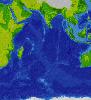
| Indian Ocean FeatureType : waterbody Lat/Lng : -20.0 / 80.0 | The Indian Ocean is the third largest of the world's oceanic divisions, covering (approximately 20% of the water on the Earth's surface). It is bounded by Asia on the north, on the west by Africa, on the east by Australia, and on the south by the Southern Ocean or, depending on definition, by (...) |
| 7 | 
| Thiruvananthapuram FeatureType : null Elevation : 11 Lat/Lng : 8.4874 / 76.952 | Thiruvananthapuram , also known by its former name Trivandrum, is the capital of the Indian state of Kerala. It is the most populous city in Kerala with a population of 957,730 as of 2011. The encompassing urban agglomeration population is around 1.68 million (...) |
| 8 | 
| Galle FeatureType : null Elevation : 17 Lat/Lng : 6.0367 / 80.217 | Galle is a major city in Sri Lanka, situated on the southwestern tip, 119 km from Colombo. Galle is the administrative capital of Southern Province, Sri Lanka and is the district capital of Galle District. Galle was known as Gimhathiththa(although Ibn Batuta in the 14th century refers to it as Qali) (...) |
| 9 | 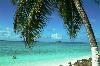
| Diego Garcia FeatureType : isle Elevation : 0 Lat/Lng : -7.3133 / 72.4111 | Diego Garcia is an atoll just south of the equator in the central Indian Ocean, and the largest of 60 small islands comprising the Chagos Archipelago. It was settled by the French in the 1790s and was transferred to British rule after the Napoleonic Wars (...) |
| 10 | 
| Bhutan FeatureType : country Elevation : 2778 Lat/Lng : 27.417 / 90.435 | Bhutan , officially the Kingdom of Bhutan , is a landlocked country in South Asia. Located in the Eastern Himalayas, it is bordered by Tibet Autonomous Region of China in the north, the Sikkim state of India and the Chumbi Valley of Tibet in the west, the Arunachal Pradesh state of India in the (...) |
| 11 | 
| Kanyakumari FeatureType : null Elevation : 47 Lat/Lng : 8.084 / 77.546 | Kanyakumari (Tamil: கன்னியாகுமரி; pronunciation) is a city of Kanyakumari district in the Indian State of Tamil Nadu. Also, called as the "God's own district". The name comes from the Devi Kanya Kumari Temple in the region, in Tamil it is pronounced as 'Kan-niya-kumari' (...) |
| 12 | 
| Bedford FeatureType : null Elevation : 30 Lat/Lng : 52.1337 / -0.4577 | Bedford is the county town of Bedfordshire, England. The town has a population of around 80,000, whereas the Borough of Bedford had a population of 169,912 in mid 2017 together with Kempston. Bedford was founded at a ford on the River Great Ouse, and is thought to have been the burial place of Offa (...) |
| 13 | 
| Djibouti (city) FeatureType : null Elevation : 4 Lat/Lng : 11.5883 / 43.145 | Djibouti City (also called Djibouti;) is the eponymous capital and largest city of Djibouti. It is located in the coastal Djibouti Region on the Gulf of Tadjoura. Djibouti City has a population of around 529,000 inhabitants, which counts for over 70% of the country's population (...) |
| 14 | 
| Anguilla FeatureType : landmark Elevation : 43 Lat/Lng : 18.2272 / -63.049 | Anguilla is a British overseas territory in the Caribbean. It is one of the most northerly of the Leeward Islands in the Lesser Antilles, lying east of Puerto Rico and the Virgin Islands and directly north of Saint Martin (...) |
| 15 | 
| Abbotsford, British Columbia FeatureType : city Elevation : 6 Lat/Lng : 49.0937 / -122.3218 | Abbotsford is a city located in British Columbia, adjacent to the Canada–United States border, Greater Vancouver and the Fraser River. With an estimated population of 141,397 people it is the largest municipality in the province outside Metro Vancouver (...) |
| 16 | Farukolhufushi FeatureType : null Elevation : 7 Lat/Lng : 4.2313 / 73.5444 | null | |
| 17 | 
| India FeatureType : country Elevation : 215 Lat/Lng : 28.6367 / 77.2247 | India (IAST:), also known as the Republic of India (IAST:), is a country in South Asia. It is the seventh-largest country by area, the second-most populous country (with over 1.2 billion people), and the most populous democracy in the world (...) |
| 18 | 
| Sri Lanka FeatureType : country Elevation : 10 Lat/Lng : 6.9 / 79.9 | Sri Lanka (; '; Ilaṅkai), officially the Democratic Socialist Republic of Sri Lanka, is an island country in South Asia, located in the Indian Ocean to the southwest of the Bay of Bengal and to the southeast of the Arabian Sea (...) |
| 19 | 
| Chittagong FeatureType : null Elevation : 37 Lat/Lng : 22.3475 / 91.8123 | Chittagong , officially known as Chattogram, is a major coastal city and financial centre in southeastern Bangladesh. The city has a population of more than 2.5 million while the metropolitan area had a population of 4,009,423 in 2011, making it the second-largest city in the country (...) |
| 20 | 
| Kiribati FeatureType : country Lat/Lng : 1.3272 / 172.9844 | Kiribati , officially the Republic of Kiribati (Gilbertese: Ribaberiki Kiribati),. CIA World Factbook.. Publications.europa.eu. Retrieved on 2016-01-29.. Bbc.com (2013-05-23). Retrieved on 2016-01-29. is a country in Micronesia in the central Pacific Ocean (...) |
| 21 | 
| The Gambia FeatureType : country Lat/Lng : 13.4667 / -16.6 | The Gambia , officially the Republic of The Gambia, is a country in West Africa that is almost entirely surrounded by Senegal with the exception of its western coastline along the Atlantic Ocean. It is the smallest country within mainland Africa.Hoare, Ben (...) |
| 22 | 
| Paracel Islands FeatureType : null Lat/Lng : 16.6667 / 112.3333 | The Paracel Islands, also known as Xisha in Chinese and Hoàng Sa in Vietnamese, is a group of islands, reefs, banks and other maritime features in the South China Sea. It is controlled (and occupied) by the People's Republic of China, and also claimed by Taiwan (Republic of China) and Vietnam (...) |
| 23 | 
| Bangalore FeatureType : city Elevation : 926 Lat/Lng : 12.9779 / 77.5925 | Bangalore , officially known as Bengaluru , is the capital of the Indian state of Karnataka. It has a population of over ten million, making it a megacity and the third most populous city and fifth most populous urban agglomeration in India. It is located in southern India on the Deccan Plateau (...) |
| 24 | Atolls of the Maldives FeatureType : isle Elevation : 8 Lat/Lng : 4.175 / 73.5089 | The Maldives are formed by a number of natural atolls plus atolls in the form of a few islands and isolated reefs today which form a pattern stretching from 7 degrees 10′ North to 0 degrees 45′ South. The Maldives is a long and narrow country formed by 26 natural atolls (...) | |
| 25 | 
| Tuvalu FeatureType : country Elevation : 8 Lat/Lng : -8.5208 / 179.1986 | Tuvalu (or), formerly known as the Ellice Islands, is a Polynesian island country located in the Pacific Ocean, situated in Oceania, about midway between Hawaii and Australia. It lies east-northeast of the Santa Cruz Islands (belonging to the Solomons), southeast of Nauru, south of Kiribati, west of (...) |
| 26 | 
| Bahrain FeatureType : country Elevation : 57 Lat/Lng : 26.0675 / 50.5511 | Bahrain , officially the Kingdom of Bahrain (help=no), is an island country in the Persian Gulf. The sovereign state comprises a small archipelago centered around Bahrain Island, situated between the Qatar peninsula and the north eastern coast of Saudi Arabia, to which it is connected by the King (...) |
| 27 | Addu Atoll FeatureType : null Lat/Lng : -0.6869 / 73.1684 | Addu Atoll, previously also known as Seenu Atoll, is the southernmost atoll of the Maldives. Addu Atoll, together with Fuvahmulah, located 52.3 km north of Addu Atoll, extend the Maldives into the Southern Hemisphere. Addu Atoll is located 541 km south of Malé (...) | |
| 28 | Dhaalu Atoll FeatureType : isle Elevation : 9 Lat/Lng : 3.0033 / 73.0003 | Dhaalu' Atoll (also known as Southern Nilandhe Atoll or Nilandhe Atholhu Dhekunuburi) is one of the atolls of the Maldives. It corresponds to the natural atoll of the same name. (...) | |
| 29 | Velana International Airport FeatureType : null Elevation : 4 Lat/Lng : 4.1918 / 73.5291 | Velana International Airport , also known as Malé International Airport, previously known as Ibrahim Nasir International Airport, is the main international airport in the Maldives. It is located on Hulhulé Island in the North Malé Atoll, nearby the capital island Malé (...) | |
| 30 | 
| Hulhumalé FeatureType : null Lat/Lng : 4.2122 / 73.5404 | Hulhumalé or Hulhulemale (Dhivehi: ހުޅުމާލެ) is a reclaimed island located in the south of North Male Atoll, Maldives. The artificial island was reclaimed to establish a new land mass required to meet the existing and future housing, industrial and commercial development demands of the Malé region (...) |
| 31 | Meemu Atoll FeatureType : adm1st Lat/Lng : 3.0167 / 73.4667 | Mulaku Atoll or Meemu Atoll is an administrative division of the Maldives. It corresponds to the natural atoll of the same name, also known as Mulak Atoll or 'Mulakatolhu'. There is a mosque of historical value in Kolhufushi Island, but no Buddhist remains have been found on this atoll (...) | |
| 32 | Veymandoo FeatureType : null Elevation : 10 Lat/Lng : 2.1877 / 73.0956 | Veymandoo (Dhivehi: ވޭމަންޑޫ) is the capital of Thaa Atoll in the Maldives. (...) | |
| 33 | 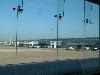
| Bandaranaike International Airport FeatureType : null Elevation : 10 Lat/Lng : 7.1808 / 79.8844 | Bandaranaike International Airport , colloquially known as Katunayake Airport and Colombo International Airport, is the main international airport serving Sri Lanka. It is named after former Prime Minister SWRD Bandaranaike and is located in a suburb of Negombo, 20 miles (32 (...) |
| 34 | Alif Alif Atoll FeatureType : null Lat/Lng : 4.265 / 72.9693 | Alif Alif Atoll (also known as Northern Ari Atoll or Ari Atholhu Uthuruburi) is an administrative division of the Maldives. It was created on March 1, 1984 combining northern section of Ari Atoll, the small Rasdhukuramathi Atoll, and the isolated island of Thoddoo (...) | |
| 35 | 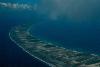
| Rangiroa FeatureType : isle Lat/Lng : -15.125 / -147.6458 | Rangiroa (meaning 'vast sky' in Tuamotuan) or Te Kokōta (Hyades in Māori), is the largest atoll in the Tuamotus, and one of the largest in the world (although it is smaller than Kwajalein in the Marshall Islands and Huvadhu in the Maldives). It is part of the Palliser group (...) |
| 36 | Baa Atoll FeatureType : adm1st Lat/Lng : 5.1333 / 72.95 | Baa Atoll (includes Southern Maalhosmadulu Atoll or Maalhosmadulu Dhekunuburi, Fasdhūtherē Atoll, and Goifulhafehendhu Atoll) is an administrative division of the Maldives. It consists of three separate natural atolls, namely southern Maalhosmadulu Atoll (which is 42 km long and 32 km wide and (...) | |
| 37 | Laccadive Sea FeatureType : waterbody Lat/Lng : 6.3 / 76.533 | The Laccadive Sea or Lakshadweep Sea is a body of water bordering India (including its Lakshadweep islands), the Maldives, and Sri Lanka. It is located to the southwest of Karnataka, to the west of Kerala and to the south of Tamil Nadu (...) | |
| 38 | Kaafu Atoll FeatureType : null Lat/Lng : 4.4167 / 73.5 | Kaafu Atoll is the code name given to an administrative division in the Republic of Maldives which consists of the geographical atolls of Kaashidhoo Island, Gaafaru, North Malé Atoll and South Malé Atoll. As the two Malé Atolls are the main islands of the administrative district, the entire Kaafu (...) | |
| 39 | Gaafu Alif Atoll FeatureType : null Lat/Lng : 0.7292 / 73.331 | Gaafu Alifu (also known as Northern Huvadhu Atoll or Huvadhu Atholhu Uthuruburi) is an administrative division of the Maldives created on February 8, 1962 when Huvadhu Atoll was divided into two districts. Gaafu Alifu corresponds to the northeastern section of this large natural atoll north of the (...) | |
| 40 | Noonu Atoll FeatureType : adm1st Lat/Lng : 5.8333 / 73.3 | Noonu Atoll (also known as Southern Miladhunmadulu Atoll or Miladhunmadulu Dhekunuburi) is an administrative division of the Maldives corresponding to the southern section of Miladhunmadulu Atoll. The capital is Manadhoo. Total population of Noonu Atoll is around 10 (...) | |
| 41 | 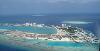
| Thilafushi FeatureType : null Lat/Lng : 4.1833 / 73.4333 | Thilafushi is an artificial island created as a municipal landfill situated to the west of Malé, and is located between Kaafu Atoll's Giraavaru and Gulhifalhu of the Maldives. (...) |
| 42 | Indian subcontinent FeatureType : null Elevation : 325 Lat/Lng : 20.0 / 78.0 | The Indian subcontinent is a southern region and peninsula of Asia, mostly situated on the Indian Plate and projecting southwards into the Indian Ocean from the Himalayas. Geologically, the Indian subcontinent is related to the land mass that rifted from Gondwana and merged with the Eurasian plate (...) | |
| 43 | Vaavu Atoll FeatureType : adm1st Elevation : 8 Lat/Lng : 3.4719 / 73.5469 | Vaavu Atoll is an administrative division of the Maldives comprising the natural atolls of Felidhu Atoll and the Vattaru Reef. It is the smallest administrative atoll in terms of population. This atoll is located 40 miles from capital Malé, 60 minutes by speedboat and 3 hours by dhoni (...) | |
| 44 | Laamu Atoll FeatureType : adm1st Lat/Lng : 1.9333 / 73.4167 | Laamu Atoll (also known as Haddhunmathi Atoll) is an administrative division of the Maldives. It corresponds to the natural atoll of the same name. The administrative capital is located in Fonadhoo Island. (...) | |
| 45 | Haa Alif Atoll FeatureType : null Lat/Lng : 6.88 / 73.1122 | Haa Alif Atoll is the code name based on the letters of the Maldivian alphabet commonly used to refer to the administrative division officially known as North Thiladhunmathi Atoll (Maldivian: Thiladhunmathi Uthuruburi) in the Maldives (...) | |
| 46 | 2016 AFC Champions League FeatureType : null Elevation : 385 Lat/Lng : 38.8383 / 65.8139 | The 2016 AFC Champions League was the 35th edition of Asia's premier club football tournament organized by the Asian Football Confederation (AFC), and the 14th under the current AFC Champions League title. Jeonbuk Hyundai Motors defeated Al-Ain in the final to win their second AFC Champions League (...) | |
| 47 | 
| Phuntsholing FeatureType : city Elevation : 218 Lat/Lng : 26.85 / 89.3833 | Phuntsholing, also spelled as Phuentsholing is a border town in southern Bhutan and is the administrative seat of Chukha District. The town occupies parts of both Phuentsholing Gewog and Sampheling Gewog. Phuentsholing adjoins the Indian town of Jaigaon, and cross-border trade has resulted in a (...) |
| 48 | Fuvahmulah FeatureType : null Elevation : 9 Lat/Lng : -0.2988 / 73.424 | Fuvahmulah City (Dhivehi: ފުވައްމުލައް) is an island (atoll) in the Maldives. It is under Maldives administrative divisions of Gnaviyani Atoll or Nyaviyani Atoll. The inhabitants speak a distinctive form of the Dhivehi language, known as "dhivehi bas" (...) | |
| 49 | South Asia FeatureType : country Elevation : 249 Lat/Lng : 26.9 / 72.2 | South Asia or Southern Asia, is a term used to represent the southern region of the Asian continent, which comprises the sub-Himalayan SAARC countries and, for some authorities, adjoining countries to the west and east (...) | |
| 50 | Gaafu Dhaalu Atoll FeatureType : adm1st Lat/Lng : 0.3831 / 73.2211 | Gaafu Dhaalu (also known as Southern Huvadhu Atoll or Huvadhu Atholhu Dhekunuburi) is an administrative district of the Maldives formed by the southwestern section of Huvadhu Atoll. It was created on February 8, 1962 when Huvadhu Atoll was divided into two districts (...) | |
| 51 | Dhonfanu FeatureType : null Elevation : 10 Lat/Lng : 5.1879 / 73.1234 | Dhonfanu (Dhivehi: ދޮންފަނު) is one of the inhabited islands of Baa Atoll in the Maldives. (...) | |
| 52 | Lakshadweep FeatureType : adm1st Lat/Lng : 10.57 / 72.63 | Lakshadweep (Hindi लक्षद्वीप, , Lakṣadvīp, Lakshadīb), formerly known as the Laccadive, Minicoy, and Aminidivi Islands , is a group of islands in the Laccadive Sea, off the southwestern coast of India. The archipelago is a Union Territory and is governed by the Union Government of India (...) | |
| 53 | Al-Azhar University FeatureType : edu Elevation : 32 Lat/Lng : 30.0458 / 31.2625 | Al-Azhar University (; , , "the (honorable) University of Al-Azhar") is a university in Cairo, Egypt. Associated with Al-Azhar Mosque in Islamic Cairo, it is Egypt's oldest degree-granting university and is renowned as "Sunni Islam’s most prestigious university" (...) | |
| 54 | Chagos Archipelago FeatureType : null Lat/Lng : -5.3333 / 71.85 | The Chagos Archipelago or Chagos Islands (formerly the Bassas de Chagas, and later the Oil Islands) are a group of seven atolls comprising more than 60 individual tropical islands in the Indian Ocean about 500 kilometres (310 mi) south of the Maldives archipelago (...) | |
| 55 | Kulhudhuffushi FeatureType : null Elevation : 6 Lat/Lng : 6.6221 / 73.07 | Kulhudhuffushi (Dhivehi) is the capital of Haa Dhaalu Atoll administrative division on Thiladhunmathi Atoll in the north of the Maldives. Kulhudhuffushi is known as the "Heart of the North". The island is famous for its mangroves (kulhi), after which the island itself is named. (...) | |
| 56 | 2014 AFC Challenge Cup FeatureType : null Elevation : 8 Lat/Lng : 4.1753 / 73.5089 | The 2014 AFC Challenge Cup was the fifth and the final edition of the AFC Challenge Cup, an international football competition for Asian Football Confederation (AFC) member nations that are mainly categorized as "emerging countries" in the now defunct Vision Asia programme (...) | |
| 57 | 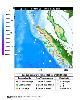
| 2005 Nias–Simeulue earthquake FeatureType : event Lat/Lng : 2.0931 / 97.0161 | The 2005 Nias–Simeulue earthquake occurred on 28 March off the west coast of northern Sumatra, Indonesia. At least 915 people were killed, mostly on the island of Nias. The event caused panic in the region, which had already been devastated by the massive tsunami triggered by the 2004 Indian Ocean (...) |
| 58 | 2017 AFC Champions League FeatureType : null Elevation : 1271 Lat/Lng : 35.7244 / 51.2756 | The 2017 AFC Champions League was the 36th edition of Asia's premier club football tournament organized by the Asian Football Confederation (AFC), and the 15th under the current AFC Champions League title. Urawa Red Diamonds defeated Al-Hilal in the final to win their second AFC Champions League (...) | |
| 59 | Ibn Battuta FeatureType : null Elevation : 3 Lat/Lng : 22.3308 / 36.4903 | Ibn Battuta (; ; fully ; Arabic:) (February 25, 13041368 or 1369) was a Berber Muslim Moroccan scholar and explorer who widely travelled the medieval world. After outlining the extensive route of Ibn Battuta's Journey, Nehru notes: "This is a record of travel which is rare enough today with our many (...) | |
| 60 | Alif Dhaal Atoll FeatureType : null Lat/Lng : 3.6561 / 72.8203 | Alifu Dhaalu Atoll (also known as Southern Ari Atoll or Ari Atholhu Dhekunuburi) is an administrative division of the Maldives. The separation of Ari Atoll (formerly Alifu Atoll) on March 1, 1984, into a Northern and a Southern section formed the two most recent administrative divisions of the (...) | |
| 61 | Gan International Airport FeatureType : null Elevation : 1 Lat/Lng : -0.6933 / 73.1556 | Gan International Airport is located on the island of Gan in Addu Atoll (previously known as Seenu Atoll) in the Maldives. (...) | |
| 62 | Faafu Atoll FeatureType : adm1st Lat/Lng : 3.2333 / 72.9333 | Faafu Atoll (also known as Northern Nilandhe Atoll or Nilandhe Atholhu Uthuruburi) is an administrative division of the Maldives. It corresponds to the natural atoll of the same name. Certain islands of this atoll used to be inhabited, like Himithi (...) | |
| 63 | 2016 AFC Cup FeatureType : null Elevation : 592 Lat/Lng : 32.0833 / 36.1 | The 2016 AFC Cup was the 13th edition of the AFC Cup, Asia's secondary club football tournament organized by the Asian Football Confederation (AFC). Al-Quwa Al-Jawiya defeated Bengaluru FC in the final to win their first AFC Cup title, becoming the first Iraqi team to win the competition (...) | |
| 64 | Thimarafushi Airport FeatureType : null Elevation : 3 Lat/Lng : 2.2083 / 73.1478 | Thimarafushi Airport is a domestic airport located on the island of Thimarafushi in Thaa Atoll, Maldives. Built by the Maldives Transport and Contracting Company (MTCC) a test flight landed at the airport successfully on 2 September 2013 (...) | |
| 65 | Felidhoo (Vaavu Atoll) FeatureType : null Elevation : 8 Lat/Lng : 3.4718 / 73.547 | Felidhoo (Dhivehi: ފެލިދޫ) is one of the inhabited islands of Vaavu Atoll in the Maldives. (...) | |
| 66 | Addu Football Stadium FeatureType : null Elevation : 3 Lat/Lng : -0.6158 / 73.0968 | The Addu Football Stadium is a sporting stadium in Addu City, Maldives. The stadium went through renovations in 2014 for the hosting of some matches of the 2014 AFC Challenge Cup.; Sun Online, January 15, 2014; Miadhu Daily, January 13, 2014 (...) | |
| 67 | Rangali FeatureType : null Elevation : 7 Lat/Lng : 3.6157 / 72.7176 | Rangali is an island in Alif Dhaal Atoll, Maldives. It is the setting for the Conrad Maldives Rangali Island resort, which has twice been voted the best hotel in the world. It is known for its underwater restaurant Ithaa.Mr. Simplicity.(2007_04). . Fun Distraction. Retrieved on 2012-04-02. (...) | |
| 68 | 
| Farquhar Group FeatureType : isle Lat/Lng : -10.1667 / 51.1667 | The Farquhar Group belong to the Outer Islands of the Seychelles, lying in the southwest of the island nation, more than southwest of the capital, Victoria, on Mahé Island. (...) |
| 69 | Southern Hemisphere FeatureType : null Lat/Lng : -45.0 / 0.0 | The Southern Hemisphere is the half of Earth that is south of the Equator. It contains all or parts of five continents (Antarctica, Australia, about 90% of South America, the southern third of Africa, and several southern islands off the continental mainland of Asia), four oceans (Indian, South (...) | |
| 70 | Asian Games FeatureType : null Elevation : 220 Lat/Lng : 28.637 / 77.2144 | The Asian Games, also known as Asiad, is a continental multi-sport event held every four years among athletes from all over Asia. The Games were regulated by the Asian Games Federation (AGF) from the first Games in New Delhi, India, until the 1978 Games (...) | |
| 71 | Maldive Islands FeatureType : null Lat/Lng : 3.2 / 73.22 | The Maldives Islands is a group of islands in the Indian Ocean composing today's Republic of Maldives and the island of Minicoy in the Union Territory of Lakshadweep of India. Historically Minicoy was within the domain of the sultans of the Maldives (...) | |
| 72 | Gan (Huvadhu Atoll) FeatureType : null Elevation : 10 Lat/Lng : 0.2772 / 73.4328 | Gan is one of the uninhabited islands of Southern Huvadhu Atoll, in the Gaafu Dhaalu Atoll administrative division of the Maldives. Gan Island was formerly inhabited, but its inhabitants moved to neighboring islands after a severe epidemic at the end of the 18th century (...) | |
| 73 | 
| Thimarafushi (Thaa Atoll) FeatureType : null Elevation : 9 Lat/Lng : 2.2044 / 73.1432 | The island of Thimarafushi (Dhivehi: ތިމަރަފުށި), (pronounced "thi-ma-ra-fu-shi") is one of the inhabited islands of the Maldives. (...) |
| 74 | Raa Atoll FeatureType : adm1st Lat/Lng : 5.7635 / 72.985 | Raa Atoll (also known as Northern Maalhosmadulu Atoll or Maalhosmadulu Uthuruburi) is an administrative division from the Maldives. The capital is Ungoofaaru. It includes Northern Maalhosmadulu Atoll proper and the island of Alifushi. 1 (...) | |
| 75 | Geography of the Maldives FeatureType : null Lat/Lng : 3.25 / 73.0 | Maldives is a country of South Asia, situated in the Indian Ocean, south-southwest of India. It consists of approximately 1,190 coral islands grouped in a double chain of 26 atolls, spread over roughly 90,000 square kilometers, making this one of the most disparate countries in the world (...) | |
| 76 | US Open (tennis) FeatureType : landmark Elevation : 14 Lat/Lng : 40.7499 / -73.847 | The United States Open Tennis Championships is a hard court tennis tournament. The tournament is the modern version of one of the oldest tennis championships in the world, the U.S. National Championship, for which men's singles was first played in 1881 (...) | |
| 77 | Expo 2015 FeatureType : event Elevation : 140 Lat/Lng : 45.5187 / 9.1067 | Expo 2015 was a universal exposition hosted by Milan, Italy. It opened on May 1 at 10:00 CEST and closed on October 31. Milan hosted an exposition for the second time; the first was the 1906 Milan International (...) | |
| 78 | Kurinbi (Haa Dhaalu Atoll) FeatureType : null Elevation : 11 Lat/Lng : 6.6667 / 72.9956 | Kurinbi (Dhivehi: ކުރިނބީ) is one of the inhabited islands of Haa Dhaalu Atoll administrative division and geographically part of Thiladhummathi Atoll in the north of the Maldives. (...) | |
| 79 | Funadhoo (Shaviyani Atoll) FeatureType : null Elevation : 6 Lat/Lng : 6.1483 / 73.29 | Funadhoo (Dhivehi: ފުނަދޫ) is one of the inhabited islands of the Shaviyani Atoll administrative division and geographically part of the Miladhummadulhu Atoll in the Maldives. (...) | |
| 80 | Hanimaadhoo International Airport FeatureType : null Elevation : 3 Lat/Lng : 6.7457 / 73.1693 | Hanimaadhoo International Airport is an airport located on the island of Hanimaadhoo from DAFIF (effective October 2006) in Haa Dhaalu Atoll, Maldives, opened as a domestic airport. It was upgraded to an international airport on 2 February 2012, with the introduction of direct flights to (...) | |
| 81 | Zheng He FeatureType : null Elevation : 50 Lat/Lng : 31.9103 / 118.7286 | Zheng He (; 1371–1433 or 1435) was a Chinese mariner, explorer, diplomat, fleet admiral, and court eunuch during China's early Ming dynasty. He was originally born as Ma He in a Muslim family, later adopted the conferred surname Zheng from Emperor Yongle.Dreyer 2007, 22–23 (...) | |
| 82 | Narudhoo (Shaviyani Atoll) FeatureType : null Lat/Lng : 6.2633 / 73.2147 | Narudhoo (Dhivehi: ނަރުދޫ) is one of the inhabited islands of the Shaviyani Atoll administrative division and geographically part of the Miladhummadulhu Atoll in the Maldives. (...) | |
| 83 | Dhaandhoo FeatureType : null Elevation : 7 Lat/Lng : 0.6197 / 73.4639 | Dhaandhoo (Dhivehi: ދާންދޫ) is one of the inhabited islands of Gaafu Alif Atoll in the Maldives. (...) | |
| 84 | Maaungoodhoo (Shaviyani Atoll) FeatureType : null Elevation : 10 Lat/Lng : 6.0377 / 73.2846 | Maaungoodhoo (Dhivehi: މާއުނގޫދޫ) is one of the inhabited islands of the Shaviyani Atoll administrative division and geographically part of the Miladhummadulhu Atoll in the Maldives. (...) | |
| 85 | Hulhudheli (Dhaalu Atoll) FeatureType : null Elevation : 9 Lat/Lng : 2.8583 / 72.8486 | Hulhudheli (Dhivehi: ހުޅުދެލި) is one of the inhabited islands of Dhaalu Atoll. People of Hulhudheli are among the most skilled silversmith in the maldives. (...) | |
| 86 | Magoodhoo (Faafu Atoll) FeatureType : null Elevation : 10 Lat/Lng : 3.0778 / 72.9653 | Magoodhoo (Dhivehi: މަގޫދޫ) is one of the inhabited islands of Faafu Atoll in the Maldives. (...) | |
| 87 | Nolhivaranfaru FeatureType : null Elevation : 5 Lat/Lng : 6.7018 / 73.1185 | Nolhivaranfaru (Dhivehi: ނޮޅިވަރަންފަރު) is one of the inhabited islands of Haa Dhaalu Atoll administrative division and geographically part of Thiladhummathi Atoll in the north of the Maldives. (...) | |
| 88 | Commonwealth of Nations FeatureType : null Elevation : 19 Lat/Lng : 51.505 / -0.1358 | The Commonwealth of Nations, normally known as the Commonwealth, is an intergovernmental organisation of 53 member states that are mostly former territories of the British Empire. The chief institutions of the organisation are the Commonwealth Secretariat, which focuses on intergovernmental aspects, (...) | |
| 89 | Kelantan FA FeatureType : landmark Elevation : 10 Lat/Lng : 6.1239 / 102.2433 | Kelantan Football Association , also well known as The Red Warriors is a professional football association based in Kota Bharu, in the Malaysian state of Kelantan. The football team has played in the top tier of Malaysian football, Malaysia Super League since 2009 (...) | |
| 90 | Holy See FeatureType : city Elevation : 47 Lat/Lng : 41.9033 / 12.4533 | The Holy See , also called the See of Rome, is the apostolic episcopal see of the bishop of Rome, known as the Pope, ex cathedra the universal ecclesiastical jurisdiction of the worldwide Catholic Church, and a sovereign entity of international law (...) | |
| 91 | University of Bath FeatureType : edu Elevation : 191 Lat/Lng : 51.3796 / -2.328 | The University of Bath is a public university located in Bath, Somerset, United Kingdom. It received its royal charter in 1966, along with a number of other institutions following the Robbins Report. Like the University of Bristol and University of the West of England, Bath can trace its roots to (...) | |
| 92 | UiTM Stadium FeatureType : landmark Elevation : 9 Lat/Lng : 2.2027 / 102.2454 | Stadium UiTM is a small stadium located at Shah Alam, Malaysia. Its capacity is 10,000. The stadium was built for Universiti Teknologi MARA and the UiTM Football Club. SPA FC is the other tenant that also uses the stadium. It is sometimes used for football matches from the local team (...) | |
| 93 | Hyder Ali FeatureType : null Elevation : 683 Lat/Lng : 12.41 / 76.7139 | Hyder Ali Khan, Haidarālī (c. 1720 – 7 December 1782) was the Sultan and de facto ruler of the Kingdom of Mysore in southern India. Born as Sayyid wal Sharif Hyder Ali Khan, he distinguished himself militarily, eventually drawing the attention of Mysore's rulers (...) | |
| 94 | Hulhulé Island FeatureType : null Elevation : 3 Lat/Lng : 4.1866 / 73.5268 | Hulhulé , located at , is an island in the North Malé Atoll of the Maldives where the city's airport, Velana International Airport, is located. The island has no permanent population., Isles website, official Maldives government website It is one of the islands closest to the capital island Malé (...) | |
| 95 | Football at the 2018 Asian Games FeatureType : null Elevation : 17 Lat/Lng : -6.2333 / 107.0 | Football at the 2018 Asian Games was held from 14 August to 1 September 2018 in Indonesia. One of the host cities, Palembang, hosted the women's event, while the men's matches are played in Bekasi, Cibinong, Cikarang, and Soreang (...) | |
| 96 | Fuvahmulah Airport FeatureType : null Elevation : 5 Lat/Lng : -0.3094 / 73.4325 | Fuvahmulah Airport is a domestic airport located on the island of Fuvahmulah (also known as Fuvahmulaku) in Gnaviyani Atoll, Maldives. It was opened in November 2011. (...) | |
| 97 | Dharavandhoo Airport FeatureType : null Elevation : 11 Lat/Lng : 5.1569 / 73.1302 | Dharavandhoo Airport is a domestic airport located on the island of Dharavandhoo, part of the Baa Atoll in Maldives. It was opened on 17 October 2012 by President Mohamed Waheed Hassan. Flight operations began to the airport on 15 October 2012. (...) | |
| 98 | Vonmuli FeatureType : null Elevation : 14 Lat/Lng : 2.9115 / 72.8661 | Vommuli Island is an uninhabited island in the Maldives. It is located near a coral reef and has a sandy beach, with thick palm tree vegetation in its interior. The island is owned by Vermilion International, a company based in the Maldives. (...) | |
| 99 | Southern Maalhosmadulu Atoll FeatureType : null Lat/Lng : 5.1667 / 73.0 | Southern Maalhosmadulu Atoll (code name Baa) is an administrative division of the Maldives. It consists of two separate natural atolls, namely the southern part of Maalhosmadulhu Atoll (which is 42 km long and 32 km wide and consists of 10 inhabited islands) and the smaller natural atoll known as (...) | |
| 100 | UNESCO FeatureType : landmark Elevation : 35 Lat/Lng : 48.8501 / 2.3062 | The United Nations Educational, Scientific and Cultural Organization (UNESCO;) is a specialized agency of the United Nations (UN) based in Paris. Its declared purpose is to contribute to peace and security by promoting international collaboration through educational, scientific, and cultural reforms (...) | |
| 101 | Extreme points of Earth FeatureType : null Lat/Lng : -80.0 / -115.0 | This is a list of extreme points of Earth, the geographical locations that are farther north or south than, higher or lower in elevation than, or farthest inland or out to sea from, any other locations on the landmasses, continents or countries (...) | |
| 102 | Uppsala University FeatureType : landmark Elevation : 37 Lat/Lng : 59.8575 / 17.6289 | Uppsala University is a research university in Uppsala, Sweden, and is the oldest university in Sweden and all of the Nordic countries still in operation, founded in 1477.Ridder-Symoens, Hilde de. A History of the University in Europe. Cambridge University Press, 2003. Page 84 (...) | |
| 103 | Commonwealth Games FeatureType : null Elevation : 22 Lat/Lng : 51.5072 / -0.1275 | The Commonwealth Games are an international multi-sport event involving athletes from the Commonwealth of Nations. The event was first held in 1930, and has taken place every four years since then. The Commonwealth Games were known as the British Empire Games from 1930 to 1950, the British Empire (...) | |
| 104 | A-League FeatureType : null Elevation : 21 Lat/Lng : -34.91 / 138.57 | The A-League is a professional men's soccer league run by Football Federation Australia (FFA). At the top of the Australian league system, it is the country's primary competition for the sport. The A-League was established in 2004 as a successor to the National Soccer League (NSL) and competition (...) | |
| 105 | 2016 FeatureType : null Elevation : 25 Lat/Lng : 30.6004 / 114.6192 | 2016 was designated as: * International Year of Pulses by the sixty-eighth session of the United Nations General Assembly. * International Year of Global Understanding (IYGU) by the International Council for Science (ICSU), the International Social Science Council (ISSC), and the International (...) | |
| 106 | Atoll FeatureType : null Lat/Lng : -5.27 / 159.35 | An atoll (or),pronunciation in old video on youtube, sometimes called a coral atoll, is a ring-shaped coral reef including a coral rim that encircles a lagoon partially or completely. There may be coral islands or cays on the rim (...) | |
| 107 | Funadhoo FeatureType : null Elevation : 10 Lat/Lng : 5.2744 / 73.0332 | Funadhoo as a place name may refer to: * Funadhoo (Baa Atoll) (Republic of Maldives) * Funadhoo (Kaafu Atoll) (Republic of Maldives) * Funadhoo (Shaviyani Atoll) (Republic of Maldives) | |
| 108 | 2010 Polish Air Force Tu-154 crash FeatureType : landmark Elevation : 257 Lat/Lng : 54.8239 / 32.0513 | On 10 April 2010, a Tupolev Tu-154 aircraft of the Polish Air Force crashed near the city of Smolensk, Russia, killing all 96 people on board. Among the victims were the President of Poland Lech Kaczyński and his wife Maria, the former President of Poland in exile Ryszard Kaczorowski, the chief of (...) | |
| 109 | International Red Cross and Red Crescent Movement FeatureType : landmark Elevation : 443 Lat/Lng : 46.2277 / 6.1371 | The International Red Cross and Red Crescent Movement is an international humanitarian movement with approximately 17 million volunteers, members and staff worldwide which was founded to protect human life and health, to ensure respect for all human beings, and to prevent and alleviate human (...) | |
| 110 | Aung San Suu Kyi FeatureType : null Elevation : 28 Lat/Lng : 16.8256 / 96.1503 | Aung San Suu Kyi (; ; born 19 June 1945) is a Burmese politician, diplomat, author, and Nobel Peace Prize laureate (1991). She is the leader of the National League for Democracy and the first and incumbent State Counsellor, a position akin to a prime minister (...) | |
| 111 | 2012 Indian Ocean earthquakes FeatureType : event Lat/Lng : 2.311 / 93.063 | The 2012 Indian Ocean earthquakes were magnitude 8.6 and 8.2 Mw undersea earthquakes that struck near the Indonesian province of Aceh on 11 April at 15:38 local time. Initially, authorities feared that the initial earthquake would cause a tsunami and warnings were issued across the Indian Ocean; (...) | |
| 112 | Maavaidhoo (Haa Dhaalu Atoll) FeatureType : null Elevation : 6 Lat/Lng : 6.5153 / 73.0511 | Maavaidhoo (Dhivehi: މާވައިދޫ) is one of the inhabited islands of Haa Dhaalu Atoll administrative division and geographically part of Thiladhummathi Atoll in the north of the Maldives. The island was severely damaged by the great cyclone of 1821 that hit the northern atolls of the Maldives. | |
| 113 | Machchafushi FeatureType : null Elevation : 8 Lat/Lng : 3.5936 / 72.8835 | Machchafushi is one of the uninhabited islands of Alif Dhaal Atoll, Maldives. It is the setting for the Centara Grand Island Resort & Spa Maldives resort, which is one of the 11 5-star properties run by Centara Hotels and Resorts. (...) | |
| 114 | Kudahuvadhoo FeatureType : null Elevation : 8 Lat/Lng : 2.6717 / 72.8937 | Kudahuvadhoo (Dhivehi: ކުޑަހުވަދޫ) is one of the inhabited islands of Dhaalu or South Nilande Atoll in the Maldives. (...) | |
| 115 | Kasaragod district FeatureType : null Elevation : 22 Lat/Lng : 12.4925 / 74.9906 | Kasaragod District is one of the 14th districts in the state of Kerala, India. Kasaragod became part of Kannur district following the reorganisation of states due to predominance of Malayalam speakers. Kasaragod was declared as a district on 24 May 1984. (...) | |
| 116 | Malaysia Airlines Flight 370 FeatureType : landmark Lat/Lng : 7.02 / 103.68 | Malaysia Airlines Flight 370 was a scheduled international passenger flight operated by Malaysia Airlines that disappeared on 8 March 2014 while flying from Kuala Lumpur International Airport, Malaysia, to its destination, Beijing Capital International Airport in China (...) | |
| 117 | Guantanamo Bay detention camp FeatureType : landmark Elevation : 20 Lat/Lng : 19.9026 / -75.0987 | The Guantanamo Bay detention camp is a United States military prison located within Guantanamo Bay Naval Base, , The Independent, 29 April 2006 also referred to as Guantánamo, G-Bay, GTMO, Gitmo , and America's Gulag, which is on the coast of Guantánamo Bay in Cuba (...) | |
| 118 | Supreme Court of the Maldives FeatureType : null Elevation : 4 Lat/Lng : 4.1969 / 73.5141 | The Maldives Supreme Court is the highest federal court of Maldives. On December 10, the number of Supreme Court judges was reduced from seven to five. (...) | |
| 119 | Haa Dhaalu Atoll FeatureType : adm1st Lat/Lng : 6.6167 / 72.8667 | Haa Dhaalu Atoll is the code name based on the letters of the Maldivian alphabet commonly used to refer to the administrative division (known as "Atoll") officially known as South Thiladhunmathi Atoll (Maldivian: Thiladhunmathi Dhekunuburi) in the Maldives (...) | |
| 120 | Kurendhoo (Lhaviyani Atoll) FeatureType : null Elevation : 6 Lat/Lng : 5.3339 / 73.4639 | Kurendhoo (Dhivehi: ކުރެންދޫ) is one of the inhabited islands of Lhaviyani Atoll, Maldives. (...) | |
| 121 | Kaadedhdhoo Airport FeatureType : null Elevation : 4 Lat/Lng : 0.4888 / 72.9953 | Kaadedhdhoo Airport is a domestic airport on the island of Kaadedhdhoo in Gaafu Dhaalu (South Huvadhu) atoll, Maldives. The airport is located south of Thinadhoo. It was opened on 10 December 1993, by President Maumoon Abdul Gayoom. (...) | |
| 122 | Reethi Beach FeatureType : null Elevation : 6 Lat/Lng : 5.2564 / 73.1632 | Fonimagoodhoo, often called Reethi Beach is an island in the Baa Atoll in the Maldives. on the island is the famous Reethi Beach resort. The staff and their family all live in several buildings, which are collectively known as Fonimagoodhoo village. (...) | |
| 123 | Maalhos (Alif Alif Atoll) FeatureType : null Elevation : 12 Lat/Lng : 3.9856 / 72.7181 | Maalhos (Dhivehi: މާޅޮސް) is one of the inhabited islands of Ari Atoll, belonging to the Alif Alif Atoll administrative division. (...) | |
| 124 | Maafaru (Noonu Atoll) FeatureType : null Elevation : 8 Lat/Lng : 5.8319 / 73.4803 | Maafaru (Dhivehi: މާފަރު) is one of the inhabited islands of Noonu Atoll in the Maldives. (...) | |
| 125 | Aloofushi (Dhaalu Atoll) FeatureType : null Elevation : 9 Lat/Lng : 2.9361 / 72.9903 | Aloofushi or Aluvifushi is one of the uninhabited islands of Dhaalu Atoll in the Maldives. | |
| 126 | Foakaidhoo (Shaviyani Atoll) FeatureType : null Elevation : 14 Lat/Lng : 6.3264 / 73.1492 | Foakaidhoo (Dhivehi: ފޯކައިދޫ) is one of the inhabited islands of the Shaviyani Atoll administrative division and geographically part of the Miladhummadulhu Atoll in the Maldives. (...) | |
| 127 | Vashafaru (Haa Alif Atoll) FeatureType : null Elevation : 8 Lat/Lng : 6.8972 / 73.1611 | Vashafaru (Dhivehi: ވަށަފަރު) is one of the inhabited islands of Haa Alif Atoll and is geographically part of Thiladhummathi Atoll in the north of the Maldives. It is an island-level administrative constituency governed by the Vashafaru Island Council (...) | |
| 128 | Finolhas (Baa Atoll) FeatureType : null Elevation : 15 Lat/Lng : 5.2343 / 73.114 | Finolhas is an uninhabited island of the Baa Atoll administrative division and geographically part of Southern Maalhosmadulu Atoll of the Maldives. The island was previously inhabited and abandoned only during the reign of Sultan Hassan Nooraddeen I for unknown reasons (...) | |
| 129 | Neykurendhoo (Haa Dhaalu Atoll) FeatureType : null Elevation : 10 Lat/Lng : 6.5414 / 72.9792 | Neykurendhoo (Dhivehi: ނޭކުރެންދޫ) is one of the inhabited islands of Haa Dhaalu Atoll administrative division and geographically part of Thiladhummathi Atoll in the north of the Maldives. (...) | |
| 130 | Hirimaradhoo (Haa Dhaalu Atoll) FeatureType : null Elevation : 8 Lat/Lng : 6.7261 / 73.0219 | Hirimaradhoo (Dhivehi: ހިރިމަރަދޫ) is one of the inhabited islands of Haa Dhaalu Atoll administrative division and geographically part of Thiladhummathi Atoll in the north of the Maldives. (...) | |
| 131 | Feevah (Shaviyani Atoll) FeatureType : null Elevation : 9 Lat/Lng : 6.3492 / 73.2078 | Feevah (Dhivehi: ފީވައް) is one of the inhabited islands of Shaviyani Atoll administrative and geographically part of the Miladhummadulhu Atoll in the Maldives. (...) | |
| 132 | Hanimaadhoo (Haa Dhaalu Atoll) FeatureType : null Elevation : 5 Lat/Lng : 6.7658 / 73.1758 | Hanimaadhoo (Dhivehi: ހަނިމާދޫ) is one of the inhabited islands of Haa Dhaalu Atoll administrative division and geographically part of Thiladhummathi Atoll in the north of the Maldives. (...) | |
| 133 | Ari Atoll FeatureType : null Lat/Lng : 3.8833 / 72.8333 | Ari Atoll (also called Alif or Alufu Atoll) is one of the natural atolls of the Maldives. It is one of the biggest atolls and is located in the west of the archipelago. The almost rectangular alignment spreads the islands over an area of about (...) | |
| 134 | Hithadhoo (Addu) FeatureType : null Elevation : 6 Lat/Lng : -0.6094 / 73.0899 | Hithadhoo (Dhivehi: ހިތަދޫ) is a district of Addu City, in the Maldives. Hithadhoo is the main administrative district of Addu City, with many of the administrative buildings in this district. The town is situated on the island of the same name, the westernmost of Addu Atoll (previously known as (...) | |
| 135 | Gan (Laamu Atoll) FeatureType : null Elevation : 8 Lat/Lng : 1.9207 / 73.5445 | Gan (Dhivehi: is one of the inhabited islands of Haddhunmathi Atoll, administrative code Laamu and the proposed capital for the Mathi-Dhekunu Province of the Maldives. (...) | |
| 136 | Alifushi FeatureType : null Elevation : 5 Lat/Lng : 5.9667 / 72.9542 | Alifushi (Dhivehi: އަލިފުށި) is one of the inhabited islands of Raa Atoll. (...) | |
| 137 | 
| Providence Atoll FeatureType : isle Elevation : 18 Lat/Lng : -9.2236 / 51.0314 | The Providence Atoll is part of the Farquhar Group of islands in the Seychelles that are part of the Outer Islands, with a distance of southwest of the capital, Victoria, on Mahé Island. (...) |
| 138 | Çatalca FeatureType : null Elevation : 93 Lat/Lng : 41.1423 / 28.4642 | Çatalca (Metrae, Μέτραι in Ancient Greek) is a city and a rural district in Istanbul, Turkey. It is in East Thrace, on the ridge between the Marmara and the Black Sea. Most people living in Çatalca are either farmers or those visiting vacation homes (...) | |
| 139 | Faridhoo (Haa Dhaalu Atoll) FeatureType : null Elevation : 14 Lat/Lng : 6.7858 / 73.0544 | Faridhoo (Dhivehi: ފަރިދޫ) is one of the inhabited islands of Haa Dhaalu Atoll administrative division and geographically part of Thiladhummathi Atoll in the north of the Maldives. Faridhoo has the highest natural point in the Maldives at 3m above sea level (...) | |
| 140 | Utheemu (Haa Alif Atoll) FeatureType : null Elevation : 9 Lat/Lng : 6.8344 / 73.1131 | Utheemu is one of the inhabited islands of Haa Alif Atoll administrative division and geographically part of Thiladhummathi Atoll in the north of the Maldives. It is an island-level administrative constituency governed by the Utheemu Island Council. (...) | |
| 141 | Villingili (Seenu Atoll) FeatureType : null Elevation : 12 Lat/Lng : -0.6768 / 73.195 | Villingili is the only resort island of Addu Atoll, Maldives. In 1997 the government of the Maldives contracted the American firm Abonmarche to build a large resort and marina there, to attract tourism. Later, the government redacted this contract in 2000 and, finding no other bidders, awarded it to (...) | |
| 142 | Feeali (Faafu Atoll) FeatureType : null Elevation : 9 Lat/Lng : 3.2694 / 73.0022 | Feeali (Dhivehi: ފީއަލި) is one of the inhabited islands of Faafu Atoll. (...) | |
| 143 | Rangalifinolhu FeatureType : null Elevation : 9 Lat/Lng : 3.618 / 72.7235 | Rangalifinolhu is one of the uninhabited islands of Alif Dhaal Atoll. A smaller adjoining island (Rangali) is linked by a 500-metre footbridge. Both islands are currently occupied by Conrad Maldives Resort & Spa. | |
| 144 | Goidhoo (Shaviyani Atoll) FeatureType : null Elevation : 4 Lat/Lng : 6.4292 / 72.9231 | Goidhoo (Dhivehi: ގޮއިދޫ) is one of the inhabited islands of the Shaviyani Atoll administrative division and geographically part of the Miladhummadulhu Atoll in the Maldives. (...) | |
| 145 | Bileffahi (Shaviyani Atoll) FeatureType : null Elevation : 9 Lat/Lng : 6.3389 / 72.9756 | Bileffahi (Dhivehi: ބިލެއްފަހި) is one of the inhabited islands of the Shaviyani Atoll administrative division and geographically part of the Miladhummadulhu Atoll in the Maldives. (...) | |
| 146 | Nolhivaram (Haa Dhaalu Atoll) FeatureType : null Elevation : 13 Lat/Lng : 6.6633 / 73.0808 | Nolhivaram (Dhivehi: ނޮޅިވަރަމް), Nolhivaran or Nolhivaramu is one of the inhabited islands of Haa Dhaalu Atoll administrative division and geographically part of Thiladhummathi Atoll in the north of the Maldives. (...) | |
| 147 | Hathifushi (Haa Alif Atoll) FeatureType : null Elevation : 8 Lat/Lng : 7.02 / 72.8303 | Hathifushi (Dhivehi: ހަތިފުށި) was one of the inhabited islands of Haa Alif Atoll and is geographically part of the Ihavandhippolhu Atoll in the Maldives. Hathifushi people now live in the island of Hanimaadhoo in Haa Dhaalu atoll (...) | |
| 148 | Kōgaṇṇu FeatureType : null Elevation : 7 Lat/Lng : -0.5811 / 73.2286 | Kōgaṇṇu (Dhivehi: ކޯގަންޱު) is the oldest cemetery in the Maldives. Kōgaṇṇu cemetery is located in the island of Meedhoo in Addu Atoll. The cemetery was built about 900 years ago for the purpose of burying the first Muslims of Addu Atoll (...) | |
| 149 | Ukulhas FeatureType : null Elevation : 7 Lat/Lng : 4.2139 / 72.8644 | Ukulhas(Dhivehi: އުކުޅަސް), one of the inhabited islands of Alif Alif Atoll, is a uniquely featured, environmentally friendly island in the Maldives. Ukulhas is well known for its cleanliness, well-maintained waste management system and also known as first systematically waste managed island in the (...) | |
| 150 | Shaviyani Atoll FeatureType : adm1st Lat/Lng : 6.2333 / 73.1 | Shaviyani Atoll, which is known by its abbreviated name,Each atoll administrative division in the Maldives has two names: one name that generally corresponds to the name natural atoll where it is located, and one name that is a one-letter Dhivehi abbreviation (...) | |
| 151 | Liverpool John Moores University FeatureType : edu Elevation : 49 Lat/Lng : 53.403 / -2.97 | Liverpool John Moores University (abbreviated LJMU) is a public research university in the city of Liverpool, England. The university can trace its origins to the Liverpool Mechanics' School of Arts, established in 1823. This later merged to become Liverpool Polytechnic (...) | |
| 152 | Indira Gandhi National Open University FeatureType : edu Elevation : 261 Lat/Lng : 28.4945 / 77.2045 | Indira Gandhi National Open University known as IGNOU, is a Central University located at Maidan Garhi, New Delhi, India. Named after former Prime Minister of India Indira Gandhi, the university was established in 1985 with a budget of 20 million, after the Parliament of India passed the Indira (...) | |
| 153 | Gnaviyani Atoll FeatureType : adm1st Lat/Lng : -0.2931 / 73.4393 | Gnaviyani Atoll is one of the administrative divisions of the Maldives corresponding to the natural atoll, Fuvahmulah. Surfacewise this is the smallest administrative unit in the Maldives, situated in the Equatorial Channel (Addu - Mulah Kandu) between Huvadhu Atoll and Addu Atoll. (...) | |
| 154 | Malé Atoll FeatureType : null Lat/Lng : 4.4167 / 73.5 | Malé Atoll is a group of natural atolls in the Republic of Maldives. It consists of two separate atolls: North Malé Atoll and South Malé Atoll. Together with Kaashidhoo Island and Gaafaru, the group forms the administrative division of Malé Atoll which is referred to by its Thaana alphabet letter (...) | |
| 155 | Anantara Kihavah Maldives Villas FeatureType : null Elevation : 6 Lat/Lng : 5.2959 / 73.0571 | Anantara Kihavah Maldives Villas is a resort situated on Kihavah Huravalhi Island in the Baa Atoll Island archipelago and near the Hanifaru Bay in Maldives. The resort is a part of Anantara Hotels, Resorts & Spas, which is based in Bangkok, Thailand. (...) | |
| 156 | Majeediyya School FeatureType : edu Elevation : 8 Lat/Lng : 4.1776 / 73.5149 | Majeedhiyya School (Dhivehi: މަޖީދިއްޔާ ސުކޫލް) is the first Maldivian government school, located in Malé, Maldives. It was a single gender school that used to teach only boys students to the secondary level of education until the introduction of Primary Education in 2010 when the school was opened (...) | |
| 157 | Isdhoo (Laamu Atoll) FeatureType : null Elevation : 8 Lat/Lng : 2.1147 / 73.5603 | Isdhoo or Isdū (according to the Admiralty charts) (Dhivehi: އިސްދޫ) is one of the inhabited islands of Haddhunmathi Atoll, administrative code Laamu part of Maldives in the Indian Ocean. (...) | |
| 158 | Dimapur district FeatureType : null Elevation : 735 Lat/Lng : 25.7785 / 93.7851 | Dimapur (Pron:/ˌdɪməˈpʊə/) is a district of Nagaland state in India. Its headquarters is the city of Dimapur. As of 2011 it is the most populous district of Nagaland (out of 11). (...) | |
| 159 | Trivandrum International Airport FeatureType : airport Elevation : 10 Lat/Lng : 8.4821 / 76.9201 | Trivandrum International Airport is an international airport which primarily serves the city of Thiruvananthapuram and adjacent towns. It is the first airport in the state of Kerala, India. It was the fifth international airport of India declared by then Prime Minister of India, V. P. Singh in 1991 (...) | |
| 160 | Research and Analysis Wing FeatureType : null Elevation : 214 Lat/Lng : 28.5886 / 77.2379 | The Research and Analysis Wing (R&AW or RAW) (IAST: Anusaṃdhān Aur Viśleṣaṇ Viṃg) is the foreign intelligence agency of India. It was established in 1968 following the intelligence failures of the Sino-Indian war, which persuaded the Government of India to create a specialised, independent agency (...) | |
| 161 | Coral reef FeatureType : null Lat/Lng : 32.4 / -64.8 | A coral reef is an underwater ecosystem characterized by reef-building corals. Reefs are formed of colonies of coral polyps held together by calcium carbonate. Most coral reefs are built from stony corals, whose polyps cluster in groups (...) | |
| 162 | Dhuvaafaru FeatureType : null Elevation : 5 Lat/Lng : 5.6294 / 73.0413 | Dhuvaafaru (Dhivehi: ދުވާފަރު) is an inhabited island of Maldives located in the eastern edge of Raa Atoll. Resettlement of the island started on 14 December 2008 to inhabit the displaced residents of Kandholhudhoo (Raa Atoll) who were the victims of the 2004 Indian Ocean earthquake and tsunami (...) | |
| 163 | Peros Banhos FeatureType : null Lat/Lng : -5.3333 / 71.85 | Peros Banhos, Pedro dos Banhos or Baixos de Pêro dos Banhos in old maps, is a formerly inhabited atoll in the Chagos Archipelago of the British Indian Ocean Territory. Île Yeye, located at the northeastern corner of the atoll, is the island of the Chagos Archipelago that is closest to the Maldives. (...) | |
| 164 | Rinbudhoo (Dhaalu Atoll) FeatureType : null Elevation : 8 Lat/Lng : 2.925 / 72.8958 | Rinbudhoo Jewellers island (Dhivehi: ރިނބުދޫ) is one of the inhabited islands of Dhaalu Atoll. People of Rinbudhoo are among the most skilled silver and goldsmiths in the Maldives. The islanders earn money in several ways like fishing, jewellery making, construction works etc (...) | |
| 165 | Rasmaadhoo (Raa Atoll) FeatureType : null Elevation : 10 Lat/Lng : 5.5633 / 73.0436 | Rasmaadhoo is one of the inhabited islands in Raa Atoll Maldives. (...) | |
| 166 | Lhohi (Noonu Atoll) FeatureType : null Elevation : 9 Lat/Lng : 5.8139 / 73.3775 | Lhohi (Dhivehi: ޅޮހި) is one of the islands of Noonu Atoll in the Maldives with a population of around 900 people. (...) | |
| 167 | Muli, Meemu Atoll FeatureType : null Elevation : 13 Lat/Lng : 2.9219 / 73.5814 | Muli (Dhivehi: މުލި) is the capital of Meemu Atoll, and the proposed capital for the Medhu Province of the Maldives in the Indian Ocean. (...) | |
| 168 | National Football Stadium (Maldives) FeatureType : landmark Elevation : 5 Lat/Lng : 4.1741 / 73.5131 | The National Football Stadium also known as the Rasmee Dhandu Stadium, is a multi-purpose stadium in Malé, Maldives. It is used mostly for football matches of the Dhivehi League, FAM Cup, and International matches. The stadium holds around 11,000 spectators (...) | |
| 169 | Thinadhoo (Vaavu Atoll) FeatureType : null Elevation : 11 Lat/Lng : 3.4889 / 73.5392 | Thinadhoo (Dhivehi: ތިނަދޫ) is one of the inhabited islands of Vaavu Atoll in the Maldives. The island is widely used for tourism and guest house business is rapidly increasing in the island. (...) | |
| 170 | Maarandhoo (Haa Alif Atoll) FeatureType : null Elevation : 8 Lat/Lng : 6.855 / 72.9831 | Maarandhoo (Dhivehi: މާރަންދޫ) is one of the inhabited islands of Haa Alif Atoll and is geographically part of Thiladhummathi Atoll in the north of the Maldives. It is an island-level administrative constituency governed by the Maarandhoo Island Council. (...) | |
| 171 | Vaadhoo (Raa Atoll) FeatureType : null Elevation : 5 Lat/Lng : 5.8553 / 72.9908 | Vaadhoo (Dhivehi: ވާދޫ) is one of the inhabited islands of Raa Atoll, Maldives. (...) | |
| 172 | Baros FeatureType : null Elevation : 499 Lat/Lng : -6.9639 / 106.9425 | Baros may refer to: *Baros (island), an island in the Maldives *Baros, Indonesia *Milan Baroš, Czech footballer *Intravenous sodium bicarbonate, by the trade name Baros | |
| 173 | Manadhoo FeatureType : null Elevation : 8 Lat/Lng : 5.7669 / 73.4136 | Manadhoo (Dhivehi: މަނަދޫ) is the capital of Noonu Atoll in the Maldives. Manadhoo is the most populous island and the largest natural island in Noonu Atoll. (...) | |
| 174 | Island Hideaway at Dhonakulhi FeatureType : null Elevation : 6 Lat/Lng : 6.8444 / 73.0508 | null | |
| 175 | International Islamic University Malaysia FeatureType : null Elevation : 99 Lat/Lng : 3.2528 / 101.7375 | The International Islamic University Malaysia , also known as IIUM, is a public university in Malaysia. Headquartered in Gombak, Selangor, IIUM has six other campuses all over Malaysia: two medical-centric campuses and a Centre for Foundation Studies in Kuantan, Pahang, two city campuses in Kuala (...) | |
| 176 | Olhuvelifushi (Lhaviyani Atoll) FeatureType : null Elevation : 10 Lat/Lng : 5.2775 / 73.6058 | Olhuvelifushi is one of the inhabited islands of Lhaviyani Atoll. (...) | |
| 177 | Maavah (Laamu Atoll) FeatureType : null Elevation : 9 Lat/Lng : 1.8855 / 73.2443 | Maavah (Dhivehi: މާވަށް) is one of the inhabited islands of Laamu Atoll. (...) | |
| 178 | Rasgetheemu (Raa Atoll) FeatureType : isle Elevation : 10 Lat/Lng : 5.8081 / 73.0033 | Rasgetheemu (Dhivehi: ރަސްގެތީމު) the first capital island in the Republic of Maldives located in the north province in the north edge of Maalhosmadhulu Uthuruburi Raa Atoll. (...) | |
| 179 | Maaenboodhoo FeatureType : null Elevation : 12 Lat/Lng : 2.6958 / 72.9625 | Maaenboodhoo (Dhivehi: މާއެނބޫދޫ) is one of the inhabited islands of Dhaalu Atoll. (...) | |
| 180 | Kunahandhoo (Laamu Atoll) FeatureType : null Elevation : 7 Lat/Lng : 1.7823 / 73.3674 | Kunahandhoo (Dhivehi: ކުނަހަންދޫ) is one of the inhabited islands of Laamu Atoll. (...) | |
| 181 | Kamadhoo FeatureType : null Elevation : 10 Lat/Lng : 5.2815 / 73.1369 | Kamadhoo (Dhivehi: ކަމަދޫ) is one of the inhabited islands of Baa Atoll. (...) | |
| 182 | Kalhaidhoo (Laamu Atoll) FeatureType : null Elevation : 10 Lat/Lng : 1.9871 / 73.5371 | Kalhaidhoo (Dhivehi: ކަޅައިދޫ) is one of the inhabited islands of Laamu Atoll. (...) | |
| 183 | Gaadhoo (Laamu Atoll) FeatureType : null Elevation : 7 Lat/Lng : 1.8183 / 73.4503 | Gaadhoo (Dhivehi: ގާދޫ) is one of the inhabited islands of Laamu Atoll. (...) | |
| 184 | Dharanboodhoo (Faafu Atoll) FeatureType : null Elevation : 11 Lat/Lng : 3.0633 / 72.9278 | Dharanboodhoo (Dhivehi: ދަރަނބޫދޫ) is one of the inhabited islands of Faafu Atoll. (...) | |
| 185 | Gaadhiffushi (Thaa Atoll) FeatureType : null Elevation : 9 Lat/Lng : 2.2527 / 73.2129 | Gaadhiffushi (Dhivehi: ގާދިއްފުށި) is one of the inhabited islands of Thaa Atoll. (...) | |
| 186 | Inguraidhoo FeatureType : null Elevation : 6 Lat/Lng : 5.4775 / 73.0361 | Inguraidhoo (Dhivehi: އިނގުރައިދޫ) is one of the inhabited islands of Raa Atoll. (...) | |
| 187 | Finey (Haa Dhaalu Atoll) FeatureType : null Elevation : 13 Lat/Lng : 6.7469 / 73.0522 | Finey (Dhivehi: ފިނޭ) is one of the inhabited islands of Haa Dhaalu Atoll administrative division and geographically part of Thiladhummathi Atoll in the north of the Maldives. (...) | |
| 188 | Maalhendhoo (Noonu Atoll) FeatureType : null Elevation : 10 Lat/Lng : 5.9 / 73.4583 | Maalhendhoo (Dhivehi: މާޅެންދޫ) is one of the inhabited islands of Noonu Atoll. (...) | |
| 189 | Maafilaafushi (Lhaviyani Atoll) FeatureType : null Elevation : 8 Lat/Lng : 5.3653 / 73.4128 | Maafilaafushi (Dhivehi: މާފިލާފުށި) is one of the inhabited islands of Lhaviyani Atoll in the Maldives. The island of Maafilaafushi was resettled in the 1980s in order to relieve the lack of land availability in Malé (...) | |
| 190 | Nadellaa FeatureType : null Elevation : 5 Lat/Lng : 0.2958 / 73.0403 | Nadellaa (Dhivehi: ނަޑެއްލާ) is one of the inhabited islands of Gaafu Dhaalu Atoll. (...) | |
| 191 | Kanduhulhudhoo FeatureType : null Lat/Lng : 0.3542 / 73.5431 | Kanduhulhudhoo (Dhivehi: ކަނޑުހުޅުދޫ) is one of the inhabited islands of Gaafu Alif Atoll. (...) | |
| 192 | Gemanafushi FeatureType : null Elevation : 6 Lat/Lng : 0.4429 / 73.5688 | Gemanafushi (Dhivehi: ގެމަނަފުށި) is one of the inhabited islands of Gaafu Alif Atoll. (...) | |
| 193 | Hithadhoo (Laamu Atoll) FeatureType : null Elevation : 12 Lat/Lng : 1.7972 / 73.3882 | Hithadhoo (Dhivehi: ހިތަދޫ) is one of the inhabited islands of Laamu Atoll. (...) | |
| 194 | Burunee (Thaa Atoll) FeatureType : null Elevation : 9 Lat/Lng : 2.5589 / 73.1078 | Burunee (Dhivehi: ބުރުނީ) is one of the inhabited islands of Thaa Atoll. (...) | |
| 195 | Kandoodhoo (Thaa Atoll) FeatureType : null Elevation : 13 Lat/Lng : 2.3208 / 72.9167 | Kandoodhoo (Dhivehi: ކަނޑޫދޫ) is one of the inhabited islands of Thaa Atoll. (...) | |
| 196 | Madifushi (Meemu Atoll) FeatureType : null Elevation : 0 Lat/Lng : 3.0814 / 73.6384 | Madifushi (Dhivehi: މަޑިފުށި) is one of the islands of Meemu Atoll. (...) | |
| 197 | Magoodhoo (Noonu Atoll) FeatureType : null Elevation : 7 Lat/Lng : 5.7747 / 73.3608 | Magoodhoo (Dhivehi: މަގޫދޫ) is one of the inhabited islands of Noonu Atoll. (...) | |
| 198 | Balasore district FeatureType : null Elevation : 16 Lat/Lng : 21.5 / 86.9 | Balasore District also known as Baleswar District or Baleshwar District, is an administrative district of Odisha state in eastern India. Balasore is one of the coastal Districts of Odisha. It lies on the northernmost part of the state (...) | |
| 199 | British Indian Ocean Territory FeatureType : isle Lat/Lng : -6.0 / 71.5 | The British Indian Ocean Territory (BIOT) is an overseas territory of the United Kingdom situated in the Indian Ocean halfway between Tanzania and Indonesia. The territory comprises the seven atolls of the Chagos Archipelago with over 1,000 individual islandsmany very smallamounting to a total land (...) | |
| 200 | Gilman School FeatureType : edu Elevation : 127 Lat/Lng : 39.3602 / -76.634 | The Gilman School is a private preparatory school for boys located in the Roland Park neighborhood of Baltimore, Maryland. Founded in 1897 as the Country School for Boys, it was the 1st country day school in the United States.Sargent, Porter (1918). ' Boston: Porter E. Sargent (...) | |
 by
by