| 2330 records found in wikipedia | |||
| 1 | 
| Barrow-in-Furness  FeatureType : null Elevation : 20 Lat/Lng : 54.1108 / -3.2261 | Barrow-in-Furness, commonly known as Barrow, is a town and borough in Cumbria, England. Historically part of Lancashire, it was incorporated as a municipal borough in 1867 and merged with Dalton-in-Furness Urban District in 1974 to form the Borough of Barrow-in-Furness (...) |
| 2 | 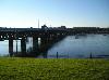
| Walney Island FeatureType : isle Elevation : 18 Lat/Lng : 54.103 / -3.252 | The Isle of Walney, also known as Walney Island, is an island off the west coast of England, at the western end of Morecambe Bay in the Irish Sea. It is part of Barrow-in-Furness, separated from the mainland by Walney Channel, which is spanned by the Jubilee Bridge (...) |
| 3 | 
| Utqiagvik, Alaska FeatureType : city Lat/Lng : 71.3003 / -156.7358 | Utqiagvik, (Inupiaq: Utqiaġvik, IPA:), officially the City of Utqiaġvik, and previously Barrow is the largest city and the borough seat of the North Slope Borough in the U.S. state of Alaska and is located north of the Arctic Circle (...) |
| 4 | 
| The Gambia FeatureType : country Lat/Lng : 13.4667 / -16.6 | The Gambia , officially the Republic of The Gambia, is a country in West Africa that is almost entirely surrounded by Senegal with the exception of its western coastline along the Atlantic Ocean. It is the smallest country within mainland Africa.Hoare, Ben (...) |
| 5 | 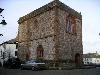
| Dalton-in-Furness FeatureType : city Elevation : 42 Lat/Lng : 54.1544 / -3.1814 | Dalton-in-Furness is a small town of 8,125 people, north east of Barrow-in-Furness, in Cumbria, England. It is the second largest settlement in the Borough of Barrow-in-Furness after Barrow itself and is most noted for being the location of South Lakes Safari Zoo. (...) |
| 6 | Barrow County, Georgia FeatureType : adm2nd Elevation : 299 Lat/Lng : 33.99 / -83.71 | Barrow County is a county located in the north central portion of the U.S. state of Georgia. As of the 2010 census, the population was 69,367. The county seat is Winder. Barrow County is included in the Atlanta-Sandy Springs-Roswell, GA Metropolitan Statistical Area. (...) | |
| 7 | 
| Barrow Island (Western Australia) FeatureType : isle Elevation : 52 Lat/Lng : -20.811 / 115.391 | Barrow Island is a island northwest off the Pilbara coast of Western Australia. The island is the second largest in Western Australia after Dirk Hartog Island. (...) |
| 8 | 
| Chukchi Sea FeatureType : waterbody Lat/Lng : 69.6886 / -171.4553 | Chukchi Sea is a marginal sea of the Arctic Ocean. It is bounded on the west by the Long Strait, off Wrangel Island, and in the east by Point Barrow, Alaska, beyond which lies the Beaufort Sea. The Bering Strait forms its southernmost limit and connects it to the Bering Sea and the Pacific Ocean (...) |
| 9 | 
| Hallstatt FeatureType : null Elevation : 510 Lat/Lng : 47.562 / 13.649 | Hallstatt (; Central Bavarian: Hoistod) is a small town in the district of Gmunden, in the Austrian state of Upper Austria. Situated between the southwestern shore of Hallstätter See and the steep slopes of the Dachstein massif, the town lies in Salzkammergut region, on the national road linking (...) |
| 10 | 
| Victoria Island (Canada) FeatureType : isle Lat/Lng : 71.0 / -110.0 | Victoria Island (or Kitlineq) is a large island in the Canadian Arctic Archipelago that straddles the boundary between Nunavut and the Northwest Territories of Canada. It is the eighth largest island in the world, and at in area, it is Canada's second largest island (...) |
| 11 | 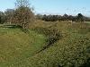
| Avebury FeatureType : landmark Elevation : 160 Lat/Lng : 51.4293 / -1.8528 | Avebury is a Neolithic henge monument containing three stone circles, around the village of Avebury in Wiltshire, in southwest England. One of the best known prehistoric sites in Britain, it contains the largest megalithic stone circle in the world (...) |
| 12 | River Barrow FeatureType : river Elevation : 0 Lat/Lng : 52.278 / -7.0006 | The Barrow is a river in Ireland. It is one of The Three Sisters; the other two being the River Suir and the River Nore. The Barrow is the longest of the three rivers. At 192 km (120 mi), it is the second-longest river in Ireland, behind the River Shannon (...) | |
| 13 | 
| Västerås FeatureType : null Elevation : 30 Lat/Lng : 59.6167 / 16.5333 | Västerås is a city in central Sweden, located on the shore of Lake Mälaren in the province Västmanland, some west of Stockholm. The city had a population of 119,372 inhabitants in 2016, out of the municipal total of 150,000 (2017).http://www.statistikdatabasen.scb (...) |
| 14 | 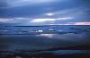
| Beaufort Sea FeatureType : waterbody Lat/Lng : 72.0278 / -137.0417 | The Beaufort Sea is a marginal sea of the Arctic Ocean, located north of the Northwest Territories, the Yukon, and Alaska, and west of Canada's Arctic islands. The sea is named after Sir Francis Beaufort, a hydrographer (...) |
| 15 | 
| Irish Sea FeatureType : waterbody Lat/Lng : 53.7217 / -5.1772 | The Irish Sea (Cambridge Medieval Celtic Studies, Issues 33–35 University of Cambridge (Gran Bretaña). Department of Anglo-Saxon, Norse and Celtic 1997 Ulster-Scots: Airish Sea) separates the islands of Ireland and Great Britain; linked to the Celtic Sea in the south by St George's Channel, and to (...) |
| 16 | Barrow and Furness (UK Parliament constituency) FeatureType : null Elevation : 31 Lat/Lng : 54.112 / -3.178 | Barrow and Furness (previously Barrow-in-Furness) is a constituency in Cumbria represented in the House of Commons of the UK Parliament since 2010 by John Woodcock. On 30 April 2018, he was suspended from the Labour Party following a sexual harassment allegation made against him (...) | |
| 17 | 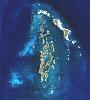
| Montebello Islands FeatureType : isle Elevation : 6 Lat/Lng : -20.4667 / 115.5333 | The Montebello Islands, also known as the Monte Bello Islands, are an archipelago of around 174 small islands (about 92 of which are named) lying north of Barrow Island and off the Pilbara coast of north-western Australia. Montebello is Italian for "beautiful mountain" (...) |
| 18 | 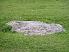
| Stonehenge FeatureType : landmark Elevation : 102 Lat/Lng : 51.1789 / -1.8266 | Stonehenge is a prehistoric monument in Wiltshire, England, west of Amesbury. It consists of a ring of standing stones, with each standing stone around high, wide and weighing around 25 tons. The stones are set within earthworks in the middle of the most dense complex of Neolithic and Bronze Age (...) |
| 19 | 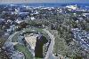
| Nassau, Bahamas FeatureType : null Elevation : 7 Lat/Lng : 25.06 / -77.345 | Nassau is the capital and commercial centre of the Commonwealth of the Bahamas. The city has an estimated population of 274,400 as of 2016, just over 70% of the population of the country (≈391,000). Lynden Pindling International Airport, the major airport for the Bahamas, is located about west of (...) |
| 20 | 
| Kerch FeatureType : null Elevation : 1 Lat/Lng : 45.36 / 36.48 | Kerch (Old East Slavic: Кърчевъ, Ancient Greek: Pantikapaion) is a city of regional significance on the Kerch Peninsula in the east of the Crimea. Population: Founded 2,600 years ago as an ancient Greek colony, Kerch is considered to be one of the most ancient cities in Crimea (...) |
| 21 | 
| Waterford FeatureType : null Elevation : 28 Lat/Lng : 52.252 / -7.127 | Waterford (from Old Norse Veðrafjǫrðr, meaning "ram (wether) fjord") is a city in Ireland. It is in County Waterford in the south east of Ireland and is part of the province of Munster. The city is situated at the head of Waterford Harbour. It is the oldest . Waterfordcity.ie (...) |
| 22 | 
| Kendal FeatureType : null Elevation : 46 Lat/Lng : 54.3261 / -2.745 | Kendal, known earlier as Kirkby in Kendal or Kirkby Kendal, is a market town and civil parish within the South Lakeland District of Cumbria, England. Historically in Westmorland, it is situated about south-east of Windermere, north of Lancaster, north-east of Barrow-in-Furness and north-west of (...) |
| 23 | 
| Phoenix, Arizona FeatureType : null Elevation : 366 Lat/Lng : 33.4483 / -112.0739 | Phoenix is the capital and most populous city of the U.S. state of Arizona. With 1,626,078 people , Phoenix is the fifth most populous city nationwide, the most populous state capital in the United States, and the only state capital with a population of more than one million residents (...) |
| 24 | 
| Carlisle FeatureType : null Elevation : 20 Lat/Lng : 54.891 / -2.9439 | Carlisle (or from Cumbric: Caer LuelSnyder, Christopher A. The Britons. John Wiley and Sons, 2003. p.204The Spirit of Hadrian's Wall. Cicerone Press Limited, 2008. p.177) is a city and the county town of Cumbria (...) |
| 25 | 
| Teide FeatureType : mountain Elevation : 3689 Lat/Lng : 28.2723 / -16.6425 | Mount Teide ("Teide Peak") is a volcano on Tenerife in the Canary Islands, Spain. Its 3,718-metre (12,198 ft) summit is the highest point in Spain and the highest point above sea level in the islands of the Atlantic (...) |
| 26 | 
| Snowdon FeatureType : mountain Elevation : 1010 Lat/Lng : 53.0689 / -4.0756 | Snowdon is the highest mountain in Wales, at an elevation of above sea level, and the highest point in the British Isles outside the Scottish Highlands. It is located in Snowdonia National Park in Gwynedd. It is the busiest mountain in the United Kingdom and the third most visited attraction in (...) |
| 27 | 
| Douglas, Isle of Man FeatureType : null Elevation : 62 Lat/Lng : 54.1452 / -4.4817 | Douglas is the capital and largest town of the Isle of Man, with a population of 27,938 (2011). It is located at the mouth of the River Douglas, and on a sweeping bay of two miles. The River Douglas forms part of the town's harbour and main commercial port (...) |
| 28 | 
| North Uist FeatureType : isle Elevation : 204 Lat/Lng : 57.6058 / -7.3414 | North Uist is an island and community in the Outer Hebrides of Scotland. (...) |
| 29 | 
| Belize FeatureType : country Elevation : 69 Lat/Lng : 17.25 / -88.75 | Belize , is a country located on the eastern coast of Central America. Belize is bordered on the northwest by Mexico, on the east by the Caribbean Sea, and on the south and west by Guatemala. It has an area of and a population of 387,879 (2017). Its mainland is about long and wide (...) |
| 30 | 
| Møn FeatureType : isle Elevation : 2 Lat/Lng : 54.9871 / 12.3528 | Møn is an island in south-eastern Denmark. Until 1 January 2007, it was a municipality in its own right but it is now part of the municipality of Vordingborg, after merging with the former municipalities of Langebæk, Præstø, and Vordingborg (...) |
| 31 | 
| Tralee FeatureType : null Elevation : 7 Lat/Lng : 52.2675 / -9.6962 | Tralee is the county town of County Kerry in the south-west of Ireland. The town is on the northern side of the neck of the Dingle Peninsula, and is the largest town in County Kerry. The town's population including suburbs was 23,691 census making it the 8th largest town, and 14th largest urban (...) |
| 32 | 
| Dearborn, Michigan FeatureType : city Elevation : 175 Lat/Lng : 42.3113 / -83.2135 | Dearborn is a city in the State of Michigan. It is located in Wayne County and is part of the Detroit metropolitan area. Dearborn is the eighth largest city in the State of Michigan. As of the 2010 census, it had a population of 98,153 and is home to the largest Muslim population in the United (...) |
| 33 | 
| South Uist FeatureType : isle Elevation : 229 Lat/Lng : 57.267 / -7.317 | South Uist is the second-largest island of the Outer Hebrides in Scotland. At the 2011 census, it had a usually resident population of 1,754: a decrease of 64 since 2001. The island, in common with the rest of the Hebrides, is one of the last remaining strongholds of the Gaelic language in Scotland (...) |
| 34 | 
| Lancaster, Lancashire FeatureType : null Elevation : 24 Lat/Lng : 54.047 / -2.801 | Lancaster is the county town of Lancashire, England. It is on the River Lune and has a population of 52,234; the wider City of Lancaster local government district has a population of 138,375. Long a commercial, cultural and educational centre, Lancaster gives Lancashire its name (...) |
| 35 | 
| Utrecht FeatureType : null Elevation : 9 Lat/Lng : 52.0889 / 5.1156 | Utrecht is the fourth-largest city and a municipality of the Netherlands, capital and most populous city of the province of Utrecht. It is located in the eastern corner of the Randstad conurbation and had a population of in (...) |
| 36 | 
| Basingstoke FeatureType : null Elevation : 85 Lat/Lng : 51.2667 / -1.0876 | Basingstoke is the largest town in the modern county of Hampshire (Southampton and Portsmouth being cities). It is situated in south central England, and lies across a valley at the source of the River Loddon. It is located northeast of Southampton, southwest of London, and northeast of the county (...) |
| 37 | 
| Little Rock, Arkansas FeatureType : city Elevation : 93 Lat/Lng : 34.7361 / -92.3311 | Little Rock is the capital and most populous city of the U.S. state of Arkansas. It is also the county seat of Pulaski County. It was incorporated on November 7, 1831, on the south bank of the Arkansas River close to the state's geographic center (...) |
| 38 | Barrow FeatureType : null Lat/Lng : -63.7157 / -61.7041 | Barrow may refer to: (...) | |
| 39 | 
| Bath, Somerset FeatureType : null Elevation : 19 Lat/Lng : 51.3794 / -2.367 | Bath is the largest city in the ceremonial county of Somerset, England, known for its Roman-built baths. In 2011, the population was 88,859.(Combined populations of the 16 wards that make-up the unparished area.) Bath is in the valley of the River Avon, west of London and south-east of Bristol (...) |
| 40 | 
| Colchester FeatureType : city Elevation : 24 Lat/Lng : 51.8917 / 0.903 | Colchester is an historic market town and the largest settlement within the borough of Colchester in the county of Essex. At the time of the 2011 UK Census, it had a population of 121,859, marking a considerable rise from the previous census and with considerable development since 2001 and ongoing (...) |
| 41 | 
| Zanzibar FeatureType : adm1st Elevation : 28 Lat/Lng : -6.1333 / 39.3167 | Zanzibar is a semi-autonomous region of Tanzania. It is composed of the Zanzibar Archipelago in the Indian Ocean, off the coast of the mainland, and consists of many small islands and two large ones: Unguja (the main island, referred to informally as Zanzibar) and Pemba Island (...) |
| 42 | 
| Baltic Sea FeatureType : waterbody Lat/Lng : 58.0 / 20.0 | The Baltic Sea is a marginal sea of the Atlantic Ocean, enclosed by Finland, Sweden, Denmark, Estonia, Latvia, Lithuania, northwest Russia, Poland, Germany and the North and Central European Plain. The sea stretches from 53°N to 66°N latitude and from 10°E to 30°E longitude (...) |
| 43 | 
| Lima, Ohio FeatureType : null Elevation : 271 Lat/Lng : 40.7408 / -84.115 | Lima is a city in and the county seat of Allen County, Ohio, United States. The municipality is located in northwestern Ohio along Interstate 75 approximately north of Dayton and south-southwest of Toledo. As of the 2010 census, the city had a population of 38,771 (...) |
| 44 | 
| Delray Beach, Florida FeatureType : null Elevation : 10 Lat/Lng : 26.4592 / -80.0831 | Delray Beach is a coastal city in Palm Beach County, Florida, United States. The population of Delray Beach was estimated at 67,371 in 2016. That is up from 60,522 according to the 2010 United States Census. Delray Beach is a principal city of the Miami metropolitan area, which was home to an (...) |
| 45 | 
| Barbados FeatureType : country Elevation : 193 Lat/Lng : 13.1667 / -59.5667 | Barbados (or) is an island country in the Lesser Antilles of the West Indies, in the Caribbean region of North America. It is in length and up to in width, covering an area of . It is situated in the western area of the North Atlantic and east of the Windward Islands and the Caribbean Sea; – U.S (...) |
| 46 | 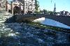
| Mälaren FeatureType : waterbody Elevation : 3 Lat/Lng : 59.4336 / 17.0673 | Mälaren , historically referred to as Lake Malar in English, is the third-largest freshwater lake in Sweden (after Vänern and Vättern). Its area is 1,140 km² and its greatest depth is 64 m. Mälaren spans 120 kilometers from east to west (...) |
| 47 | 
| Whitehaven FeatureType : null Elevation : 11 Lat/Lng : 54.548 / -3.5855 | Whitehaven is a town and port on the coast of Cumbria, England. Historically a part of Cumberland, it lies equidistant between Cumbria's two largest settlements, Carlisle and Barrow-in-Furness. It is the administrative seat of Borough of Copeland district council, and has a town council for the (...) |
| 48 | 
| Richmond Park FeatureType : landmark Elevation : 26 Lat/Lng : 51.4494 / -0.2739 | Richmond Park, in the London Borough of Richmond upon Thames, was created by Charles I in the 17th century as a deer park. The largest of London's Royal Parks, it is of national and international importance for wildlife conservation (...) |
| 49 | 
| Edinburgh Castle FeatureType : landmark Elevation : 105 Lat/Lng : 55.9486 / -3.2008 | Edinburgh Castle is a historic fortress which dominates the skyline of the city of Edinburgh, Scotland, from its position on the Castle Rock. Archaeologists have established human occupation of the rock since at least the Iron Age (2nd century AD), although the nature of the early settlement is (...) |
| 50 | 
| Nairobi FeatureType : landmark Elevation : 1684 Lat/Lng : -1.2833 / 36.8167 | Nairobi is the capital and the largest city of Kenya. The name comes from the Maasai phrase Enkare Nairobi, which translates to "cool water", a reference to the Nairobi River which flows through the city. The city proper had a population of 3,138,369 in the 2009 census, while the metropolitan area (...) |
| 51 | 
| Aarhus FeatureType : city Elevation : 28 Lat/Lng : 56.1629 / 10.2039 | Aarhus (; officially spelled Århus from 1948 until 31 December 2010) is the second-largest city in Denmark and the seat of Aarhus municipality. It is located on the east coast of the Jutland peninsula, in the geographical centre of Denmark, northwest of Copenhagen and north of Hamburg, Germany (...) |
| 52 | 
| Cardiff FeatureType : city Elevation : 10 Lat/Lng : 51.4827 / -3.1823 | Cardiff is the capital of Wales, and its largest city. The eleventh-largest city in the United Kingdom, it is Wales's chief commercial centre, the base for most national cultural institutions and Welsh media, and the seat of the National Assembly for Wales (...) |
| 53 | 
| Detroit FeatureType : null Elevation : 192 Lat/Lng : 42.3314 / -83.0458 | Detroit is the largest and most populous city in the U.S. state of Michigan, the largest city on the United States–Canada border, and the seat of Wayne County. The municipality of Detroit had a 2017 estimated population of 673,104, making it the 23rd-most populous city in the United States (...) |
| 54 | 
| British Museum FeatureType : landmark Elevation : 39 Lat/Lng : 51.5195 / -0.1269 | The British Museum, located in the Bloomsbury area of London, in the United Kingdom, is a public institution dedicated to human history, art and culture. Its permanent collection numbers some 8 million works, and is among the largest and most comprehensive in existence having been widely sourced (...) |
| 55 | 
| Charleston, South Carolina FeatureType : null Elevation : 10 Lat/Lng : 32.7761 / -79.9325 | Charleston is the oldest and largest city in the U.S. state of South Carolina, the county seat of Charleston County, and the principal city in the Charleston–North Charleston–Summerville Metropolitan Statistical Area.As defined by the U.S. Office of Management and Budget, for use by the U.S (...) |
| 56 | 
| New Providence FeatureType : isle Elevation : 6 Lat/Lng : 25.0265 / -77.3709 | New Providence is the most populous island in The Bahamas, containing more than 70% of the total population. It is the location of the national capital city of Nassau, whose boundaries are coincident with the island; it had a population of 246,329 at the 2010 Census; the latest estimate (2016) is (...) |
| 57 | 
| Mthatha FeatureType : null Elevation : 695 Lat/Lng : -31.5885 / 28.79 | Mthatha , is the main town of the King Sabata Dalindyebo Local Municipality in Eastern Cape province of South Africa and the capital of OR Tambo District Municipality. The town has an airport, previously known by the name K. D. Matanzima Airport after former leader Kaiser Matanzima (...) |
| 58 | Barrow Island, Barrow-in-Furness FeatureType : landmark Elevation : 22 Lat/Lng : 54.103 / -3.232 | Barrow Island is an area and electoral ward of Barrow-in-Furness, Cumbria, England. Originally separate from the British mainland, land reclamation in the 1860s saw the northern fringes of the island connect to Central Barrow (...) | |
| 59 | Cumbria FeatureType : adm2nd Elevation : 145 Lat/Lng : 54.57 / -2.91 | Cumbria is a ceremonial and non-metropolitan county in North West England. The county and Cumbria County Council, its local government, came into existence in 1974 after the passage of the Local Government Act 1972 (...) | |
| 60 | 
| Bourke, New South Wales FeatureType : city Elevation : 108 Lat/Lng : -30.0914 / 145.9411 | Bourke is a town in the north-west of New South Wales, Australia. The administrative centre and largest town in Bourke Shire, Bourke is approximately north-west of the state capital, Sydney, on the south bank of the Darling River. (...) |
| 61 | 
| Nebra sky disk FeatureType : landmark Elevation : 255 Lat/Lng : 51.2839 / 11.52 | The Nebra sky disk is a bronze disk of around diameter and a weight of , with a blue-green patina and inlaid with gold symbols. These are interpreted generally as a sun or full moon, a lunar crescent, and stars (including a cluster interpreted as the Pleiades) (...) |
| 62 | 
| Americus, Georgia FeatureType : city Elevation : 133 Lat/Lng : 32.0753 / -84.2267 | Americus is a city in Sumter County, Georgia, United States. As of the 2010 census, the city had a population of 17,041. Americus is the home of Habitat for Humanity's international headquarters, the famous Windsor Hotel (from 1892), The Fuller Center for Housing international headquarters, The (...) |
| 63 | 
| Gower Peninsula FeatureType : landmark Elevation : 36 Lat/Lng : 51.5915 / -4.2163 | Gower or the Gower Peninsula is in South Wales. It projects westwards into the Bristol Channel and is the most westerly part of the historic county of Glamorgan. In 1956, Gower became the first area in the United Kingdom to be designated an Area of Outstanding Natural Beauty (...) |
| 64 | 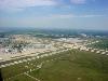
| Kansas City International Airport FeatureType : airport Elevation : 304 Lat/Lng : 39.2975 / -94.7139 | Kansas City International Airport (originally Mid-Continent International Airport) is a public airport 15 miles (24 km) northwest of downtown Kansas City in Platte County, Missouri., effective October 25, 2007. In 2017, 11.50 million passengers used the airport (...) |
| 65 | 
| Geography of Ireland FeatureType : isle Elevation : 126 Lat/Lng : 53.0 / -8.0 | is an island in Northwestern Europe in the north Atlantic Ocean. The island lies on the European continental shelf, part of the Eurasian Plate. The island's main geographical features include low central plains surrounded by coastal mountains (...) |
| 66 | 
| Devizes FeatureType : city Elevation : 133 Lat/Lng : 51.353 / -1.994 | Devizes is a market town and civil parish in the centre of Wiltshire, England. It developed around Devizes Castle, an 11th-century Norman castle, and received a charter in 1141 permitting regular markets, which are held weekly in an open market place (...) |
| 67 | 
| Trans-Alaska Pipeline System FeatureType : landmark Lat/Lng : 70.2572 / -148.6189 | The Trans-Alaska Pipeline System (TAPS) includes the trans-Alaska crude-oil pipeline, 11 pump stations, several hundred miles of feeder pipelines, and the Valdez Marine Terminal. TAPS is one of the world's largest pipeline systems (...) |
| 68 | 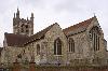
| Farnham FeatureType : null Elevation : 71 Lat/Lng : 51.215 / -0.799 | Farnham is a town in Surrey, England, within the Borough of Waverley.OS Explorer map 145:Guildford and Farnham. Scale: 1:25 000. Publisher:Ordnance Survey – Southampton. The town is southwest of London in the extreme west of Surrey, adjacent to the border with Hampshire (...) |
| 69 | 
| Bracknell FeatureType : null Elevation : 82 Lat/Lng : 51.416 / -0.749 | Bracknell is a town and civil parish in Berkshire, England, the westernmost area within the Greater London Urban Area and the administrative centre of the Borough of Bracknell Forest. It lies to the east of Reading, south of Maidenhead, southwest of Windsor and west of central London (...) |
| 70 | 
| Barra FeatureType : isle Elevation : 211 Lat/Lng : 56.9833 / -7.4667 | Barra (h) is an island in the Outer Hebrides, Scotland, and the second southernmost inhabited island there, after the adjacent island of Vatersay to which it is connected by a short causeway. In 2011, the population was 1,174. (...) |
| 71 | 
| Barry, Vale of Glamorgan FeatureType : null Elevation : 37 Lat/Lng : 51.4064 / -3.2667 | Barry is a town and community (the largest in Wales) in the Vale of Glamorgan, Wales, on the north coast of the Bristol Channel approximately south-southwest of Cardiff. Barry is a seaside resort, with attractions including several beaches the resurrected Barry Island Pleasure Park (...) |
| 72 | 
| Benbecula FeatureType : isle Elevation : 10 Lat/Lng : 57.4458 / -7.3196 | Benbecula (; or) is an island of the Outer Hebrides, in the Atlantic Ocean off the west coast of Scotland. In the 2011 census it had a usually resident population of 1,283, with a sizable percentage of Roman Catholics. It forms part of the area administered by or the Western Isles Council. (...) |
| 73 | 
| Sellafield FeatureType : landmark Elevation : 26 Lat/Lng : 54.4205 / -3.4975 | Sellafield is a nuclear fuel reprocessing and nuclear decommissioning site, close to the village of Seascale on the coast of the Irish Sea in Cumbria, England. The site is served by Sellafield railway station. Sellafield incorporates the original nuclear reactor site at Windscale, which is currently (...) |
| 74 | 
| Todmorden FeatureType : null Elevation : 133 Lat/Lng : 53.7136 / -2.0978 | Todmorden See page 828 of John C. Wells's LPD. Also, see and Peter Wright, A Yorkshireman's Dictionary, page 8 is a market town and civil parish in the Upper Calder Valley in Calderdale, West Yorkshire, England. It is north east of Manchester and in 2011 had a population of 15,481 (...) |
| 75 | Point Barrow FeatureType : landmark Lat/Lng : 71.3889 / -156.4792 | Point Barrow or Nuvuk is a headland on the Arctic coast in the U.S. state of Alaska, northeast of Utqiagvik. It is the northernmost point of all the territory of the United States, at . The distance to the North Pole is (...) | |
| 76 | 
| Eigg FeatureType : isle Elevation : 73 Lat/Lng : 56.9038 / -6.155 | Eigg is one of the Small Isles, in the Scottish Inner Hebrides. It lies to the south of the Skye and to the north of the Ardnamurchan peninsula. Eigg is long from north to south, and east to west. With an area of , it is the second largest of the Small Isles after Rùm (...) |
| 77 | Port of Barrow FeatureType : landmark Elevation : 3 Lat/Lng : 54.108 / -3.227 | The Port of Barrow refers to the enclosed dock system within the town of Barrow-in-Furness, England. Morecambe Bay is to the east of the port and the Irish Sea surrounds it to the south and west. The port is currently owned and operated by Associated British Ports Holdings, but some land is shared (...) | |
| 78 | 
| Heysham FeatureType : null Elevation : 16 Lat/Lng : 54.0289 / -2.9161 | Heysham is a large coastal village in Lancashire, England, overlooking Morecambe Bay. It is a ferry port, with services to the Isle of Man and Ireland, and the site of two nuclear power stations. (...) |
| 79 | 
| Rùm FeatureType : isle Elevation : 226 Lat/Lng : 56.9996 / -6.3344 | Rùm , a Scottish Gaelic name often anglicised to Rum, is one of the Small Isles of the Inner Hebrides, in the district of Lochaber, Scotland. For much of the 20th century the name became Rhum, a spelling invented by the former owner, Sir George Bullough, because he did not relish the idea of having (...) |
| 80 | 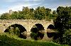
| Ludlow FeatureType : null Elevation : 108 Lat/Lng : 52.3681 / -2.7176 | Ludlow is a market town in Shropshire, England, south of Shrewsbury and north of Hereford via the main A49 road, which bypasses the town. With a population of approximately 11,000, Ludlow is the largest town in South Shropshire (...) |
| 81 | 
| Mývatn FeatureType : waterbody Lat/Lng : 65.6103 / -17.01 | Mývatn is a shallow eutrophic lake situated in an area of active volcanism in the north of Iceland, not far from Krafla volcano. The lake and its surrounding wetlands have an exceptionally rich fauna of waterbirds, especially ducks (...) |
| 82 | Borough of Barrow-in-Furness FeatureType : adm2nd Elevation : 58 Lat/Lng : 54.1289 / -3.2233 | Barrow-in-Furness is a local government district with borough status in Cumbria, England. It is named after its main town, Barrow-in-Furness. Other settlements include Dalton-in-Furness and Askam-in-Furness. It is the smallest district in the county, but is the most densely populated, with 924 (...) | |
| 83 | 
| Will Rogers World Airport FeatureType : null Elevation : 395 Lat/Lng : 35.3931 / -97.6008 | Will Rogers World Airport , Will Rogers Airport or simply Will Rogers, is an American passenger airport in Oklahoma City located about 6 miles (8 km) Southwest of downtown Oklahoma City. It is a civil-military airport on 8,081 acres (3,270 ha) of land., effective March 1, 2018 (...) |
| 84 | 
| Scone, Scotland FeatureType : null Elevation : 50 Lat/Lng : 56.4194 / -3.4019 | Scone is a village in Perth and Kinross, Scotland. The medieval village of Scone, which grew up around the monastery and royal residence, was abandoned in the early 19th century when the residents were removed and a new palace was built on the site by the Earl of Mansfield (...) |
| 85 | Furness FeatureType : landmark Elevation : 37 Lat/Lng : 54.27 / -3.0885 | Furness is a peninsula and region of Cumbria in northwestern England. Together with the Cartmel Peninsula it forms North Lonsdale, historically an exclave of Lancashire. The Furness Peninsula, also known as Low Furness, is an area of villages, agricultural land and low-lying moorland, with the (...) | |
| 86 | Barrow Island Airport FeatureType : null Elevation : 6 Lat/Lng : -20.8644 / 115.406 | Barrow Island Airport is located at Barrow Island, Western Australia. (...) | |
| 87 | County Kilkenny FeatureType : adm1st Elevation : 62 Lat/Lng : 52.57 / -7.24 | County Kilkenny is a county in Ireland. It is in the province of Leinster and is part of the South-East Region. It is named after the city of Kilkenny. Kilkenny County Council is the local authority for the county. As of the 2016 census the population of the county was 99,232 (...) | |
| 88 | 
| Japanese battleship Kongō FeatureType : landmark Lat/Lng : 26.15 / 121.3833 | Kongō (金剛, "Indestructible Diamond", named for Mount Kongō) was a warship of the Imperial Japanese Navy during World War I and World War II. She was the first battlecruiser of the , among the most heavily armed ships in any navy when built (...) |
| 89 | County Carlow FeatureType : adm1st Elevation : 84 Lat/Lng : 52.73 / -6.82 | County Carlow is a county in Ireland, part of the South-East Region and the province of Leinster. It is named after the town of Carlow, which lies on the River Barrow. Carlow County Council is the local authority. The population was 56,875 at the 2016 census. (...) | |
| 90 | 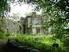
| Lake District FeatureType : null Elevation : 968 Lat/Lng : 54.4542 / -3.2115 | The Lake District, also known as the Lakes or Lakeland, is a mountainous region in North West England. A popular holiday destination, it is famous for its lakes, forests and mountains (or fells), and its associations with William Wordsworth and other Lake Poets and also with Beatrix Potter and John (...) |
| 91 | 
| Brobergen FeatureType : city Elevation : 4 Lat/Lng : 53.5967 / 9.1878 | Brobergen (Low Saxon: Brobargen) is a village in the German municipality of Kranenburg in the district of Stade, Lower Saxony. The village of 6.06 km² has 220 inhabitants (July 1, 2011). The village lies on the right (eastern) bank of the Oste river (...) |
| 92 | 
| Uffington White Horse FeatureType : landmark Elevation : 234 Lat/Lng : 51.5777 / -1.5666 | The Uffington White Horse is a highly stylised prehistoric hill figure, long, formed from deep trenches filled with crushed white chalk. The figure is situated on the upper slopes of White Horse Hill in the English civil parish of Uffington (in the ceremonial county of Oxfordshire and historic (...) |
| 93 | 
| Lake Merritt FeatureType : waterbody Elevation : -2 Lat/Lng : 37.8039 / -122.2591 | Lake Merritt is a large tidal lagoon in the center of Oakland, California, just east of Downtown. It is surrounded by parkland and city neighborhoods. It is historically significant as the United States' first official wildlife refuge, designated in 1870, and has been listed as a National Historic (...) |
| 94 | 
| Gamla Uppsala FeatureType : city Elevation : 32 Lat/Lng : 59.8937 / 17.6378 | Gamla Uppsala (Old Uppsala) is a parish and a village outside Uppsala in Sweden. It had 17,973 inhabitants in 2016.http://www.geonames.org/2661886/sweden.html As early as the 3rd century AD and the 4th century AD and onwards, it was an important religious, economic and political centre (...) |
| 95 | Carlow FeatureType : null Elevation : 52 Lat/Lng : 52.836 / -6.9245 | Carlow is the county town of County Carlow, in the south-east of Ireland, from Dublin. At the 2016 census, it had a combined urban and rural population of 24,272. The county of Carlow has a population of 56,932 (...) | |
| 96 | Bonnie and Clyde FeatureType : landmark Elevation : 80 Lat/Lng : 32.4403 / -93.0933 | Bonnie Elizabeth Parker (October 1, 1910 – May 23, 1934) and Clyde Champion Barrow (March 24, 1909 – May 23, 1934) were American criminals who traveled the central United States with their gang, during the Great Depression, robbing people and killing when cornered or confronted (...) | |
| 97 | Barrow, Cheshire FeatureType : null Elevation : 34 Lat/Lng : 53.22 / -2.788 | Barrow is a civil parish containing the villages of Great Barrow, Little Barrow and Stamford Bridge. It is situated about east-north-east of Chester, north-west of Tarporley, and south of Frodsham. Little Barrow formerly had a station on the Mid-Cheshire line, named Barrow for Tarvin, but it closed (...) | |
| 98 | Winder, Georgia FeatureType : city Elevation : 301 Lat/Lng : 33.9964 / -83.7208 | Winder (pronounced WINE-der) is a city in Barrow County, Georgia, United States. It is located east of Atlanta and is part of the Atlanta metropolitan area. The population was 14,099 at the 2010 census. The city is the county seat of Barrow County. (...) | |
| 99 | River Nore FeatureType : river Elevation : -1 Lat/Lng : 52.4167 / -6.95 | The River Nore is a long river located in south-east of Ireland. Along with the River Suir and River Barrow, it is one of the constituent rivers of the group known as the Three Sisters. The river drains approximately of Leinster. The long term average flow rate of the River Nore is 42 (...) | |
| 100 | Chestnuts Long Barrow FeatureType : null Elevation : 55 Lat/Lng : 51.3077 / 0.3696 | The Chestnuts Long Barrow, also known as Stony or Long Warren, is a chambered long barrow located near to the village of Addington in the southeastern English county of Kent. Constructed circa 4000 BCE, during the Early Neolithic period of British prehistory, today it survives only in a ruined state (...) | |
| 101 | Barrow Island FeatureType : null Elevation : 342 Lat/Lng : 46.4834 / -82.1012 | Barrow Island may refer to: * Barrow Island (Western Australia), Australia * Barrow Island (Queensland), Australia * Barrow Island, Barrow-in-Furness, England | |
| 102 | Grade I listed buildings in Cumbria FeatureType : null Elevation : 42 Lat/Lng : 54.8653 / -3.1193 | There are over 9000 Grade I listed buildings in England. This page is a list of these buildings in the county of Cumbria, sub-divided by district. (...) | |
| 103 | Eberdingen FeatureType : null Elevation : 262 Lat/Lng : 48.8809 / 8.9642 | Eberdingen is a municipality in the district of Ludwigsburg (Baden-Württemberg, Germany). It is part of the Neckar Region and the metropolitan area of Stuttgart. The municipality consists of the three communities of Eberdingen, Hochdorf an der Enz, and Nussdorf (...) | |
| 104 | Viscount Melville Sound FeatureType : waterbody Lat/Lng : 74.0 / -108.0 | Viscount Melville Sound is an arm of the Arctic Ocean in Kitikmeot, Nunavut, Canada. Forming part of the Parry Channel, it separates Victoria Island and Prince of Wales Island from the Queen Elizabeth Islands. East of the sound, via Barrow Strait, lies Lancaster Sound, leading into Baffin Bay; (...) | |
| 105 | Ulverston FeatureType : city Elevation : 23 Lat/Lng : 54.1954 / -3.0918 | Ulverston is a market town in the South Lakeland district of Cumbria in North West England. Historically in Lancashire, the town is in the Furness area north-east of Barrow-in-Furness. It is close to the Lake District, and just north of Morecambe Bay, neighboured by Swarthmoor, Pennington and (...) | |
| 106 | 
| Beechey Island FeatureType : isle Lat/Lng : 74.7104 / -91.8568 | Beechey Island (Inuktitut Iluvialuit) is an island located in the Canadian Arctic Archipelago of Nunavut, Canada, in Wellington Channel. It is separated from the southwest corner of Devon Island by Barrow Strait. Other features include Wellington Channel, Erebus Harbour, and Terror Bay. (...) |
| 107 | Gwinnett County, Georgia FeatureType : adm2nd Elevation : 292 Lat/Lng : 33.96 / -84.03 | Gwinnett County is a county in the north central portion of the U.S. state of Georgia. , the population is estimated to be 920,260, making it the second-most populous county in Georgia. Its county seat is Lawrenceville (...) | |
| 108 | 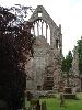
| Dryburgh Abbey FeatureType : landmark Elevation : 70 Lat/Lng : 55.5747 / -2.6497 | Dryburgh Abbey, near Dryburgh on the banks of the River Tweed in the Scottish Borders, was nominally founded on 10 November (Martinmas) 1150 in an agreement between Hugh de Morville, Constable of Scotland, and the Premonstratensian canons regular from Alnwick Abbey in Northumberland.Chron (...) |
| 109 | Barrow-in-Furness railway station FeatureType : railwaystation Elevation : 16 Lat/Lng : 54.119 / -3.226 | Barrow-in-Furness railway station is the largest railway station serving Barrow-in-Furness in Cumbria, England. It is the western terminus of the Furness Line to and the southern terminus of the Cumbrian Coast Line to , both of which connect to the West Coast Mainline. It is operated by Northern. (...) | |
| 110 | Barrow, Shropshire FeatureType : null Elevation : 211 Lat/Lng : 52.5972 / -2.5062 | Barrow is a hamlet and civil parish in Shropshire, England, some 5 miles south of Telford between Ironbridge and Much Wenlock. Although Barrow itself consists of a church and just a few dwellings, the parish extends from Broseley to the eastern edge of Much Wenlock; it also includes the hamlet of (...) | |
| 111 | Morecambe Bay FeatureType : waterbody Lat/Lng : 54.08 / -2.86 | Morecambe Bay is a large estuary in northwest England, just to the south of the Lake District National Park. It is the largest expanse of intertidal mudflats and sand in the United Kingdom, covering a total area of (...) | |
| 112 | 
| Jallianwala Bagh massacre FeatureType : landmark Elevation : 235 Lat/Lng : 31.6202 / 74.8805 | The Jallianwala Bagh massacre, also known as the Amritsar massacre, took place on 13 April 1919 when troops of the British Indian Army under the command of Colonel Reginald Dyer fired rifles into a crowd of Indians, who had gathered in Jallianwala Bagh, Amritsar, Punjab (...) |
| 113 | Barrow Gurney FeatureType : null Elevation : 101 Lat/Lng : 51.4061 / -2.681 | Barrow Gurney is a village and civil parish in Somerset, England, situated in the Unitary Authority of North Somerset on the B3130, midway between the A38 and A370 near the Long Ashton bypass and Bristol Airport, south west of Bristol city centre (...) | |
| 114 | The Waterfront Barrow-in-Furness FeatureType : landmark Elevation : 11 Lat/Lng : 54.1012 / -3.2192 | The Waterfront Barrow-in-Furness is a £200 million development under construction in and around the Port of Barrow, England. The site covers an area of some and was due for completion in 2020. The internal road network is already complete, with construction of a large business park complex ongoing (...) | |
| 115 | Barrow upon Soar FeatureType : city Elevation : 57 Lat/Lng : 52.7516 / -1.15 | Barrow upon Soar is a large village in northern Leicestershire, in the Soar Valley between Leicester and Loughborough. It has a population of around 5,000 and is part of the Charnwood local government district. The population as measured at the 2011 census was 5,856 (...) | |
| 116 | Albstadt FeatureType : null Elevation : 729 Lat/Lng : 48.2119 / 9.0239 | Albstadt is the largest city in the district of Zollernalbkreis in Baden-Württemberg, Germany. It is located on the Swabian Alb mountains, about halfway between Stuttgart and Lake of Constance. (...) | |
| 117 | 
| Castledermot FeatureType : city Elevation : 79 Lat/Lng : 52.9119 / -6.8378 | Castledermot (meaning "Dermot's Hermitage") is an inland village in the south-east of Ireland in County Kildare, about from Dublin, and from the town of Carlow. The N9 road from Dublin to Waterford previously passed through the village but upon completion of a motorway bypass in 2010, it was (...) |
| 118 | Borough of Charnwood FeatureType : adm2nd Elevation : 49 Lat/Lng : 52.769 / -1.204 | The Borough of Charnwood is a local government district with borough status in the north of Leicestershire, England, which has a population of 166,100 as of the 2011 census. It borders Melton to the east, Harborough to the south east, Leicester and Blaby to the south, Hinckley and Bosworth to the (...) | |
| 119 | Hall County, Georgia FeatureType : adm2nd Elevation : 387 Lat/Lng : 34.32 / -83.82 | Hall County is a county located in the north central portion of the U.S. state of Georgia. As of the 2010 census, the population was 179,684. The county seat is Gainesville. Hall County comprises the Gainesville, GA Metropolitan Statistical Area, which is also part of the Atlanta-Athens-Clarke (...) | |
| 120 | Jackson County, Georgia FeatureType : adm2nd Elevation : 253 Lat/Lng : 34.13 / -83.56 | Jackson County is a county located in the northeastern part of the U.S. state of Georgia. As of the 2010 census, the population was 60,485. The county seat is Jefferson. Jackson County comprises the Jefferson, GA Micropolitan Statistical Area, which is included in the Atlanta-Athens-Clarke (...) | |
| 121 | County Wexford FeatureType : adm1st Elevation : 94 Lat/Lng : 52.5 / -6.6667 | County Wexford is a county in Ireland. It is in the province of Leinster and is part of the South-East Region. It is named after the town of Wexford and was based on the historic Gaelic territory of Hy Kinsella (Uí Ceinnsealaigh), whose capital was Ferns.Furlong, p. 18 (...) | |
| 122 | Central Barrow FeatureType : adm3rd Elevation : 14 Lat/Lng : 54.11 / -3.22 | Central Barrow refers to the town centre of Barrow-in-Furness, Cumbria, England. Central Barrow is also the name of the electoral ward that covers roughly the eastern part of Barrow town centre. In 2001 5,584 (ranking 5th out of 13) lived in the Central ward. The population density was 55 (...) | |
| 123 | Abbey Road, Barrow-in-Furness FeatureType : landmark Elevation : 11 Lat/Lng : 54.1133 / -3.2329 | Abbey Road is the principal north to south arterial road through Barrow-in-Furness, Cumbria, England. (...) | |
| 124 | Robertson Bay FeatureType : null Lat/Lng : -71.4289 / 169.9036 | Robertson Bay is a large, roughly triangular bay that indents the north coast of Victoria Land between Cape Barrow and Cape Adare. Discovered in 1841 by Captain James Clark Ross, Royal Navy, who named it for Dr. John Robertson, Surgeon on HMS Terror. (...) | |
| 125 | Greene County, Illinois FeatureType : adm2nd Elevation : 166 Lat/Lng : 39.35 / -90.39 | Greene County is a county located in the U.S. state of Illinois. According to the 2010 United States Census, it has a population of 13,886. Its county seat is Carrollton. A notable archaeological area, the Koster Site, has produced evidence of more than 7,000 years of human habitation (...) | |
| 126 | 
| Woodhenge FeatureType : landmark Elevation : 98 Lat/Lng : 51.1893 / -1.7856 | Woodhenge is a Neolithic Class II henge and timber circle monument within the Stonehenge World Heritage Site in Wiltshire, England. It is north-east of Stonehenge, just north of the town of Amesbury. (...) |
| 127 | Ellis County, Texas FeatureType : adm2nd Elevation : 157 Lat/Lng : 32.35 / -96.79 | Ellis County is a county located in the U.S. state of Texas. As of the 2010 census, its population was 149,610. The county seat is Waxahachie. The county was founded in 1849 and organized the next year. It is named for Richard Ellis, president of the convention that produced the Texas Declaration of (...) | |
| 128 | 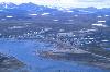
| Clyde River, Nunavut FeatureType : city Lat/Lng : 70.4733 / -68.5884 | Clyde River (Syllabics: ᑲᖏᖅᑐᒑᐱᒃ, official site in syllabics Inuktitut: Kanngiqtugaapik "nice little inlet" official site in English) is an Inuit hamlet located on the shore of Baffin Island's Patricia Bay, off Clyde Inlet, an arm of Davis Strait in the Qikiqtaaluk Region, of Nunavut Canada (...) |
| 129 | Barrow, Suffolk FeatureType : null Elevation : 92 Lat/Lng : 52.2441 / 0.5865 | Barrow is a village and civil parish in the St Edmundsbury district of Suffolk, England, about eight miles west of Bury St Edmunds. According to Eilert Ekwall the meaning of the village name is grove or wood, hill or mound. The Domesday Book records the population of Barrow in 1086 to have been 27. (...) | |
| 130 | Addington Long Barrow FeatureType : null Elevation : 59 Lat/Lng : 51.3079 / 0.3701 | Addington Long Barrow is a chambered long barrow located near to the village of Addington in the southeastern English county of Kent. Constructed during Britain's Early Neolithic period, today it survives only in a ruined state (...) | |
| 131 | West Kennet Long Barrow FeatureType : landmark Elevation : 175 Lat/Lng : 51.4086 / -1.8511 | The West Kennet Long Barrow is a Neolithic tomb or barrow, situated on a prominent chalk ridge, near Silbury Hill, one-and-a-half miles south of Avebury in Wiltshire, England. The site was recorded by John Aubrey in the 17th century and by William Stukeley in the 18th century (...) | |
| 132 | North West England FeatureType : adm2nd Elevation : 508 Lat/Lng : 54.0167 / -2.6333 | North West England, one of nine official regions of England, consists of the five counties of Cheshire, Cumbria, Greater Manchester, Lancashire and Merseyside. The North West had a population of 7,052,000 in 2011 (...) | |
| 133 | Barrow Strait FeatureType : waterbody Lat/Lng : 74.4015 / -94.1678 | Barrow Strait is a shipping waterway in Northern Canada's territory of Nunavut. Forming part of the Parry Channel, the strait separates several large islands including Cornwallis Island and Devon Island to the north, from Prince of Wales Island, Somerset Island, and Prince Leopold Island to the (...) | |
| 134 | Barrow Hill Engine Shed FeatureType : null Elevation : 63 Lat/Lng : 53.2744 / -1.3818 | Barrow Hill Roundhouse & Railway Centre, until 1948 known as Staveley Roundhouse & Train Centre, is a former Midland Railway roundhouse in Barrow Hill, near Staveley and Chesterfield, Derbyshire . (...) | |
| 135 | Battle of Bannockburn FeatureType : null Elevation : 35 Lat/Lng : 56.092 / -3.915 | The Battle of Bannockburn (or) 24 June 1314 was a significant Scottish victory in the First War of Scottish Independence, and a landmark in Scottish history. Stirling Castle, a Scots royal fortress occupied by the English, was under siege by the Scottish army (...) | |
| 136 | Tuva FeatureType : adm1st Elevation : 1325 Lat/Lng : 51.7833 / 94.75 | Tuva or Tyva , officially the Tyva Republic (; , Tyva Respublika) also known as "Tannu Tuva", is a federal subject of Russia (a republic, also defined in the Constitution of the Russian Federation as a state). The Tuvan republic lies at the geographical center of Asia, in southern Siberia (...) | |
| 137 | County Kildare FeatureType : adm1st Elevation : 93 Lat/Lng : 53.19 / -6.81 | County Kildare is a county in Ireland. It is located in the province of Leinster and is part of the Mid-East Region. It is named after the town of Kildare. Kildare County Council is the local authority for the county which has a population of 222,130. (...) | |
| 138 | West Feliciana Parish, Louisiana FeatureType : adm2nd Elevation : 53 Lat/Lng : 30.87 / -91.42 | West Feliciana Parish (French: Paroisse de Feliciana Ouest) is a parish located in the U.S. state of Louisiana. As of the 2010 census, the population was 15,625. The parish seat is St. Francisville. The parish was established in 1824 (...) | |
| 139 | 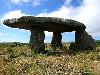
| Lanyon Quoit FeatureType : landmark Elevation : 188 Lat/Lng : 50.1474 / -5.599 | Lanyon Quoit is a dolmen in Cornwall, England, United Kingdom, 2 miles southeast of Morvah. It collapsed in a storm in 1815 and was re-erected 9 years later, and as a result the dolmen is now very different from its original appearance. (...) |
| 140 | 
| Egtved Girl FeatureType : landmark Elevation : 74 Lat/Lng : 55.6283 / 9.2825 | The Egtved Girl (c. 1390–1370 BC) was a Nordic Bronze Age girl whose well-preserved remains were discovered outside Egtved, Denmark in 1921. Aged 16–18 at death, she was slim, 160 cm tall (about 5 ft 3 in), had short, blond hair and well-trimmed nails. National Museum of Denmark (...) |
| 141 | Grand Canal (Ireland) FeatureType : river Elevation : 46 Lat/Lng : 53.3192 / -8.1997 | The Grand Canal is the southernmost of a pair of canals that connect Dublin, in the east of Ireland, with the River Shannon in the west, via Tullamore and a number of other villages and towns, the two canals nearly encircling Dublin's inner city (...) | |
| 142 | North Somerset FeatureType : adm2nd Elevation : 21 Lat/Lng : 51.3333 / -2.8333 | North Somerset is a unitary authority area in England. Its area covers part of the ceremonial county of Somerset but it is administered independently of the non-metropolitan county. Its administrative headquarters is in the town hall in Weston-super-Mare (...) | |
| 143 | 
| Ringsend FeatureType : city Elevation : 4 Lat/Lng : 53.3419 / -6.2264 | Ringsend is a southside inner suburb of Dublin, Ireland. It is located on the south bank of the River Liffey and east of the River Dodder, about two kilometres east of the city centre. It is the southern terminus of the East Link Toll Bridge (...) |
| 144 | Clarke County, Georgia FeatureType : adm2nd Elevation : 221 Lat/Lng : 33.9556 / -83.3831 | Clarke County is a county in the northeastern part of the U.S. state of Georgia. As of the 2010 census, the population was 116,714. Its county seat is Athens, with which it is a consolidated city-county. Clarke County is included in the Athens-Clarke County, GA Metropolitan Statistical Area, which (...) | |
| 145 | Franklin County, Georgia FeatureType : adm2nd Elevation : 235 Lat/Lng : 34.3833 / -83.2333 | Franklin County is a county located in the U.S. state of Georgia. As of the 2010 census, the population was 22,084. The county seat is Carnesville. On February 25, 1784 Franklin and Washington became Georgia's eighth and ninth counties, with Franklin named in honor of patriot Benjamin Franklin (...) | |
| 146 | Walton County, Georgia FeatureType : adm2nd Elevation : 244 Lat/Lng : 33.7833 / -83.7333 | Walton County is a county located in the U.S. state of Georgia. As of the 2010 census, the population was 83,768. The county seat is Monroe. Walton County is part of the Atlanta-Sandy Springs-Roswell, GA Metropolitan Statistical Area. (...) | |
| 147 | Wilkinson County, Mississippi FeatureType : adm2nd Elevation : 84 Lat/Lng : 31.16 / -91.32 | Wilkinson County is a county located in the U.S. state of Mississippi. As of the 2010 census, the population was 9,878. Its county seat is Woodville. The county is named for James Wilkinson, a Revolutionary War military leader and first governor of the Louisiana Territory after its acquisition by (...) | |
| 148 | 
| Gabriola Island FeatureType : isle Elevation : 138 Lat/Lng : 49.1663 / -123.8027 | Gabriola Island is one of the Gulf Islands in the Strait of Georgia in British Columbia (BC), Canada. It is about east of Nanaimo on Vancouver Island, to which it is linked by a 20-minute ferry service. It has a land area of about and a resident population of slightly over 4,000 (...) |
| 149 | Stonehenge, Avebury and Associated Sites FeatureType : landmark Elevation : 100 Lat/Lng : 51.1789 / -1.8253 | Stonehenge, Avebury and Associated Sites is a UNESCO World Heritage site located in Wiltshire, England. The WHS covers two large areas of land separated by nearly , rather than a specific monument or building. The sites were inscribed as co-listings in 1986 (...) | |
| 150 | Barrow Hill, Derbyshire FeatureType : null Elevation : 88 Lat/Lng : 53.2757 / -1.3731 | Barrow Hill is a village in Derbyshire north-east of the town of Chesterfield. The population of the village is included in the civil parish of Staveley. It was formerly the site of Barrow Hill railway station, and is also the site of Barrow Hill Engine Shed (...) | |
| 151 | Arctic Ocean FeatureType : waterbody Lat/Lng : 70.3256 / -148.7114 | The Arctic Ocean is the smallest and shallowest of the world's five major oceans. The International Hydrographic Organization (IHO) recognizes it as an ocean, although some oceanographers call it the Arctic Mediterranean Sea or simply the Arctic Sea, classifying it a mediterranean sea or an estuary (...) | |
| 152 | River Suir FeatureType : river Lat/Lng : 52.11 / -6.56 | The River Suir (; , Irish An tSiúr or Abhainn na Siúire) is a river in Ireland that flows into the Atlantic Ocean near Waterford after a distance of . River Suir, Ireland's Fisheries The catchment area of the Suir is 3,610 km2. Its long term average flow rate is 76 (...) | |
| 153 | Arraiolos FeatureType : adm1st Elevation : 334 Lat/Lng : 38.7 / -7.9667 | Arraiolos is a municipality in Évora District in Portugal. The population in 2011 was 7,363, in an area of 683.75 km². The town of Arraiolos has 3,351 inhabitants. The present Mayor is Silvia Pinto, elected by the Unitarian Democratic Coalition (...) | |
| 154 | Aberdeenshire FeatureType : adm2nd Elevation : 50 Lat/Lng : 57.151 / -2.123 | Aberdeenshire is one of the 32 council areas of Scotland. It takes its name from the County of Aberdeen which has substantially different boundaries. The Aberdeenshire council area includes all of the area of the historic counties of Aberdeenshire and Kincardineshire (except the area making up the (...) | |
| 155 | Lancashire FeatureType : adm1st Elevation : 27 Lat/Lng : 53.822 / -3.049 | Lancashire (; abbreviated Lancs.) is a ceremonial county in north west England. The administrative centre is Preston. The county has a population of 1,449,300 and an area of . People from Lancashire are known as Lancastrians. The history of Lancashire begins with its founding in the 12th century (...) | |
| 156 | Bolton FeatureType : null Elevation : 103 Lat/Lng : 53.5785 / -2.4299 | Bolton (locally) is a town in Greater Manchester in North West England. A former mill town, Bolton has been a production centre for textiles since Flemish weavers settled in the area in the 14th century, introducing a wool and cotton-weaving tradition (...) | |
| 157 | Ashford, Kent FeatureType : null Elevation : 42 Lat/Lng : 51.1465 / 0.8676 | Ashford is a town in the county of Kent, England. It lies on the River Great Stour at the south edge of the North Downs, about southeast of central London and northwest of Folkestone by road. In the 2011 census, it had a population of 74,204 (...) | |
| 158 | New Ross FeatureType : null Elevation : 7 Lat/Lng : 52.3956 / -6.9451 | New Ross (formerly Ros Mhic Treoin) is a town in southwest County Wexford, Ireland. It is located on the River Barrow, near the border with County Kilkenny, and is around 20 km north east of Waterford. In 2016 it had a population of 8,040 people, making it the fourth-largest town in the county. (...) | |
| 159 | 
| Piel Island FeatureType : isle Elevation : 8 Lat/Lng : 54.0639 / -3.175 | Piel Island lies half a mile (1 km) off the southern tip of the Furness Peninsula in the administrative county of Cumbria, though historically within Lancashire north of the sands. It is located at (OS grid ref. SD233637). It is one of the Islands of Furness (...) |
| 160 | Barrow Heights, Georgia FeatureType : city Elevation : 293 Lat/Lng : 33.9917 / -83.7444 | Barrow Heights is an unincorporated community located in Barrow County, Georgia, United States. (...) | |
| 161 | Coldrum Long Barrow FeatureType : null Elevation : 93 Lat/Lng : 51.3216 / 0.3727 | The Coldrum Long Barrow, also known as the Coldrum Stones and the Adscombe Stones, is a chambered long barrow located near the village of Trottiscliffe in the south-eastern English county of Kent. Probably constructed in the fourth millennium BCE, during Britain's Early Neolithic period, today it (...) | |
| 162 | Stoney Littleton Long Barrow FeatureType : landmark Elevation : 79 Lat/Lng : 51.3133 / -2.3817 | The Stoney Littleton Long Barrow (also known as the Bath Tumulus and the Wellow Tumulus) is a Neolithic chambered tomb with multiple burial chambers, located near the village of Wellow in the English county of Somerset (...) | |
| 163 | Northwest Passage FeatureType : null Lat/Lng : 74.3439 / -124.7697 | The Northwest Passage (NWP) is, from the European and northern Atlantic point of view, the sea route to the Pacific Ocean through the Arctic Ocean, along the northern coast of North America via waterways through the Canadian Arctic Archipelago (...) | |
| 164 | Grapevine, Texas FeatureType : city Elevation : 201 Lat/Lng : 32.935 / -97.0858 | Grapevine is a city and suburb of Dallas and Fort Worth located in northeast Tarrant County, Texas, United States, with minor portions extending into Dallas County and Denton County. The city is located in the Mid-Cities suburban region between Dallas and Fort Worth and includes a larger portion of (...) | |
| 165 | Saratov Oblast FeatureType : adm1st Elevation : 79 Lat/Lng : 51.7833 / 46.7333 | Saratov Oblast (Saratovskaya oblast) is a federal subject of Russia (an oblast), located in the Volga Federal District. Its administrative center is the city of Saratov. As of the 2010 Census, its population was 2,521,892. (...) | |
| 166 | County Laois FeatureType : adm1st Elevation : 115 Lat/Lng : 52.98 / -7.35 | County Laois is a county in Ireland. It is located in the south of the Midlands Region and is also located in the province of Leinster, and was formerly known as Queen's County. The modern county takes its name from Loígis, a medieval kingdom (...) | |
| 167 | River Mersey FeatureType : river Lat/Lng : 53.45 / -3.0333 | The River Mersey is a river in the North West of England. Its name is derived from the Anglo-Saxon language and translates as "boundary river". The river may have been the border between the ancient kingdoms of Mercia and Northumbria and for centuries it formed part of the boundary between the (...) | |
| 168 | London Borough of Hounslow FeatureType : adm1st Elevation : 25 Lat/Lng : 51.4676 / -0.3618 | The London Borough of Hounslow (pronunciation) is a London borough in West London, England, forming part of Outer London. It was created in 1965 when three smaller council areas amalgamated under the London Government Act 1963. It is governed by Hounslow London Borough Council (...) | |
| 169 | RFU Championship FeatureType : null Elevation : 30 Lat/Lng : 52.1337 / -0.4577 | The RFU Championship, known for sponsorship reasons as the Greene King IPA Championship from 2013–14, is the second tier of the English rugby union league system and was founded in September 1987. The twelve-side league was known as National Division One and in 2009 changed from semi-professional (...) | |
| 170 | Eastleigh F.C. FeatureType : landmark Elevation : 10 Lat/Lng : 50.9523 / -1.3718 | Eastleigh Football Club is a professional association football club based in Eastleigh, Hampshire, England. The club currently competes in and plays its home matches at Ten Acres. (...) | |
| 171 | Tristan da Cunha FeatureType : isle Elevation : 1659 Lat/Lng : -37.1167 / -12.2833 | Tristan da Cunha , colloquially Tristan, is both a remote group of volcanic islands in the south Atlantic Ocean and the main island of that group. It is the most remote inhabited archipelago in the world which lies proximately off the coast of Cape Town in South Africa, from Saint Helena and off the (...) | |
| 172 | Mendip Hills FeatureType : mountain Elevation : 267 Lat/Lng : 51.2686 / -2.6531 | The Mendip Hills (commonly called the Mendips) is a range of limestone hills to the south of Bristol and Bath in Somerset, England. Running east to west between Weston-super-Mare and Frome, the hills overlook the Somerset Levels to the south and the Chew Valley and other tributaries of the Avon to (...) | |
| 173 | West Coast Main Line FeatureType : null Elevation : 99 Lat/Lng : 52.178 / -0.924 | The West Coast Main Line (WCML) is one of the most important railway corridors in the United Kingdom, connecting the major cities of London, Birmingham, Liverpool, Manchester, and Glasgow. It is one of the busiest mixed-traffic railway routes in Europe, carrying a mixture of intercity rail, regional (...) | |
| 174 | Battle of Largs FeatureType : event Elevation : 7 Lat/Lng : 55.7926 / -4.8679 | The Battle of Largs (2 October 1263) was an indecisive engagement between the kingdoms of Norway and Scotland, on the Firth of Clyde near Largs, Scotland. The conflict formed part of the Norwegian expedition against Scotland in 1263, in which Haakon Haakonsson, King of Norway attempted to reassert (...) | |
| 175 | North Lincolnshire FeatureType : adm3rd Elevation : 22 Lat/Lng : 53.59 / -0.6 | North Lincolnshire is a unitary authority area in Lincolnshire, England, with a population of 167,446 at the 2011 census. There are three significant towns: Scunthorpe, the administrative centre, Brigg and Barton-upon-Humber (...) | |
| 176 | The Outlying Fells of Lakeland FeatureType : null Elevation : 217 Lat/Lng : 54.3205 / -2.7909 | The Outlying Fells of Lakeland is a book written by Alfred Wainwright, dealing with hills in and around the Lake District of England. It differs from Wainwright's Pictorial Guides in that each of its 56 chapters describes a walk, sometimes taking in several summits, rather than a single fell (...) | |
| 177 | Ravenglass FeatureType : city Elevation : 9 Lat/Lng : 54.3563 / -3.4101 | Ravenglass is a small coastal village and natural harbour in Cumbria, England roughly halfway between Barrow-in-Furness and Whitehaven. Historically in Cumberland, it is the only coastal town in the Lake District National Park. It is located at the estuary of three rivers: the Esk, Mite and Irt (...) | |
| 178 | Barrow, Illinois FeatureType : null Elevation : 194 Lat/Lng : 39.4947 / -90.4047 | Barrow is an unincorporated community located in Greene County, Illinois, United States outside Roodhouse, just off Rt. 106. (...) | |
| 179 | Parry Channel FeatureType : waterbody Lat/Lng : 74.3333 / -93.0 | The Parry Channel is a natural waterway through the central Canadian Arctic Archipelago. Its eastern two-thirds lies in the territory of Nunavut, while its western third (west of 110° West) lies in the Northwest Territories (...) | |
| 180 | South Derbyshire FeatureType : adm2nd Elevation : 93 Lat/Lng : 52.822 / -1.533 | South Derbyshire is a local government district in Derbyshire, England. The population of the local authority at the 2011 Census was 94,611. It contains a third of the National Forest, and the council offices are in Swadlincote (...) | |
| 181 | Furness Abbey FeatureType : landmark Elevation : 21 Lat/Lng : 54.1355 / -3.1983 | Furness Abbey, or St. Mary of Furness is a former monastery located to the north of Barrow-in-Furness, Cumbria, England. The abbey dates back to 1123 and was once the second-wealthiest and most powerful Cistercian monastery in the country, behind only Fountains Abbey in North Yorkshire. (...) | |
| 182 | 
| Manchester Grammar School FeatureType : edu Elevation : 49 Lat/Lng : 53.4486 / -2.2103 | Manchester Grammar School (MGS) is the largest independent day school for boys in the United Kingdom (ages 7–18) and is located in Manchester, England. Founded in 1515 as a free grammar school, it was formerly adjacent to Manchester Parish Church (later Manchester Cathedral) until 1931 when it moved (...) |
| 183 | 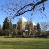
| David Dunlap Observatory FeatureType : landmark Elevation : 246 Lat/Lng : 43.863 / -79.4227 | The David Dunlap Observatory (DDO) is a large astronomical observatory site just north of Toronto in Richmond Hill, Ontario, housed on a estate. Formerly owned and operated by the University of Toronto from its establishment in 1935 until 2008, the observatory is now managed by the Royal (...) |
| 184 | Cape York Peninsula FeatureType : null Elevation : 14 Lat/Lng : -10.6833 / 142.5333 | Cape York Peninsula is a large remote peninsula located in Far North Queensland, Australia. It is the largest unspoiled wilderness in northern Australia.Mittermeier, R.E. et al. (2002). Wilderness: Earth’s last wild places. Mexico City: Agrupación Sierra Madre, S.C (...) | |
| 185 | Mount Washington (New Hampshire) FeatureType : landmark Elevation : 1908 Lat/Lng : 44.2705 / -71.3032 | Mount Washington, called Agiocochook by some Native American tribes, is the highest peak in the Northeastern United States at and the most topographically prominent mountain east of the Mississippi River. The mountain is notorious for its erratic weather (...) | |
| 186 | Wembley FeatureType : city Elevation : 43 Lat/Lng : 51.556 / -0.3042 | Wembley is an area of northwest London, England, and part of the London Borough of Brent. It is home to the Wembley Arena and Wembley Stadium. Wembley formed a separate civil parish from 1894 and was incorporated as a municipal borough in 1937 (...) | |
| 187 | Harlow FeatureType : city Elevation : 66 Lat/Lng : 51.779 / 0.128 | Harlow is a former Mark One New Town and local government district in the west of Essex, England. Situated on the border with Hertfordshire, it occupies a large area of land on the south bank of the upper Stort Valley, which has been made navigable through other towns and features a canal section (...) | |
| 188 | 
| New Forest FeatureType : landmark Elevation : 47 Lat/Lng : 50.8667 / -1.5833 | The New Forest is one of the largest remaining tracts of unenclosed pasture land, heathland and forest in the south-east of England, covering southwest Hampshire and southeast Wiltshire. It was proclaimed a royal forest by William the Conqueror, featuring in the Domesday Book (...) |
| 189 | Sheffield United F.C. FeatureType : landmark Elevation : 73 Lat/Lng : 53.3703 / -1.4708 | Sheffield United Football Club is a professional association football club based in the city of Sheffield, South Yorkshire, England. The team competes in the Championship, the second tier of English football. The football club was formed in 1889 as an offshoot of Sheffield United Cricket Club, and (...) | |
| 190 | Domestic pig FeatureType : landmark Elevation : 654 Lat/Lng : 38.2242 / 41.2417 | The domestic pig (Sus scrofa domesticus or only Sus domesticus), often called swine, hog, or simply pig when there is no need to distinguish it from other pigs, is a domesticated large, even-toed ungulate. It is variously considered a subspecies of the wild boar or a distinct species (...) | |
| 191 | May 4 FeatureType : null Lat/Lng : 38.4 / -27.0 | ==Events== *1256 – The Augustinian monastic order is constituted at the Lecceto Monastery when Pope Alexander IV issues a papal bull Licet ecclesiae catholicae. *1415 – Religious reformers John Wycliffe and Jan Hus are condemned as heretics at the Council of Constance (...) | |
| 192 | Alaska FeatureType : adm1st Lat/Lng : 61.2167 / -149.9 | Alaska is a U.S. state in the northwest extremity of North America. The Canadian administrative divisions of British Columbia and Yukon border the state to the east, its most extreme western part is Attu Island, and it has a maritime border with Russia (Chukotka Autonomous Okrug) to the west across (...) | |
| 193 | Hindpool FeatureType : adm3rd Elevation : 17 Lat/Lng : 54.117 / -3.2305 | Hindpool is an area and electoral ward of Barrow-in-Furness, Cumbria, England. It is bordered by Barrow Island, Central Barrow, Ormsgill, Parkside and the Walney Channel, the local population stood at 5,851 in 2011 (...) | |
| 194 | Millom FeatureType : null Elevation : 10 Lat/Lng : 54.21 / -3.2665 | Millom is a town and civil parish on the north shore of the estuary of the River Duddon around north of Barrow-in-Furness and south of Whitehaven in southwest Cumbria, England. Millom was constructed as a new town, beginning in 1866 and subsumed the village of Holborn Hill (...) | |
| 195 | Roman Catholic Diocese of Lancaster FeatureType : null Elevation : 11 Lat/Lng : 54.05 / -2.798 | The Roman Catholic Diocese of Lancaster is a Latin Church Roman Catholic diocese centred on Lancaster Cathedral in the city of Lancaster in Lancashire, England. (...) | |
| 196 | Athy FeatureType : city Elevation : 57 Lat/Lng : 52.992 / -6.987 | Athy is a market town at the meeting of the River Barrow and the Grand Canal in south-west County Kildare, Ireland, 72 kilometres southwest of Dublin. A population of 9,677 (as of the 2016 census) makes it the sixth largest town in Kildare and the 50th largest in the Republic of Ireland, with a (...) | |
| 197 | Glamorgan FeatureType : adm2nd Elevation : 265 Lat/Lng : 51.6667 / -3.6667 | Glamorgan , or sometimes Glamorganshire, (or) is one of the thirteen historic counties of Wales and a former administrative county of Wales. It was originally an early medieval petty kingdom of varying boundaries known as Glywysing until taken over by the Normans as a lordship (...) | |
| 198 | Selly Oak FeatureType : null Elevation : 155 Lat/Lng : 52.4387 / -1.9411 | Selly Oak is an industrial and residential area in south west Birmingham, England. The area gives its name to Selly Oak ward and includes the neighbourhoods of: Bournbrook, Selly Park, and Ten Acres. The adjoining wards of Edgbaston and Harborne are to the north of the Bourn Brook, which was the (...) | |
| 199 | A590 road FeatureType : null Elevation : 34 Lat/Lng : 54.249 / -3.0032 | The A590 is a trunk road in southern Cumbria, in the north-west of England. It runs north-east to south-west from M6 junction 36, through the towns of Ulverston and Barrow-in-Furness to terminate at Biggar Bank on Walney Island (...) | |
| 200 | Barrow Kunda FeatureType : city Elevation : 23 Lat/Lng : 13.4886 / -14.1169 | Barrow Kunda is a town in the Gambia. Barrow is the name of the Alkalo (village chief) and Kunda means compound. It is located in Wuli District in the Upper River Division. There is another Barrow Kunda located in Foni Kansala district which is not to be confused with this Barrow Kunda (...) | |
 by
by