| 627 records found in wikipedia | |||
| 1 | 
| Viti Levu  FeatureType : isle Elevation : 1117 Lat/Lng : -17.8 / 178.0 | Viti Levu (pronounced) is the largest island in the Republic of Fiji, the site of the nation's capital, Suva, and home to a large majority of Fiji's population. (...) |
| 2 | 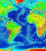
| Atlantic Ocean FeatureType : waterbody Lat/Lng : 0.0 / -25.0 | The Atlantic Ocean is the second largest of the world's oceans, with an area of about . It covers approximately 20 percent of the Earth's surface and about 29 percent of its water surface area. It separates the "Old World" from the "New World" (...) |
| 3 | 
| Lake Toba FeatureType : waterbody Elevation : 1574 Lat/Lng : 2.58 / 98.83 | Lake Toba is a large natural lake in Indonesia occupying the caldera of a supervolcano. The lake is about long, wide, and up to deep. Located in the middle of the northern part of the Indonesian island of Sumatra, with a surface elevation of about , the lake stretches from to (...) |
| 4 | 
| Tuamotus FeatureType : isle Lat/Lng : -18.0408 / -141.4094 | The Tuamotus, also referred to in English as the Tuamotu Archipelago or the Tuamotu Islands (, officially), are a French Polynesian chain of almost 80 islands and atolls forming the largest chain of atolls in the world (...) |
| 5 | 
| Otto Lilienthal FeatureType : landmark Elevation : 45 Lat/Lng : 52.4126 / 12.8203 | Otto Lilienthal (23 May 1848 – 10 August 1896) was a German pioneer of aviation who became known as the flying mane. g. New York Herald August 12th, 1896. He was the first person to make well-documented, repeated, successful flights with gliders (...) |
| 6 | 
| Chelyabinsk FeatureType : null Elevation : 250 Lat/Lng : 55.1547 / 61.3758 | Chelyabinsk is a city and the administrative center of Chelyabinsk Oblast, Russia, located in the northeast of the oblast, south of Yekaterinburg, just to the east of the Ural Mountains, on the Miass River, on the border of Europe and Asia. Population: (...) |
| 7 | 
| Tombstone, Arizona FeatureType : event Elevation : 1378 Lat/Lng : 31.7158 / -110.0647 | Tombstone is a historic city in Cochise County, Arizona, United States, founded in 1879 by prospector Ed Schieffelin in what was then Pima County, Arizona Territory. It became one of the last boomtowns in the American frontier (...) |
| 8 | 
| Azores FeatureType : isle Elevation : 20 Lat/Lng : 37.7411 / -25.6756 | The Azores (or ;), officially the Autonomous Region of the Azores , is one of the two autonomous regions of Portugal (along with Madeira (Região Autónoma da Madeira). It is an archipelago composed of nine volcanic islands in the North Atlantic Ocean about west of continental Portugal, about west of (...) |
| 9 | 
| Lafayette, Indiana FeatureType : null Elevation : 212 Lat/Lng : 40.4172 / -86.8786 | Lafayette (or lah-fee-YET) is a city in and the county seat of Tippecanoe County, Indiana, United States, located northwest of Indianapolis and southeast of Chicago. West Lafayette, on the other side of the Wabash River, is home to Purdue University, which contributes significantly to both (...) |
| 10 | 
| Herculaneum FeatureType : city Elevation : 23 Lat/Lng : 40.806 / 14.3482 | Located in the shadow of Mount Vesuvius, Herculaneum (Italian: Ercolano) was an ancient Roman town destroyed by volcanic pyroclastic flows in 79 AD. Its ruins are located in the comune of Ercolano, Campania, Italy (...) |
| 11 | 
| Aral Sea FeatureType : waterbody Elevation : 29 Lat/Lng : 44.8131 / 59.6153 | The Aral Sea https://en.oxforddictionaries.com/definition/aral_sea was an endorheic lake (one with no outflow) lying between Kazakhstan (Aktobe and Kyzylorda Regions) in the north and Uzbekistan (Karakalpakstan autonomous region) in the south (...) |
| 12 | 
| Caribbean Sea FeatureType : waterbody Lat/Lng : 15.5 / -74.66 | The Caribbean Sea is a sea of the Atlantic Ocean in the tropics of the Western Hemisphere. It is bounded by Mexico and Central America to the west and south west, to the north by the Greater Antilles starting with Cuba, to the east by the Lesser Antilles, and to the south by the north coast of South (...) |
| 13 | 
| Trans-Mexican Volcanic Belt FeatureType : null Elevation : 5566 Lat/Lng : 19.03 / -97.27 | The Trans-Mexican Volcanic Belt , also known as the Transvolcanic Belt and locally as the (Snowy Mountain Range), is a volcanic belt that covers central-southern Mexico. Several of its highest peaks have snow all year long, and during clear weather, they are visible to a large percentage of those (...) |
| 14 | 
| Giant's Causeway FeatureType : landmark Elevation : 2 Lat/Lng : 55.2408 / -6.5117 | The Giant's Causeway is an area of about 40,000 interlocking basalt columns, the result of an ancient volcanic fissure eruption. It is located in County Antrim on the north coast of Northern Ireland, about three miles (4.8 km) northeast of the town of Bushmills (...) |
| 15 | 
| Gainesville, Florida FeatureType : city Elevation : 37 Lat/Lng : 29.652 / -82.325 | Gainesville is the county seat and largest city in Alachua County, Florida, United States, and the principal city of the Gainesville, Florida Metropolitan Statistical Area (MSA). The population of Gainesville in the 2017 US Census estimates was 132,249, a 6.4% growth from 2010 (...) |
| 16 | 
| Mount St. Helens FeatureType : mountain Elevation : 2493 Lat/Lng : 46.1912 / -122.1944 | Mount St. Helens or Louwala-Clough (known as Lawetlat'la to the indigenous Cowlitz people, and Loowit to the Klickitat) is an active stratovolcano located in Skamania County, Washington, in the Pacific Northwest region of the United States (...) |
| 17 | 
| Mauna Loa FeatureType : mountain Elevation : 4133 Lat/Lng : 19.4795 / -155.6027 | Mauna Loa (or ; Hawaiian: ;) is one of five volcanoes that form the Island of Hawaii in the U.S. state of Hawaiʻi in the Pacific Ocean. The largest subaerial volcano in both mass and volume, Mauna Loa has historically been considered the largest volcano on Earth, dwarfed only by Tamu Massif (...) |
| 18 | 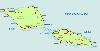
| Savai'i FeatureType : null Elevation : 1739 Lat/Lng : -13.625 / -172.4867 | Savaii is the largest (area 1,694 km2) and highest (Mt Silisili at 1,858 m) island in Samoa and the Samoan Islands chain. The island is the fifth largest in Polynesia, behind the two main islands of New Zealand and the Hawaiian Islands of Hawaii and Maui (...) |
| 19 | 
| Neanderthal FeatureType : landmark Elevation : 79 Lat/Lng : 51.2272 / 6.9444 | Neanderthals (also ;) Homo neanderthalensis or Homo sapiens neanderthalensis are an extinct species or subspecies of archaic humans in the genus Homo, who lived in Eurasia until 40,000 years ago. Currently earliest fossils of Neanderthals in Europe are dated between 430,000 to 450,000 years ago, and (...) |
| 20 | 
| Chile FeatureType : country Elevation : 543 Lat/Lng : -33.45 / -70.6667 | Chile , officially the Republic of Chile (RepChile.ogg), is a South American country occupying a long, narrow strip of land between the Andes to the east and the Pacific Ocean to the west. It borders Peru to the north, Bolivia to the northeast, Argentina to the east, and the Drake Passage in the far (...) |
| 21 | 
| Chernobyl disaster FeatureType : event Elevation : 149 Lat/Lng : 51.3896 / 30.0991 | The Chernobyl disaster, also referred to as the Chernobyl accident, was a catastrophic nuclear accident. It occurred on 25–26 April 1986 in the No. 4 light water graphite moderated reactor at the Chernobyl Nuclear Power Plant near the now-abandoned town of Pripyat, in northern Ukrainian Soviet (...) |
| 22 | 
| Iran FeatureType : country Elevation : 1188 Lat/Lng : 35.7 / 51.4167 | Iran , also known as Persia , officially the Islamic Republic of Iran , is a country in Western Asia. With over 81 million inhabitants, Iran is the world's 18th-most-populous country. Comprising a land area of , it is the second-largest country in the Middle East and the 17th-largest in the world (...) |
| 23 | 
| Victoria Falls FeatureType : landmark Elevation : 886 Lat/Lng : -17.9248 / 25.8579 | Victoria Falls (Lozi: Mosi-oa-Tunya, "The Smoke that Thunders") is a waterfall in southern Africa on the Zambezi River at the border between Zambia and Zimbabwe. (...) |
| 24 | 
| Faial Island FeatureType : null Elevation : 820 Lat/Lng : 38.5769 / -28.7028 | Faial Island , also known in English as Fayal, is a Portuguese island of the Central Group (Portuguese: Grupo Central) of the Azores. The Capelinhos Volcano, the westernmost point of the island, might as well be the westernmost point of Europe, if the Monchique Islet, near Flores Island, is (...) |
| 25 | 
| SS Edmund Fitzgerald FeatureType : landmark Elevation : 179 Lat/Lng : 46.9985 / -85.1102 | SS Edmund Fitzgerald was an American Great Lakes freighter that sank in a Lake Superior storm on November 10, 1975, with the loss of the entire crew of 29. When launched on June 7, 1958, she was the largest ship on North America's Great Lakes, and she remains the largest to have sunk there (...) |
| 26 | 
| Trump Tower FeatureType : landmark Elevation : 18 Lat/Lng : 40.7625 / -73.9742 | Trump Tower is a 58-story, mixed-use skyscraper at 721–725 Fifth Avenue between 56th and 57th Streets in Midtown Manhattan, New York City. Trump Tower serves as the headquarters for The Trump Organization. Additionally, it houses the penthouse condominium residence of the building's namesake and (...) |
| 27 | 
| Prince Edward Island FeatureType : adm1st Elevation : 13 Lat/Lng : 46.2354 / -63.1265 | Prince Edward Island (PEI or P.E.I.;) is a province of Canada consisting of the island of the same name, and several much smaller islands. Prince Edward Island is one of the three Maritime Provinces and is the smallest province in both land area and population (...) |
| 28 | 
| TWA Flight 800 FeatureType : event Lat/Lng : 40.6503 / -72.6333 | Trans World Airlines Flight 800 (TWA 800) was a Boeing 747-100 that exploded and crashed into the Atlantic Ocean near East Moriches, New York, on July 17, 1996, at about 8:31 p.m. EDT, 12 minutes after takeoff from John F (...) |
| 29 | 
| Lascar (volcano) FeatureType : mountain Elevation : 5558 Lat/Lng : -23.3672 / -67.7281 | Lascar is a stratovolcano within the Central Volcanic Zone of the Andes, a volcanic arc that spans the countries of Peru, Bolivia, Argentina and Chile. It is the most active volcano in the region, with records of eruptions going back to 1848 (...) |
| 30 | 
| Hot Springs National Park FeatureType : null Elevation : 216 Lat/Lng : 34.5142 / -93.0522 | Hot Springs National Park is an American national park in central Garland County, Arkansas, adjacent to the city of Hot Springs, the county seat. Hot Springs Reservation was initially created by an act of the United States Congress on April 20, 1832 to be preserved for future recreation (...) |
| 31 | 
| Walt Disney Concert Hall FeatureType : landmark Elevation : 117 Lat/Lng : 34.0553 / -118.25 | The Walt Disney Concert Hall at 111 South Grand Avenue in downtown Los Angeles, California, is the fourth hall of the Los Angeles Music Center and was designed by Frank Gehry. It opened on October 24, 2003. Bounded by Hope Street, Grand Avenue, and 1st and 2nd Streets, it seats 2,265 people and (...) |
| 32 | Mendocino Fracture Zone FeatureType : landmark Lat/Lng : 40.4167 / -125.0 | The Mendocino Fracture Zone is a fracture zone and transform boundary off the coast of Cape Mendocino in far northern California. It runs westward from a triple junction with the San Andreas Fault and the Cascadia subduction zone to the southern end of the Gorda Ridge (...) | |
| 33 | 
| Geography of Portugal FeatureType : country Elevation : 75 Lat/Lng : 39.3705 / -8.1403 | Portugal is a coastal nation in southwestern Europe, located at the western end of the Iberian Peninsula, bordering Spain (on its northern and eastern frontiers: a total of). The Portuguese territory also includes a series of archipelagos in the Atlantic Ocean (the Açores and Madeira), which are (...) |
| 34 | 
| Eschede derailment FeatureType : event Elevation : 79 Lat/Lng : 52.7344 / 10.2202 | The Eschede derailment occurred on 3 June 1998, near the village of Eschede in the Celle district of Lower Saxony, Germany, when a high-speed train derailed and crashed into a road bridge. 101 people were killed and around 100 were injured (...) |
| 35 | 
| St. Francis Dam FeatureType : landmark Elevation : 517 Lat/Lng : 34.547 / -118.5126 | The St. Francis Dam was a curved concrete gravity dam, built to create a large regulating and storage reservoir for the city of Los Angeles, California. The reservoir was an integral part of the city's Los Angeles Aqueduct water supply infrastructure (...) |
| 36 | 
| Bodø Airport FeatureType : airport Lat/Lng : 67.2692 / 14.3653 | Bodø Airport is a civil airport in Bodø, Norway. Located just south of the city centre, on the westernmost tip of the Bodø-peninsula, it shares facilities with the military air force base Bodø Main Air Station. The airport has a single concrete, runway which runs in a roughly east-west direction (...) |
| 37 | 
| Terry Fox FeatureType : null Elevation : 2502 Lat/Lng : 52.9333 / -119.2333 | Terrance Stanley "Terry" Fox (July 28, 1958 June 28, 1981) was a Canadian athlete, humanitarian, and cancer research activist. In 1980, with one leg having been amputated due to cancer, he embarked on an east to west cross-Canada run to raise money and awareness for cancer research (...) |
| 38 | 
| Rogue wave FeatureType : null Lat/Lng : 58.1887 / 2.4667 | Rogue waves (also known as freak waves, monster waves, episodic waves, killer waves, extreme waves, and abnormal waves) are large, unexpected and suddenly appearing surface waves that can be extremely dangerous, even to large ships such as ocean liners (...) |
| 39 | Mid-Atlantic Ridge FeatureType : null Lat/Lng : 71.1 / -8.2 | The Mid-Atlantic Ridge (MAR) is a mid-ocean ridge, a divergent tectonic plate or constructive plate boundary located along the floor of the Atlantic Ocean, and part of the longest mountain range in the world. In the North Atlantic it separates the Eurasian and North American plates, and in the South (...) | |
| 40 | Panzhihua FeatureType : adm2nd Elevation : 1175 Lat/Lng : 26.5817 / 101.7183 | Panzhihua is a prefecture-level city located in the far south of Sichuan province, People's Republic of China, at the confluence of the Jinsha and Yalong Rivers. It has an administrative area of , and a population at the 2010 census of 1,214,121 (...) | |
| 41 | 
| Sidoarjo mud flow FeatureType : landmark Elevation : 4 Lat/Lng : -7.5261 / 112.7109 | The Sidoarjo mud flow or Lapindo mud (informally abbreviated as Lusi, a contraction of Lumpur Sidoarjo wherein lumpur is the Indonesian word for mud) is the result of an erupting mud volcano in the subdistrict of Porong, Sidoarjo in East Java, Indonesia that has been in eruption since May 2006 (...) |
| 42 | Earthquake FeatureType : null Lat/Lng : -38.24 / 73.05 | An earthquake (also known as a quake, tremor or temblor) is the shaking of the surface of the Earth, resulting from the sudden release of energy in the Earth's lithosphere that creates seismic waves. Earthquakes can range in size from those that are so weak that they cannot be felt to those violent (...) | |
| 43 | Hydraulic fracturing FeatureType : null Elevation : 38 Lat/Lng : 53.0708 / 9.622 | Hydraulic fracturing (also fracking, fraccing, frac'ing, hydrofracturing or hydrofracking) is a well stimulation technique in which rock is fractured by a pressurized liquid. The process involves the high-pressure injection of 'fracking fluid' (primarily water, containing sand or other proppants (...) | |
| 44 | 
| Tonga Trench FeatureType : waterbody Lat/Lng : -22.9447 / -174.7331 | The Tonga Trench is an oceanic trench located in the south-west Pacific Ocean. It is the deepest trench of the Southern Hemisphere and the second deepest on Earth. The fastest plate tectonic velocity on Earth occurs as the Pacific Plate is being subducted westward in the trench (...) |
| 45 | Central Eastern Alps FeatureType : mountain Elevation : 3941 Lat/Lng : 46.3824 / 9.9081 | The Central Eastern Alps , also referred to as Austrian Central Alps or just Central AlpsNot to be confused with the other meaning of Central Alps i.e. the Swiss Alps. comprise the main chain of the Eastern Alps in Austria and the adjacent regions of Switzerland, Liechtenstein, Italy and Slovenia (...) | |
| 46 | Herceg Novi FeatureType : city Elevation : 33 Lat/Lng : 42.453 / 18.5312 | Herceg Novi (Montenegrin Cyrillic: Херцег Нови;) is a coastal town in Montenegro located at the entrance to the Bay of Kotor and at the foot of Mount Orjen. It is the administrative center of the Herceg Novi Municipality with around 33,000 inhabitants (...) | |
| 47 | Philippine Sea FeatureType : waterbody Lat/Lng : 17.7 / 133.7 | The Philippine Sea is a marginal sea east and northeast of the Philippines occupying an estimated surface area of . The Philippine Sea Plate forms the floor of the sea, which forms a portion of the western North Pacific Ocean (...) | |
| 48 | Yosemite National Park FeatureType : null Elevation : 1228 Lat/Lng : 37.7486 / -119.5872 | Yosemite National Park is an American national park located in the western Sierra Nevada of Central California, bounded on the southeast by Sierra National Forest and on the northwest by Stanislaus National Forest (...) | |
| 49 | Charlie-Gibbs Fracture Zone FeatureType : null Lat/Lng : 52.5 / -31.75 | Charlie-Gibbs Fracture Zone is a system of two parallel fracture zones. It is the most prominent interruption of the Mid-Atlantic Ridge between the Azores and Iceland. It can be traced over more than 2000 kilometers, all the way from north-east of Newfoundland to south-west of Ireland (...) | |
| 50 | 2008 Sichuan earthquake FeatureType : null Elevation : 2338 Lat/Lng : 31.015 / 103.365 | The 2008 Sichuan earthquakeSome early Western reports used the term Chengdu quake; e.g., , , etc. This term never picked up widely in media reports, but was reportedly used by BBC America in a follow-up report on preparations for winter and housing rebuilding efforts aired November 12, 2008, in (...) | |
| 51 | Central Indian Ridge FeatureType : landmark Lat/Lng : -34.6555 / 54.4828 | The Central Indian Ridge (CIR) is a north-south-trending mid-ocean ridge in the western Indian Ocean. (...) | |
| 52 | UEFA Women's Euro 2009 FeatureType : landmark Lat/Lng : 60.1667 / 24.9333 | The 2009 UEFA Women's Championship, or just Women's Euro 2009, was played in Finland between August 23 and September 10, 2009. The host was appointed on July 11, 2006, in a UEFA Executive Committee meeting in Berlin and the Finnish proposal won over the Dutch proposal (...) | |
| 53 | 
| Ducie Island FeatureType : null Lat/Lng : -24.6833 / -124.7833 | Ducie Island is an uninhabited atoll in the Pitcairn Islands. It lies east of Pitcairn Island, and east of Henderson Island, and has a total area of , which includes the lagoon. It is long, measured northeast to southwest, and about wide (...) |
| 54 | Breitach FeatureType : null Elevation : 784 Lat/Lng : 47.4273 / 10.274 | The Breitach is a 24 km long mountain river, the southwestern (left) source of the Iller in the Allgäu Alps, in the states of Vorarlberg (Austria) and Bavaria (Germany). (...) | |
| 55 | 1980 eruption of Mount St. Helens FeatureType : event Elevation : 2114 Lat/Lng : 46.2003 / -122.1867 | On May 18, 1980, a major volcanic eruption occurred at Mount St. Helens, a volcano located in Skamania County, in the U.S. state of Washington. The eruption (a VEI 5 event) was the most significant volcanic eruption to occur in the contiguous 48 U.S (...) | |
| 56 | Glacier FeatureType : waterbody Elevation : 39 Lat/Lng : -46.689 / -73.848 | A glacier (or) is a persistent body of dense ice that is constantly moving under its own weight; it forms where the accumulation of snow exceeds its ablation (melting and sublimation) over many years, often centuries (...) | |
| 57 | TaskForceMajella FeatureType : null Elevation : 938 Lat/Lng : 42.03 / 14.03 | The TaskForceMajella (TFM) is an industry-funded geoscientific research project conducted between the years 1998 and 2005. The project involved numerous universities distributed worldwide, and was sponsored by a number of international major oil companies (...) | |
| 58 | Rocky Mountains FeatureType : null Elevation : 4118 Lat/Lng : 43.7412 / -110.8024 | The Rocky Mountains, also known as the Rockies, are a major mountain range in western North America. The Rocky Mountains stretch more than from the northernmost part of British Columbia, in western Canada, to New Mexico, in the Southwestern United States (...) | |
| 59 | Bidar FeatureType : city Elevation : 672 Lat/Lng : 17.9074 / 77.5271 | Bidar is a hill top city in the north-eastern part of Karnataka state in south India. It is the headquarters of the Bidar which borders Maharashtra and Telangana. It is a rapidly urbanising city in the wider Bidar Metropolitan area (...) | |
| 60 | Bavarian Forest FeatureType : mountain Elevation : 412 Lat/Lng : 49.0 / 12.6667 | The Bavarian Forest (German: Bayerischer Wald or Bayerwald) is a wooded, low-mountain region in Bavaria, Germany that is about 100 kilometres long. It runs along the Czech border and is continued on the Czech side by the Bohemian Forest (Czech: Šumava) (...) | |
| 61 | Abebe Bikila FeatureType : null Elevation : 2289 Lat/Lng : 8.9699 / 38.7671 | Abebe Bikila (; August 7, 1932 – October 25, 1973) was an Ethiopian double Olympic marathon champion. He won the marathon at the 1960 Summer Olympics in Rome while running barefoot, setting a world record. At the 1964 Summer Olympics in Tokyo, Abebe was the first athlete to successfully defend an (...) | |
| 62 | Phobos (moon) FeatureType : null Lat/Lng : 60.0 / -91.0 | Phobos (http://www.oxforddictionaries.com/us/definition/english/phobos?q=Phobos ; systematic designation:) is the innermost and larger of the two natural satellites of Mars, the other being Deimos. Both moons were discovered in 1877 by American astronomer Asaph Hall (...) | |
| 63 | Track (rail transport) FeatureType : landmark Elevation : 530 Lat/Lng : 48.1484 / 11.4616 | The track on a railway or railroad, also known as the permanent way, is the structure consisting of the rails, fasteners, railroad ties (sleepers, British English) and ballast (or slab track), plus the underlying subgrade (...) | |
| 64 | Vanua Levu FeatureType : isle Elevation : 278 Lat/Lng : -16.5833 / 179.1833 | Vanua Levu (pronounced), formerly known as Sandalwood Island, is the second largest island of Fiji. Located to the north of the larger Viti Levu, the island has an area of and a population of 135,961 . (...) | |
| 65 | 
| Joint Security Area FeatureType : landmark Elevation : 26 Lat/Lng : 37.956 / 126.6769 | The Joint Security Area (JSA) is the only portion of the Korean Demilitarized Zone (DMZ) where North and South Korean forces stand face-to-face. It is often called the Truce Village of Panmunjom (the Truce Village; or simply, Panmunjom) in the media and various military accounts (...) |
| 66 | Odenwald FeatureType : mountain Elevation : 560 Lat/Lng : 49.584 / 9.0218 | The Odenwald is a low mountain range in the German states of Hesse, Bavaria and Baden-Württemberg. (...) | |
| 67 | Grace Kelly FeatureType : landmark Elevation : 74 Lat/Lng : 40.0182 / -75.1892 | Grace Patricia Kelly (November 12, 1929September 14, 1982) was an American film actress who became Princess of Monaco after marrying Prince Rainier III in April 1956. After embarking on an acting career in 1950, when she was 20, Kelly appeared in New York City theatrical productions and more than 40 (...) | |
| 68 | Western Norway FeatureType : adm1st Lat/Lng : 60.8878 / 6.7236 | Western Norway is the region along the Atlantic coast of southern Norway. It consists of the counties Rogaland, Hordaland, Sogn og Fjordane, and Møre og Romsdal. The region has a population of approximately 1.3 million people. The largest city is Bergen and the second-largest is Stavanger (...) | |
| 69 | Fault (geology) FeatureType : null Elevation : 1841 Lat/Lng : 40.26 / 77.66 | In geology, a fault is a planar fracture or discontinuity in a volume of rock, across which there has been significant displacement as a result of rock-mass movement. Large faults within the Earth's crust result from the action of plate tectonic forces, with the largest forming the boundaries (...) | |
| 70 | 
| Cro-Magnon rock shelter FeatureType : landmark Elevation : 73 Lat/Lng : 44.9403 / 1.0097 | Cro-Magnon French abri means "rock shelter", crô means "hole" in Occitan (standard French creux), and Magnon is the surname of the land owner at the time. is an Aurignacian (Upper Paleolithic) site, located in a rock shelter at Les Eyzies, a hamlet in the commune of Les Eyzies-de-Tayac-Sireuil, (...) |
| 71 | Hero Fracture Zone FeatureType : landmark Lat/Lng : -61.5 / -66.0 | The Hero Fracture Zone is an undersea fracture zone in the Antarctic. Its name was approved by the Advisory Committee on Undersea Features in June 1987. (...) | |
| 72 | Scotia Plate FeatureType : null Lat/Lng : -57.0 / -46.0 | The Scotia Plate is a tectonic plate on the edge of the South Atlantic and Southern Ocean. Thought to have formed during the early Eocene with the opening of the Drake Passage that separates South America from Antarctica, it is a minor plate whose movement is largely controlled by the two major (...) | |
| 73 | Falklands War FeatureType : null Lat/Lng : -51.7333 / -59.4167 | The Falklands War , also known as the Falklands Conflict, Falklands Crisis, Malvinas War, South Atlantic Conflict, and the Guerra del Atlántico Sur (Spanish for "South Atlantic War"), was a ten-week war between Argentina and the United Kingdom over two British dependent territories in the South (...) | |
| 74 | Castile and León FeatureType : adm1st Elevation : 761 Lat/Lng : 41.3833 / -4.45 | Castile and León (; ; Leonese: Castiella y Llión ;) is an autonomous community in north-western Spain. It was constituted in 1983, although it existed for the first time during the First Spanish Republic in the 19th century (...) | |
| 75 | Angoulême FeatureType : null Elevation : 93 Lat/Lng : 45.6489 / 0.1608 | Angoulême (; Poitevin-Saintongeais: Engoulaeme;) is a commune, the capital of the Charente department, in the Nouvelle-Aquitaine region of southwestern France. The inhabitants of the commune are known as Angoumoisins or Angoumoisines (...) | |
| 76 | Washington Redskins FeatureType : null Elevation : 69 Lat/Lng : 37.564 / -77.465 | The Washington Redskins are a professional American football team based in the Washington metropolitan area. The Redskins compete in the National Football League (NFL) as a member of the National Football Conference (NFC) East division (...) | |
| 77 | Wernher von Braun FeatureType : landmark Elevation : 1159 Lat/Lng : 47.5156 / 10.4008 | Wernher Magnus Maximilian Freiherr von Braun (March 23, 1912 – June 16, 1977) was a German (and, later, American) aerospace engineer and space architect. He was the leading figure in the development of rocket technology in Germany and the father of rocket technology and space science in the United (...) | |
| 78 | Ronald Reagan FeatureType : null Elevation : 359 Lat/Lng : 34.259 / -118.8204 | Ronald Wilson Reagan (; February 6, 1911June 5, 2004) was an American politician and actor who served as the 40th President of the United States from 1981 to 1989. Prior to the presidency, he was a Hollywood actor and trade union leader before serving as the 33rd Governor of California from 1967 to (...) | |
| 79 | 2008 U.S. Open (golf) FeatureType : null Elevation : 114 Lat/Lng : 32.904 / -117.246 | The 2008 United States Open Championship was the 108th U.S. Open, played June 12–16 at Torrey Pines in La Jolla, California, north of San Diego. Tiger Woods won his third U.S. Open and 14th major title, defeating Rocco Mediate on the first hole of sudden-death, following an 18-hole With this (...) | |
| 80 | 
| Stawamus Chief FeatureType : mountain Elevation : 638 Lat/Lng : 49.6857 / -123.1394 | The Stawamus Chief, officially Stawamus Chief Mountain (often referred to as simply The Chief, or erroneously as the Squamish Chief), is a granite dome located adjacent to the town of Squamish, British Columbia, Canada. It towers over above the waters of nearby Howe Sound (...) |
| 81 | Shanidar Cave FeatureType : landmark Elevation : 457 Lat/Lng : 36.8006 / 44.2433 | Shanidar Cave Şaneder or Zewî Çemî Şaneder;) is an archaeological site located on Bradost Mountain in the Erbil Governorate of Iraq. The remains of ten Neanderthals, dating from 35,000 to 65,000 years ago, have been found within the cave (...) | |
| 82 | 
| Home, Washington FeatureType : city Elevation : 43 Lat/Lng : 47.2769 / -122.7661 | Home is a census-designated place in Pierce County, Washington, United States. The 2010 Census placed the population at 1,377. The community lies on the Key Peninsula and borders the waters of Carr Inlet, an extension of Puget Sound (...) |
| 83 | 
| Kurobe Dam FeatureType : landmark Elevation : 1427 Lat/Lng : 36.5664 / 137.6614 | The or , is a variable-radius arch dam on the Kurobe River in Toyama Prefecture, Japan. It supports the 335 MW Kurobe No. 4 Hydropower Plant and is owned by Kansai Electric Power Company. At in height, it is the tallest dam in Japan. It was constructed between 1956 and 1963 at a cost of ¥51 (...) |
| 84 | 
| Geography of the Faroe Islands FeatureType : null Lat/Lng : 62.0 / -7.0 | The Faroe Islands are an island group consisting of eighteen islands between the Norwegian Sea and the North Atlantic, about half-way between Iceland and Norway. Its coordinates are . It is 1,393 square kilometres in area, and includes small lakes and rivers, but no major ones (...) |
| 85 | Indian Plate FeatureType : landmark Lat/Lng : 3.316 / 95.854 | The Indian Plate or India Plate is a major tectonic plate straddling the equator in the eastern hemisphere. Originally a part of the ancient continent of Gondwana, India broke away from the other fragments of Gondwana and began moving north (...) | |
| 86 | Fox River (Illinois River tributary) FeatureType : waterbody Elevation : 175 Lat/Lng : 42.7336 / -87.7784 | The Fox River is a U.S. Geological Survey. National Hydrography Dataset high-resolution flowline data. , accessed May 13, 2011 tributary of the Illinois River, flowing from southeastern Wisconsin to Ottawa, Illinois in the United States (...) | |
| 87 | Selters (Taunus) FeatureType : null Elevation : 250 Lat/Lng : 50.3418 / 8.2437 | Selters (Taunus) is a community with 8,000 inhabitants north of Bad Camberg in Limburg-Weilburg district in Hesse, Germany. (...) | |
| 88 | 
| Washington Avenue Bridge (Minneapolis) FeatureType : null Elevation : 221 Lat/Lng : 44.9731 / -93.2393 | The Washington Avenue Bridge carries County Road 122 and the METRO Green Line light rail across the Mississippi River in Minneapolis, Minnesota and connects the East Bank and West Bank portions of the University of Minnesota's main campus (...) |
| 89 | Assassination of Benazir Bhutto FeatureType : null Elevation : 496 Lat/Lng : 33.6073 / 73.0633 | The assassination of Benazir Bhutto took place on 27 December 2007 in Rawalpindi, Pakistan. Benazir Bhutto, twice Prime Minister of Pakistan (1988–1990; 1993–1996) and then-leader of the opposition Pakistan Peoples Party, had been campaigning ahead of elections scheduled for January 2008 (...) | |
| 90 | Farmington, New Mexico FeatureType : city Elevation : 1666 Lat/Lng : 36.7517 / -108.1897 | Farmington (Tóta) is a city in San Juan County in the U.S. state of New Mexico. As of the 2013 population estimate from the United States Census Bureau the city had a total population of 45,426 people. Farmington (and surrounding San Juan County) makes up one of the four Metropolitan Statistical (...) | |
| 91 | Cherrapunji FeatureType : null Elevation : 1369 Lat/Lng : 25.2792 / 91.7242 | Cherrapunji (; with the native name Sohra being more commonly used, and can also be spelled Cherrapunjee or Cherrapunji) is a subdivisional town in the East Khasi Hills district in the Indian state of Meghalaya (...) | |
| 92 | 
| Geography of Nicaragua FeatureType : country Elevation : 130 Lat/Lng : 13.0 / -85.0 | Nicaragua (officially the Republic of Nicaragua) is a country in Central America, bordering both the Caribbean Sea and the North Pacific Ocean, between Costa Rica and Honduras. Nicaragua is the largest country in Central America (...) |
| 93 | 
| Goblin Valley State Park FeatureType : null Elevation : 1501 Lat/Lng : 38.5423 / -110.7212 | Goblin Valley State Park is a state park of Utah, in the United States. Its eminent feature is its thousands of hoodoos and hoodoo rocks, referred to locally as "goblins", which are formations of mushroom-shaped rock pinnacles, some as high as several meters (...) |
| 94 | Mount Edziza volcanic complex FeatureType : mountain Elevation : 2712 Lat/Lng : 57.7156 / -130.6344 | The Mount Edziza volcanic complex is a large and potentially active north-south trending complex volcano in Stikine Country, northwestern British Columbia, Canada, located southeast of the small community of Telegraph Creek (...) | |
| 95 | East African Rift FeatureType : null Elevation : 1329 Lat/Lng : -3.0 / 35.5 | The East African Rift (EAR) is an active continental rift zone in East Africa. The EAR began developing around the onset of the Miocene, 22–25 million years ago. In the past, it was considered to be part of a larger Great Rift Valley that extended north to Asia Minor (...) | |
| 96 | Liberty ship FeatureType : null Elevation : 6 Lat/Lng : 57.7867 / -152.405 | Liberty ships were a class of cargo ship built in the United States during World War II. Though British in conception, the design was adapted by the United States for its simple, low-cost construction. Mass-produced on an unprecedented scale, the Liberty ship came to symbolize U.S (...) | |
| 97 | 
| Geothermal areas of Yellowstone FeatureType : null Elevation : 2060 Lat/Lng : 44.9669 / -110.7122 | The geothermal areas of Yellowstone include several geyser basins in Yellowstone National Park as well as other geothermal features such as hot springs, mud pots, and fumaroles. The number of thermal features in Yellowstone is estimated at 10,000 (...) |
| 98 | Shillong Plateau FeatureType : null Elevation : 1303 Lat/Lng : 25.5833 / 92.0 | The Shillong Plateau is a plateau in eastern Meghalaya state, northeastern India. The plateau's southern, northern and western ridges form the Garo, Khasi and Jaintia Hills respectively. The plateau shows numerous fracture lineaments in satellite images and has been subjected to extensive and (...) | |
| 99 | Balleny Islands FeatureType : null Lat/Lng : -66.9167 / 163.75 | The Balleny Islands are a series of uninhabited islands in the Southern Ocean extending from 66°15' to 67°35'S and 162°30' to 165°00'E. The group extends for about in a northwest-southeast direction. The islands are heavily glaciated and of volcanic origin (...) | |
| 100 | 2012 Indian Ocean earthquakes FeatureType : event Lat/Lng : 2.311 / 93.063 | The 2012 Indian Ocean earthquakes were magnitude 8.6 and 8.2 Mw undersea earthquakes that struck near the Indonesian province of Aceh on 11 April at 15:38 local time. Initially, authorities feared that the initial earthquake would cause a tsunami and warnings were issued across the Indian Ocean; (...) | |
| 101 | Villarrica (volcano) FeatureType : mountain Elevation : 2827 Lat/Lng : -39.4202 / -71.9404 | Villarrica is one of Chile's most active volcanoes, rising above the lake and town of the same name, south of Santiago. It is also known as Rucapillán, a Mapuche word meaning "devil's house". It is the westernmost of three large stratovolcanoes that trend NW-SW obliquely perpendicular to the Andean (...) | |
| 102 | Michigan International Speedway FeatureType : landmark Elevation : 301 Lat/Lng : 42.0663 / -84.2414 | Michigan International Speedway (MIS) is a moderate-banked D-shaped speedway located off U.S. Highway 12 on more than approximately south of the village of Brooklyn, in the scenic Irish Hills area of southeastern Michigan. The track is used primarily for NASCAR events (...) | |
| 103 | Macau Grand Prix FeatureType : landmark Elevation : 28 Lat/Lng : 22.1928 / 113.5531 | The Macau Grand Prix is a motorsport road race for automobiles and motorcycles held annually in Macau. It is the only street circuit racing event in which both cars and motorcycles participate. The first Macau Grand Prix event was held in 1954, as a sports car event (...) | |
| 104 | Samoan Islands FeatureType : country Lat/Lng : -14.2667 / -171.2 | The Samoan Islands are an archipelago covering in the central South Pacific, forming part of Polynesia and the wider region of Oceania. Administratively, the archipelago comprises all of Samoa and most of American Samoa (apart from Swains Island, which is part of the Tokelau Islands) (...) | |
| 105 | Autodromo Enzo e Dino Ferrari FeatureType : landmark Elevation : 40 Lat/Lng : 44.3422 / 11.7143 | The Autodromo Internazionale Enzo e Dino Ferrari is a motorsport race circuit near the Italian town of Imola, east of Bologna and east of the Ferrari factory in Maranello. The circuit is named after Ferrari's late founder Enzo and his son Dino who had died in the 1950s (...) | |
| 106 | Oldowan FeatureType : landmark Elevation : 937 Lat/Lng : 36.2009 / 5.6544 | The Oldowan (or Mode I) is the earliest widespread stone tool archaeological industry (style) in prehistory. These early tools were simple, usually made with one or a few flakes chipped off with another stone. Oldowan tools were used during the Lower Paleolithic period, 2 (...) | |
| 107 | United States Naval Research Laboratory FeatureType : landmark Elevation : 7 Lat/Lng : 38.8239 / -77.0225 | The United States Naval Research Laboratory (NRL) is the corporate research laboratory for the United States Navy and the United States Marine Corps. It conducts basic scientific research, applied research, technological development and prototyping (...) | |
| 108 | 1992 Cape Mendocino earthquakes FeatureType : null Elevation : 30 Lat/Lng : 37.78 / -122.42 | The 1992 Cape Mendocino earthquakes (or 1992 Petrolia earthquakes) occurred along the Lost Coast of Northern California on April 25 and 26. The three largest events were the M7.2 thrust mainshock that struck near the unincorporated community of Petrolia midday on April 25 and two primary strike-slip (...) | |
| 109 | Sierra de las Quijadas National Park FeatureType : landmark Elevation : 746 Lat/Lng : -32.5508 / -67.0642 | The Sierra de las Quijadas National Park is a national park located in the northwestern part of the Argentine province of San Luis. It was established on December 10, 1991, to protect the natural features, representative of the Semiarid Chaco and the Argentine Low Monte ecoregions. (...) | |
| 110 | First Portuguese Republic FeatureType : country Elevation : 13 Lat/Lng : 38.7 / -9.1833 | The First Portuguese Republic (; officially: República Portuguesa, Portuguese Republic) spans a complex 16-year period in the history of Portugal, between the end of the period of constitutional monarchy marked by the 5 October 1910 revolution and the 28 May coup d'état of 1926 (...) | |
| 111 | Battle of Stamford Bridge FeatureType : event Elevation : 16 Lat/Lng : 53.989 / -0.903 | The Battle of Stamford Bridge took place at the village of Stamford Bridge, East Riding of Yorkshire, in England on 25 September 1066, between an English army under King Harold Godwinson and an invading Norwegian force led by King Harald Hardrada and the English king's brother Tostig Godwinson (...) | |
| 112 | Hérouxville FeatureType : null Elevation : 143 Lat/Lng : 46.6668 / -72.6158 | Hérouxville (the previous designation was "Saint-Timothée d'Hérouxville") is a parish municipality in the Mékinac Regional County Municipality in the administrative region of Mauricie, in the province of Quebec, Canada. Its watershed is mainly part of the Batiscanie (...) | |
| 113 | Puyehue-Cordón Caulle FeatureType : mountain Elevation : 1898 Lat/Lng : -40.5824 / -72.1156 | Puyehue and Cordón Caulle are two coalesced volcanic edifices that form a major mountain massif in Puyehue National Park in the Andes of Ranco Province, in the South of Chile. In volcanology this group is known as the Puyehue-Cordón Caulle Volcanic Complex (PCCVC) (...) | |
| 114 | Weslaco, Texas FeatureType : city Elevation : 26 Lat/Lng : 26.1592 / -97.9875 | Weslaco is a city in Hidalgo County, Texas, United States. As of the 2010 census the population was 35,670, and in 2016 the estimated population was 40,033. It is located at the southern tip of Texas in the Rio Grande Valley near Mexican border, across the Rio Grande from the city of Nuevo Progreso, (...) | |
| 115 | Cascadia subduction zone FeatureType : null Elevation : 35 Lat/Lng : 45.0 / -124.0 | The Cascadia subduction zone (also referred to as the Cascadia fault) is a convergent plate boundary that stretches from northern Vancouver Island in Canada to Northern California in the United States. It is a very long, sloping subduction zone where the Explorer, Juan de Fuca, and Gorda plates move (...) | |
| 116 | LucasArts FeatureType : null Elevation : 9 Lat/Lng : 37.8007 / -122.4497 | LucasArts Entertainment Company, LLC is an American video game publisher and licensor. Until 2013, it was also a video game developer. LucasArts is best known for its graphic adventure games, as well as games based on the Star Wars and Indiana Jones franchises (...) | |
| 117 | Level Mountain FeatureType : mountain Elevation : 1741 Lat/Lng : 58.3906 / -131.4017 | Level Mountain is a massive complex volcano in the Northern Interior of British Columbia, Canada. It is located north-northwest of Telegraph Creek and west of Dease Lake on the Nahlin Plateau. With a maximum elevation of , it is the third highest of five large complexes in an extensive north-south (...) | |
| 118 | Maharaja Sayajirao University of Baroda FeatureType : landmark Elevation : 41 Lat/Lng : 22.3099 / 73.186 | The Maharaja Sayajirao University of Baroda (MSU), formerly Baroda College is a public university in the city of Vadodara, in Gujarat state, India. Originally established as a college in 1881, it became a university in 1949 after the independence of the country (...) | |
| 119 | Boron FeatureType : null Elevation : 579 Lat/Lng : 35.0429 / -117.6793 | Boron is a chemical element with symbol B and atomic number 5. Produced entirely by cosmic ray spallation and supernovae and not by stellar nucleosynthesis, it is a low-abundance element in the Solar system and in the Earth's crust (...) | |
| 120 | Lapa do Santo FeatureType : null Elevation : 718 Lat/Lng : -19.4778 / -44.0389 | Lapa do Santo is an archaeological site located in the northern part of the Lagoa Santa karst, in the state of Minas Gerais in east-central Brazil. It documents human presence since ca. 12000 years ago presenting three discrete occupation phases that correspond to the early, middle and late Holocene (...) | |
| 121 | Black Mountain (Kalkajaka) National Park FeatureType : landmark Elevation : 212 Lat/Lng : -15.6654 / 145.2315 | Black Mountain (Kalkajaka) National Park is a 781 hectare. Register of the National Estate. protected area in Shire of Cook, Queensland, Australia. (...) | |
| 122 | Tasman Fracture Commonwealth Marine Reserve FeatureType : null Lat/Lng : -44.83 / 144.81 | Tasman Fracture Commonwealth Marine Reserve is a 42,502 km2 marine protected area within Australian waters located off the coast of south-west Tasmania. It extends to the southerly limits of the Australian exclusive economic zone in the Indian Ocean and encompasses the Tasman Fracture (...) | |
| 123 | Mount Rinjani FeatureType : null Elevation : 3205 Lat/Lng : -8.4166 / 116.4666 | Mount Rinjani or Gunung Rinjani is an active volcano in Indonesia on the island of Lombok. Administratively the mountain is in the Regency of North Lombok, West Nusa Tenggara (Indonesian: Nusa Tenggara Barat, NTB). It rises to , making it the second highest volcano in Indonesia (...) | |
| 124 | Kentucky Kingdom FeatureType : landmark Elevation : 146 Lat/Lng : 38.1954 / -85.7472 | Kentucky Kingdom (formerly named Six Flags Kentucky Kingdom) is an amusement park in Louisville, Kentucky. The park includes a collection of amusement rides and a water park named Hurricane Bay. The park reopened to the public on May 24, 2014. (...) | |
| 125 | Western Massachusetts FeatureType : null Elevation : 393 Lat/Lng : 42.3333 / -72.8333 | Western Massachusetts is a region in Massachusetts, one of the six U.S. states that make up the New England region of the United States. Western Massachusetts has diverse topography; 22 universities, with approximately 100,000 university students; and such institutions as Tanglewood, the Springfield (...) | |
| 126 | Krubera Cave FeatureType : landmark Elevation : 2431 Lat/Lng : 43.4097 / 40.3622 | Krubera Cave (; Also known as Voronya Cave, sometimes spelled Voronja Cave) is the second deepest known cave on Earth after the Veryovkina Cave. It is located in the Arabika Massif of the Gagra Range of the Western Caucasus, in the Gagra district of Abkhazia, a breakaway region of Georgia, currently (...) | |
| 127 | Romeral Fault System FeatureType : null Elevation : 1418 Lat/Lng : 4.5267 / -75.68 | The Romeral Fault System is a megaregional system of major parallel and anastomosing faults in the Central Ranges of the Colombian Andes and the Cauca, Amagá, and Sinú-San Jacinto Basins. The system spans across ten departments of Colombia, from northeast to south Bolívar, Sucre, Córdoba, Antioquia, (...) | |
| 128 | Cascade Volcanoes FeatureType : null Elevation : 352 Lat/Lng : 45.8058 / -121.9455 | The Cascade Volcanoes (also known as the Cascade Volcanic Arc or the Cascade Arc) are a number of volcanoes in a volcanic arc in western North America, extending from southwestern British Columbia through Washington and Oregon to Northern California, a distance of well over (...) | |
| 129 | Northern Cordilleran Volcanic Province FeatureType : null Elevation : 2712 Lat/Lng : 57.7156 / -130.6344 | The Northern Cordilleran Volcanic Province (NCVP), formerly known as the Stikine Volcanic Belt, is a geologic province defined by the occurrence of Miocene to Holocene volcanoes in the Pacific Northwest of North America (...) | |
| 130 | Greenland ice sheet FeatureType : null Lat/Lng : 76.7 / -41.2 | The Greenland ice sheet is a vast body of ice covering , roughly 80% of the surface of Greenland. It is the second largest ice body in the world, after the Antarctic ice sheet. The ice sheet is almost long in a north-south direction, and its greatest width is at a latitude of 77°N, near its northern (...) | |
| 131 | Bakken Formation FeatureType : city Elevation : 685 Lat/Lng : 48.3929 / -102.9399 | The Bakken Formation is a rock unit from the Late Devonian to Early Mississippian age occupying about of the subsurface of the Williston Basin, underlying parts of Montana, North Dakota, Saskatchewan and Manitoba. The formation was initially described by geologist J.W. Nordquist in 1953.Nordquist, J (...) | |
| 132 | Santos Basin FeatureType : null Lat/Lng : -26.1061 / -43.7292 | The Santos Basin is an approximately large mostly offshore sedimentary basin. It is located in the south Atlantic Ocean, some southeast of Santos, Brazil. The basin is one of the Brazilian basins to have resulted from the break-up of Gondwana since the Early Cretaceous, where a sequence of rift (...) | |
| 133 | Rosneft FeatureType : landmark Elevation : 128 Lat/Lng : 55.7479 / 37.62 | PJSC Rosneft Oil Company (stylized as ROSNEFT) is a Russian integrated energy company headquartered in the Russian capital of Moscow. It is specializing on exploration, extraction, production, refinement, transport, and sale of petroleum, natural gas, and petroleum products (...) | |
| 134 | Tjörnes FeatureType : landmark Lat/Lng : 66.151 / -17.115 | Tjörnes is a peninsula situated at the northeast of Iceland, between the fjords of Öxarfjörður and Skjálfandi. Tjörnes is known for its particularly dense population of Rock Ptarmigan and the rich fossil record of Miocene - Pliocene age. (...) | |
| 135 | CHC Helikopter Service Flight 241 FeatureType : event Lat/Lng : 60.4522 / 4.9303 | On 29 April 2016, a CHC Helikopter Service Eurocopter EC225 Super Puma helicopter, carrying oil workers from the Gullfaks B platform in the North Sea, crashed near Turøy, a Norwegian coastal island from the city of Bergen (...) | |
| 136 | Balleny Fracture Zone FeatureType : landmark Lat/Lng : -62.0 / 156.0 | Balleny Fracture Zone is an undersea fracture zone that extends south towards the Balleny Islands. The name was approved by the Advisory Committee for Undersea Features in December 1971. (...) | |
| 137 | Hjort Fracture Zone FeatureType : landmark Lat/Lng : -62.0 / 163.0 | The Hjort Fracture Zone is an undersea fracture zone in Antarctica. The name was approved by the Advisory Committee for Undersea Features in December 1971. (...) | |
| 138 | Fingal's Cave FeatureType : isle Elevation : 10 Lat/Lng : 56.4314 / -6.3413 | Fingal's Cave is a sea cave on the uninhabited island of Staffa, in the Inner Hebrides of Scotland, known for its natural acoustics. The National Trust for Scotland owns the cave as part of a National Nature Reserve (...) | |
| 139 | Anahim hotspot FeatureType : null Elevation : 1148 Lat/Lng : 52.93 / -123.73 | The Anahim hotspot is a volcanic hotspot located in the West-Central Interior of British Columbia, Canada. One of the few hotspots in North America, the Anahim plume is responsible for the creation of the Anahim Volcanic Belt (...) | |
| 140 | Kennewick Man FeatureType : event Elevation : 102 Lat/Lng : 46.2231 / -119.1433 | Kennewick Man is the name generally given to the skeletal remains of a prehistoric Paleoamerican man found on a bank of the Columbia River in Kennewick, Washington, United States, on July 28, 1996. It is one of the most complete ancient skeletons ever found (...) | |
| 141 | Abyssal plain FeatureType : null Lat/Lng : -4.8 / -12.3667 | An abyssal plain is an underwater plain on the deep ocean floor, usually found at depths between and . Lying generally between the foot of a continental rise and a mid-ocean ridge, abyssal plains cover more than 50% of the Earth’s surface (...) | |
| 142 | Death of JonBenét Ramsey FeatureType : null Elevation : 339 Lat/Lng : 33.955 / -84.5564 | JonBenét Patricia Ramsey (; August 6, 1990 – December 25 or 26, 1996) was an American child beauty queen who was killed in her family's home in Boulder, Colorado. A lengthy handwritten ransom note was found in the house, and JonBenét's father John found her body in the basement of their house about (...) | |
| 143 | Skuleskogen National Park FeatureType : landmark Lat/Lng : 63.1111 / 18.4972 | Skuleskogen National Park is a Swedish national park in Västernorrland County, on the coast of the Baltic Sea, in northern Sweden. It covers , constituting the eastern part of the Forest of Skule. The park is characterized by a very rough topology with many rocky peaks, of which the highest is (...) | |
| 144 | 11th Street Bridges FeatureType : landmark Elevation : 0 Lat/Lng : 38.8719 / -76.9895 | The 11th Street Bridges are a complex of three bridges across the Anacostia River in Washington, D.C., United States. The bridges convey Interstate 695 across the Anacostia to its southern terminus at Interstate 295 and DC 295 (...) | |
| 145 | Comstock Lode FeatureType : landmark Elevation : 1866 Lat/Lng : 39.3036 / -119.65 | The Comstock Lode is a lode of silver ore located under the eastern slope of Mount Davidson, a peak in the Virginia Range in Nevada (then western Utah Territory). It was the first major discovery of silver ore in the United States, and named after American miner Henry Comstock (...) | |
| 146 | Kew Gardens, Queens FeatureType : null Elevation : 27 Lat/Lng : 40.705 / -73.825 | Kew Gardens is a neighborhood in the central area of the New York City borough of Queens. Kew Gardens, shaped roughly like a triangle, is bounded to the north by Union Turnpike and the Jackie Robinson Parkway (formerly the Interboro Parkway), to the east by Van Wyck Expressway and 131st Street, to (...) | |
| 147 | Yamato-class battleship FeatureType : null Lat/Lng : 30.3667 / 128.0667 | The were battleships of the Imperial Japanese Navy (IJN) constructed and operated during World War II. Displacing at full load, the vessels were the heaviest battleships ever constructed. The class carried the largest naval artillery ever fitted to a warship, nine 460-millimetre (18 (...) | |
| 148 | Longmenshan Fault FeatureType : null Elevation : 388 Lat/Lng : 30.0 / 105.0 | The Longmenshan Fault is a thrust fault which runs along the base of the Longmen Mountains in Sichuan province in southwestern China. The strike of the fault plane is approximately NE. Motion on this fault is responsible for the uplift of the mountains relative to the lowlands of the Sichuan Basin (...) | |
| 149 | Mount Edziza FeatureType : mountain Elevation : 2712 Lat/Lng : 57.7159 / -130.6345 | Mount Edziza is a stratovolcano in the Stikine Country of northwestern British Columbia, Canada. The volcano and the surrounding area are protected within Mount Edziza Provincial Park. It consists of multiple peaks and ridges, with several glaciers flowing in all directions (...) | |
| 150 | Gorda Plate FeatureType : landmark Lat/Lng : 41.2 / -126.4 | The Gorda Plate, located beneath the Pacific Ocean off the coast of northern California, is one of the northern remnants of the Farallon Plate. It is sometimes referred to (by, for example, publications from the USGS Earthquake Hazards Program) as simply the southernmost portion of the neighboring (...) | |
| 151 | Uruguayan Air Force Flight 571 FeatureType : landmark}} Elevation : 3599 Lat/Lng : -34.765 / -70.2864 | Uruguayan Air Force Flight 571 was a chartered flight that crashed on a glacier at an elevation of in the remote Andes. Among the 45 people on board, 28 survived the initial crash. Facing starvation and death, the survivors reluctantly resorted to cannibalism (...) | |
| 152 | Marcellus Formation FeatureType : null Elevation : 196 Lat/Lng : 42.99 / -76.34 | The Marcellus Formation (also classified as the Marcellus Subgroup of the Hamilton Group, Marcellus Member of the Romney Formation, or simply the Marcellus Shale) is a Middle Devonian age unit of sedimentary rock found in eastern North America (...) | |
| 153 | Bèze (river) FeatureType : null Elevation : 183 Lat/Lng : 47.2909 / 5.4111 | The Bèze is a French river in the Côte-d'Or department, in the Bourgogne-Franche-Comté region. It is a right tributary of the Saône, and thus a sub-tributary of the Rhône. The river rises in the Crétanne cave in the village of Bèze, then crosses several communes in its course before entering the (...) | |
| 154 | Snowdon Mountain Railway FeatureType : null Elevation : 401 Lat/Lng : 53.0998 / -4.1045 | The Snowdon Mountain Railway (SMR;) is a narrow gauge rack and pinion mountain railway in Gwynedd, north-west Wales. It is a tourist railway that travels for from Llanberis to the summit of Snowdon, the highest peak in Wales (...) | |
| 155 | San Gabriel River (California) FeatureType : null Elevation : 1385 Lat/Lng : 34.3431 / -117.725 | The San Gabriel River is a mostly urban waterway flowing southward through Los Angeles and Orange Counties, California in the United States. It is the central of three major rivers draining the Greater Los Angeles Area, the others being the Los Angeles River and Santa Ana River (...) | |
| 156 | FGM-148 Javelin FeatureType : landmark Elevation : 389 Lat/Lng : 35.7967 / 43.6247 | The FGM-148 Javelin is an American man-portable fire-and-forget anti-tank missile fielded to replace the M47 Dragon anti-tank missile in US service. It uses an automatic infrared guidance that allows the user to seek cover immediately after launch, as opposed to wired-guided systems, like the (...) | |
| 157 | Ilgachuz Range FeatureType : mountain Elevation : 2260 Lat/Lng : 52.7534 / -125.242 | The Ilgachuz Range is a name given to an extinct shield volcano in British Columbia, Canada. It is not a mountain range in the normal sense, because it was formed as a single volcano that has been eroded for the past 5 million years (...) | |
| 158 | Tom Simpson FeatureType : null Elevation : 141 Lat/Lng : 54.7834 / -1.4177 | Thomas Simpson (30 November 1937 – 13 July 1967) was one of Britain's most successful professional cyclists. He was born in Haswell, County Durham and later moved to Harworth, Nottinghamshire. Simpson began road cycling as a teenager before taking up track cycling, specialising in pursuit races (...) | |
| 159 | Evel Knievel FeatureType : null Elevation : 1125 Lat/Lng : 42.597 / -114.423 | Robert Craig Knievel Jr. (October 17, 1938 – November 30, 2007), professionally known as Evel Knievel , was an American stunt performer and entertainer. Over the course of his career, he attempted more than 75 ramp-to-ramp motorcycle jumps; in 1974, he failed an attempted canyon jump across Snake (...) | |
| 160 | R101 FeatureType : null Elevation : 90 Lat/Lng : 49.3986 / 2.1017 | R101 was one of a pair of British rigid airships completed in 1929 as part of a British government programme to develop civil airships capable of service on long-distance routes within the British Empire. It was designed and built by an Air Ministry-appointed team and was effectively in competition (...) | |
| 161 | Park51 FeatureType : landmark Elevation : 48 Lat/Lng : 40.7137 / -74.0102 | Park51 (originally named Cordoba House) is a development that was originally envisioned as a 13-story Islamic community center and mosque in Lower Manhattan. The developers hoped to promote an interfaith dialogue within the greater community (...) | |
| 162 | George S. Patton FeatureType : null Elevation : 334 Lat/Lng : 49.6117 / 6.1856 | George Smith Patton Jr. (November 11, 1885 – December 21, 1945) was a General of the United States Army who commanded the U.S. Seventh Army in the Mediterranean theater of World War II, and the U.S. Third Army in France and Germany following the Allied invasion of Normandy in June 1944 (...) | |
| 163 | Shackleton Fracture Zone FeatureType : landmark Lat/Lng : -60.0 / -60.0 | The Shackleton Fracture Zone (abbreviated as SFZ) is an undersea fracture zone and fault located in the Drake Passage, at the separation between the Scotia Plate from the Antarctic Plate. The Shackleton Fracture Zone runs in a northwest to southeast direction from the South American continental (...) | |
| 164 | Arabia Terra FeatureType : landmark Elevation : 249 Lat/Lng : 19.79 / 30.0 | Arabia Terra is a large upland region in the north of Mars that lies mostly in the Arabia quadrangle, but a small part is in the Mare Acidalium quadrangle. It is densely cratered and heavily eroded. This battered topography indicates great age, and Arabia Terra is presumed to be one of the oldest (...) | |
| 165 | Silverthrone Caldera FeatureType : null Elevation : 1940 Lat/Lng : 51.4333 / -126.3 | The Silverthrone Caldera is a potentially active caldera complex in southwestern British Columbia, Canada, located over northwest of the city of Vancouver and about west of Mount Waddington in the Pacific Ranges of the Coast Mountains (...) | |
| 166 | Qantas Flight 32 FeatureType : event Elevation : 13 Lat/Lng : 1.07 / 104.02 | Qantas Flight 32 was a Qantas scheduled passenger flight from London to Singapore and Sydney. On 4 November 2010, the aircraft serving the flight, an Airbus A380, suffered an uncontained engine failure shortly after takeoff from Singapore Changi Airport and returned to Singapore to make an emergency (...) | |
| 167 | John Wayne Gacy FeatureType : null Elevation : 196 Lat/Lng : 41.9762 / -87.8324 | John Wayne Gacy Jr. (March 17, 1942 – May 10, 1994) was an American serial killer and rapist. He sexually assaulted, tortured and murdered at least 33 teenage boys and young men between 1972 and 1978 in Cook County, Illinois (a part of metropolitan Chicago) (...) | |
| 168 | Shooting of Trayvon Martin FeatureType : landmark Elevation : 29 Lat/Lng : 28.793 / -81.3296 | On the night of February 26, 2012, in Sanford, Florida, United States, George Zimmerman fatally shot Trayvon Martin, a 17-year-old African American high school student. Zimmerman, a 28-year-old mixed race Hispanic man, was the neighborhood watch coordinator for his gated community where Martin was (...) | |
| 169 | Rockfish Gap FeatureType : landmark Elevation : 585 Lat/Lng : 38.0324 / -78.858 | Rockfish Gap is a wind gap located in the Blue Ridge Mountains between Charlottesville and Waynesboro, Virginia, United States, through Afton Mountain, which is frequently used to refer to the gap. Joining the Shenandoah Valley to the Piedmont region of the state, it is the site of the mountain (...) | |
| 170 | The Volcano (British Columbia) FeatureType : mountain Elevation : 1637 Lat/Lng : 56.4231 / -130.8503 | The Volcano, also known as Lava Fork volcano, is a small cinder cone in the Boundary Ranges of the Coast Mountains in northwestern British Columbia, Canada. It is located approximately northwest of the small community of Stewart near the head of Lava Fork (...) | |
| 171 | Salem, Connecticut FeatureType : null Elevation : 100 Lat/Lng : 41.4831 / -72.2664 | Salem is a town in New London County, Connecticut, United States. The population was 4,151 at the 2010 census. (...) | |
| 172 | Port Mann Bridge FeatureType : landmark Elevation : 1 Lat/Lng : 49.221 / -122.8127 | The Port Mann Bridge is a 10-lane cable-stayed bridge that opened to traffic in 2012. It is currently the second longest cable-stayed bridge in North America and was the widest bridge in the world until the opening of the new Bay Bridge in California (...) | |
| 173 | San Marino Grand Prix FeatureType : landmark Elevation : 58 Lat/Lng : 44.3403 / 11.7136 | The San Marino Grand Prix (Italian: Gran Premio di San Marino) was a Formula One championship race which was run at the Autodromo Enzo e Dino Ferrari in the town of Imola, near the Apennine mountains in Italy, between 1981 and 2006 (...) | |
| 174 | Tappan Zee Bridge (1955–2017) FeatureType : landmark Elevation : 0 Lat/Lng : 41.0703 / -73.8808 | The Governor Malcolm Wilson Tappan Zee Bridge, more commonly known as the Tappan Zee Bridge, was a cantilever bridge in the U.S. state of New York. It was built from 1952 to 1955 to cross the Hudson River at one of its widest points, north of Midtown Manhattan, from Grand View-on-Hudson to Tarrytown (...) | |
| 175 | BOAC Flight 781 FeatureType : city Lat/Lng : 42.6783 / 10.4272 | BOAC Flight 781 was a de Havilland Comet passenger jet operated by British Overseas Airways Corporation that on 10 January 1954 crashed into the sea near Elba Island, off the Italian coast, after suffering an explosive decompression at altitude. All 35 people on board were killed (...) | |
| 176 | Cenote FeatureType : null Elevation : 13 Lat/Lng : 20.9858 / -89.4018 | A cenote (or ;) is a natural pit, or sinkhole, resulting from the collapse of limestone bedrock that exposes groundwater underneath. Especially associated with the Yucatán Peninsula of Mexico, cenotes were sometimes used by the ancient Maya for sacrificial offerings (...) | |
| 177 | Death of Dale Earnhardt FeatureType : null Elevation : 9 Lat/Lng : 29.1855 / -81.0692 | Dale Earnhardt was an American race car driver who gained worldwide fame as a stock car driver for NASCAR, recording seven Winston Cup championship victories and 76 career wins, including the 1998 Daytona 500. He was killed in a final-lap collision in the Daytona 500 at Daytona International (...) | |
| 178 | Cumbre Vieja FeatureType : null Elevation : 1898 Lat/Lng : 28.569 / -17.838 | Cumbre Vieja is an active although dormant volcanic ridge on the volcanic ocean island of La Palma in the Canary Islands, Spain, that erupted twice in the 20th century – in 1949, and again in 1971. The ridge of the Cumbre Vieja trends in an approximate north-south direction and covers the southern (...) | |
| 179 | Mono–Inyo Craters FeatureType : mountain Elevation : 2521 Lat/Lng : 37.8833 / -119.0 | The Mono–Inyo Craters are a volcanic chain of craters, domes and lava flows in Mono County, Eastern California. The chain stretches from the northwest shore of Mono Lake to the south of Mammoth Mountain. The Mono Lake Volcanic Field forms the northernmost part of the chain and consists of two (...) | |
| 180 | Agulhas Bank FeatureType : null Lat/Lng : -34.7092 / 22.4701 | The Agulhas Bank (from Portuguese for Cape Agulhas, Cabo das Agulhas, "Cape of Needles") is a broad, shallow part of the southern African continental shelf which extends up to south of Cape Agulhas before falling steeply to the abyssal plain (...) | |
| 181 | Fifteen-Twenty Fracture Zone FeatureType : null Lat/Lng : 15.32 / -45.871 | The Fifteen-Twenty or 15°20' Fracture Zone (FTFZ), also known as the Cabo Verde Fracture Zone, is a fracture zone located on the Mid-Atlantic Ridge (MAR) in the central Atlantic Ocean between 14–16°N. It is the current location of the migrating triple junction marking the boundaries between the (...) | |
| 182 | Nevado de Longaví FeatureType : null Elevation : 3188 Lat/Lng : -36.1965 / -71.1635 | Nevado de Longaví is a volcano in the Andes of central Chile. The high volcano lies in the Linares Province, which is part of the Maule Region. It features a summit crater and several parasitic vents. The volcano is constructed principally from lava flows (...) | |
| 183 | Fernie Formation FeatureType : null Elevation : 1922 Lat/Lng : 49.55 / -115.16 | The Fernie Formation is a stratigraphic unit of Jurassic age. It is present in the western part of the Western Canada Sedimentary Basin in western Alberta and northeastern British Columbia.Poulton, T.P., Tittemore, J. and Dolby, G. 1990 (...) | |
| 184 | El Cabanyal FeatureType : city Elevation : 6 Lat/Lng : 39.4689 / -0.3328 | El Cabanyal (Cabanyal-Canyamelar) Ajuntament de València is a neighbourhood in the city of Valencia which is part of the sea village. It is located in the eastern part of the city, very near to La Malvarrosa, Valencia's main beach. (...) | |
| 185 | Ninety East Ridge FeatureType : mountain Lat/Lng : -3.0 / 90.0 | The Ninety East Ridge (also rendered as Ninetyeast Ridge, 90E Ridge or 90°E Ridge) is a linear structure on the Indian Ocean floor named for its near-parallel strike along the 90th meridian at the center of the Eastern Hemisphere (...) | |
| 186 | Cap-Rouge, Quebec City FeatureType : city Elevation : 15 Lat/Lng : 46.75 / -71.35 | Cap-Rouge is a former city in central Quebec, Canada, since 2002 within the borough Sainte-Foy–Sillery–Cap-Rouge in Quebec City. The site of the first attempted permanent French settlement in North America, Charlesbourg-Royal, is located at the confluence of the Rivière du Cap Rouge and the Saint (...) | |
| 187 | Pukhrayan train derailment FeatureType : event Elevation : 128 Lat/Lng : 26.231 / 79.8487 | On 20 November 2016, the Indore–Patna Express 19321, a scheduled train from Indore to Patna, derailed near Pukhrayan, Kanpur, India, resulting in at least 150 deaths and more than 150 injuries. It is the deadliest train accident in India since 1999, when the Gaisal train disaster claimed 290 lives. (...) | |
| 188 | Azores–Gibraltar Transform Fault FeatureType : null Lat/Lng : 39.44 / -29.83 | The Azores–Gibraltar Transform Fault (AGFZ), also called a fault zone and a fracture zone, is a major seismic fault in the Central Atlantic Ocean west of the Strait of Gibraltar. It is the product of the complex interaction between the African, Eurasian, and Iberian plates (...) | |
| 189 | Coldrum Long Barrow FeatureType : null Elevation : 93 Lat/Lng : 51.3216 / 0.3727 | The Coldrum Long Barrow, also known as the Coldrum Stones and the Adscombe Stones, is a chambered long barrow located near the village of Trottiscliffe in the south-eastern English county of Kent. Probably constructed in the fourth millennium BCE, during Britain's Early Neolithic period, today it (...) | |
| 190 | Hawaii hotspot FeatureType : mountain Lat/Lng : 18.92 / -155.27 | The Hawaii hotspot is a volcanic hotspot located near the namesake Hawaiian Islands, in the northern Pacific Ocean. One of the most well-known and heavily studied hotspots in the world, the Hawaii plume is responsible for the creation of the Hawaiian – Emperor seamount chain, a chain of volcanoes (...) | |
| 191 | Itcha Range FeatureType : mountain Elevation : 1962 Lat/Lng : 52.6665 / -124.8363 | The Itcha Range, also known as the Itchas, is a small isolated mountain range in the West-Central Interior of British Columbia, Canada. It is located northeast of the community of Anahim Lake. With a maximum elevation of , it is the lowest of three mountain ranges on the Chilcotin Plateau extending (...) | |
| 192 | Mount Cayley massif FeatureType : mountain Elevation : 2290 Lat/Lng : 50.1203 / -123.2906 | The Mount Cayley massif is a group of mountains in the Pacific Ranges of southwestern British Columbia, Canada. Located north of Squamish and west of Whistler, the massif resides on the edge of the Powder Mountain Icefield (...) | |
| 193 | Lastarria FeatureType : mountain Elevation : 5700 Lat/Lng : -25.1684 / -68.507 | Lastarria is a volcano that lies on the border between Chile and Argentina. It is part of the Central Volcanic Zone, one of the four segments of the volcanic arc of the Andes. Several volcanoes are located in this chain of volcanoes, which is formed by subduction of the Nazca Plate beneath the South (...) | |
| 194 | Teterboro Airport FeatureType : airport Elevation : -1 Lat/Lng : 40.8489 / -74.0631 | Teterboro Airport is a general aviation relief airport located in the boroughs of Teterboro, Moonachie, and Hasbrouck Heights in Bergen County, in the U.S. state of New Jersey., Port Authority of New York & New Jersey. Accessed July 7, 2008 (...) | |
| 195 | Evin Prison FeatureType : landmark Elevation : 1685 Lat/Lng : 35.796 / 51.3837 | Evin Prison is a prison located in the Evin neighborhood of Tehran, Iran. The prison is notable as the primary site for the housing of Iran's political prisoners since 1972, before and after the Islamic Revolution, in a purpose-built wing nicknamed "Evin University" due to the number of (...) | |
| 196 | El Al Flight 1862 FeatureType : landmark Elevation : 0 Lat/Lng : 52.3189 / 4.975 | On 4 October 1992, El Al Flight 1862, a Boeing 747 cargo aircraft of the state-owned Israeli airline El Al, crashed into the Groeneveen and Klein-Kruitberg flats in the Bijlmermeer (colloquially "Bijlmer") neighbourhood (part of Amsterdam-Zuidoost) of Amsterdam, the Netherlands (...) | |
| 197 | Allison Guyot FeatureType : null Lat/Lng : 18.26 / 179.33 | Allison Guyot (formerly known as Navoceano Guyot) is a guyot/tablemount in the underwater Mid-Pacific Mountains, Pacific Ocean. It is a trapezoidal flat mountain that rises above the seafloor and has a wide summit platform (...) | |
| 198 | Southwest Airlines Flight 1380 FeatureType : null Elevation : 2 Lat/Lng : 40.7773 / -73.8726 | Southwest Airlines Flight 1380 was a Boeing 737-700 that experienced an engine failure after departing from New York–LaGuardia Airport en route to Dallas Love Field on April 17, 2018. Debris from the failed engine damaged the fuselage, causing rapid depressurization of the aircraft after damaging a (...) | |
| 199 | Leonie von Meusebach–Zesch FeatureType : null Elevation : 542 Lat/Lng : 30.4836 / -98.9978 | Leonie von Meusebach–Zesch (November 27, 1882 – July 7, 1944) was an American early 20th-century pioneer female dentist who practiced in Texas, Alaska, Arizona and California. She is also known as Leonie von Zesch or Leonie Zesch. She was inducted into the Alaska Women's Hall of Fame in 2012 (...) | |
| 200 | Charles Nungesser FeatureType : null Elevation : 403 Lat/Lng : 51.49 / -93.52 | Charles Eugène Jules Marie Nungesser (15 March 1892 – presumably on or after 8 May 1927) was a French ace pilot and adventurer, best remembered as a rival of Charles Lindbergh. Nungesser was a renowned ace in France, ranking third highest in the country with 43 air combat victories during World War (...) | |
 by
by