| 341 records found in wikipedia | |||
| 1 | 
| Kiribati  FeatureType : country Lat/Lng : 1.3272 / 172.9844 | Kiribati , officially the Republic of Kiribati (Gilbertese: Ribaberiki Kiribati),. CIA World Factbook.. Publications.europa.eu. Retrieved on 2016-01-29.. Bbc.com (2013-05-23). Retrieved on 2016-01-29. is a country in Micronesia in the central Pacific Ocean (...) |
| 2 | 
| Tarawa FeatureType : isle Lat/Lng : 1.4167 / 173.0333 | Tarawa is an atoll and the capital of the Republic of Kiribati, in the central Pacific Ocean. It comprises North Tarawa, which has much in common with other, more remote islands of the Gilberts group; and South Tarawa, which is home to 56,284 people – half of the country's total population (...) |
| 3 | 
| Banaba Island FeatureType : null Elevation : 58 Lat/Lng : -0.8651 / 169.541 | Banaba IslandThe correct spelling and etymology in Gilbertese should be Bwanaba but the Constitution of Kiribati writes Banaba. Because of the spelling in English or French, the name was very often written Paanapa or Paanopa, as it was in 1901 Act (...) |
| 4 | 
| Kiritimati FeatureType : isle Lat/Lng : 1.8833 / -157.4 | Kiritimati,Kiritimati is the rendition of Christmas in Taetae ni Kiribati, the local Kiribati language, and it is pronounced very closely to "Christmas," with the same meaning. or Christmas Island, is a Pacific Ocean raised coral atoll in the northern Line Islands (...) |
| 5 | 
| Nauru FeatureType : country Elevation : 29 Lat/Lng : -0.5322 / 166.9327 | Nauru (or ;), officially the Republic of Nauru and formerly known as Pleasant Island, is an island country in Micronesia, a subregion of Oceania, in the Central Pacific. Its nearest neighbour is Banaba Island in Kiribati, to the east (...) |
| 6 | 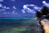
| Tuvalu FeatureType : country Elevation : 8 Lat/Lng : -8.5208 / 179.1986 | Tuvalu (or), formerly known as the Ellice Islands, is a Polynesian island country located in the Pacific Ocean, situated in Oceania, about midway between Hawaii and Australia. It lies east-northeast of the Santa Cruz Islands (belonging to the Solomons), southeast of Nauru, south of Kiribati, west of (...) |
| 7 | 
| Tuamotus FeatureType : isle Lat/Lng : -18.0408 / -141.4094 | The Tuamotus, also referred to in English as the Tuamotu Archipelago or the Tuamotu Islands (, officially), are a French Polynesian chain of almost 80 islands and atolls forming the largest chain of atolls in the world (...) |
| 8 | 
| Pacific Ocean FeatureType : waterbody Lat/Lng : 0.0 / -160.0 | The Pacific Ocean is the largest and deepest of Earth's oceanic divisions. It extends from the Arctic Ocean in the north to the Southern Ocean (or, depending on definition, to Antarctica) in the south and is bounded by Asia and Australia in the west and the Americas in the east (...) |
| 9 | 
| Rotuma FeatureType : null Elevation : 100 Lat/Lng : -12.5 / 177.08 | Rotuma is a Fijian dependency, consisting of Rotuma Island and nearby islets. The island group is home to a large and unique indigenous ethnic group which constitutes a recognisable minority within the population of Fiji, known as "Rotumans" (...) |
| 10 | 
| Funafuti FeatureType : isle Elevation : 8 Lat/Lng : -8.5167 / 179.2 | Funafuti is an atoll on which the capital of the island nation of Tuvalu is located. It has a population of 6,025 people, making it the country's most populated atoll, with 56.6 percent of Tuvalu's population. It is a narrow sweep of land between wide, encircling a large lagoon (Te Namo) long and (...) |
| 11 | 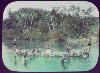
| Solomon Islands FeatureType : country Elevation : 553 Lat/Lng : -9.6667 / 160.2 | Solomon Islands is a country consisting of six major islands and over 900 smaller islands in Oceania lying to the east of Papua New Guinea and northwest of Vanuatu and covering a land area of . The country's capital, Honiara, is located on the island of Guadalcanal (...) |
| 12 | 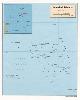
| Marshall Islands FeatureType : country Lat/Lng : 9.1689 / 167.6447 | The Marshall Islands, officially the Republic of the Marshall Islands , are an island country and a United States associated state near the equator in the Pacific Ocean, slightly west of the International Date Line. Geographically, the country is part of the larger island group of Micronesia (...) |
| 13 | 
| Butaritari FeatureType : isle Lat/Lng : 3.1678 / 172.8258 | Butaritari is an atoll in the Pacific Ocean island nation of Kiribati. The atoll is roughly four-sided. The south and southeast portion of the atoll comprises a nearly continuous islet. The atoll reef is continuous but almost without islets along the north side (...) |
| 14 | 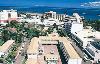
| Suva FeatureType : city Elevation : 57 Lat/Lng : -18.1416 / 178.4419 | Suva is the capital and largest metropolitan city in Fiji. It is located on the southeast coast of the island of Viti Levu, in the Rewa Province, Central Division. In 1877, it was decided to make Suva the capital of Fiji, as the geography of former main European settlement at Levuka on the island of (...) |
| 15 | 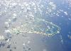
| Tokelau FeatureType : isle Lat/Lng : -8.5517 / -172.501 | Tokelau (; previously known as the Union Islands, and officially as Tokelau Islands until 1976;Tokelau Amendment Act 1976 lit. "north-northeast") is a dependent territory of New Zealand in the southern Pacific Ocean (...) |
| 16 | 
| Honiara FeatureType : city Elevation : 8 Lat/Lng : -9.4382 / 159.9664 | Honiara is the capital city of Solomon Islands, situated on the northwestern coast of Guadalcanal. it had a population of 84,520 people. The city is served by Honiara International Airport and the seaport of Point Cruz, and lies along the Kukum Highway (...) |
| 17 | 
| Orona FeatureType : null Lat/Lng : -4.5 / -172.1667 | Orona atoll, also known as Hull Island,Kiribati Constitution of 12 July 1979 is one of the Phoenix Islands in the Republic of Kiribati. It measures approximately by , and like Kanton, is a narrow ribbon of land surrounding a sizable lagoon with depths of (...) |
| 18 |
| Geography of Kiribati FeatureType : country Lat/Lng : 1.4167 / 173.0 | This article describes the geography of the Republic of Kiribati. Kiribati consists of 32 atolls and one island scattered over all four hemispheres in an expanse of ocean equivalent in size to the continental United States (...) |
| 19 | 
| Papua New Guinea FeatureType : country Lat/Lng : -9.5 / 147.1167 | Papua New Guinea (PNG; , ; ;), officially the Independent State of Papua New Guinea, is an Oceanian country that occupies the eastern half of the island of New Guinea and its offshore islands in Melanesia, a region of the southwestern Pacific Ocean north of Australia (...) |
| 20 | 
| Rawaki Island FeatureType : isle Lat/Lng : -3.7167 / -170.7167 | Rawaki Island is one of the Phoenix Islands in the Republic of Kiribati, also known by its previous name of Phoenix Island. It is a small, uninhabited atoll, approximately in size and in area, with a shallow, brackish lagoon that is not connected to the open sea. It is located at (...) |
| 21 | 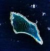
| Kanton Island FeatureType : isle Lat/Lng : -2.8333 / -171.6667 | Kanton Island (also known as Canton Island or Abariringa Island), alternatively known as "Mary Island", "Mary Balcout's Island" or "Swallow Island", is the largest, northernmost, and , the sole inhabited island of the Phoenix Islands, in the Republic of Kiribati (...) |
| 22 | 
| Australia FeatureType : city Elevation : 607 Lat/Lng : -35.3081 / 149.1244 | Australia, officially the Commonwealth of Australia, is a sovereign country comprising the mainland of the Australian continent, the island of Tasmania and numerous smaller islands. It is the largest country in Oceania and the world's sixth-largest country by total area (...) |
| 23 | Gilbert Islands FeatureType : isle Lat/Lng : 3.3333 / 172.9833 | The Gilbert Islands (;Reilly Ridgell. Pacific Nations and Territories: The Islands of Micronesia, Melanesia, and Polynesia. 3rd. Ed. Honolulu: Bess Press, 1995. p. 95. formerly Kingsmill or King's-Mill IslandsVery often, this name applied only to the southern islands of the archipelago, the northern (...) | |
| 24 | 
| Fiji FeatureType : country Elevation : 175 Lat/Lng : -17.8133 / 179.4122 | Fiji (; ; Fiji Hindi: फ़िजी), officially the Republic of FijiIn February 2011, the Prime Minister's Office issued a statement saying that the name of the state had been officially changed from the Republic of the Fiji Islands to the Republic of Fiji, and that the name written in the 1997 (...) |
| 25 | 
| Guadalcanal Campaign FeatureType : adm2nd Elevation : 5 Lat/Lng : -9.428 / 160.0548 | The Guadalcanal Campaign, also known as the Battle of Guadalcanal and codenamed Operation Watchtower by American forces, was a military campaign fought between 7 August 1942 and 9 February 1943 on and around the island of Guadalcanal in the Pacific theater of World War II (...) |
| 26 | 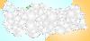
| Devrek FeatureType : null Elevation : 88 Lat/Lng : 41.2253 / 31.9603 | Devrek is a town and district in Zonguldak Province in the Black Sea Region of Turkey. It was founded as Hamidiye, in the sanjak of Bolu. Devrek was incorporated into the Zonguldak Province on May 14, 1920. It is divided into five quarters, three subdistricts and seventy-six villages (...) |
| 27 | 
| Teraina FeatureType : isle Elevation : 4 Lat/Lng : 4.6833 / -160.3778 | Teraina or Teeraina, also known as Washington Island (both names are constitutionalPOK (2007)) is a coral atoll in the central Pacific Ocean and part of the Northern Line Islands which belong to Kiribati. Obsolete names of Teeraina are Prospect Island and New York Island (...) |
| 28 | 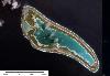
| Nikumaroro FeatureType : isle Lat/Lng : -4.68 / -174.5169 | Nikumaroro, or Gardner Island, is part of the Phoenix Islands, Kiribati, in the western Pacific Ocean. It is a remote, elongated, triangular coral atoll with profuse vegetation and a large central marine lagoon. Nikumaroro is about long by wide (...) |
| 29 | 
| Jarvis Island FeatureType : isle Elevation : 0 Lat/Lng : -0.3667 / -160.0167 | Jarvis Island (; formerly known as Bunker Island, or Bunker's Shoal) is an uninhabited coral island located in the South Pacific Ocean at , about halfway between Hawaii and the Cook Islands. It is an unincorporated, unorganized territory of the United States, administered by the United States Fish (...) |
| 30 | Line Islands FeatureType : null Lat/Lng : 6.4 / -162.4 | The Line Islands, Teraina Islands or Equatorial Islands, is a chain of atolls (with partially or fully enclosed lagoons) and coral islands (with a surrounding reef). Kingman Reef is a largely submerged and Filippo Reef is shown on some maps, although its existence is doubted (...) | |
| 31 | 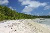
| Palmyra Atoll FeatureType : null Elevation : 11 Lat/Lng : 5.8868 / -162.0796 | Palmyra Atoll is one of the Northern Line Islands (southeast of Kingman Reef and north of Kiribati Line Islands), located almost due south of the Hawaiian Islands, roughly one-third of the way between Hawaii and American Samoa. The nearest continent is almost to the northeast (...) |
| 32 | 
| Enderbury Island FeatureType : isle Elevation : 2 Lat/Lng : -3.1333 / -171.0833 | Enderbury Island (Ederbury Island, Guano Island) is a small, uninhabited atoll 63 km ESE of Kanton Island in the Pacific Ocean at . It is about 1 mile (1.6 km) wide and 3 miles (4.8 km) long, with a reef stretching out 60–200 metres (...) |
| 33 | 
| Diomede Islands FeatureType : isle Lat/Lng : 65.76 / -168.99 | The Diomede Islands (; , ostrová Diomída), also known in Russia as Gvozdev Islands (ostrová Gvozdjeva), consist of two rocky, mesa-like islands: * The Russian island of Big Diomede (part of Chukotka Autonomous Okrug), also known as Imaqliq, Inaliq, Nunarbuk or Ratmanov Island * The U.S (...) |
| 34 | 
| Starbuck Island FeatureType : null Elevation : 7 Lat/Lng : -5.6411 / -155.8789 | Starbuck Island (or Volunteer Island) is an uninhabited coral island in the central Pacific, and is part of the Central Line Islands of Kiribati. Former names include "Barren Island", "Coral Queen Island", "Hero Island", "Low Island", and "Starve Island". (...) |
| 35 | 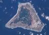
| Malden Island FeatureType : null Elevation : 1 Lat/Lng : -4.015 / -154.9292 | Malden Island, sometimes called Independence Island in the nineteenth century, is a low, arid, uninhabited atoll in the central Pacific Ocean, about in area. It is one of the Line Islands belonging to the Republic of Kiribati (...) |
| 36 | 
| Manra Island FeatureType : null Elevation : 0 Lat/Lng : -4.4542 / -171.2458 | Manra Island or Sydney Island, is one of the Phoenix Islands in the Republic of Kiribati. It lies at . longitude, and has an area of 4.4 km2. and an elevation of approximately six meters. Together with the seven other Phoenix Islands, it forms part of the Phoenix Islands Protected Area, (...) |
| 37 | 
| Sea Launch FeatureType : null Lat/Lng : 0.0 / -154.0 | Sea Launch is a multinational spacecraft launch service that used a mobile maritime launch platform for equatorial launches of commercial payloads on specialized Zenit-3SL rockets through 2014. By 2014, it had assembled and launched thirty-two rockets, with an additional three failures and one (...) |
| 38 | South Tarawa FeatureType : city Lat/Lng : 1.4 / 172.9667 | South Tarawa (in Gilbertese Tarawa Teinainano) is the capital and hub of the Republic of Kiribati and home to approximately half of Kiribati's population. The South Tarawa population centre consists of all the small islets from Betio in the west to Bonriki and Tanaea in the east, connected by the (...) | |
| 39 | Abaiang FeatureType : isle Lat/Lng : 1.839 / 172.9499 | Abaiang, also known as Apaiang, Apia, and in the past, Charlotte Island, in the Northern Gilbert Islands, is a coral atoll of Kiribati, located in the west-central Pacific Ocean. Abaiang was the home of the first missionary to arrive in Kiribati, Hiram Bingham II (...) | |
| 40 | International Date Line FeatureType : null Lat/Lng : 0.0 / -180.0 | The International Date Line (IDL) is an imaginary line of demarcation on the surface of Earth that runs from the North Pole to the South Pole and demarcates the change of one calendar day to the next. It passes through the middle of the Pacific Ocean, roughly following the 180° line of longitude but (...) | |
| 41 | Bonriki International Airport FeatureType : airport Elevation : 7 Lat/Lng : 1.3816 / 173.1443 | Bonriki International Airport is an international airport in Kiribati, serving as the main gateway to the country. It is located in its capital, South Tarawa, which is a group of islets in the atoll of Tarawa in the Gilbert Islands (...) | |
| 42 | Nonouti FeatureType : null Lat/Lng : -0.677 / 174.3844 | Nonouti is an atoll and district of Kiribati. The atoll is located in the South Gilbert Islands, 38 km north of Tabiteuea, and 250 km south of Tarawa. The atoll is the third largest in the Gilbert Islands and is the island where the Catholic religion was first established in Kiribati, in 1888. (...) | |
| 43 | Tamana, Kiribati FeatureType : null Lat/Lng : -2.5 / 175.9667 | Tamana is the smallest island in the Gilbert Islands. It is accessible both by boat and by air with Air Kiribati and Coral Sun Airways (once a week; airport code: TMN) Tamana is the second southern-most island in the Gilbert group and the smallest inhabited island in Kiribati (...) | |
| 44 | 
| Swains Island FeatureType : isle Elevation : 0 Lat/Lng : -11.0531 / -171.0825 | Swains Island (; Samoan: Olosega; Tokelauan: Olohega) is an atoll in the Tokelau chain. The island is subject to an ongoing territorial dispute between Tokelau, of which the island is culturally part, and the United States of America, which administers it as part of American Samoa (...) |
| 45 | Aiaki FeatureType : null Elevation : 8 Lat/Lng : -1.8942 / 175.6151 | Aiaki is a settlement in Kiribati. It is located on Onotoa atoll about from Tarawa. | |
| 46 | Outline of Kiribati FeatureType : null Lat/Lng : 1.8737 / -157.4258 | The following outline is provided as an overview of and topical guide to Kiribati: Kiribati – sovereign island nation located in the central equatorial Pacific Ocean. (...) | |
| 47 | Bonriki FeatureType : isle Elevation : 9 Lat/Lng : 1.3658 / 173.1562 | Bonriki is a settlement on Tarawa atoll, Kiribati, and part of the municipality of South Tarawa. Bonriki International Airport, one of two international airports in Kiribati is located here. (...) | |
| 48 | Caroline Island FeatureType : isle Lat/Lng : -9.9369 / -150.2111 | Caroline Island or Caroline Atoll (also known as Millennium Island and Beccisa Island), is the easternmost of the uninhabited coral atolls which comprise the southern Line Islands in the central Pacific Ocean. First sighted by Europeans in 1606, claimed by the United Kingdom in 1868, and part of the (...) | |
| 49 | Abemama FeatureType : null Lat/Lng : 0.3996 / 173.8768 | Abemama (Apamama) is an atoll, one of the Gilberts group in Kiribati, and is located southeast of Tarawa and just north of the Equator. Abemama has an area of and a population of 3,213 . The islets surround a deep lagoon (...) | |
| 50 | 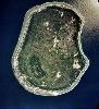
| Geography of Nauru FeatureType : country Elevation : 22 Lat/Lng : -0.5352 / 166.932 | Nauru is a tiny phosphate rock island nation located in the South Pacific Ocean south of the Marshall Islands in Oceania. It is only south of the Equator at coordinates . Nauru is one of the three great phosphate rock islands in the Pacific Ocean — the others are Banaba (Ocean Island) in (...) |
| 51 | Gilbert and Ellice Islands FeatureType : null Lat/Lng : 1.26 / 173.02 | The Gilbert and Ellice Islands were a British protectorate from 1892 and colony from 1916 until 1 January 1976, when the islands were divided into two colonies which became independent nations shortly after. A referendum was held in December 1974 to determine whether the Gilbert Islands and Ellice (...) | |
| 52 | Nikunau FeatureType : null Lat/Lng : -1.35 / 176.4667 | Nikunau is a low coral atoll in the Gilbert Islands and forms a council district of the Republic of Kiribati. It consists of two parts, (the larger one in the northwest), joined by an isthmus about wide. There are several landlocked, hypersaline lagoons located within the island, measuring about in (...) | |
| 53 | Beru Island FeatureType : null Lat/Lng : -1.3167 / 175.9667 | Beru Island is an island in the Kingsmill Group of the South Gilbert Islands in the Pacific Ocean, part of the Republic of Kiribati. Beru was previously known as Eliza, Francis Island, Maria, Peroat, Peru Island or Sunday. (...) | |
| 54 | Umantewena FeatureType : city Elevation : 12 Lat/Lng : -0.7384 / 174.4542 | Umantewena is a settlement on the Nonouti atoll in Kiribati. Tenanoraoi is to its south, while Makauro, Tetake, and Umauma are to its north. (...) | |
| 55 | Tabiauea FeatureType : city Elevation : 0 Lat/Lng : 0.9275 / 173.0277 | Tabiauea is a settlement in Kiribati. It is located on Maiana Atoll; the nearest location, about six nautical miles north, is Tebikerei. | |
| 56 | Tabiteuea FeatureType : null Lat/Lng : -1.35 / 174.8 | Tabiteuea, formerly Drummond's Island, is an atoll in the Gilbert Islands, Kiribati, farther south of the Tarawa Atoll. The atoll consists of two main islands: Eanikai in the north, Nuguti in the south, and several smaller islets in between along the eastern rim of the atoll (...) | |
| 57 | Tabuaeran FeatureType : null Elevation : 4 Lat/Lng : 3.86 / -159.3644 | Tabuaeran or Tahanea, known in English as Fanning Atoll (both Gilbertese and English names are recognised), is an atoll that is part of the Line Islands of the central Pacific Ocean and part of Kiribati. The land area is , and the population in 2010 was 1,960 (...) | |
| 58 | Ratak Chain FeatureType : isle Lat/Lng : 9.0 / 171.0 | The Ratak Chain (Marshallese:) is a chain of islands within the island nation of the Marshall Islands. Ratak means "sunrise". It lies to the east of the country's other island chain, the Ralik Chain. In 1999 the total population of the Ratak islands was 30,925 (...) | |
| 59 | Makin (islands) FeatureType : isle Elevation : 4 Lat/Lng : 3.3833 / 173.0 | Makin is the name of a chain of islands located in the Pacific Ocean island nation of Kiribati. Makin is the northernmost of the Gilbert Islands, with a population (in 2010) of 1,798. (...) | |
| 60 | Extreme points of Earth FeatureType : null Lat/Lng : -80.0 / -115.0 | This is a list of extreme points of Earth, the geographical locations that are farther north or south than, higher or lower in elevation than, or farthest inland or out to sea from, any other locations on the landmasses, continents or countries (...) | |
| 61 | Kuria (islands) FeatureType : isle Lat/Lng : 0.2286 / 173.4106 | Kuria is the name of a pair of islets in the Central Gilbert Islands in Kiribati, northwest of Aranuka. The two islets, Buariki and Oneeke, are separated by a 20 metre wide channel on a shallow water platform (Te breeti), which is crossed by a bridge of the connecting road (...) | |
| 62 | Maiana FeatureType : null Lat/Lng : 0.9391 / 173.0002 | Maiana is an atoll in Kiribati and is one of the Central Gilbert Islands. Maiana is south of the capital island of South Tarawa and has a population of 2,027 . The northern and eastern sides of the atoll are a single island, whilst the western edge consists of submerged reefs and many uninhabited (...) | |
| 63 | Biketawa FeatureType : isle Elevation : 9 Lat/Lng : 1.436 / 173.0727 | Biketawa is one of the twenty-four small islets which comprise the atoll of Tarawa in the Republic of Kiribati. The capital of Kiribati, South Tarawa, is located on Tarawa. The 2000 Biketawa Declaration on Pacific regional security takes its name from Biketawa. (...) | |
| 64 | Aranuka Airport FeatureType : null Elevation : 11 Lat/Lng : 0.1853 / 173.6364 | Aranuka Airport is an airport, located approximately one kilometre north of the centre of Buariki village on the island of Buariki, Aranuka, Kiribati. The airport is served twice a week by Air Kiribati from Kuria Airport on Kuria (...) | |
| 65 | 235 Carolina FeatureType : null Lat/Lng : 4.0 / 0.0 | Carolina (minor planet designation: 235 Carolina) is a sizeable Main belt asteroid. It is an S-type asteroid. It was discovered by Johann Palisa on 28 November 1883 in Vienna. The asteroid was named after Caroline Island, now part of Kiribati. (...) | |
| 66 | London, Kiribati FeatureType : city Elevation : 8 Lat/Lng : 1.9833 / -157.475 | London (also Ronton in Gilbertese) is the principal settlement on the atoll of Kiritimati (also known as Christmas Island) belonging to Kiribati in the Pacific Ocean. As of 2005 it has a population of 1,829 people, making it the second largest village on Kiritimati and in the whole Line Islands (...) | |
| 67 | Utiroa FeatureType : city Elevation : 11 Lat/Lng : -1.2142 / 174.7587 | Utiroa is a settlement in Kiribati. It is located on Tabiteuea atoll; Nuribenua is to its west, while Terikiai and Eita are to its north. (...) | |
| 68 | Bairiki FeatureType : city Elevation : 9 Lat/Lng : 1.3289 / 172.9756 | Bairiki is one of the largest towns in South Tarawa of Kiribati. The State House, the National Stadium, the High Commissions of Australia and New Zealand as well as the embassy of Taiwan, and most of the Government Ministries are based in Bairiki (...) | |
| 69 | Eita, Kiribati FeatureType : null Elevation : 11 Lat/Lng : 1.3615 / 173.0811 | Eita is a settlement in Kiribati. It is located on an atoll in South Tarawa. There is another settlement in Tab. with Utiroa is to its east and Terikiai to its north; Nuribenua, Tanaiang, and Te Kapuipui are to the west. (...) | |
| 70 | Santa Rosa de Osos FeatureType : city Elevation : 2586 Lat/Lng : 6.6474 / -75.4603 | Santa Rosa de Osos is a middle city and municipality of Colombia located in the northern of the department of Antioquia. Bounded on the north with the municipalities of Yarumal and Angostura, on the east with Guadalupe and Carolina del Principe, on the south with the municipalities of Donmatías, San (...) | |
| 71 | Honolulu County, Hawaii FeatureType : adm2nd Elevation : 218 Lat/Lng : 21.4667 / -157.9667 | Honolulu County (officially known as the City and County of Honolulu, formerly Oahu County) is a consolidated city–county in the U.S. state of Hawaii. The city–county includes both the city of Honolulu (the state's capital and largest city) and the rest of the island of Oahu, as well as several (...) | |
| 72 | FIFA FeatureType : landmark Elevation : 600 Lat/Lng : 47.3813 / 8.5744 | The Fédération Internationale de Football Association (FIFA ; French for "International Federation of Association Football") is an organization which describes itself as an international governing body of association football, futsal, and beach soccer (...) | |
| 73 | Phoenix Islands FeatureType : isle Lat/Lng : -2.8333 / -171.6667 | The Phoenix Islands or Rawaki are a group of eight atolls and two submerged coral reefs, lying in the central Pacific Ocean east of the Gilbert Islands and west of the Line Islands. They are a part of the Republic of Kiribati (...) | |
| 74 | Arorae FeatureType : isle Elevation : 12 Lat/Lng : -2.6436 / 176.8317 | Arorae (previously known as Arorai, Arurai, Hope Island or Hurd) is an atoll in Kiribati located near the equator. Arorae is the southernmost island in the Gilbert Islands group. It houses almost 1300 people on 9.5 square kilometres. (...) | |
| 75 | University of East Anglia FeatureType : edu Elevation : 27 Lat/Lng : 52.6217 / 1.2417 | The University of East Anglia (UEA) is a public research university in Norwich, England. Established in 1963 on a campus west of the city centre, the university has four faculties and 26 schools of study. The annual income of the institution for 2016–17 was £273.7 million of which £35 (...) | |
| 76 | UNESCO FeatureType : landmark Elevation : 35 Lat/Lng : 48.8501 / 2.3062 | The United Nations Educational, Scientific and Cultural Organization (UNESCO;) is a specialized agency of the United Nations (UN) based in Paris. Its declared purpose is to contribute to peace and security by promoting international collaboration through educational, scientific, and cultural reforms (...) | |
| 77 | 2010 Chile earthquake FeatureType : event Lat/Lng : -35.846 / -72.719 | The 2010 Chile earthquake occurred off the coast of central Chile on Saturday, 27 February at 03:34 local time (06:34 UTC), having a magnitude of 8.8 on the moment magnitude scale, with intense shaking lasting for about three minutes (...) | |
| 78 | Commonwealth Games FeatureType : null Elevation : 22 Lat/Lng : 51.5072 / -0.1275 | The Commonwealth Games are an international multi-sport event involving athletes from the Commonwealth of Nations. The event was first held in 1930, and has taken place every four years since then. The Commonwealth Games were known as the British Empire Games from 1930 to 1950, the British Empire (...) | |
| 79 | Polynesia FeatureType : null Lat/Lng : -16.853 / 148.4052 | Polynesia (; from polys "many" and nēsos "island"; , , or Poronihia) is a subregion of Oceania, made up of more than 1,000 islands scattered over the central and southern Pacific Ocean. The indigenous people who inhabit the islands of Polynesia are termed Polynesians, and share many similar traits (...) | |
| 80 | 2016 FeatureType : null Elevation : 25 Lat/Lng : 30.6004 / 114.6192 | 2016 was designated as: * International Year of Pulses by the sixty-eighth session of the United Nations General Assembly. * International Year of Global Understanding (IYGU) by the International Council for Science (ICSU), the International Social Science Council (ISSC), and the International (...) | |
| 81 | Western Hemisphere FeatureType : null Lat/Lng : 0.0 / -90.0 | The Western Hemisphere is a geographical term- for the half of Earth which lies west of the prime meridian (which crosses Greenwich, London, United Kingdom) and east of the antimeridian. The other half is called the Eastern Hemisphere. (...) | |
| 82 | 180th meridian FeatureType : waterbody Lat/Lng : 90.0 / 180.0 | The 180th meridian or antimeridianThe word antimeridian can also mean the meridian opposite to any given meridian. E.g. 20° west is the antimeridian of 160° east. is the meridian 180° both east and west of the Prime Meridian, with which it forms a great circle dividing the earth into the Western and (...) | |
| 83 | Marakei FeatureType : null Elevation : 0 Lat/Lng : 2.0137 / 173.2767 | Marakei is a small atoll in the North Gilbert Islands. The central lagoon consists of numerous deep basins and surrounded by two large islands which are separated by two narrow channels. The atoll covers an area of approximately 40 km². (...) | |
| 84 | Betio FeatureType : isle Elevation : 13 Lat/Lng : 1.3563 / 172.9316 | Betio is the largest township of Kiribati's capital city, South Tarawa, and the country's main port. The settlement is located on a separate islet at the extreme southwest of the atoll. Betio Post Office opened on 5 April 1957 and closed in 1964 (...) | |
| 85 | Buariki (Aranuka) FeatureType : null Elevation : 13 Lat/Lng : 0.1461 / 173.6341 | Buariki is the largest island in the Aranuka atoll of the Gilbert Islands in the Republic of Kiribati. Together with Takaeang the two large islands form the triangle shape of the atoll with Buariki forming the base. (...) | |
| 86 | Atoll FeatureType : null Lat/Lng : -5.27 / 159.35 | An atoll (or),pronunciation in old video on youtube, sometimes called a coral atoll, is a ring-shaped coral reef including a coral rim that encircles a lagoon partially or completely. There may be coral islands or cays on the rim (...) | |
| 87 | Aranuka FeatureType : null Lat/Lng : 0.1667 / 173.5833 | Aranuka is an atoll of Kiribati, located just north of the equator, in the Gilbert Islands. It has an area of and a population of 1,057 in 2010. By local tradition, Aranuka is the central island of the Gilbert group. (...) | |
| 88 | Amelia Earhart FeatureType : isle Elevation : 8 Lat/Lng : 0.8067 / -176.6164 | Amelia Mary Earhart (born July 24, 1897; disappeared July 2, 1937) was an American aviation pioneer and author. Earhart was the first female aviator to fly solo across the Atlantic Ocean. She received the United States Distinguished Flying Cross for this accomplishment (...) | |
| 89 | Nikumanu FeatureType : city Elevation : 11 Lat/Lng : -1.3837 / 176.4743 | Nikumanu is a settlement on Nikunau Island in Kiribati. The nearest locations are Rungata and Manriki, to the north; and Tabomatang, to the south. All are between one and four miles away. | |
| 90 | Abaokoro FeatureType : city Elevation : 13 Lat/Lng : 1.4906 / 173.0256 | Abaokoro is a settlement in Kiribati. It is located about nine nautical miles from Tarawa. It is located in the Tarawa Atoll. Abaokoro Post Office opened on 13 December 1956. (...) | |
| 91 | Cassidy International Airport FeatureType : airport Elevation : 6 Lat/Lng : 1.9862 / -157.3498 | Cassidy International Airport is an airport located north of Banana, a settlement on Kiritimati (also known as Christmas Island) in Kiribati. It is the only airport in the Kiribati part of the Line Islands with an IATA and/or ICAO code (...) | |
| 92 | Beru Island Airport FeatureType : null Elevation : 5 Lat/Lng : -1.3554 / 176.0087 | Beru Island Airport is the airport serving Beru Island. The island is located in the Kingsmill Group of the South Gilbert Islands in the Pacific Ocean and is part of the Republic of Kiribati. The airport is located in the south of the island and is served by Air Kiribati and Coral Sun Airways, each (...) | |
| 93 | Nikunau Airport FeatureType : null Elevation : 8 Lat/Lng : -1.3151 / 176.4093 | Nikunau Airport is the airport serving Nikunau, Kiribati. It is located on the western tip of the atoll. The airport is served by Air Kiribati from Beru Island Airport on Beru Island, from which flights to Bonriki International Airport in Tarawa are available. (...) | |
| 94 | Abaiang Atoll Airport FeatureType : airport Elevation : 9 Lat/Lng : 1.7991 / 173.0402 | Abaiang Atoll Airport , often abbreviated Abaiang Airport, is the airport serving Abaiang, Kiribati. It is located on Abaiang Island, between the villages of Tabwiroa (north) and Tuarabu (south). The airport is served by Air Kiribati from South Tarawa and Marakei on Wednesdays, Fridays and Sundays (...) | |
| 95 | Nui (atoll) FeatureType : isle Lat/Lng : -7.2247 / 177.1603 | Nui is an atoll and one of nine districts of the Pacific Ocean state of Tuvalu. It has a land area of 3.37 km² and a population of 542 (2012 census). Traditionally Nuian culture is organised in three family circles - Tekaubaonga, Tekaunimala and Tekaunibiti families (...) | |
| 96 | House of Assembly (Kiribati) FeatureType : landmark Elevation : 6 Lat/Lng : 1.3503 / 173.0389 | The House of Assembly (official constitutional name: Maneaba ni Maungatabu or "supreme maneaba") of Kiribati has 46 members, 44 elected for a four-year term in single-seat and multi-seat constituencies, 1 delegate from Banaba Island and 1 ex officio member (the Attorney General) (...) | |
| 97 | Vostok Island FeatureType : null Lat/Lng : -10.0633 / -152.3111 | Vostok Island, also known as Staver Island, is an uninhabited coral island in the central Pacific Ocean, part of the Line Islands belonging to Kiribati. Other names for the island include Anne Island, Bostock Island, Leavitts Island, Reaper Island, Wostock Island or Wostok Island (...) | |
| 98 | Flint Island FeatureType : null Elevation : 23 Lat/Lng : -11.43 / -151.8194 | Flint Island is an uninhabited coral island in the central Pacific Ocean, part of the Southern Line Islands under the jurisdiction of Kiribati. In 2014 the Kiribati government established a exclusion zone around each of the southern Line Islands (Caroline (commonly called Millennium), Flint, Vostok, (...) | |
| 99 | Onotoa FeatureType : null Lat/Lng : -1.8574 / 175.5545 | Onotoa is an atoll and district of Kiribati. It is situated in the Gilbert Islands in the Pacific Ocean, from Tamana, the smallest island in the Gilberts. The population of Onotoa in the 2010 census was 1,519. The atoll is similar to many other atolls in the Gilbert Islands with its continuous line (...) | |
| 100 | Birnie Island FeatureType : null Lat/Lng : -3.5833 / -171.55 | Birnie Island is a small, uninhabited coral island, 20 hectares in area, part of the Phoenix Island group, that is part of the Republic of Kiribati. It is located about 100 km SE of Kanton Island and 90 km WNW of Rawaki Island, formerly known as Phoenix Island. It lies at (...) | |
| 101 | Vaitupu FeatureType : isle Lat/Lng : -7.4667 / 178.6833 | Vaitupu is the largest atoll of the nation of Tuvalu. It is located at 7.48 degrees south and 178.83 degrees west. There are 1,555 people (2012 census) living on with the main village being Asau. (...) | |
| 102 | Nanumea FeatureType : isle Lat/Lng : -5.6639 / 176.1095 | Nanumea is the northwesternmost atoll in the Polynesian nation of Tuvalu, a group of nine coral atolls and islands spread over about of Pacific Ocean just south of the equator and west of the International Date Line. Nanumea is with a population of 544 people (2012 census). (...) | |
| 103 | McKean Island FeatureType : isle Elevation : 5 Lat/Lng : -3.595 / -174.1225 | McKean Island is a small, uninhabited island in the Phoenix Islands, Republic of Kiribati. It is located at . Its area is . Kiribati declared the Phoenix Islands Protected Area in 2006, with the park being expanded in 2008 (...) | |
| 104 | Nukufetau FeatureType : isle Lat/Lng : -7.9918 / 178.3744 | Nukufetau is an atoll that is part of the nation of Tuvalu. The atoll was claimed by the US under the Guano Islands Act some time in the 19th century and was ceded in a treaty of friendship concluded in 1979 and coming into force in 1983 (...) | |
| 105 | Bhuj FeatureType : null Elevation : 105 Lat/Lng : 23.2461 / 69.6664 | Bhuj is a Municipality and District Headquarter of Kutch District in the state of Gujarat, India. (...) | |
| 106 | Vanua Levu FeatureType : isle Elevation : 278 Lat/Lng : -16.5833 / 179.1833 | Vanua Levu (pronounced), formerly known as Sandalwood Island, is the second largest island of Fiji. Located to the north of the larger Viti Levu, the island has an area of and a population of 135,961 . (...) | |
| 107 | Arorae Island Airport FeatureType : airport Elevation : 7 Lat/Lng : -2.6159 / 176.8003 | Arorae Island Airport is the airport serving Arorae, Kiribati. It is located in the north of the island, north of the village of Tamaroa. The airport is served by Air Kiribati from Tabiteuea North, which is connected directly with the international airport at South Tarawa, but lands at Tamana too on (...) | |
| 108 | Takaeang FeatureType : null Elevation : 11 Lat/Lng : 0.181 / 173.5529 | Takaeang is the second largest island in the Aranuka atoll of Kiribati. It helps form the triangular shape of the atoll by forming the top corner of the triangle. It is connected to the larger island, Buariki, by a sandbank. The village is also called Takaeang. (...) | |
| 109 | Tabwakea FeatureType : city Elevation : 7 Lat/Lng : 2.0181 / -157.4877 | Tabwakea is a settlement in Kiribati. It is located on the island of Kiritimati. In 2005 it had a population of 1,881 people. In 2010 it had a population of 2,311. It is the largest village on Kiritimati and in the whole Line Islands. (...) | |
| 110 | Niutao FeatureType : isle Elevation : 14 Lat/Lng : -6.1086 / 177.3425 | Niutao is a reef island in the northern part of Tuvalu. It is one of the nine districts (islands) of Tuvalu. It is also one of the three districts that consist of only one island - not counting the three islets inside the closed lagoon. Niutao has a population of 606 (2012 census). (...) | |
| 111 | Leeward Islands (Society Islands) FeatureType : isle Elevation : 109 Lat/Lng : -17.5333 / -149.8333 | The Leeward Islands (; , literally "Islands Under-the-Wind") are the western part of the Society Islands in French Polynesia, an overseas collectivity of France in the South Pacific. They lie south of the Line Islands (part of Kiribati), east of the Cooks and north of the Austral Islands (also part (...) | |
| 112 | Nukulaelae FeatureType : isle Elevation : 1 Lat/Lng : -9.3811 / 179.8522 | Nukulaelae is an atoll that is part of the nation of Tuvalu, and has a population of 324 (2012 census) the largest settlement is Pepesala on Fangaua islet with a population of 247 people (2012 census). It has the form of an oval and consists of at least 15 islets (...) | |
| 113 | Roreti FeatureType : null Elevation : 11 Lat/Lng : -2.6551 / 176.833 | Roreti is a village in Arorae, Kiribati. The name is a local transliteration of Royalist. There are only two villages on the island, Tamaroa the northern village (population 426, 2010 census) and Roreti (population 853, 2010 census) is the southern village (...) | |
| 114 | Phoenix Islands Protected Area FeatureType : landmark Lat/Lng : -3.6497 / -172.8575 | The Phoenix Islands Protected Area (PIPA) is located in the Republic of Kiribati, an ocean nation in the central Pacific approximately midway between Australia and Hawaii. PIPA constitutes 11.34% of Kiribati’s Exclusive Economic Zone (EEZ) and with a size of it is one of the largest marine protected (...) | |
| 115 | Geography of Tuvalu FeatureType : null Lat/Lng : -5.6833 / 176.2 | The Western Pacific nation of Tuvalu, formerly known as the Ellice Islands, is situated and is 26 km big northeast of Australia and is approximately halfway between Hawaii and Australia. It lies east-northeast of the Santa Cruz Islands (belonging to the Solomons), southeast of Nauru, south of (...) | |
| 116 | 2009 Samoa earthquake and tsunami FeatureType : landmark Lat/Lng : -15.509 / -172.034 | The 2009 Samoa earthquake and tsunami took place on 29 September 2009 in the southern Pacific Ocean adjacent to the Kermadec-Tonga subduction zone. The submarine earthquake occurred in an extensional environment and had a moment magnitude of 8.1 and a maximum Mercalli intensity of VI (Strong) (...) | |
| 117 | Coordinated Universal Time FeatureType : null Elevation : 65 Lat/Lng : 48.8293 / 2.2202 | Coordinated Universal Time (abbreviated to UTC) is the primary time standard by which the world regulates clocks and time. It is within about 1 second of mean solar time at 0° longitude, and is not adjusted for daylight saving time (...) | |
| 118 | University of the South Pacific FeatureType : null Elevation : 4 Lat/Lng : -18.1491 / 178.4478 | The University of the South Pacific (USP) is an intergovernmental organisation and public research university with locations spread throughout a dozen countries in Oceania. It is an international centre for teaching and research on Pacific culture and environment (...) | |
| 119 | Temaraia FeatureType : city Elevation : 7 Lat/Lng : -0.6706 / 174.4495 | Temaraia is a settlement in Kiribati. It is located on an atoll; to its north are Rotuma and Autukia, while Makauro, Tetake, Umauma, Tebatabuki, and Umantewena all lie to its south. | |
| 120 | Marakei Airport FeatureType : null Elevation : 7 Lat/Lng : 2.0587 / 173.2717 | Marakei Airport is the airport serving Marakei, Kiribati. It is located on the northern tip of the atoll, near the village of Rawannawi. The airport is served by Air Kiribati from Abaiang (which has a direct connection with the international airport at South Tarawa) on Wednesdays, Fridays and (...) | |
| 121 | Kashipur, Uttarakhand FeatureType : null Elevation : 239 Lat/Lng : 29.2136 / 78.9558 | Kashipur is a city of Udham Singh Nagar district in the Indian state of Uttarakhand, and one of its seven subdivisions. Located in the western part of Udham Singh Nagar district, it is Kumaun's third most populous city and the sixth most populous in Uttarakhand (...) | |
| 122 | Antipodes FeatureType : null Lat/Lng : -21.4167 / -140.1833 | In geography, the antipode of any spot on Earth is the point on Earth's surface diametrically opposite to it; the antipodes of a region similarly represent the area opposite it. A pair of points antipodal to each other are situated such that a straight line connecting the two would pass through (...) | |
| 123 | University of Canterbury FeatureType : edu Elevation : 24 Lat/Lng : -43.5233 / 172.5819 | The University of Canterbury (; postnominal abbreviation Cantuar. or Cant. for Cantuariensis, the Latin name for Canterbury) is New Zealand's second oldest university. It was founded in 1873 as Canterbury College, the first constituent college of the University of New Zealand (...) | |
| 124 | Bikenibeu FeatureType : city Elevation : 13 Lat/Lng : 1.367 / 173.126 | Bikenibeu is a settlement in Kiribati. It is located close to the southeastern corner of the Tarawa atoll, part of the island country of Kiribati. It is part of a nearly continuous chain of settlements along the islands of South Tarawa, which are now linked by causeways (...) | |
| 125 | Pacific Islands Forum FeatureType : landmark Elevation : 45 Lat/Lng : -18.1503 / 178.439 | The Pacific Islands Forum (PIF) is an inter-governmental organization that aims to enhance cooperation between countries and territories of the Pacific Ocean. It was founded in 1971 as the South Pacific Forum. In 1999, the name was changed; "Pacific Islands Forum" is more inclusive of the Forum's (...) | |
| 126 | Poland, Kiribati FeatureType : city Elevation : 7 Lat/Lng : 1.8648 / -157.5515 | Poland is one of four villages on the island of Kiritimati (Christmas Island), Kiribati. The village was named after a Polish explorer and engineer Stanisław Pełczyński who aided the villagers. He solved the problem with watering palm trees in dry season by suggesting a modified irrigating system (...) | |
| 127 | The Cove (film) FeatureType : city Lat/Lng : 33.5988 / 135.9464 | The Cove is a 2009 documentary film directed by Louie Psihoyos which analyzes and questions dolphin hunting practices in Japan. It was awarded the Academy Award for Best Documentary Feature in 2010. The film is a call to action to halt mass dolphin kills, change Japanese fishing practices, and to (...) | |
| 128 | Roman Catholic Archdiocese of New York FeatureType : landmark Elevation : 35 Lat/Lng : 40.7575 / -73.9636 | The Roman Catholic Archdiocese of New York is a Latin Catholic archdiocese in New York State. It encompasses the boroughs of Manhattan, the Bronx and Staten Island in New York City and the Counties of Dutchess, Orange, Putnam, Rockland, Sullivan, Ulster, and Westchester in New York (...) | |
| 129 | Judicial Committee of the Privy Council FeatureType : null Elevation : 14 Lat/Lng : 51.5004 / -0.1281 | The Judicial Committee of the Privy Council (JCPC) is the highest court of appeal for certain British territories and Commonwealth countries. Established on 13 August 1833 to hear appeals formerly heard by the King-in-Council, the Privy Council formerly acted as the court of last resort for the (...) | |
| 130 | Rungata FeatureType : city Elevation : 9 Lat/Lng : -1.3424 / 176.4357 | Rungata, or Rungataa, is a settlement on Nikunau Island in Kiribati. It is the largest settlement on the island, with a population of almost 1,000, including residents of the adjacent Nikunau Island Council compound (or government station) and of the Nikunau Island Junior Secondary School (...) | |
| 131 | Takarano FeatureType : city Elevation : 16 Lat/Lng : 1.9499 / 172.9123 | Takarano is a the most northern village on Abaiang, atoll in Kiribati. Ubanteman is the village to its south. There are 348 residents of Takarano (2010 census). The village has a medical clinic that is staffed by a Nursing Officer and the clinic is accessed by resident of the Takarano and Ubwanteman (...) | |
| 132 | Autukia FeatureType : city Lat/Lng : -0.6496 / -174.4385 | Autukia is a settlement in Kiribati it had a population of 112 in the 2010 census. It is located on Nonouti atoll; to its north are Abamakoro, Benuaroa, Teuabu, Temanoku and Rotuma, while Matang(the administrative centre), Taboiaki (the largest village) and Temotu are to the south. (...) | |
| 133 | Taboiaki FeatureType : null Lat/Lng : -1.3167 / 175.9667 | Taboiaki is a settlement in Kiribati. It is located on the atoll of Nonouti; It is the largest village with 662 residents in the 2010 census (26% of the population of Nonouti). Matang is the administrative centre with 536 residents (20% of the island's population in 2010). (...) | |
| 134 | Washington FeatureType : null Lat/Lng : -60.7 / -44.916 | Washington most commonly refers to: * George Washington (1732–1799), the first President of the United States * Washington (state), United States * Washington, D.C., the capital of the United States * The Washington metropolitan area, the metropolitan area centered on Washington, D.C (...) | |
| 135 | Namdrik Atoll FeatureType : adm2nd Lat/Lng : 5.6167 / 168.1167 | Namdrik Atoll or Namorik Atoll (Marshallese:) is a coral atoll of two islands in the Pacific Ocean, and forms a legislative district of the Ralik Chain of the Marshall Islands. Its total land area is only , but it encloses a lagoon with an area of (...) | |
| 136 | Nanumanga FeatureType : isle Elevation : 9 Lat/Lng : -6.2873 / 176.3176 | Nanumanga or Nanumaga is a reef island and a district of the Oceanian island nation of Tuvalu. It has a surface area of about 3 km² with a population of 481 (2012 census). (...) | |
| 137 | Battle of Tarawa FeatureType : event Lat/Lng : 1.4269 / 172.9756 | The Battle of Tarawa was a battle in the Pacific Theater of World War II that was fought on 20–23 November 1943. It took place at the Tarawa Atoll in the Gilbert Islands, and was part of Operation Galvanic, the U.S. invasion of the Gilberts (...) | |
| 138 | Food and Agriculture Organization FeatureType : landmark Elevation : 37 Lat/Lng : 41.8823 / 12.4883 | The Food and Agriculture Organization of the United Nations (FAO;) is a specialized agency of the United Nations that leads international efforts to defeat hunger. Serving both developed and developing countries, FAO acts as a neutral forum where all nations meet as equals to negotiate arguments and (...) | |
| 139 | Solar eclipse of May 10, 2013 FeatureType : null Lat/Lng : 2.2206 / 175.4706 | An annular solar eclipse took place on May 9–10 (UTC), 2013, with a magnitude of 0.9544. A solar eclipse occurs when the Moon passes between Earth and the Sun, thereby totally or partly obscuring the image of the Sun for a viewer on Earth (...) | |
| 140 | Special member state territories and the European Union FeatureType : null Elevation : 54 Lat/Lng : 57.9058 / 27.7132 | The special territories of the European Union are 31 territories of EU member states which, for historical, geographical, or political reasons, enjoy special status within or outside the European Union. The special territories divided themselves in two categories: 9 Outermost Regions (OMR) that form (...) | |
| 141 | Edward O'Hare FeatureType : null Lat/Lng : 1.4333 / -171.9333 | Lieutenant Commander Edward Henry "Butch" O'Hare (March 13, 1914 – November 26, 1943) was an American naval aviator of the United States Navy, who on February 20, 1942, became the Navy's first flying ace when he single-handedly attacked a formation of nine heavy bombers approaching his aircraft (...) | |
| 142 | AFL Grand Final FeatureType : event Elevation : 10 Lat/Lng : -37.82 / 144.9833 | The AFL Grand Final is an annual Australian rules football match, traditionally held on the final Saturday in September or the first Saturday in October at the Melbourne Cricket Ground in Melbourne, Australia, to determine the Australian Football League (AFL) premiers for that year (...) | |
| 143 | Chinese space program FeatureType : null Elevation : 1078 Lat/Lng : 40.957 / 100.2922 | The space program of the People's Republic of China is directed by the China National Space Administration (CNSA). Its technological roots can be traced back to the late 1950s, when China began a ballistic missile program in response to perceived American (and, later, Soviet) threats (...) | |
| 144 | Butaritari Atoll Airport FeatureType : airport Elevation : 8 Lat/Lng : 3.0853 / 172.8086 | Butaritari Atoll Airport is an airport on Butaritari in the Pacific Ocean island nation of Kiribati. (...) | |
| 145 | Japanese destroyer Yūnagi (1924) FeatureType : null Lat/Lng : 18.7667 / 120.7667 | The Japanese destroyer was one of nine destroyers built for the Imperial Japanese Navy (IJN) during the 1920s. During the Pacific War, she participated in the occupation of the Gilbert Islands and the Battle of Wake Island in December 1941 and then the occupations of New Guinea and the Solomon (...) | |
| 146 | Te Umanibong FeatureType : landmark Elevation : 8 Lat/Lng : 1.3665 / 173.1214 | Te Umanibong or the Kiribati Cultural Museum is a museum in Bikenibeu on the atoll of Tarawa in Kiribati. It displays artifacts and other items of cultural and historic significance. (...) | |
| 147 | Borotiam FeatureType : city Elevation : 12 Lat/Lng : 1.8952 / 172.971 | Borotiam is a village on Abaiang, atoll in Kiribati. There are 375 residents of the village (2010 census). The nearest villages, to the north, are Tebunginako and Koinawa. Aonobuaka is to the east. The village has a medical clinic that is staffed by a Nursing Officer and the clinic is accessed by (...) | |
| 148 | North Tarawa FeatureType : null Lat/Lng : 1.4422 / 173.0 | North Tarawa or Tarawa Ieta, in the Republic of Kiribati, is the string of islets from Buariki at the northern tip of Tarawa atoll to Buota in the South, with a combined population of 6,102 . It is administratively separate from neighbouring South Tarawa, and is governed by the Eutan Tarawa Council (...) | |
| 149 | Howland and Baker islands FeatureType : null Elevation : 8 Lat/Lng : 0.8067 / -176.6164 | Howland and Baker islands are two uninhabited U.S. atolls in the Equatorial Pacific that are located close to one another. Both islands are wildlife refuges, the larger of which is Howland Island: * Howland Island, Coordinates: . * Baker Island, Coordinates: (...) | |
| 150 | Bairiki National Stadium FeatureType : landmark Elevation : 10 Lat/Lng : 1.3292 / 172.9769 | Bairiki National Stadium is located in Bairiki, Kiribati. It is the national stadium and the home of Kiribati's national football team. The stadium's capacity is around 2,500. Retrieved 5 September 2011 Retrieved 5 September 2011 (...) | |
| 151 | Gaza flotilla raid FeatureType : event Lat/Lng : 32.6411 / 33.5673 | The Gaza flotilla raid was a military operation by Israel against six civilian ships of the "Gaza Freedom Flotilla" on 31 May 2010 in international waters in the Mediterranean Sea. Nine activists were killed on one ship during the raid and ten Israeli soldiers were wounded, one seriously (...) | |
| 152 | North Pacific right whale FeatureType : null Lat/Lng : 53.0 / -157.0 | The North Pacific right whale (Eubalaena japonica) is a very large, thickset baleen whale species that is extremely rare and endangered. The Northeast Pacific population, which summers in the southeastern Bering Sea and Gulf of Alaska, may have no more than 40 animals (...) | |
| 153 | Solar eclipse of July 22, 2009 FeatureType : waterbody Lat/Lng : 24.21 / 144.1067 | A total solar eclipse occurred on July 22, 2009. It was the longest total solar eclipse during the 21st century. It lasted a maximum of 6 minutes and 39 seconds off the coast of Southeast Asia, causing tourist interest in eastern China, Pakistan, Japan, India, Nepal and Bangladesh. (...) | |
| 154 | Economy of Tuvalu FeatureType : null Lat/Lng : -8.31 / 179.13 | Tuvalu is a Polynesian island nation located in the Pacific Ocean, midway between Hawaii and Australia. The economy of Tuvalu is constrained by its remoteness and lack of economies of scale. Government revenues largely come from fishing licences (primarily paid under the South Pacific Tuna Treaty); (...) | |
| 155 | International Handball Federation FeatureType : null Elevation : 278 Lat/Lng : 47.5482 / 7.5962 | The International Handball Federation (IHF) is the administrative and controlling body for handball and beach handball. IHF is responsible for the organisation of handball's major international tournaments, notably the IHF World Men's Handball Championship, which commenced in 1938, and the IHF World (...) | |
| 156 | Rabi Island FeatureType : isle Elevation : 127 Lat/Lng : -16.5009 / -179.9667 | Rabi (pronounced) is a volcanic island in northern Fiji. It is an outlier to Taveuni (5 kilometers west), in the Vanua Levu Group. It covers an area of 66.3 square kilometers, reaching a maximum altitude of 463 meters and has a shoreline of 46.2 kilometers (...) | |
| 157 | Gilbert FeatureType : null Lat/Lng : -63.65 / -60.2 | Gilbert may refer to: (...) | |
| 158 | East Siang district FeatureType : adm2nd Elevation : 1089 Lat/Lng : 28.2823 / 95.0643 | East Siang (Pron:/ˈsjæŋ or ˈsɪæŋ/) is an administrative district in the state of Arunachal Pradesh in India. (...) | |
| 159 | Bahá'í Faith in the Marshall Islands FeatureType : null Lat/Lng : 7.069 / 171.28 | The Bahá'í Faith in the Marshall Islands begins after 1916 with a mention by `Abdu'l-Bahá, then head of the religion, that Bahá'ís should take the religion there. The first Bahá'í to pioneer there arrived in August 1954 however she could only stay until March 1955 (...) | |
| 160 | Mary Island FeatureType : null Elevation : 13 Lat/Lng : -13.9958 / 126.3813 | Mary Island may refer to: *Mary Island (Nunavut) in the Canadian Arctic *Kanton Island, Kiribati *Mary Island (Western Australia) | |
| 161 | 55th parallel south FeatureType : null Lat/Lng : -55.0 / 0.0 | The 55th parallel south is a circle of latitude that is 55 degrees south of the Earth's equatorial plane. It crosses the Atlantic Ocean, the Indian Ocean, the Pacific Ocean and South America. At this latitude the sun is visible for 17 hours, 22 minutes during the December solstice and 7 hours, 10 (...) | |
| 162 | Abemama Atoll Airport FeatureType : null Elevation : 8 Lat/Lng : 0.4913 / 173.8262 | Abemama Atoll Airport , often abbreviated Abemama Airport, is the airport serving Abemama, Kiribati. It is located on the north of the atoll, 200 meters northeast of the village of Tabiang. The airport is served by Air Kiribati from the international airport at South Tarawa. (...) | |
| 163 | Gilbert and Marshall Islands campaign FeatureType : event Lat/Lng : 6.926 / 168.662 | The Gilbert and Marshall Islands Campaign were a series of battles fought from November 1943 through February 1944, in the Pacific Theater of World War II between the United States and the Empire of Japan. They were the first steps of the drive across the central Pacific by the United States Pacific (...) | |
| 164 | 2018 CONIFA World Football Cup FeatureType : landmark Elevation : 42 Lat/Lng : 51.3676 / -0.2043 | The 2018 CONIFA World Football Cup was the third edition of the CONIFA World Football Cup, an international football tournament for states, minorities, stateless peoples and regions unaffiliated with FIFA organised by CONIFA (...) | |
| 165 | Bikeman Island FeatureType : isle Lat/Lng : 1.386 / 172.9904 | Bikeman Island is a submerged islet about a half-hour's canoe ride northeast of Betio, Kiribati. Due to changing currents and the construction of a causeway between Betio and Bairiki, Bikeman has been submerged since the early 1990s (...) | |
| 166 | Taburao FeatureType : city Elevation : 10 Lat/Lng : 1.8537 / 172.9974 | Taburao is a village on Abaiang, atoll in Kiribati. There are 322 residents of the village (2010 census). The nearest villages are Ewena and Morikao to the north; and Tebero and Taburoa to the south. The largest health centre on the atoll is located near the Island Council building (...) | |
| 167 | Carondelet Reef FeatureType : landmark Lat/Lng : -5.564 / -173.8545 | Carondelet Reef is a horseshoe-shaped reef of the Phoenix Islands, also known as the Rawaki Islands, in the Republic of Kiribati. It is located 106 km southeast of Nikumaroro, at , and has a least depth of 1.8 meters. It is reported to be approximately 1.5 km in length (...) | |
| 168 | Buariki (Tarawa) FeatureType : isle Elevation : 10 Lat/Lng : 1.6103 / 172.9639 | Buariki is an island in northern Tarawa Atoll in the Gilbert Islands of the Republic of Kiribati and was the site of the World War II Battle of Buariki. (...) | |
| 169 | Gaza Freedom Flotilla FeatureType : event Lat/Lng : 32.6411 / 33.5673 | The Gaza Freedom Flotilla, organized by the Free Gaza Movement and the Turkish Foundation for Human Rights and Freedoms and Humanitarian Relief (İHH), was carrying humanitarian aid and construction materials, with the intention of breaking the Israeli-Egyptian blockade of the Gaza Strip (...) | |
| 170 | St. Mark's College (University of Adelaide) FeatureType : null Elevation : 41 Lat/Lng : -34.9128 / 138.5977 | St Mark's College is a co-residential college in North Adelaide, South Australia. Founded in 1925,Kerr, 1983 it is affiliated with the Anglican Church of Australia, yet accepts individuals from all faiths. It is the oldest residential college associated with the University of Adelaide and also (...) | |
| 171 | Battle of Makin FeatureType : event Elevation : 7 Lat/Lng : 3.09 / 172.817 | The Battle of Makin was an engagement of the Pacific campaign of World War II, fought from 20 to 23 November 1943, on Makin Atoll in the Gilbert Islands. (...) | |
| 172 | Buariki (Tabiteuea) FeatureType : city Lat/Lng : 1.3422 / 174.8333 | Buariki is a settlement in Kiribati. It is located on a Tabiteuea atoll; It serves as the capital of Tabiteuea South district. Nikutoru is to its east and Taungaeaka to its north. | |
| 173 | Japanese aircraft carrier Chitose FeatureType : null Lat/Lng : 19.3333 / 126.3333 | was a light aircraft carrier of the Imperial Japanese Navy during World War II. First laid down as a seaplane tender in 1934 at Kure Navy yard, the ship originally carried Kawanishi E7K Type 94 "Alf" and Nakajima E8N Type 95 "Dave" floatplanes (...) | |
| 174 | Panjab University FeatureType : edu Elevation : 354 Lat/Lng : 30.758 / 76.7682 | Panjab University(in Punjabi ਪੰਜਾਬ ਯੂਨੀਵਰਸਿਟੀ) is a public collegiate university located in Chandigarh, India. It originated in 1882, but was established in 1947, making it one of the oldest universities in India (...) | |
| 175 | Government Communications Security Bureau FeatureType : landmark Elevation : 45 Lat/Lng : -41.277 / 174.7792 | The Government Communications Security Bureau (GCSB) (formerly Te Tari Whakamau Irirangi) is the public-service department of New Zealand charged with promoting New Zealand's national security by collecting and analysing information of an intelligence nature (...) | |
| 176 | Aeon Point FeatureType : landmark Elevation : 5 Lat/Lng : 1.7587 / -157.1722 | Aeon Point is the easternmost point of Kiritimati Island in Kiribati. (...) | |
| 177 | Richard Halsey Best FeatureType : null Lat/Lng : 23.75 / -155.5833 | Lieutenant Commander Richard Halsey "Dick" Best, USN, (March 24, 1910 – October 28, 2001) was a dive bomber pilot and squadron commander in the United States Navy during World War II. Stationed on the Enterprise, Best led his squadron in most of the major actions of the early war in the Pacific (...) | |
| 178 | Ghizo Island FeatureType : isle Elevation : 117 Lat/Lng : -8.0747 / 156.7886 | Ghizo Island, home to Gizo, the capital of the Western Province, Solomon Islands. The island is named after an infamous local head-hunter. It is located west of New Georgia and Kolombangara. Ghizo is home to a substantial number of people of I-Kiribati descent (...) | |
| 179 | KI FeatureType : null Elevation : 664 Lat/Lng : 3.3167 / 11.7667 | Ki or KI may refer to: (...) | |
| 180 | Romanov Empire (micronation) FeatureType : null Elevation : 16 Lat/Lng : 13.35 / -16.7833 | The Romanov Empire , also known as the Imperial Throne , formerly the Russian Empire , is a state proposed by Russian businessman and politician Anton Bakov as a re-creation of the Russian monarchy. It would be led by Romanov pretender Prince Karl Emich of Leiningen as Emperor Nicholas III, with (...) | |
| 181 | Funafuti International Airport FeatureType : null Elevation : 4 Lat/Lng : -8.525 / 179.1964 | Funafuti International Airport is an airport in Funafuti, in the capital city of the island nation of Tuvalu. It is the sole airport in Tuvalu. Fiji Airways (trading as Fiji Link) operates between Suva and Funafuti. (...) | |
| 182 | Japanese destroyer Asanagi FeatureType : null Lat/Lng : 28.3333 / 138.95 | The Japanese destroyer was one of nine destroyers built for the Imperial Japanese Navy (IJN) during the 1920s. During the Pacific War, she participated in the occupation of the Gilbert Islands and the Battle of Wake Island in December 1941 and then the occupations of New Guinea and the Solomon (...) | |
| 183 | Loganlea, Queensland FeatureType : city Elevation : 24 Lat/Lng : -27.6764 / 153.1308 | Loganlea is an urban, residential suburb of Logan City, Queensland, Australia. the 2011 Australian Census the suburb recorded a population of 7,321. The eastern boundary of Loganlea is marked by a winding section of the Logan River. The north of the suburb is aligned with the Beenleigh railway line (...) | |
| 184 | London (disambiguation) FeatureType : null Elevation : 121 Lat/Lng : 35.329 / -93.253 | London is the capital and largest city of both England and the United Kingdom. London may also refer to: (...) | |
| 185 | Filippo Reef FeatureType : null Lat/Lng : -5.5 / -151.8333 | Filippo Reef is a reef that is asserted to be in the Pacific Ocean at , east of Starbuck Island in the Line Islands. The reef was reported by the master of the Italian barque Filippo as having been seen on 28 June 1886 (...) | |
| 186 | Pacific Community FeatureType : null Elevation : 5 Lat/Lng : -22.3019 / 166.4429 | The Pacific Community (SPC) is the principal scientific and technical organisation in the Pacific region. It is an international development organisation owned and governed by its 26 country and territory members (...) | |
| 187 | Canton and Enderbury Islands FeatureType : isle Lat/Lng : -3.0 / -171.4 | The Canton and Enderbury Islands consist of the coral atolls of Canton (now Kanton) and Enderbury in the northeastern part of the Phoenix Islands, about 1,850 miles (3,000 km) south of Hawaii in the central Pacific Ocean (...) | |
| 188 | Solar eclipse of January 3, 1908 FeatureType : null Lat/Lng : -11.8183 / -145.1483 | A total solar eclipse occurred on January 3, 1908. A solar eclipse occurs when the Moon passes between Earth and the Sun, thereby totally or partly obscuring the image of the Sun for a viewer on Earth. A total solar eclipse occurs when the Moon's apparent diameter is larger than the Sun's, blocking (...) | |
| 189 | Tabontebike FeatureType : city Elevation : 10 Lat/Lng : 1.7255 / 172.9897 | Tabontebike is the village on the south end of Abaiang, atoll in Kiribati. There are 379 residents of the village (2010 census). The village has a medical clinic that is staffed by a Nursing Officer. The beach crest is at risk of being eroded (breached), which will result in the flooding of the (...) | |
| 190 | Winslow Reef, Phoenix Islands FeatureType : null Lat/Lng : -1.6 / -174.95 | Winslow Reef is an underwater feature of the Phoenix Islands, Republic of Kiribati, located north-northwest of McKean Island at . It is the northernmost and westernmost feature of the Phoenix Islands, not counting the outlying Baker and Howland Islands. It has a least depth of (...) | |
| 191 | Phoenix FeatureType : null Elevation : 184 Lat/Lng : 41.6112 / -87.6348 | Phoenix most often refers to: * Phoenix (mythology), a mythical bird from Greek and Roman legends, tales and stories * Phoenix, Arizona, United States, the capital of Arizona Phoenix may also refer to: (...) | |
| 192 | Sinking of MV Sinar Bangun FeatureType : event Elevation : 900 Lat/Lng : 2.7667 / 98.7826 | MV Sinar Bangun sank on 18 June 2018 in Lake Toba, North Sumatra, Indonesia, during its trip from Simanindo Harbour in Samosir Island to Tiga Ras Harbour in Simalungun Regency. The ferry was carrying 188 passengers and crew (...) | |
| 193 | Motufoua Secondary School FeatureType : null Elevation : 6 Lat/Lng : -7.49 / 178.6936 | Motufoua Secondary School is boarding school for children on Vaitupu atoll, Tuvalu. it is the largest high school in Tuvalu. As Tuvalu consists of nine islands, the students reside on Vaitupu during the school year and return to their home islands during the school vacations (...) | |
| 194 | Raid on Makin Island FeatureType : isle Lat/Lng : 3.15 / 172.8333 | The Raid on Makin Island (17–18 August 1942) was an attack by the United States Marine Corps Raiders on Japanese military forces on Makin Island (now known as Butaritari Island) in the Pacific Ocean. The aim was to destroy Japanese installations, take prisoners, gain intelligence on the Gilbert (...) | |
| 195 | Pacific Remote Islands Marine National Monument FeatureType : null Lat/Lng : 16.75 / -169.5167 | The Pacific Remote Islands Marine National Monument is a group of unorganized, mostly unincorporated United States Pacific Island territories managed by the Fish and Wildlife Service of the United States Department of the Interior and the National Oceanic and Atmospheric Administration of the United (...) | |
| 196 | Byron Island FeatureType : null Lat/Lng : -10.55 / 151.1167 | Byron Island may refer to: *Nikunau, Kiribati *Byron Island (Buccaneer Archipelago), Western Australia | |
| 197 | Vaskess Bay FeatureType : waterbody Lat/Lng : 1.8423 / -157.496 | Vaskess Bay is a large bay which extends along the southwest coast of Kiritimati Island in Kiribati. (...) | |
| 198 | Kauamwemwe FeatureType : isle Elevation : 4 Lat/Lng : 4.6833 / -160.3778 | Kauamwemwe is a settlement in Kiribati. It is located on the island of Teraina. (...) | |
| 199 | Banana, Kiribati FeatureType : city Elevation : 9 Lat/Lng : 1.9836 / -157.364 | Banana is a settlement on Kiritimati Island in Kiribati. It is located to the north of the island close to the airport, Cassidy International. (...) | |
| 200 | Canton Island Airport FeatureType : airport Elevation : 1 Lat/Lng : -2.767 / -171.7158 | Canton Island Airport is located on a sparsely populated island in the Phoenix Islands of the Republic of Kiribati. It has a single runway in length, paved with asphalt. Once a major stop on commercial trans-Pacific airline routes, today the airport is for emergency use, being for the most part (...) | |
 by
by