| 490 records found in wikipedia | |||
| 1 | 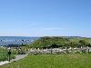
| L'Anse aux Meadows  FeatureType : landmark Elevation : 6 Lat/Lng : 51.5953 / -55.5312 | L'Anse aux Meadows (; a French-English name meaning the bay with the meadows) is an archaeological site on the northernmost tip of the Great Northern Peninsula on the island of Newfoundland in the Canadian province of Newfoundland and Labrador (...) |
| 2 | 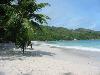
| Praslin FeatureType : isle Elevation : 186 Lat/Lng : -4.3167 / 55.7333 | Praslin is the second largest island (38.5 km2) of the Seychelles, lying northeast of Mahé. Praslin has a population of around 7,533 people and comprises two administrative districts: Baie Sainte Anne and Grand' Anse. The main settlements are the Baie Ste Anne, Anse Volbert and Grand' Anse (...) |
| 3 | 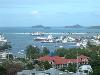
| Mahé, Seychelles FeatureType : isle Elevation : 411 Lat/Lng : -4.6667 / 55.4667 | Mahé is the largest island (157.3 km²) of Seychelles, lying in the northeast of the nation in the Indian Ocean. The population of Mahé was 77,000, as of the 2010 census. It contains the capital city of Victoria and accommodates 86% of the country's total population (...) |
| 4 | Grand'Anse (department) FeatureType : null Lat/Lng : 18.6667 / -74.1167 | Grand'Anse is one of the ten departments of Haiti. Its capital is Jérémie. (...) | |
| 5 | 
| Saint Barthélemy FeatureType : isle Elevation : 12 Lat/Lng : 17.8954 / -62.8276 | Saint Barthélemy , officially the Territorial collectivity of Saint-Barthélemy , called Ouanalao by the indigenous people, is an overseas collectivity of France in the West Indies. Often abbreviated to St-Barth in French, and St. Barths or St. Barts in English, R. P. Raymond BRETON (...) |
| 6 |
| Seychelles FeatureType : country Elevation : 9 Lat/Lng : -7.0675 / 52.7344 | Seychelles (; French:), officially the Republic of Seychelles (; Creole: Repiblik Sesel), is an archipelago country in the Indian Ocean. The capital of the 115-island country, Victoria, lies east of mainland East Africa (...) |
| 7 | 
| La Ciotat FeatureType : null Elevation : 9 Lat/Lng : 43.1735 / 5.6052 | La Ciotat is a commune in the Bouches-du-Rhône department in the Provence-Alpes-Côte d'Azur region in southern France. It is part of the Aix-Marseille-Provence Metropolis. La Ciotat is located to the east of Marseille at an equal distance from Marseille and Toulon (...) |
| 8 | 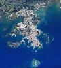
| Nouméa FeatureType : null Elevation : 2 Lat/Lng : -22.2758 / 166.458 | Nouméa is the capital and largest city of the French special collectivity of New Caledonia. It is situated on a peninsula in the south of New Caledonia's main island, Grande Terre, and is home to the majority of the island's European, Polynesian (Wallisians, Futunians, Tahitians), Indonesian, and (...) |
| 9 | 
| Saint Lucia FeatureType : country Elevation : 331 Lat/Lng : 13.8992 / -60.9672 | Saint Lucia is a sovereign island country in the West Indies in the eastern Caribbean Sea on the boundary with the Atlantic Ocean. Part of the Lesser Antilles, it is located north/northeast of the island of Saint Vincent, northwest of Barbados and south of Martinique (...) |
| 10 | 
| Newfoundland (island) FeatureType : isle Elevation : 256 Lat/Lng : 48.5663 / -55.7773 | Newfoundland Both names can be found in ."Ikkarumikluak" means "place of many shoals" while "Kallunasillik" means "place of many white people". It is thought the "Ikkarumiklua" was used before the colonization of Newfoundland and was later replaced by "Kallunasillik" (...) |
| 11 | 
| Réunion FeatureType : adm1st Elevation : 1715 Lat/Lng : -21.1144 / 55.5325 | Réunion (; previously Île Bourbon) is an overseas department and region of France and an island in the Indian Ocean, east of Madagascar and southwest of Mauritius. , it had a population of 865,826. It has the highest per capita GDP in the Indian Ocean (...) |
| 12 | 
| Gonâve Island FeatureType : isle Elevation : 200 Lat/Lng : 18.8333 / -73.0833 | Gonâve Island (; also La Gonâve) is an island of Haiti located west-northwest of Port-au-Prince in the Gulf of Gonâve. It is the largest of the Hispaniolan satellite islands. The island is an arrondissement (Arrondissement de La Gonâve) in the Ouest and includes the communes of Anse-à-Galets and (...) |
| 13 | 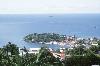
| St. George's, Grenada FeatureType : city Elevation : 114 Lat/Lng : 12.0444 / -61.7417 | St. George's is the capital of Grenada. The town is surrounded by a hillside of an old volcano crater and is on a horseshoe-shaped harbor. St. George's is a popular Caribbean tourist destination. The town has developed in recent years, while preserving its history, culture, and natural environment (...) |
| 14 | 
| Cap-Haïtien FeatureType : null Elevation : 12 Lat/Lng : 19.7599 / -72.2 | Cap-Haïtien often referred to as Le Cap or Au Cap, is a commune of about 190,000 people on the north coast of Haiti and capital of the department of Nord. Previously named, Cap‑Français (initially Cap-François) and Cap‑Henri, it was historically nicknamed, The Paris of the Antilles, because of its (...) |
| 15 | 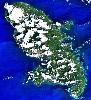
| Martinique FeatureType : isle Elevation : 58 Lat/Lng : 14.6407 / -61.0112 | Martinique is an insular region of France located in the Lesser Antilles of the West Indies in the eastern Caribbean Sea, with a land area of and a population of 385,551 inhabitants as of January 2013. Like Guadeloupe, it is an overseas region of France, consisting of a single overseas department (...) |
| 16 | Grande-Anse, New Brunswick FeatureType : city Elevation : 19 Lat/Lng : 47.8123 / -65.1852 | Grande-Anse (2011 pop.: 738) is a Canadian village in Gloucester County, New Brunswick. It is near the community of Pokeshaw. The village is located on the shore of Chaleur Bay in the Acadian Peninsula region, 25 km northwest of Caraquet and 45 kilometres east of Bathurst (...) | |
| 17 | 
| Rodrigues FeatureType : null Elevation : 229 Lat/Lng : -19.7167 / 63.4167 | Rodrigues is a autonomous outer island of the Republic of Mauritius in the Indian Ocean, about east of Mauritius. It is part of the Mascarene Islands which include Mauritius and Réunion. It is of volcanic origin and is surrounded by coral reef, and just off its coast lie some tiny uninhabited (...) |
| 18 |
| Grenada FeatureType : country Elevation : 294 Lat/Lng : 12.1333 / -61.6833 | Grenada is a country in the West Indies in the Caribbean Sea at the southern end of the Grenadines island chain. Grenada consists of the island of Grenada itself plus six smaller islands which lie to the north of the main island (...) |
| 19 | Anse FeatureType : null Elevation : 179 Lat/Lng : 45.935 / 4.718 | Anse is a commune in the Rhône department in eastern France. It is situated on the river Saône, approx. 7 km south of Villefranche-sur-Saône (near Lyon). (...) | |
| 20 | 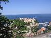
| Monaco FeatureType : city Elevation : 29 Lat/Lng : 43.7325 / 7.4183 | Monaco , officially the Principality of Monaco , is a sovereign city-state, country and microstate on the French Riviera in Western Europe. France borders the country on three sides while the other side borders the Mediterranean Sea (...) |
| 21 | 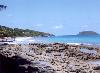
| Guadeloupe FeatureType : adm1st Elevation : 26 Lat/Lng : 16.25 / -61.5833 | Guadeloupe (; ; Antillean Creole: Gwadloup) is an insular region of France located in the Leeward Islands, part of the Lesser Antilles in the Caribbean. Administratively, it is an overseas region consisting of a single overseas department (...) |
| 22 | 
| Saint Pierre and Miquelon FeatureType : adm1st Elevation : 53 Lat/Lng : 46.825 / -56.275 | Saint Pierre and Miquelon, officially the Overseas Collectivity of Saint Pierre and Miquelon , is a self-governing territorial overseas collectivity of France, situated in the northwestern Atlantic Ocean near the Canadian province of Newfoundland and Labrador (...) |
| 23 | 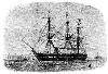
| Kerguelen Islands FeatureType : isle Elevation : 706 Lat/Lng : -49.3334 / 69.3334 | The Kerguelen Islands (or ;, respectively or . in French commonly ' but officially '), also known as the Desolation Islands (' in French), are a group of islands in the Antarctic constituting one of the two exposed parts of the Kerguelen Plateau, a large igneous province mostly submerged by the (...) |
| 24 | 
| Newfoundland and Labrador FeatureType : adm1st Elevation : 63 Lat/Lng : 47.6011 / -52.6976 | Newfoundland and Labrador (; ; Newfoundland Irish:) is the most easterly province of Canada. Situated in the country's Atlantic region, it comprises the island of Newfoundland and mainland Labrador to the northwest, with a combined area of (...) |
| 25 | 
| Ojibwe FeatureType : null Elevation : 188 Lat/Lng : 46.6875 / -92.1892 | The Ojibwe, Ojibwa, Chippewa, or Saulteaux are an Anishinaabeg group of Indigenous Peoples in North America, which is referred to by many of its Indigenous peoples as Turtle Island. They live in Canada and the United States and are one of the largest Indigenous ethnic groups north of the Rio Grande (...) |
| 26 | 
| Canada FeatureType : country Elevation : 73 Lat/Lng : 45.4116 / -75.6984 | Canada is a country located in the northern part of North America. Its ten provinces and three territories extend from the Atlantic to the Pacific and northward into the Arctic Ocean, covering , making it the world's second-largest country by total area (...) |
| 27 | 
| Îles des Saintes FeatureType : isle Lat/Lng : 15.8611 / -61.6098 | The Îles des Saintes ("Islands of the Saints"), also known as Les Saintes, is a small archipelago of the French Antilles (West Indies) located to the south of Basse-Terre Island, west of Marie-Galante and north of Dominica (...) |
| 28 | 
| Haiti FeatureType : country Elevation : 38 Lat/Lng : 18.5392 / -72.3364 | Haiti , officially the Republic of Haiti and formerly called Hayti, is a country located on the island of Hispaniola, east of Cuba in the Greater Antilles archipelago of the Caribbean Sea. It occupies the western three-eighths of the island, which it shares with the Dominican Republic (...) |
| 29 | 
| Nantes FeatureType : null Elevation : 20 Lat/Lng : 47.2181 / -1.5528 | Nantes (Gallo: Naunnt or Nantt (or); is a city in Loire-Atlantique on the Loire, from the Atlantic coast. The city is the sixth-largest in France, with a population of nearly 300,000 in Nantes and a metropolitan area of 908,815 inhabitants (...) |
| 30 | Corail Arrondissement FeatureType : null Elevation : 60 Lat/Lng : 18.5667 / -73.8833 | Corail is an arrondissement of the Grand'Anse department, located in southwestern Haiti. As of 2015, the population was 131,561 inhabitants. Postal codes in the Anse d'Hainault Arrondissement start with the number 73. (...) | |
| 31 | 
| Sainte-Anne-de-Bellevue, Quebec FeatureType : null Elevation : 31 Lat/Lng : 45.4064 / -73.951 | Sainte-Anne-de-Bellevue is an on-island suburb located at the western tip of the Island of Montreal in southwestern Quebec, Canada. It is the second oldest community in Montreal's West Island, having been founded as a parish in 1703. The oldest, Dorval, was founded in 1667 (...) |
| 32 | L'Anse, Michigan FeatureType : city Elevation : 679 Lat/Lng : 46.7533 / 88.4458 | L'Anse is a village in northwest Michigan, United States, and the county seat of Baraga County. The population was 2,011 at the 2010 census. The village is located within L'Anse Township. In French, L'Anse translates as "the cove", a reference to its location on Keweenaw Bay, at the base of the (...) | |
| 33 | 
| St. Clair Shores, Michigan FeatureType : null Elevation : 179 Lat/Lng : 42.4956 / -82.9003 | St. Clair Shores is a suburban city bordering Lake St. Clair in Macomb County of the U.S. state of Michigan. It forms a part of the Metro Detroit area, and is located approximately northeast of downtown Detroit. The population was 59,715 at the 2010 census. The current mayor is Kip C (...) |
| 34 | Baraga County, Michigan FeatureType : adm2nd Elevation : 405 Lat/Lng : 46.72 / -88.34 | Baraga County is a county in the Upper Peninsula in the U.S. state of Michigan. As of the 2010 United States Census, the population was 8,860. The county seat is L'Anse. The county is named after Bishop Frederic Baraga, a Catholic missionary who ministered to indigenous peoples of the area during (...) | |
| 35 | Anse d'Hainault Arrondissement FeatureType : null Elevation : 307 Lat/Lng : 18.5167 / -74.3667 | Anse d'Hainault is an arrondissement of the Grand'Anse Department located in southwestern Haiti. As of 2015, the population was 98,522 inhabitants. Postal codes in the Anse d'Hainault Arrondissement start with the number 72. (...) | |
| 36 | Jérémie Arrondissement FeatureType : null Elevation : 49 Lat/Lng : 18.6413 / -74.1179 | Jérémie is an arrondissement in the Grand'Anse Department of Haiti. As of 2015, the population was 238,218 inhabitants. Postal codes in the Anse d'Hainault Arrondissement start with the number 71. (...) | |
| 37 | Anse la Raye Quarter FeatureType : adm1st Elevation : 223 Lat/Lng : 13.9167 / -61.0139 | Anse la Raye is a Quarter on the West coast of St. Lucia in the Caribbean Sea. In 2001, the population of the region was 6,071 people, and they are mainly fishers and agricultural workers. The main town in the area takes the same name as the Quarter and is located at , down the western coast from (...) | |
| 38 | Canton of Anse FeatureType : null Elevation : 185 Lat/Lng : 45.92 / 4.71 | The Canton of Anse is a French administrative division, located in the Rhône department. The canton was modified by decree of 27 February 2014 which came into force in March 2015. (...) | |
| 39 | Azergues FeatureType : null Elevation : 168 Lat/Lng : 45.9417 / 4.7292 | The Azergues is a river in the Rhône department, in eastern France. It is a right tributary of the Saône, which it joins in Anse. Its source is in the Beaujolais hills, near Chénelette. The Azergues flows through the following towns: Lamure-sur-Azergues, Le Bois-d'Oingt, Chessy, Châtillon, (...) | |
| 40 | Belle-Anse Arrondissement FeatureType : null Lat/Lng : 18.2331 / -72.0669 | Belle-Anse is an arrondissement in the Sud-Est department of Haiti. As of 2015, the population was 158,081 inhabitants. Postal codes in the Belle-Anse Arrondissement start with the number 93. The arondissement consists of the following communes: * Belle-Anse * Anse-à-Pitres * Grand-Gosier * Thiotte (...) | |
| 41 | Anse-Bertrand FeatureType : null Elevation : 17 Lat/Lng : 16.4722 / -61.5072 | Anse-Bertrand is a commune in Guadeloupe, an overseas region and department of France in the Lesser Antilles. The inhabitants in Anse-Bertrand are called Ansois. (...) | |
| 42 | 
| Futuna (Wallis and Futuna) FeatureType : isle Elevation : 352 Lat/Lng : -14.2833 / -178.1167 | Futuna is an 80 km2 island with 5,000 people and max. elevation of 500 m in the Pacific Ocean, belonging to the French overseas collectivity (collectivité d'outre-mer, or COM) of Wallis and Futuna. It is one of the Hoorn Islands or Îles Horne, nearby Alofi being the other (...) |
| 43 | L'Anse-Saint-Jean, Quebec FeatureType : null Elevation : 20 Lat/Lng : 48.2331 / -70.2049 | L'Anse-Saint-Jean, French for "The Cove of Saint John" is a municipality in the Saguenay-Lac-Saint-Jean region of Quebec, Canada. Its population was 1208 in the Canada 2011 Census. L'Anse-Saint-Jean was founded in 1838 by the Société des Vingt-et-un, a group of lumber prospectors and investors from (...) | |
| 44 | 
| La Digue FeatureType : isle Elevation : 80 Lat/Lng : -4.3667 / 55.8333 | La Digue is the third largest inhabited island of the Seychelles in terms of population, lying east of Praslin and west of Felicite Island. In terms of size it is the fourth largest granitic island of Seychelles after Mahé, Praslin and Silhouette Island (...) |
| 45 | 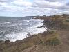
| Cape Breton Highlands National Park FeatureType : forest Elevation : 486 Lat/Lng : 46.73 / -60.6422 | Cape Breton Highlands National Park (official name: Cape Breton Highlands National Park of Canada) is a Canadian national park located on northern Cape Breton Island in the province of Nova Scotia. One-third of the Cabot Trail passes through the park featuring spectacular ocean and mountain views (...) |
| 46 | Anse-à-Veau Arrondissement FeatureType : null Lat/Lng : 18.5167 / -73.35 | Anse-à-Veau is an arrondissement in the Nippes Department of Haiti. As of 2015, the population was 153,639 inhabitants. Postal codes in the Anse-à-Veau Arrondissement start with the number 75. The arondissement consists of the following communes: * Anse-à-Veau * Arnaud * L'Asile * (...) | |
| 47 | Sud-Est (department) FeatureType : null Elevation : 30 Lat/Lng : 18.2333 / -72.5333 | Sud-Est is one of the ten departments of Haiti. It has an area of 2,034.10 km² and a population of 632,601 (2015). Its capital is Jacmel. (...) | |
| 48 | Anse-d'Hainault FeatureType : null Elevation : 24 Lat/Lng : 18.5 / -74.45 | Anse-d'Hainault is a commune in the Anse-d'Hainault Arrondissement, in the Grand'Anse department of Haiti. Towns and villages in Anse-d'Hainault include: Anse-d'Hainault, Decotelette, Dossous, Duchanino, Escamel and Peligrin. (...) | |
| 49 | Anse-à-Foleur FeatureType : null Lat/Lng : 19.9 / -72.6167 | Anse-à-Foleur is a commune in the Saint-Louis-du-Nord Arrondissement, in the Nord-Ouest department of Haiti. (...) | |
| 50 | 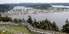
| Placentia, Newfoundland and Labrador FeatureType : city Elevation : 4 Lat/Lng : 47.2379 / -53.9723 | Placentia is a town located in the province of Newfoundland and Labrador Canada, It consists of the "Argentia Industrial Park" and amalgamated communities of Townside, Freshwater, Dunville, and Jerseyside. (...) |
| 51 | Anse La Raye FeatureType : city Elevation : 6 Lat/Lng : 13.9401 / -61.0431 | Anse La Raye or Anse-La-Raye is the largest town in Anse la Raye Quarter, Saint Lucia. It is located on the island's western side, near Marigot Bay, and has several examples of French and English colonial architecture (...) | |
| 52 | Arnaud, Nippes FeatureType : null Elevation : 117 Lat/Lng : 18.45 / -73.3833 | Arnaud is a commune in the Anse-à-Veau Arrondissement, in the Nippes department of Haiti. (...) | |
| 53 | Jérémie FeatureType : null Elevation : 23 Lat/Lng : 18.644 / -74.1145 | Jérémie is a commune and capital city of the Grand'Anse department in Haiti. It had a population of about 31,000 at the 2003 census. It is relatively isolated from the rest of the country. The Grande-Anse River flows near the city (...) | |
| 54 | Gaspé, Quebec FeatureType : null Elevation : 23 Lat/Lng : 48.831 / -64.4844 | Gaspé is a city at the tip of the Gaspé Peninsula in the Gaspésie–Îles-de-la-Madeleine region of eastern Quebec in Canada. Gaspé is located about northeast of Quebec City, and east of Rimouski. As of the Canada 2011 Census, the city had a total population of 15,163 (...) | |
| 55 | Anse-à-Pitres FeatureType : null Elevation : 19 Lat/Lng : 18.0431 / -71.7583 | Anse-à-Pitres , or Anse-à-Pitre is a commune in the Belle-Anse Arrondissement, in the Sud-Est department of Haiti. Its border crossing to Pedernales is one of the four chief land crossings to the Dominican Republic. (...) | |
| 56 | Anse Etoile FeatureType : adm1st Elevation : 185 Lat/Lng : -4.5833 / 55.45 | Anse Etoile is an administrative district of Seychelles on the island of Mahé. | |
| 57 | 
| Skálholt FeatureType : city Lat/Lng : 64.1167 / -20.5333 | Skálholt (Old Icelandic: Skálaholt) is a historical site in the south of Iceland, at the river Hvítá. (...) |
| 58 | Bouillante FeatureType : null Elevation : 6 Lat/Lng : 16.1319 / -61.77 | Bouillante is a commune in the French overseas region and department of Guadeloupe, in the Lesser Antilles. (...) | |
| 59 | Anse-aux-Pins FeatureType : adm1st Elevation : 25 Lat/Lng : -4.6892 / 55.5253 | Anse-aux-Pins is an administrative district of Seychelles located on the island of Mahé. Soleil Island is part of the district. (...) | |
| 60 | Grand'Anse Praslin FeatureType : adm1st Elevation : 11 Lat/Lng : -4.3311 / 55.7222 | Grand'Anse Praslin is an administrative district of Seychelles located mostly on the island of Praslin, but also administers Cousin Island, Cousine Island, Booby Island, and Aride Island. | |
| 61 | Abricots FeatureType : null Elevation : 157 Lat/Lng : 18.6333 / -74.3 | Abricots is a commune in the Jérémie Arrondissement, in the Grand'Anse department of Haiti. Villages located within the municipality include: Abricots, Anse du Clerc, Anse Josep, L'Homond, Latitte, Louissant, Morne Bijote, Poyrette, Sajote, and Saint-Victor (...) | |
| 62 | Lozanne FeatureType : null Elevation : 210 Lat/Lng : 45.8581 / 4.6817 | Lozanne is a commune in the Rhône department in eastern France. Its inhabitants are called Lozannais. (...) | |
| 63 | Les Méchins, Quebec FeatureType : null Elevation : 273 Lat/Lng : 48.9342 / -66.9035 | Les Méchins is a municipality in Quebec, Canada, about east of Matane along Quebec Route 132. In addition to Les Méchins (formerly known as Grands-Méchins) itself, the municipality also includes the communities of Anse-des-Méchins, Cherbourg, Cherbourg-Centre, Les Îlets Méchins, and Petits-Méchins (...) | |
| 64 | Saint Andrew Parish, Dominica FeatureType : null Elevation : 240 Lat/Lng : 15.5667 / -61.3667 | Saint Andrew is one of Dominica's 10 administrative parishes. It is bordered by St. John and St. Peter (to the west), St. Joseph (to the southwest), and St. David (to the southeast). At 178.27 km² (68.83 mi²),Figures provided by the Lands and Surveys Division of the Ministry of Agriculture, Cork (...) | |
| 65 | Florac FeatureType : null Elevation : 654 Lat/Lng : 44.3272 / 3.5992 | Florac is a former commune of the Lozère department in southern France. On 1 January 2016, it was merged into the new commune of Florac-Trois-Rivières. 2–14 December 2015 (...) | |
| 66 | Thiotte FeatureType : null Elevation : 893 Lat/Lng : 18.2415 / -71.8408 | Thiotte is a commune in the Belle-Anse Arrondissement, in the Sud-Est department of Haiti. It has 23,041 inhabitants. (...) | |
| 67 | Petit-Saguenay, Quebec FeatureType : null Elevation : 117 Lat/Lng : 48.2167 / -70.0667 | Petit-Saguenay is a municipality in the Canadian province of Quebec, located in Le Fjord-du-Saguenay Regional County Municipality. The municipality, located on Route 170 near L'Anse-Saint-Jean, had a population of 828 in the Canada 2001 Census, which dropped to 780 in the 2006 census. (...) | |
| 68 | Anse-Bleue, New Brunswick FeatureType : null Elevation : 3 Lat/Lng : 47.8284 / -65.082 | Anse-Bleue is a community in the Canadian province of New Brunswick. The small community is located in New Bandon Parish in Gloucester County, northern New Brunswick, on the southern shore of Chaleur Bay. Most of the population is of Acadian descent and is located along the beach. (...) | |
| 69 | Anse Mamin FeatureType : null Lat/Lng : 13.8706 / -61.0795 | Anse Mamin is a small black sand beach in Saint Lucia. It is located near Anse Chastanet and the two beaches are linked by a rocky path below the cliffs. Anse Mamin offers of wooded trails. (...) | |
| 70 | La Tremblade FeatureType : null Elevation : 6 Lat/Lng : 45.7694 / -1.1417 | La Tremblade is a commune in the Charente-Maritime department and Nouvelle-Aquitaine region in south-western France. (...) | |
| 71 | Mingo County, West Virginia FeatureType : adm2nd Elevation : 385 Lat/Lng : 37.73 / -82.14 | Mingo County is a county in the U.S. state of West Virginia. As of the 2010 census, the population was 26,839. Its county seat is Williamson. Created in 1895, Mingo is West Virginia's newest county, named for the historic Iroquoian Mingo people. (WV County Etymology) (...) | |
| 72 | Battle of the Plains of Abraham FeatureType : null Elevation : 90 Lat/Lng : 46.803 / -71.215 | The Battle of the Plains of Abraham, also known as the Battle of Quebec (Bataille des Plaines d'Abraham, or Première bataille de Québec in French), was a pivotal battle in the Seven Years' War (referred to as the French and Indian War to describe the North American theatre) (...) | |
| 73 | Houghton County, Michigan FeatureType : adm2nd Elevation : 257 Lat/Lng : 46.98 / -88.65 | Houghton County is a county in the Upper peninsula in the U.S. state of Michigan. As of the 2010 United States Census, the population was 36,628. The county seat is Houghton. The county was named for geologist and Detroit Mayor Douglass Houghton (...) | |
| 74 | L'Anse Township, Michigan FeatureType : null Elevation : 351 Lat/Lng : 46.7281 / -88.3717 | L'Anse Township is a civil township of Baraga County in the U.S. state of Michigan. As of the 2010 census, the township population was 3,843. Mount Arvon and Mount Curwood, the highest and second highest points in Michigan, are located in the township. (...) | |
| 75 | Soufrière Quarter FeatureType : null Elevation : 194 Lat/Lng : 13.85 / -61.0333 | Soufrière is a quarter on the Southwest coast of Saint Lucia in the West Indies. Soufrière was the former capital of Saint Lucia during times of French rule. It is now a small fishing port with an emerging tourism industry (...) | |
| 76 | European route E15 FeatureType : landmark Elevation : 132 Lat/Lng : 42.4244 / 2.8658 | The European route E 15 is part of the United Nations international E-road network. It is a north-south "reference road", running from Inverness, Scotland south through England and France to Algeciras, Spain., 5 April 2002 Along most of its route between Paris and London, the road parallels the LGV (...) | |
| 77 | Pestel, Grand'Anse FeatureType : null Elevation : 149 Lat/Lng : 18.5333 / -73.8 | Pestel is a commune in the Corail Arrondissement, in the Grand'Anse department of Haiti. It has 36,138 inhabitants. The commune also includes the Cayemite Islands. (...) | |
| 78 | Little Anse, Nova Scotia FeatureType : null Elevation : 7 Lat/Lng : 45.5112 / -61.0129 | Little Anse (also known as Petite Anse and Petit Anse) is a small community in the Canadian province of Nova Scotia, located in Richmond County. The village of Petite Anse is one of the oldest communities in Isle Madame, in Cape Breton, dating back to the 18th century. | |
| 79 | Saint-Jean-Cap-Ferrat FeatureType : null Elevation : 48 Lat/Lng : 43.6833 / 7.3333 | Saint-Jean-Cap-Ferrat , Italian: San Giovanni Capo Ferrato) is a commune of the Alpes-Maritimes department in southeastern France. It is located on a peninsula next to Beaulieu-sur-Mer and Villefranche-sur-Mer and extends out to Cap Ferrat (...) | |
| 80 | Terre-de-Haut Island FeatureType : isle Elevation : 6 Lat/Lng : 15.8668 / -61.5824 | Terre-de-Haut Island (officially in French :Terre-de-Haut des Saintes (literally: highland of les Saintes)) is an island in the Îles des Saintes archipelago, in the Lesser Antilles. It belongs to the commune (municipality) of Terre-de-Haut into the French department of Guadeloupe. (...) | |
| 81 | Trois-Rivières, Guadeloupe FeatureType : null Elevation : 116 Lat/Lng : 15.9764 / -61.6447 | Trois-Rivières is a commune in the overseas department of Guadeloupe, and the chef-lieu of the Canton of Trois-Rivières. It is on the south coast of the island of Basse-Terre. It is surrounded with the towns of Capesterre-Belle-Eau, Vieux-Fort and Gourbeyre. (...) | |
| 82 | Trois-Rives, Quebec FeatureType : null Elevation : 345 Lat/Lng : 47.0 / -72.75 | Trois-Rives is a municipality with an area of located in Mékinac Regional County Municipality, in the Mid-Mauricie, province of Quebec, Canada. It is bounded on the west by the Saint-Maurice River, and includes the communities of Grande-Anse, Olscamps, Rivière Matawin (Hamlet), (...) | |
| 83 | Allier (river) FeatureType : null Elevation : 164 Lat/Lng : 46.9594 / 3.0789 | The Allier is a river in central France. It is a left tributary of the Loire. Its source is in the Massif Central, in the Lozère department, east of Mende. It flows generally north. It joins the Loire west of the city of Nevers. It is long, and has a drainage basin of . (...) | |
| 84 | Nunavut FeatureType : adm1st Lat/Lng : 73.0 / -91.0 | Nunavut (; ; Inuktitut syllabics) is the newest, largest, and northernmost territory of Canada. It was separated officially from the Northwest Territories on April 1, 1999, via the Nunavut Act and the Nunavut Land Claims Agreement Act, though the boundaries had been contemplatively drawn in 1993 (...) | |
| 85 | Kelowna FeatureType : city Elevation : 360 Lat/Lng : 49.8819 / -119.4545 | Kelowna is a city on Okanagan Lake in the Okanagan Valley in the southern interior of British Columbia, Canada. It serves as the head office of the Regional District of the Central Okanagan. The name Kelowna derives from an Okanagan language term for "grizzly bear" (...) | |
| 86 | Houghton, Michigan FeatureType : null Elevation : 262 Lat/Lng : 47.1172 / -88.5625 | Houghton is a city in the U.S. state of Michigan's Upper Peninsula and largest city in the Copper Country on the Keweenaw Peninsula. As of the 2010 census, the city population was 7,708. It is the county seat of Houghton County. It has been listed as one of the "100 Best Small Towns in America (...) | |
| 87 | Belle-Anse FeatureType : null Elevation : 7 Lat/Lng : 18.238 / -72.062 | Belle-Anse is a commune in the Belle-Anse Arrondissement, in the Sud-Est department of Haiti. It has 51,707 inhabitants. (...) | |
| 88 | 
| Silhouette Island FeatureType : isle Elevation : 562 Lat/Lng : -4.48 / 55.2358 | Silhouette Island lies northwest of Mahé in the Seychelles. It is the third largest granitic island in the Seychelles. It has an area of 20.1 km2 and has a population of 200, mostly workers on the island. The main settlement is La Passe, where Hilton Hotel is located (...) |
| 89 | Arrondissement of Villefranche-sur-Saône FeatureType : adm3rd Elevation : 178 Lat/Lng : 45.9889 / 4.7236 | The arrondissement of Villefranche-sur-Saône is an arrondissement of France in the Rhône department in the Auvergne-Rhône-Alpes region. On 1 February 2017, 78 communes passed from the arrondissement of Villefranche-sur-Saône to the arrondissement of Lyon (...) | |
| 90 | Nord-Ouest (department) FeatureType : null Lat/Lng : 19.95 / -72.8333 | Nord-Ouest is one of the ten departments of Haiti as well as the northernmost one. It has an area of 2,102.88 km² and a population of 728,807 (2015 Census). Its capital is Port-de-Paix. (...) | |
| 91 | 
| Avery Island, Louisiana FeatureType : isle Elevation : 17 Lat/Lng : 29.8967 / -91.9089 | Avery Island (historically) is a salt dome best known as the source of Tabasco sauce. Located in Iberia Parish, Louisiana, United States, it is approximately inland from Vermilion Bay, which in turn opens onto the Gulf of Mexico. A small human population lives on the island (...) |
| 92 | L'Anse-au-Loup FeatureType : null Elevation : 29 Lat/Lng : 51.5168 / -56.8314 | L'Anse-au-Loup is a town in the Canadian province of Newfoundland and Labrador. The town had a population of 558 in the Canada 2016 Census, slightly up from 550 in 2011. In the Canada 2006 Census, there were 593 inhabitants (...) | |
| 93 | Nippes FeatureType : city Lat/Lng : 18.45 / -73.1 | Nippes is one of the ten departments of Haiti. It is the most recent department, having been split from Grand'Anse in 2003. The capital of the department is Miragoâne. (...) | |
| 94 | Bathurst, New Brunswick FeatureType : city Elevation : 7 Lat/Lng : 47.6175 / -65.6491 | Bathurst (2011 population; UA 12,275; CA population 13,424) is the county seat for Gloucester County, New Brunswick, and is at the estuary of the Nepisiguit River. (...) | |
| 95 | Americas FeatureType : country Elevation : 35 Lat/Lng : 19.0 / -96.0 | The Americas (also collectively called America; , Spanish/Portuguese: América) comprise the totality of the continents of North and South America.Webster's New World College Dictionary, 2010 by Wiley Publishing, Inc., Cleveland, Ohio."continent n. 5. a." (1989) Oxford English Dictionary, 2nd edition (...) | |
| 96 | North America FeatureType : null Elevation : 453 Lat/Lng : 48.1667 / -100.1667 | North America is a continent entirely within the Northern Hemisphere and almost all within the Western Hemisphere; it is also considered by some to be a northern subcontinent of the Americas. It is bordered to the north by the Arctic Ocean, to the east by the Atlantic Ocean, to the west and south by (...) | |
| 97 | Grand'Anse Mahé FeatureType : null Elevation : 259 Lat/Lng : -4.6667 / 55.45 | Grand'Anse Mahé is an administrative district of Seychelles located on the island of Mahé. | |
| 98 | Anse-Rouge FeatureType : null Elevation : 7 Lat/Lng : 19.6318 / -73.0561 | Anse-Rouge is a commune in the Gros-Morne Arrondissement, in the Artibonite department of Haiti. (...) | |
| 99 | Saint-Maxime-du-Mont-Louis, Quebec FeatureType : null Lat/Lng : 49.2333 / -65.7333 | Saint-Maxime-du-Mont-Louis is a municipality in Quebec, Canada. Located in the administrative region of Gaspésie–Îles-de-la-Madeleine and the regional county municipality of La Haute-Gaspésie, the municipality comprises the communities of Mont-Louis, Ruisseau-des-Olives, L'Anse-Pleureuse, Les (...) | |
| 100 | Murdochville, Quebec FeatureType : null Elevation : 805 Lat/Lng : 48.9604 / -65.4797 | Murdochville is a town in Quebec, Canada, one of only a few inland communities on the Gaspé Peninsula. Its population (as of 2011) is 764. Murdochville is located along Quebec Route 198 in the geographic township of Holland, south of L'Anse-Pleureuse and west of Gaspé (...) | |
| 101 | Anse du Mé FeatureType : city Elevation : 108 Lat/Lng : 15.5833 / -61.3667 | Anse de Mai is a fishing village in the northeast of Dominica, located between the towns of Calibishie and Portsmouth. In 2013 Atlantique View Resort & Spa opened in Anse de Mai. | |
| 102 | Deshaies FeatureType : null Elevation : 9 Lat/Lng : 16.3069 / -61.7942 | Deshaies (French:) is a commune in the French overseas region and department of Guadeloupe, in the Lesser Antilles. It is on the northwest coast of Basse-Terre Island. The inhabitants are called Deshaisiens. (...) | |
| 103 | Ouest (department) FeatureType : null Elevation : 70 Lat/Lng : 18.573 / -72.24 | Ouest is one of the ten departments of Haiti. It is the jurisdictional seat of the national capital, the city of Port-au-Prince. It has an area of and a population of 4,029,705 (2015 Estimate). It borders the Dominican Republic to the east (...) | |
| 104 | Mékinac Regional County Municipality FeatureType : null Elevation : 150 Lat/Lng : 46.8167 / -72.5167 | Mékinac is a regional county municipality (MRC) in the administrative region of Mauricie, in the province of Quebec, Canada. Its seat is Saint-Tite. It is composed of 10 municipalities and 4 unorganized territories. (...) | |
| 105 | Le Fjord-du-Saguenay Regional County Municipality FeatureType : null Elevation : 545 Lat/Lng : 49.2499 / -70.8309 | Le Fjord-du-Saguenay (The Fjord of the Saguenay) is a regional county municipality in the Saguenay-Lac-Saint-Jean region of Quebec, Canada. Its seat is Saint-Honoré, which is also its most populous municipality (...) | |
| 106 | Grande-Anse FeatureType : null Lat/Lng : 10.3327 / -60.9696 | Grande-Anse, Grand'Anse, or Grand Anse is a proper name that may refer to several places: *Grande-Anse River, Haiti *Grand'Anse (department), an administrative subdivision of Haiti *Grande-Anse, Quebec, a hamlet in Mauricie, Québec, Canada *Grande-Anse, New Brunswick, a village of New-Brunswick, (...) | |
| 107 | Sainte-Anne-des-Monts, Quebec FeatureType : null Lat/Lng : 49.1333 / -66.5 | Sainte-Anne-des-Monts is a city in the Gaspésie–Îles-de-la-Madeleine region of the province of Quebec in Canada. Sainte-Anne-des-Monts, a small city between the Chic-Choc Mountains and sea, it is on the south shore of the St-Lawrence river estuary (...) | |
| 108 | Percé, Quebec FeatureType : null Elevation : 36 Lat/Lng : 48.5623 / -64.3257 | Percé is a small city near the tip of the Gaspé Peninsula in Quebec, Canada. Within the territory of the city there is a village community also called Percé. Percé, member of the association of Most Beautiful Villages of Quebec, is mainly a tourist location particularly well known for the (...) | |
| 109 | Terre-de-Bas FeatureType : null Elevation : 43 Lat/Lng : 15.8497 / -61.6436 | Terre-de-Bas is a commune in the French overseas department and region of Guadeloupe, in the Lesser Antilles. Terre-de-Bas is made up of Terre-de-Bas Island and several uninhabited islands and islets in the group of Les Saintes islands, to the southwest of Guadeloupe's mainland. (...) | |
| 110 | Division No. 10, Newfoundland and Labrador FeatureType : adm2nd Elevation : 490 Lat/Lng : 53.2837 / -59.64 | Census Division No. 10 is composed of the area of the province of Newfoundland and Labrador, Canada, called Labrador outside Nunatsiavut. It has a land area of 269,073.3 km² (103,889.78 sq mi) and at the 2011 census had a population of 24,111 (...) | |
| 111 | La Baie, Quebec FeatureType : null Elevation : 5 Lat/Lng : 48.3378 / -70.8794 | La Baie (French pronunciation: /la bɛ/, Quebec French pronunciation: /la be/) is one of three boroughs in the city of Saguenay, Quebec, Canada. It was created during Quebec's municipal reorganization in 2002. From 1976 to 2001, it was known as the Town of La Baie, a municipality composed of the (...) | |
| 112 | Anse-à-Galets FeatureType : null Elevation : 24 Lat/Lng : 18.8333 / -72.8667 | Anse-à-Galets is a commune and city in the La Gonâve Arrondissement, in the Ouest department on Gonâve Island in Haiti, located to the west-northwest of Port-au-Prince in the Gulf of Gonâve. It is the largest commune on the island and has 62,559 inhabitants (...) | |
| 113 | Anse Chastanet FeatureType : null Elevation : 20 Lat/Lng : 13.8647 / -61.0777 | null | |
| 114 | Terre-de-Bas Island FeatureType : isle Elevation : 231 Lat/Lng : 15.8542 / -61.6328 | Terre-de-Bas Island (officially in French: Terre-de-Bas des Saintes (literally: Lowland of les Saintes)) is an island in the Îles des Saintes archipelago, in the Lesser Antilles. It belongs to the commune (municipality) of Terre-de-Bas in the French department of Guadeloupe. (...) | |
| 115 | L'Anse-au-Clair FeatureType : null Elevation : 152 Lat/Lng : 51.4636 / -57.0672 | L'Anse-au-Clair is a town in the Labrador portion of Newfoundland and Labrador, Canada. The town has a population of 216 in the 2016 census, up from 192 in 2011. It is located on Route 510, about 3 km from the Quebec–Labrador border. It was established by the French in the early 18th century (...) | |
| 116 | Forteau FeatureType : null Elevation : 4 Lat/Lng : 51.4733 / -56.9573 | Forteau is a town in the Canadian province of Newfoundland and Labrador. The town had a population of 448 as of the Canada 2006 Census. The town is located along Route 510 in Labrador, between L'Anse-au-Clair and L'Anse-au-Loup. There is a health centre, a post office and a variety of shops (...) | |
| 117 | Grande-Vallée, Quebec FeatureType : null Elevation : 4 Lat/Lng : 49.2168 / -65.132 | Grande-Vallée is a municipality in the Gaspésie-Îles-de-la-Madeleine region of the province of Quebec in Canada. Its name (French for "Great Valley") describes its location in a large fertile valley through which the Grand Vallée River flows. (...) | |
| 118 | Rivière-Ouelle FeatureType : null Lat/Lng : 47.473 / -70.0359 | Rivière-Ouelle is a town located in the Kamouraska Regional County Municipality within the Bas-Saint-Laurent region of Quebec. It is located on the Saint Lawrence River; the Ouelle River flows through the town. It was part of the seignory of La Bouteillerie, once owned by Charles Deschamps de (...) | |
| 119 | Anse-à-Veau FeatureType : null Lat/Lng : 18.5167 / -73.35 | Anse-à-Veau is a commune in the Anse-à-Veau Arrondissement, in the Nippes department of Haiti. The postal code is HT 7510. In the aftermath of the 2010 Haiti earthquake, Anse-a-Veau was swollen by refugees from the afflicted areas. Aid to the community after the quake have been airdropped (...) | |
| 120 | Petit-Trou-de-Nippes FeatureType : null Elevation : 6 Lat/Lng : 18.5254 / -73.5081 | Petit-Trou-de-Nippes is a commune in the Anse-à-Veau Arrondissement, in the Nippes department of Haiti. It has 36,143 inhabitants. (...) | |
| 121 | Plaisance-du-Sud FeatureType : null Elevation : 383 Lat/Lng : 18.4333 / -73.6167 | Plaisance-du-Sud is a commune in the Anse-à-Veau Arrondissement, in the Nippes department of Haiti. (...) | |
| 122 | Moron, Grand'Anse FeatureType : null Elevation : 76 Lat/Lng : 18.5576 / -74.2576 | Moron is a commune in the Jérémie Arrondissement, in the Grand'Anse department of Haiti. It has 24,713 inhabitants (in 2003). Villages located within the commune include: Moron, Gros Morne, La Roche, Layalace, Lenaire, Plik and Sources Chaudes. (...) | |
| 123 | Anse Du Mé River FeatureType : river Lat/Lng : 15.6 / -61.3833 | The Anse Du Mé River is a river on the Caribbean island of Dominica. (...) | |
| 124 | Beaumont, Grand'Anse FeatureType : null Elevation : 595 Lat/Lng : 18.4833 / -73.9667 | Beaumont is a commune in the Corail Arrondissement, in the Grand'Anse department of Haiti. It has 12,486 inhabitants. Locations in Beaumont commune include: Beaumont, Flandre and Lacadome. (...) | |
| 125 | L'Anse-au-Diable FeatureType : null Elevation : 8 Lat/Lng : 51.5616 / -56.761 | L'Anse-au-Diable was a small settlement located south west of Red Bay, Newfoundland and Labrador. (...) | |
| 126 | Caraquet (electoral district) FeatureType : null Elevation : 29 Lat/Lng : 47.731 / -64.991 | Caraquet is a provincial electoral district for the Legislative Assembly of New Brunswick, Canada. It was created in 1973 from Gloucester. The riding is centred on the town of Caraquet, extending west to Grande-Anse, New Brunswick and Saint-Léolin, New Brunswick and south to Paquetville, New (...) | |
| 127 | Grand-Bourg FeatureType : null Elevation : 8 Lat/Lng : 15.8833 / -61.3167 | Grand-Bourg is a commune on the island of Marie-Galante, in the French overseas region and department of Guadeloupe in the Lesser Antilles Caribbean. It is located in the southwest of Marie-Galante, and is the most populous of the three communes on the island (...) | |
| 128 | Nicolet, Quebec FeatureType : null Elevation : 15 Lat/Lng : 46.2183 / -72.619 | Nicolet, Quebec is the county seat of Nicolet-Yamaska Regional County Municipality, Quebec, Canada. The population as of the Canada 2011 Census was 7,828. It is the seat of the Roman Catholic Diocese of Nicolet (...) | |
| 129 | Logan, West Virginia FeatureType : city Elevation : 239 Lat/Lng : 37.8483 / -81.9878 | Logan is a city in Logan County, West Virginia, United States, along the Guyandotte River. The population was 1,779 at the 2010 census. It is the county seat of Logan County. (...) | |
| 130 | Seychelles International Airport FeatureType : airport Elevation : -2 Lat/Lng : -4.6743 / 55.5219 | Seychelles International Airport , or Aéroport de la Pointe Larue in French, is the international airport of the Seychelles located on the island of Mahé near the capital city of Victoria. The airport is the home base and the head office of Air Seychelles" ." Air Seychelles (...) | |
| 131 | Grand Banks of Newfoundland FeatureType : null Lat/Lng : 45.2369 / -50.9892 | The Grand Banks of Newfoundland are a group of underwater plateaus south-east of Newfoundland on the North American continental shelf. These areas are relatively shallow, ranging from in depth. The cold Labrador Current mixes with the warm waters of the Gulf Stream here (...) | |
| 132 | 
| Assumption Island FeatureType : isle Elevation : 10 Lat/Lng : -9.7316 / 46.5145 | Assumption Island is a small island in the Outer Islands of Seychelles north of Madagascar, with a distance of south-west of the capital, Victoria, on Mahé Island. In 2018, Seychelles and India signed an agreement to build and operate a joint military facility on a portion of the island (...) |
| 133 | Area code 506 FeatureType : null Elevation : 96 Lat/Lng : 46.516 / -66.284 | Area code 506 is the telephone area code in the Canadian province of New Brunswick, encompassing the entire province. The code was created in 1955, when New Brunswick and Newfoundland (including Labrador) split from the 902 area code; Newfoundland and Labrador split to its own 709 area code in early (...) | |
| 134 | L'Anse Indian Reservation FeatureType : null Elevation : 270 Lat/Lng : 46.7811 / -88.4022 | The L'Anse Indian Reservation is the land base of the federally recognized Keweenaw Bay Indian Community of the historic Lake Superior Band of Chippewa Indians. (The Keweenaw Bay Indian Community was defined in 1934 by the Indian Reorganization Act as the successor apparent of the L’Anse and (...) | |
| 135 | Area code 906 FeatureType : null Elevation : 224 Lat/Lng : 46.0 / -87.0 | Area code 906 is the telephone area code for the entire Upper Peninsula of Michigan, including the following cities: * Baraga * Calumet * Escanaba * Gladstone * Hancock * Houghton * Iron Mountain * Ironwood * Ishpeming * L'Anse * Marquette * Manistique * Menominee * Newberry * Norway * St (...) | |
| 136 | New Bandon Parish, New Brunswick FeatureType : adm3rd Elevation : 41 Lat/Lng : 47.757 / -65.3161 | New Bandon Parish is a Canadian parish in Gloucester County, New Brunswick. It was named after the town of Bandon in Ireland. Within the parish is the rural community of New Bandon, which lies between Pokeshaw on the east, and Stonehaven on the west. (...) | |
| 137 | Cartwright-L'Anse au Clair FeatureType : city Elevation : 18 Lat/Lng : 51.4319 / -57.0639 | Cartwright-L'Anse au Clair is a provincial electoral district for the House of Assembly of Newfoundland and Labrador, Canada. As of 2011, there are 3,131 eligible voters living within the district. The district covers remote communities in Southern Labrador that are mostly dependent on fishery (...) | |
| 138 | Blanc-Sablon, Quebec FeatureType : null Elevation : 22 Lat/Lng : 51.4833 / -57.2232 | Blanc-Sablon is the easternmost community in Le Golfe-du-Saint-Laurent Regional County Municipality, in the province of Quebec, Canada. With a population of 1,118 inhabitants, it is the most populous community in the county municipality. (...) | |
| 139 | Sainte-Thècle, Quebec FeatureType : null Elevation : 155 Lat/Lng : 46.8168 / -72.4991 | Sainte-Thècle is a Canadian municipality located in the province of Quebec in the Mékinac Regional County Municipality, in the Batiscanie watershed, in the administrative region of Mauricie. This municipality of 216 square kilometres is known for its resorts and many small lakes (...) | |
| 140 | La Désirade FeatureType : isle Elevation : 233 Lat/Lng : 16.319 / -61.0467 | La Désirade is an island in the French West Indies. It is a part of Guadeloupe (a "dependency"), which itself is an Overseas Region of France. (...) | |
| 141 | Saint-Jean FeatureType : null Elevation : 5 Lat/Lng : 45.2727 / -66.0677 | Saint-Jean may refer to: (...) | |
| 142 | Saône FeatureType : river Elevation : 164 Lat/Lng : 45.7283 / 4.8174 | The Saône (; Jean-Marie Pierret, Phonétique historique du français et notions de phonétique générale, Peeters, Louvain-la-Neuve, 1994, p. 104. ;) is a river of eastern France. It is a right tributary of the Rhône, rising at Vioménil in the Vosges department and joining the Rhône in Lyon, just south (...) | |
| 143 | Anse Royale FeatureType : adm1st Elevation : 106 Lat/Lng : -4.7333 / 55.5167 | Anse Royale is an administrative district of Seychelles located on the island of Mahé. The Polytechnic School of the Humanities is located in this district. | |
| 144 | Château de la Fontaine (Anse) FeatureType : landmark Elevation : 194 Lat/Lng : 45.9503 / 4.7125 | Château de la Fontaine is a château in Anse, Rhône, France. It was built in the 16th century. (...) | |
| 145 | Keweenaw Bay FeatureType : waterbody Elevation : 179 Lat/Lng : 46.8661 / -88.4217 | Keweenaw Bay is an arm of Lake Superior in North America. It is located adjacent to the Upper Peninsula of the U.S. state of Michigan, to the southeast of the Keweenaw Peninsula. It is also the name of a small community near the bay. Towns near Keweenaw Bay include Baraga, L'Anse and Assinins (...) | |
| 146 | Dame-Marie, Grand'Anse FeatureType : null Elevation : 29 Lat/Lng : 18.5667 / -74.4167 | Dame Marie is a small seaside commune located on the western tip of Haiti, in the arrondissement of Anse-d'Hainault, in the Grand'Anse department of Haiti. The municipality's population according to the 2003 census is 27,127 inhabitants (...) | |
| 147 | Baraga, Michigan FeatureType : city Elevation : 787 Lat/Lng : 46.7786 / 88.4878 | Baraga is a village in Baraga County in the U.S. state of Michigan. The population was 2,053 at the 2010 census. The village is named after Bishop Frederic Baraga. The village is located in Baraga Township on the L'Anse Bay on Lake Superior at the junction of US 41 and M-38 (...) | |
| 148 | L'Anse-à-Valleau, Quebec FeatureType : null Lat/Lng : 48.1833 / -64.9667 | L'Anse-à-Valleau is a town in the municipality of Gaspé in the province of Quebec, Canada. It is located between the coastal towns of Saint-Yvon, 22 km NW, and Pointe-Jaune, 2 km SE. (...) | |
| 149 | Corail, Grand'Anse FeatureType : null Elevation : 60 Lat/Lng : 18.5667 / -73.8833 | Corail is a commune in the Corail Arrondissement, in the Grand'Anse department of Haiti. It has 22,021 inhabitants. Locations within Corail commune include: Corail, D'lagon, Fond Roge, Gros Basin, Layon Fon, Miyu, Nan Miel and Troupeau. (...) | |
| 150 | Hérouxville FeatureType : null Elevation : 143 Lat/Lng : 46.6668 / -72.6158 | Hérouxville (the previous designation was "Saint-Timothée d'Hérouxville") is a parish municipality in the Mékinac Regional County Municipality in the administrative region of Mauricie, in the province of Quebec, Canada. Its watershed is mainly part of the Batiscanie (...) | |
| 151 | Area codes 418 and 581 FeatureType : null Elevation : 432 Lat/Lng : 50.911 / -68.782 | North American area codes 418/581 are overlaid telephone area codes serving the Canadian province of Quebec, encompassing the eastern portion of the province. Communities served by the 418/581 area code include Quebec City, Saguenay–Lac-Saint-Jean, Rivière-du-Loup, Rimouski and the Gaspé Peninsula, (...) | |
| 152 | Jean-Jacques Dessalines FeatureType : null Elevation : 74 Lat/Lng : 19.5778 / -72.1693 | Jean-Jacques Dessalines (Haitian Creole: Jan-Jak Desalin; ; 20 September 1758 – 17 October 1806) was a leader of the Haitian Revolution and the first ruler of an independent Haiti under the 1805 constitution. Initially regarded as governor-general, Dessalines was later named Emperor Jacques I of (...) | |
| 153 | Louis-Joseph de Montcalm FeatureType : null Lat/Lng : 43.7409 / -4.2598 | Louis-Joseph de Montcalm-Grozon, marquis de Montcalm de Saint-Veran (28 February 1712 – 14 September 1759) was a French soldier best known as the commander of the forces in North America during the Seven Years' War (whose North American theatre is called the French and Indian War in the United (...) | |
| 154 | Canton of Anse-Bertrand FeatureType : adm3rd Elevation : 5 Lat/Lng : 16.4444 / -61.5203 | The Canton of Anse-Bertrand is a former canton in the Arrondissement of Pointe-à-Pitre on the island of Guadeloupe. It was disbanded following the French canton reorganisation which came into effect in March 2015. It consisted of 2 communes, which joined the canton of Petit-Canal in 2015. (...) | |
| 155 | L'Anse FeatureType : null Elevation : 19 Lat/Lng : 45.3204 / -73.8534 | L'Anse may refer to: ;In Canada: *L'Anse aux Meadows, Newfoundland *L'Anse-Saint-Jean, Quebec ;In the United States *L'Anse, Michigan, a village in the Upper Peninsula *L'Anse Township, Michigan *L'Anse Indian Reservation ;Elsewhere: *L'Anse Mitan, Trinidad and Tobago | |
| 156 | Beaumont FeatureType : null Elevation : 104 Lat/Lng : 47.1777 / 1.2071 | Beaumont may refer to: (...) | |
| 157 | Pedernales, Dominican Republic FeatureType : city Elevation : 22 Lat/Lng : 18.0384 / -71.744 | The Dominican city of Pedernales is the capital of the Pedernales Province, in the Dominican Republic. It is located in the southwest of the country, on the border, and has a crossing to the Haitian town of Anse-à-Pitres. (...) | |
| 158 | Corail FeatureType : null Elevation : 186 Lat/Lng : 18.55 / -73.9333 | Corail may refer to: *Corail Arrondissement, arrondissement in Grand'Anse, Haiti *Corail, Grand'Anse, commune in Grand'Anse *Corail City, the principal city of Corail, Grand'Anse *Corail (train), SNCF service train *The Pinova apple cultivar, also known as Corail (...) | |
| 159 | Île aux Basques FeatureType : null Elevation : 19 Lat/Lng : 48.1427 / -69.2494 | Île aux Basques is a Canadian island located in the lower estuary of the St. Lawrence River, about north of Trois-Pistoles, in Les Basques Regional County Municipality of the Bas-Saint-Laurent region of Quebec. The island is part of the municipality of Notre-Dame-des-Neiges (...) | |
| 160 | L'Anse Amour FeatureType : city Elevation : 5 Lat/Lng : 51.4741 / -56.87 | L'Anse Amour is a small town on the Strait of Belle Isle in Labrador, a part of the Canadian province of Newfoundland and Labrador. As of 2006, it had a population of 8 (1996), down from a total of 14 returned five years earlier (...) | |
| 161 | Memramcook, New Brunswick FeatureType : city Elevation : 23 Lat/Lng : 46.0041 / -64.5515 | Memramcook, sometimes also spelt Memramcouke or Memramkouke, is a village in Westmorland County, New Brunswick, Canada. Located in south-eastern New Brunswick, the community is predominantly people of Acadian descent who speak the Chiac derivative of the French language (...) | |
| 162 | Anse Cochon River FeatureType : river Elevation : 144 Lat/Lng : 13.9167 / -61.05 | The Anse Cochon River is a river in Saint Lucia. (...) | |
| 163 | St. Anthony, Newfoundland and Labrador FeatureType : city Elevation : 9 Lat/Lng : 51.3704 / -55.5974 | St. Anthony is a town on the northern reaches of the Great Northern Peninsula of the Canadian province of Newfoundland and Labrador. St. Anthony serves as a main service centre for northern Newfoundland and southern Labrador. St. Anthony and surrounding area has an approximate population of 4,330 (...) | |
| 164 | Frégate Island FeatureType : isle Elevation : 23 Lat/Lng : -4.5878 / 55.9456 | Fregate Island Private is an island in Seychelles. The island is the easternmost of the granitic Inner Islands of the Seychelles (55 km (34 mi) east of Mahé). It is 2.07 square kilometres (0.80 square miles) and is primarily known for the Oetker Collection’s secluded private luxury resort which (...) | |
| 165 | Vikings FeatureType : null Elevation : 105 Lat/Lng : 58.336 / 15.2273 | Vikings (—"pirate",Whitelock, Dorothy. Sweet's Anglo-Saxon Reader, OUP 1967, p. 392 Danish and ; Swedish and ; , from Old Norse) were Norse seafarers, mainly speaking the Old Norse language, who during the late 8th to late 11th centuries, raided and traded from their Northern European homelands (...) | |
| 166 | West Island FeatureType : city Elevation : 24 Lat/Lng : 45.45 / -73.75 | The West Island is the unofficial name given to the cities, towns and boroughs at the western end of the Island of Montreal, in Quebec, Canada. It is generally considered to consist of the cities of Dorval, Pointe-Claire, Kirkland, Dollard-des-Ormeaux, Beaconsfield, Baie-D'Urfé, (...) | |
| 167 | Roseaux FeatureType : null Elevation : 18 Lat/Lng : 18.6 / -74.0167 | Roseaux is a commune in the Corail Arrondissement, in the Grand'Anse department of Haiti. It has 28,811 inhabitants. Settlements in Roseaux: Annete, Boise Sec, Fond d'Acaque, Gomier, Grand Vincent, La Basulle, Nan Plingue and Roseaux (...) | |
| 168 | Anse Boileau FeatureType : adm1st Elevation : 15 Lat/Lng : -4.7178 / 55.4823 | Anse Boileau is a quiet district on the south of the island of Mahé, in the Seychelles. Anse Boileau encapsulates the natural wonders of the Seychelles: it sits at the foot of a steep, very green mountain, it is on the shores of the Indian Ocean, and in its midst are streams, mini-forests, creeks, (...) | |
| 169 | Chambellan FeatureType : null Elevation : 590 Lat/Lng : 18.5667 / -74.3167 | Chambellan is a commune in the Jérémie Arrondissement, in the Grand'Anse department of Haiti. It has 16,883 inhabitants. Villages located within the commune include: Babino, Cadette, Grande Plaine, Granger, La Coude and Laterriere. (...) | |
| 170 | L'Asile FeatureType : null Elevation : 135 Lat/Lng : 18.3825 / -73.414 | L'Asile is a commune in the Anse-à-Veau Arrondissement, in the Nippes department of Haiti. It has 30,240 inhabitants. The name comes from French meaning "the asylum" probably it was used for an asylum during colonial era. (...) | |
| 171 | Grande-Anse, Quebec FeatureType : city Elevation : 123 Lat/Lng : 47.09 / -72.919 | Grande-Anse is a hamlet located along the Route 155 on the east bank of the Saint-Maurice River, in the municipality of Trois-Rives, in the Mekinac Regional County Municipality, in Mauricie, in Quebec, in Canada. (...) | |
| 172 | Oingt FeatureType : null Elevation : 530 Lat/Lng : 45.9486 / 4.5831 | Oingt is a former commune in the Rhône department of the Auvergne-Rhône-Alpes region in eastern France. On 1 January 2017, Le Bois-d'Oingt, Oingt and Saint-Laurent-d'Oingt merged becoming one commune of Val d'Oingt. ], Journal officiel (...) | |
| 173 | Capesterre-de-Marie-Galante FeatureType : null Elevation : 6 Lat/Lng : 15.8925 / -61.2211 | Capesterre-de-Marie-Galante (often simply referred to as Capesterre) is a commune on the island of Marie-Galante, in the French overseas region and department of Guadeloupe, itself in the Lesser Antilles. Capesterre-de-Marie-Galante is located on the southeast coast of Marie-Galante (...) | |
| 174 | Bic National Park FeatureType : null Elevation : 61 Lat/Lng : 48.35 / -68.7833 | Bic National Park is an national park of Quebec, Canada, located on the south shore of the St. Lawrence River, near the villages of Le Bic and Saint-Fabien, southwest of Rimouski. It was founded on October 17, 1984, and is home to large populations of harbor seals and gray seals (...) | |
| 175 | The Maritimes FeatureType : null Lat/Lng : 46.0 / -64.0 | The Maritimes, also called the Maritime provinces or the Canadian Maritimes, is a region of Eastern Canada consisting of three provinces: New Brunswick, Nova Scotia, and Prince Edward Island (PEI). The Maritimes had a population of 1,813,606 in 2016 (...) | |
| 176 | Zeba, Michigan FeatureType : city Elevation : 225 Lat/Lng : 46.8025 / -88.4144 | Zeba is a census-designated place in L'Anse Township of Baraga County in the U.S. state of Michigan. It is located on the southern shore of Keweenaw Bay at , about halfway between L'Anse and Pequaming. The community was named Zeba (which means river in the Ojibwa language) because of a small stream (...) | |
| 177 | Grande Rivière de l'Anse la Raye FeatureType : river Elevation : 58 Lat/Lng : 13.9213 / -61.0235 | The Grande Rivière de l'Anse la Raye is a river of Saint Lucia. (...) | |
| 178 | Petite Riviere de l'Anse La Raye FeatureType : river Elevation : 129 Lat/Lng : 13.9314 / -61.0156 | The Petite Rivière de l'Anse La Raye is a river of Saint Lucia. (...) | |
| 179 | Zec de l'Anse-Saint-Jean FeatureType : null Elevation : 595 Lat/Lng : 48.1194 / -70.2464 | The ZEC de l'Anse-Saint-Jean is a "zone d'exploitation contrôlée" (controlled harvesting area) (ZEC) of , located in the municipality of L'Anse-Saint-Jean in Le Fjord-du-Saguenay Regional County Municipality, in the administrative region Saguenay-Lac-Saint-Jean, Quebec, Canada (...) | |
| 180 | Saint George Parish, Grenada FeatureType : adm2nd Elevation : 8 Lat/Lng : 11.9874 / -61.7616 | Saint George is one of the parishes of Grenada, located on the south-western end of the island. The capital of Grenada, St. George's, is located in this parish, and it is regarded as the most picturesque capital in the Caribbean (...) | |
| 181 | Port-Daniel–Gascons FeatureType : null Lat/Lng : 48.1833 / -64.9667 | Port-Daniel–Gascons is a municipality in the Gaspésie-Îles-de-la-Madeleine region of the province of Quebec in Canada. The municipality includes the communities of Marcil, Clemville, Port-Daniel-Ouest, Port-Daniel-Est, Gascons-Ouest, and Gascons-Est (...) | |
| 182 | Cloridorme, Quebec FeatureType : null Elevation : 267 Lat/Lng : 49.1668 / -64.9154 | Cloridorme is a township municipality in the Gaspé Peninsula, Quebec, Canada. Cloridorme's economy is centered on fishing. Its population, according to the 2006 Canadian Census was 764. The township stretches for along the Gulf of Saint Lawrence and includes Cloridorme Bay where the Little and Great (...) | |
| 183 | Forillon National Park FeatureType : null Elevation : 155 Lat/Lng : 48.9233 / -64.3954 | Forillon National Park, one of 42 national parks and park reserves across Canada, is located at the outer tip of the Gaspé Peninsula of Quebec and covers .http://www.pc.gc.ca/eng/pn-np/qc/forillon/index.aspx Created in 1970, Forillon was the first national park in Quebec (...) | |
| 184 | St. Lunaire-Griquet FeatureType : null Elevation : 38 Lat/Lng : 51.5168 / -55.4646 | St. Lunaire-Griquet is a town in the Canadian province of Newfoundland and Labrador. The town is located near the northern tip of the Great Northern Peninsula of Newfoundland. The town had a population of 604 in the Canada 2016 Census. (...) | |
| 185 | Choiseul Quarter FeatureType : adm1st Elevation : 229 Lat/Lng : 13.7944 / -61.0333 | Choiseul is a Quarter of the Caribbean island nation of Saint Lucia. Located on the southwestern side of the island, the quarter is home to 6,174 people, according to the 2002 census. http://www.stats.gov.lc/pop22.htm The main city of the Quarter of Choiseul goes by the same name, and is located at (...) | |
| 186 | Saint-Louis-du-Nord Arrondissement FeatureType : null Lat/Lng : 19.9333 / -72.7167 | Saint-Louis-du-Nord is an arrondissement in the Nord-Ouest department of Haiti. As of 2015, the population was 146,567 inhabitants. Postal codes in the Saint-Louis-du-Nord Arrondissement start with the number 32 (...) | |
| 187 | Canton of Petit-Canal FeatureType : adm3rd Elevation : 19 Lat/Lng : 16.3844 / -61.4822 | The Canton of Petit-Canal is a canton in the Arrondissement of Pointe-à-Pitre on the island of Guadeloupe. (...) | |
| 188 | L'Anse-à-l'Orme Nature Park FeatureType : null Elevation : 24 Lat/Lng : 45.4458 / -73.9161 | L'Anse-à-l'Orme Nature Park is a large park in Montreal, Quebec, Canada. It is located in the borough of Pierrefonds-Roxboro. Senneville Road, opens onto a vast expanse of water, a widening of the Lake of Two Mountains, called l'Anse à l'Orme (...) | |
| 189 | Clinton Township, Macomb County, Michigan FeatureType : null Elevation : 186 Lat/Lng : 42.5869 / -82.92 | Clinton Charter Township is a charter township and a census-designated place (CDP) of Macomb County in the U.S. state of Michigan. It is a part of Metro Detroit. As of the 2010 census, the township had a total population of 96,796, and is Michigan's most populous township (...) | |
| 190 | Saint-Séverin, Mauricie, Quebec FeatureType : null Elevation : 130 Lat/Lng : 46.6668 / -72.4991 | Saint-Séverin (also called St-Séverin-de-Proulxville or simply Proulxville) is a parish municipality in Quebec (Canada) in the Mékinac Regional County Municipality, Quebec, in the administrative region of Mauricie and watershed the Batiscanie (...) | |
| 191 | Stratford, Prince Edward Island FeatureType : city Elevation : 21 Lat/Lng : 46.222 / -63.086 | Stratford is a town located in Queens County, Prince Edward Island. Situated immediately southeast of the city of Charlottetown, Stratford recorded a population of 9,706 in the 2016 census. The town is the third-largest municipality in the province and has experienced population growth in recent (...) | |
| 192 | Carriacou FeatureType : null Elevation : 153 Lat/Lng : 12.4667 / -61.45 | Carriacou is an island of the Grenadine Islands located in the southeastern Caribbean Sea, northeast of Grenada and the north coast of South America. The name is derived from the Carib language Kayryouacou. (...) | |
| 193 | Antoine Lefèbvre de La Barre FeatureType : null Elevation : 17 Lat/Lng : 46.817 / -71.217 | Joseph-Antoine le Fèbvre, sieur de La Barre (or Antoine Lefebvre, Antoine Lefèvre; 1622–1688) was a French lawyer and administrator best known for his disastrous three years term as governor of the colony of New France (Quebec). As a young man he served in the administration in France (...) | |
| 194 | Les Irois FeatureType : null Elevation : 14 Lat/Lng : 18.4049 / -74.4528 | Les Irois is a commune in the Anse-d'Hainault Arrondissement, in the Grand'Anse department of Haiti. (...) | |
| 195 | Roman Catholic Diocese of Anse-à-Veau and Miragoâne FeatureType : null Elevation : 27 Lat/Lng : 18.5025 / -73.345 | The Roman Catholic Diocese of Anse-à-Veau and Miragoâne is a diocese located in the Nippes, Haiti. It is part of the Ecclesiastical province of Port-au-Prince. (...) | |
| 196 | Ste. Anne Island FeatureType : isle Elevation : 0 Lat/Lng : -4.6053 / 55.5035 | Sainte Anne Island is the largest (2.27 km²) of eight islands in Ste Anne Marine National Park of the Seychelles. These islands are part of the Mont Fleuri District of the Seychelles. It is 4 km off the east coast of Mahé and has abundant tropical vegetation. The highest peak on Sainte Anne is (...) | |
| 197 | Point Rosee FeatureType : landmark Lat/Lng : 47.8333 / -59.3819 | Point Rosee (French: Pointe Rosée), previously known as Stormy Point, is a headland near Codroy at the southwest end of the island of Newfoundland, on the Atlantic coast of Canada. In 2014, archaeologist Sarah Parcak, using near-infrared satellite images discovered a possible Norse settlement at (...) | |
| 198 | Chicoutimi—Le Fjord FeatureType : null Elevation : 448 Lat/Lng : 48.14 / -70.6 | Chicoutimi—Le Fjord (formerly known as Chicoutimi) is a federal electoral district in Quebec, Canada, that has been represented in the House of Commons of Canada since 1925. The riding consists of the northern part of the Chicoutimi borough of Sageunay, as well as the La Baie borough and the (...) | |
| 199 | Bense FeatureType : city Elevation : 108 Lat/Lng : 15.5833 / -61.3667 | Bense is a village on the northern coast of Dominica which, together with the neighbouring village of Hampstead, Dominica, has a population of around 780 people. It comprises three hamlets, Bense, Anse de Mai, and Anse Soldat, which are together grouped under one village council (...) | |
| 200 | Choiseul, Saint Lucia FeatureType : city Elevation : 21 Lat/Lng : 13.7727 / -61.0493 | Choiseul was originally known as Anse Citron, and an independent parish was established in 1765. In 1769 a census was done and recorded 75 whites, 25 free coloured, 512 negroes and 69 estates in Choiseul. However, most activity was originally in the River Dorée area, south-east of Choiseul (...) | |
 by
by