| 27 records found in wikipedia |
| 1 | | Valbona, Aragon 
FeatureType : null
Elevation : 953
Lat/Lng : 40.2293 / -0.8106
| Valbona is a municipality located in the province of Teruel, Aragon, Spain. According to the 2004 census (INE), the municipality had a population of 212 inhabitants. |
| 2 | 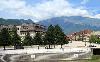
| Bajram Curri (town)
FeatureType : adm1st
Elevation : 358
Lat/Lng : 42.3581 / 20.0758
| Bajram Curri is a town situated in northern of Albania, near the border with Kosovo, in a remote, mostly mountainous region. The town is named after Bajram Curri, a national hero who fought for ethnic Albanians, first against the Ottoman Empire and later against the Albanian government (...) |
| 3 | | Valbona (river)
FeatureType : null
Elevation : 322
Lat/Lng : 42.2533 / 20.0436
| The Valbona is a river in northern Albania. It is still relatively untouched. Its source is in the Prokletije, near the border with Montenegro. The Valbonë flows generally east through the municipality Margegaj (mountain villages Valbonë, Dragobi and Shoshan), then turns south along Bajram Curri, (...) |
| 4 | 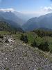
| Prokletije
FeatureType : mountain
Elevation : 2645
Lat/Lng : 42.4417 / 19.8125
| Prokletije (; ; both translated as "cursed mountains"), also known as the Albanian Alps (Alpet Shqiptare) and the Accursed Mountains, is a mountain range on the western Balkan peninsula, extending from northern Albania to Kosovo and eastern Montenegro (...) |
| 5 | | Valbonë Valley National Park
FeatureType : null
Elevation : 1396
Lat/Lng : 42.4413 / 19.9357
| The Valbona Valley National Park is a national park inside the Albanian Alps in northern Albania. The park covers a total area of , encompassing Valbona River and its surrounding areas with mountainous terrain, alpine landscapes, glacial springs, deep depressions, various rock formations, waterfalls (...) |
| 6 | | Valbona Pass
FeatureType : null
Elevation : 1802
Lat/Lng : 42.4056 / 19.8158
| The Valbona Pass is a high mountain pass within the Albanian Alps in northern Albania. The current record for crossing from Theth to Valbona is held by Robert Meechan, of Hexham, and Brendan Thomson, of Skye, at a time of 3 hours 14 minutes. (...) |
| 7 | | Allande
FeatureType : null
Elevation : 580
Lat/Lng : 43.2667 / -6.6167
| Allande (Asturian and Galician-Asturian: Ayande) is a municipality in the Autonomous Community of the Principality of Asturias, Spain. Its capital is Pola de Allande. The municipality is bordered on the north by Villayón, on the south by Cangas del Narcea and Ibias, to the east by Tineo and to the (...) |
| 8 | | Valbona
FeatureType : null
Elevation : 953
Lat/Lng : 40.2288 / -0.8108
| Valbona can refer to: * The town of Valbona, Spain * Valbonë, a town in northern Albania * Valbonë (river) in Albania |
| 9 | | Gúdar-Javalambre
FeatureType : null
Elevation : 1056
Lat/Lng : 40.2531 / -0.7525
| Aramón Javalambre Gúdar-Javalambre is a comarca in Aragon, Spain. The most important town is Mora de Rubielos. This comarca is located at the southern end of Aragon, bordering the Valencian Community. The area is mountainous with the summits of the Sistema Ibérico rising over towns with little or (...) |
| 10 | | Kukës County
FeatureType : adm1st
Elevation : 511
Lat/Lng : 42.112 / 20.4208
| Kukës County is a landlocked county in northeastern Albania, with the capital in Kukës. The county spans and had a total population of 84,035 people as of 2016. The county borders on the counties of Dibër, Lezhë and Shkodër and the countries of Kosovo and the Republic of Macedonia (...) |
| 11 | 
| Spanish Steps
FeatureType : landmark
Elevation : 32
Lat/Lng : 41.9058 / 12.4819
| The Spanish Steps are a set of steps in Rome, Italy, climbing a steep slope between the Piazza di Spagna at the base and Piazza Trinità dei Monti, dominated by the Trinità dei Monti church at the top. The monumental stairway of 174 steps (the slightly elevated drainage system is often mistaken for (...) |
| 12 | | Pola de Allande
FeatureType : null
Elevation : 556
Lat/Lng : 43.2731 / -6.6215
| Pola de Allande is a town and a parish in Allande, a municipality within the province and autonomous community of Asturias, in northern Spain. It is surrounded by the Cantabrian mountains. It is the capital of the parish. The town was founded between 1262 and 1268 (...) |
| 13 | | Lys (Dora Baltea)
FeatureType : waterbody
Elevation : 2358
Lat/Lng : 45.8833 / 7.8111
| The Lys (Walser German: Liisu or Lyesu) is a small river (classified as a torrente) which flows from the Lys Glacier on the south side of the Monte Rosa massif, at the foot of Vincent Pyramid, elevation , and runs through the Val de Gressoney, flanked by a road, before converging with the Dora (...) |
| 14 | | Lozzo Atestino
FeatureType : city
Elevation : 8
Lat/Lng : 45.2833 / 11.6333
| Lozzo Atestino is a comune (municipality) in the Province of Padua in the Italian region Veneto, located about southwest of Venice and about southwest of Padua, in the Colli Euganei regional park. The municipality of Lozzo Atestino contains the frazioni (subdivisions, mainly villages and hamlets) (...) |
| 15 | | Zla Kolata
FeatureType : mountain
Elevation : 2463
Lat/Lng : 42.485 / 19.8972
| Zla Kolata (Montenegrin: Зла Колата, Zla Kolata;) is a mountain of the Prokletije on the border of Montenegro and Albania. Summitpost claims incorrectly that this peak lies entirely within Montenegro. Retrieved 27 September 2011 (...) |
| 16 | | Valbonë
FeatureType : city
Elevation : 967
Lat/Lng : 42.4533 / 19.8878
| Valbonë is a village in the Kukës County, northern Albania. It is part of the former municipality Margegaj, and situated in the valley of the river Valbonë, south of the mountain Maja e Thatë. At the 2015 local government reform it became part of the municipality Tropojë (...) |
| 17 | | Margegaj
FeatureType : adm1st
Elevation : 1451
Lat/Lng : 42.4333 / 20.0667
| Margegaj is a village and a former municipality in the Kukës County, northern Albania. At the 2015 local government reform it became a subdivision of the municipality Tropojë. The population at the 2011 census was 2,346 (...) |
| 18 | | Maja e Thatë
FeatureType : mountain
Elevation : 2247
Lat/Lng : 42.4683 / 19.8689
| Maja e Thatë is a mountain peak of the Albanian Alps (Prokletije) in Albania.Military topographic map of Albania (1:25 000): K-34-52-D-a (M. JEZERCES) It is located within Valbonë Valley National Park, roughly northwest of Valbonë and rises more than above the village (...) |
| 19 | | Theth National Park
FeatureType : null
Elevation : 749
Lat/Lng : 42.3958 / 19.7744
| The Theth National Park is a national park in northern Albania. The park covers and is centred on the Albanian Alps, encompassing the larger portion of Shala Valley. The park was established to protect various ecosystems and biodiversity and the cultural and historical heritage of the region (...) |
| 20 | | Kosova National Art Gallery
FeatureType : landmark
Elevation : 604
Lat/Lng : 42.6571 / 21.164
| The Kosova National Art Gallery (KNAG;), is an art gallery situated at The University of Pristina Campus , right behind the National Library of Kosova in Prishtina, Kosovo, founded in February 1979. It is the highest institution of visual arts in the Republic of Kosova (...) |
 by
by