| 532 records found in wikipedia | |||
| 1 | 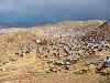
| Puno  FeatureType : city Elevation : 3832 Lat/Lng : -15.8434 / -70.0236 | Puno is a city in southeastern Peru, located on the shore of Lake Titicaca. It is the capital city of the Puno Region and the Puno Province with a population of approximately 149,064 (2014 estimate). The city was established in 1668 by viceroy Pedro Antonio Fernández de Castro as capital of the (...) |
| 2 | Puno Region FeatureType : adm1st Elevation : 4132 Lat/Lng : -15.07 / -70.12 | Puno is a region in southeastern Peru. It is bordered by Bolivia on the east, the Madre de Dios Region on the north, the Cusco and Arequipa regions on the west, the Moquegua Region on the southwest, and the Tacna Region on the south (...) | |
| 3 | Puno Province FeatureType : adm2nd Elevation : 3832 Lat/Lng : -15.8433 / -70.0236 | Puno is a province in the Puno Region, in southeastern Peru. It borders the provinces of Huancane, San Román, El Collao and the Moquegua Region's province of General Sánchez Cerro. Its capital is the city of Puno, which is located at the edge of Lake Titicaca, the world's highest navigable lake (...) | |
| 4 | 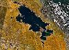
| Lake Titicaca FeatureType : waterbody Elevation : 3815 Lat/Lng : -15.8364 / -69.3386 | Lake Titicaca is a large, deep lake in the Andes on the border of Bolivia and Peru, often called the "highest navigable lake" in the world. By volume of water and by surface area, it is the largest lake in South America.Grove, M. J., P. A. Baker, S. L. Cross, C. A. Rigsby and G. O (...) |
| 5 | Puno District FeatureType : null Elevation : 3825 Lat/Lng : -15.8396 / -70.0215 | Puno District is one of fifteen districts of the Puno Province in the Puno Region of Peru. Its seat is Puno. (...) | |
| 6 | 
| Tacna FeatureType : city Elevation : 597 Lat/Lng : -18.0066 / -70.2462 | Tacna is a city in southern Peru and the regional capital of the Tacna Region. A very commercially active city, it is located only north of the border with Arica y Parinacota Region from Chile, inland from the Pacific Ocean and in the valley of the Caplina River (...) |
| 7 | 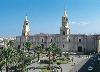
| Arequipa FeatureType : city Elevation : 2370 Lat/Lng : -16.4308 / -71.5155 | Arequipa is the capital and largest city of the Arequipa Region and the seat of the Constitutional Court of Peru. It is Peru's second most populous city with 861,145 inhabitants, as well as its second most populous metropolitan area as of 2016, according to the National Institute of Statistics and (...) |
| 8 | 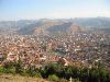
| Peru FeatureType : country Elevation : 152 Lat/Lng : -12.0433 / -77.0283 | Peru (; ; ;Quechua name used by government of Peru is Perú (see Quechua-language version of Peru Parliament and Quechua-language version of Peru Constitution), but common Quechua name is Piruw), officially the Republic of Peru (Es - República del Perú.ogg), is a country in western South America (...) |
| 9 | Azángaro Province FeatureType : adm2nd Elevation : 3867 Lat/Lng : -14.91 / -70.1975 | Azángaro Province is a province of the Puno Region in Peru. Instituto Nacional de Estadística e Informática. , Retrieved November 8, 2007 (...) | |
| 10 | Lampa, Peru FeatureType : city Elevation : 3873 Lat/Lng : -15.3636 / -70.3656 | Lampa is a town in Southern Peru. It is the capital of the Lampa Province in the Puno Region. Lampa is situated at the lake Pukaqucha. File:Lampa Puno.jpgThe town of Lampa and parts of the lake Pukaqucha as seen from the air (...) | |
| 11 | Carabaya Province FeatureType : adm2nd Elevation : 4323 Lat/Lng : -14.0695 / -70.4312 | Carabaya Province is a province of the Puno Region in the southern part of Peru. Instituto Nacional de Estadística e Informática. , Retrieved December 29, 2007 It is bounded on the north by the Madre de Dios Region, on the east by the Sandia Province, on the south by the provinces of Azángaro, (...) | |
| 12 | Sandia Province FeatureType : adm2nd Elevation : 3050 Lat/Lng : -14.2482 / -69.431 | Sandia Province is a province of the Puno Region in Peru. Instituto Nacional de Estadística e Informática. , Retrieved November 7, 2007 The capital of the province is the city of Sandia. (...) | |
| 13 | Juliaca FeatureType : null Elevation : 3834 Lat/Lng : -15.4937 / -70.1322 | Juliaca (Spanish: Juliaca, Quechua: Hullaqa, Aymara: Hullaqa) is the capital of San Roman Province in the Puno Region of southeastern Peru. It is the region's largest city with a population of 225,146 inhabitants (2007) (...) | |
| 14 | Desaguadero, Bolivia-Peru FeatureType : city Elevation : 3826 Lat/Lng : -16.5667 / -69.0333 | Desaguadero (Spanish for "channel, drain for drawing off superfluous water") or Chaka Marka (Aymara and Quechua for "bridge village") is a town on the Bolivian-Peruvian border. On the Bolivian side it is situated in the La Paz Department, Ingavi Province, Desaguadero Municipality, Desaguadero Canton (...) | |
| 15 | Carumas District FeatureType : null Elevation : 3046 Lat/Lng : -16.8093 / -70.6948 | Carumas District is one of six districts of the province Mariscal Nieto in Peru. Instituto Nacional de Estadística e Informática. . Retrieved April 11, 2008. (...) | |
| 16 | Lampa Province FeatureType : adm2nd Elevation : 4762 Lat/Lng : -15.4167 / -70.5833 | Lampa province is a province of the Puno region in Peru. Its population is about 50,000. The capital is Lampa. Municipalidad Provincial de Lampa, , Retrieved November 8, 2007. (...) | |
| 17 | El Collao Province FeatureType : adm2nd Elevation : 3863 Lat/Lng : -16.0853 / -69.637 | El Collao Province is a province of the Puno Region in Peru, Instituto Nacional de Estadística e Informática. , Retrieved December 29, 2007 created in 1992. The capital of the province is the city of Ilave. (...) | |
| 18 | Melgar Province FeatureType : adm2nd Elevation : 3918 Lat/Lng : -14.8818 / -70.5901 | Melgar Province is a province of the Puno Region in Peru. Instituto Nacional de Estadística e Informática. , Retrieved January 2, 2008 The capital of the province is the city of Ayaviri. (...) | |
| 19 | General Sánchez Cerro Province FeatureType : adm2nd Elevation : 2181 Lat/Lng : -16.6742 / -70.9703 | The General Sánchez Cerro Province is the smallest of three provinces in the Moquegua Region of Peru. The capital of the province is Omate. The province was named after the former Peruvian army officer and president Luis Miguel Sánchez Cerro. (...) | |
| 20 | 
| Mollendo FeatureType : city Elevation : 70 Lat/Lng : -17.0231 / -72.0147 | Mollendo is a town bordering the Pacific Ocean in southern Peru. It is located in the Arequipa Region and is the capital of both the Islay Province and the Mollendo District. Mollendo was the main port in the Peruvian southern coast until Matarani was developed about 50 years ago; the port of (...) |
| 21 | Arequipa Region FeatureType : adm1st Elevation : 2934 Lat/Lng : -15.86 / -72.25 | Arequipa is a region in southwestern Peru. It is bordered by the Ica, Ayacucho, Apurímac and Cusco regions in the north, the Puno Region in the east, the Moquegua Region in the south, and the Pacific Ocean in the west. Its capital, also called Arequipa, is Peru's second-largest city. (...) | |
| 22 | Huancané Province FeatureType : adm2nd Elevation : 3851 Lat/Lng : -15.2022 / -69.7614 | Huancané Province (from Aymara Wanqani listen, meaning "the one with big stones") is a province of the Puno Region in Peru. Instituto Nacional de Estadística e Informática. , Retrieved January 2, 2008 The capital of the province is the city of Huancané. (...) | |
| 23 | Chucuito Province FeatureType : adm2nd Elevation : 3895 Lat/Lng : -16.2144 / -69.4574 | Chucuito Province is a province of the Puno Region in Peru. Instituto Nacional de Estadística e Informática. , Retrieved December 29, 2007 The capital of the province is the city of Juli. (...) | |
| 24 | San Antonio de Putina Province FeatureType : adm2nd Elevation : 3862 Lat/Lng : -14.9139 / -69.8736 | San Antonio de Putina Province is a province of the Puno Region in Peru. Instituto Nacional de Estadística e Informática. , Retrieved January 2, 2008 (...) | |
| 25 | Arequipa Province FeatureType : adm2nd Elevation : 2348 Lat/Lng : -16.3988 / -71.5369 | Arequipa is a province in the Arequipa Region, Peru. Its capital, Arequipa, is Peru's third most populous province of Peru. It borders the provinces of Islay, Camaná, Caylloma, and the Cusco and Puno regions. According to INEI in the year 2014 it has a population of 958.351 people. (...) | |
| 26 | San Antonio District, Puno FeatureType : null Elevation : 4617 Lat/Lng : -16.0986 / -70.5583 | San Antonio District or San Antonio de Esquilache District is one of fifteen districts of the Puno Province in the Puno Region of Peru. Instituto Nacional de Estadística e Informática. . Retrieved April 11, 2008. (...) | |
| 27 | Glorioso Colegio Nacional de San Carlos FeatureType : null Elevation : 3843 Lat/Lng : -15.8376 / -70.0274 | Glorious National School of Saint Charles was created by decree of Simón Bolivar on 7 August 1825 in Puno, Peru. The school situated in the urban radius of the city of Puno and pertaining to the Unit of Local Educational Management Puno (UGEL Puno), according to the Resolution Directoral Number (...) | |
| 28 | Pichacani District FeatureType : null Elevation : 4001 Lat/Lng : -16.1477 / -70.0674 | Pichacani (hispanicized spelling) or Pichaqani (Aymara pichaqa a big needle, see: Piqacha, pichaqa and Phichaqa -ni a suffix, "the one with a big needle") is one of fifteen districts of the Puno Province in the Puno Region in Peru. Instituto Nacional de Estadística e Informática. (...) | |
| 29 | Estadio E. Torres Belón FeatureType : landmark Elevation : 3823 Lat/Lng : -15.8369 / -70.022 | Estadio Enrique Torres Belón is a multi-purpose stadium in Puno, Peru. It is currently used by football team Alfonso Ugarte. The stadium is built out of stone and has a capacity of 20,000 people. It is named after Senator Enrique Torres Belón from the Puno Region (...) | |
| 30 | San Román Province FeatureType : adm2nd Elevation : 3833 Lat/Lng : -15.4909 / -70.1331 | San Román is a province in the Puno Region of Peru. It borders the provinces of Lampa, Azángaro, Puno, Huancane, the Arequipa Province of the Arequipa Region and Moquegua Region's province of General Sánchez Cerro. Its capital is the city of Juliaca which is also second-largest city of the region. (...) | |
| 31 | Candarave Province FeatureType : adm2nd Elevation : 3434 Lat/Lng : -17.2701 / -70.2516 | Candarave Province is the smallest of four provinces in the Tacna Region in southern Peru. Its capital is Candarave. (...) | |
| 32 | Tarata Province FeatureType : null Elevation : 3090 Lat/Lng : -17.4742 / -70.0314 | Tarata is one of four provinces in the Tacna Region in southern Peru. Its capital is Tarata city. (...) | |
| 33 | Yunguyo Province FeatureType : adm2nd Elevation : 3845 Lat/Lng : -16.2442 / -69.0928 | Yunguyo Province is a province of the Puno Region in Peru. Instituto Nacional de Estadística e Informática. , Retrieved January 2, 2008 The capital of the province is the city of Yunguyo. (...) | |
| 34 | Sandia, Peru FeatureType : city Elevation : 2907 Lat/Lng : -14.2333 / -69.4333 | Sandia is a town in Southern Peru, capital of the province Sandia in the region Puno. (...) | |
| 35 | Moquegua Region FeatureType : adm1st Elevation : 3302 Lat/Lng : -16.8 / -70.8 | Moquegua is a department in southern Peru that extends from the coast to the highlands. Its capital is the city of Moquegua, its beautiful historical center is grandiose monument of the creativity of its people, the highest expression of architecture is reflected in the traditional slanted roofs, (...) | |
| 36 | Cordillera Apolobamba FeatureType : mountain Elevation : 3323 Lat/Lng : -14.4658 / -69.09 | Apolobamba (Cordillera (de) Apolobamba) is a mountain range in the South American Andes. (...) | |
| 37 | Cusco Region FeatureType : adm1st Elevation : 3902 Lat/Lng : -13.26 / -72.11 | Cusco, also spelled Cuzco , is a region in Peru. It is bordered by the Ucayali Region on the north; the Madre de Dios and Puno regions on the east; the Arequipa Region on the south; and the Apurímac, Ayacucho and Junín regions on the west. Its capital is Cusco, the capital of the Inca Empire. (...) | |
| 38 | Santa Rosa District, El Collao FeatureType : null Elevation : 3983 Lat/Lng : -16.7421 / -69.7233 | Santa Rosa District is one of five districts of the province El Collao in Puno Region, Peru. Instituto Nacional de Estadística e Informática. . Retrieved April 11, 2008. (...) | |
| 39 | Esteves (island) FeatureType : null Elevation : 3815 Lat/Lng : -15.8272 / -70.01 | Esteves (Spanish: Isla Esteves) is an island in the Peruvian part of Lake Titicaca near the city of Puno in Puno Province, Puno Department. The Island has only one road, Sesquicentenario, but has a dirt road that encircles the island, as well as two helicopter landings (...) | |
| 40 | Cordillera Vilcanota FeatureType : mountain Elevation : 4641 Lat/Lng : -13.7667 / -71.3 | The Cordillera Vilcanota (Spanish cordillera: "mountain range", Aymara Willkan Uta or Willkanuta: "house of the sun") is a mountain range located in Peru southeast of Cusco, on the boundary between the regions of Cusco and Puno (...) | |
| 41 | Eliodoro Camacho Province FeatureType : adm2nd Elevation : 4175 Lat/Lng : -15.5 / -69.0833 | Eliodoro Camacho is a province in the La Paz Department in Bolivia situated at Lake Titicaca. Its seat is Puerto Acosta. Camacho Province is situated in the western region of the La Paz Department bordered to the north by the Muñecas Province, to the east by the Larecaja Province, to the south by (...) | |
| 42 | Department of Tacna FeatureType : adm1st Elevation : 3356 Lat/Lng : -17.6 / -70.2 | Tacna is the southernmost department in Peru. Present-day Tacna Department was occupied by the Chilean Army during the War of the Pacific from 1885 to 1929, when it was reincorporated into Peruvian soil; today, it is known for being one of the most patriotic areas in the country. (...) | |
| 43 | Guaqui FeatureType : null Elevation : 3832 Lat/Lng : -16.5991 / -68.8501 | Guaqui is a railhead and port in Bolivia on Lake Titicaca. A ferry (a car float) connects with the Peruvian railhead and port on Puno. (...) | |
| 44 | Inambari River FeatureType : null Elevation : 198 Lat/Lng : -12.7167 / -69.7333 | The Inambari River in southeastern Peru flows from the Cordillera Apolobamba in the Andes to the Madre de Dios River. The river spans the Puno and Madre de Dios regions. Tributaries include the rivers Yanaqucha, Pukaramayu, Mancuari, Wila Uma, Blanco, San Bartolome, Yawarmayu and Winchusmayu (...) | |
| 45 | Moho Province FeatureType : adm2nd Elevation : 3891 Lat/Lng : -15.3608 / -69.4998 | Moho Province is a province of the Puno Region in Peru. Instituto Nacional de Estadística e Informática. , Retrieved January 2, 2008 (...) | |
| 46 | Supreme Court of the Philippines FeatureType : landmark Elevation : 11 Lat/Lng : 14.5798 / 120.9844 | The Supreme Court of the Philippines (; colloquially referred to as Korte Suprema) is the highest court in the Philippines. It is presided over by a Chief Justice and is composed of fifteen (15) Justices, including the Chief Justice (...) | |
| 47 | Viceroyalty of Peru FeatureType : null Elevation : 152 Lat/Lng : -12.0433 / -77.0283 | The Viceroyalty of Peru was a Spanish imperial provincial administrative district, created in 1542, that originally contained most of Spanish-ruled South America, governed from the capital of Lima. The Viceroyalty of Peru was one of the two Spanish Viceroyalties in the Americas from the sixteenth to (...) | |
| 48 | Wankarani (Puno) FeatureType : mountain Elevation : 5177 Lat/Lng : -16.1083 / -70.2567 | Wankarani (Aymara wankanra a kind of drum, -ni a suffix to indicate ownership, "the one with a wankara", Hispanicized spelling Huancarani) is a mountain in the Andes of southern Peru. It is situated in the Puno Region, Puno Province, on the border of the districts Pichacani and San Antonio.escale (...) | |
| 49 | Acora District FeatureType : null Elevation : 3935 Lat/Lng : -15.9751 / -69.8041 | Acora District is one of fifteen districts of the Puno Province in the Puno Region, Peru. Portal de la Municipalidad Distrital de Acora. . Retrieved March 19, 2008. Instituto Nacional de Estadística e Informática. . Retrieved March 19, 2008. (...) | |
| 50 | Titicaca National Reserve FeatureType : landmark Elevation : 3815 Lat/Lng : -15.8364 / -69.3386 | The Titicaca National Reservation is located in the Puno Region, Peru, in the Puno and Huancané provinces. Its main purpose is to preserve the ecosystems and landscapes of the Titicaca lake and surrounding Central Andean wet puna ecoregion. (...) | |
| 51 | Chucuito FeatureType : river Elevation : 3889 Lat/Lng : -15.8947 / -69.8922 | Chucuito is a village in the Chucuito District, Puno Province, Peru. It is from the city of Puno. It sits at above sea level. The population is 7,913.2007 Census (...) | |
| 52 | Andes FeatureType : mountain Elevation : 6868 Lat/Lng : -32.6533 / -70.0117 | The Andes or Andean Mountains are the longest continental mountain range in the world, forming a continuous highland along the western edge of South America. This range is about long, about wide (widest between 18° south and 20° south latitude), and of an average height of about (...) | |
| 53 | Vilque District FeatureType : null Elevation : 3873 Lat/Lng : -15.7662 / -70.2611 | Vilque District is one of fifteen districts of the province Puno in Peru. Instituto Nacional de Estadística e Informática. . Retrieved April 11, 2008. Vilque was the location of the major fair during the nineteenth century of goods from Bolivia and Argentina and especially for mules from Salta (...) | |
| 54 | Macusani District FeatureType : city Elevation : 4319 Lat/Lng : -14.0686 / -70.4314 | Macusani District is one of ten districts of the Carabaya Province in Peru. Instituto Nacional de Estadística e Informática. . Retrieved April 11, 2008. Its seat is Macusani. (...) | |
| 55 | Nuñoa District FeatureType : null Elevation : 4038 Lat/Lng : -14.48 / -70.6411 | Nuñoa District is one of nine districts of the Melgar Province in Peru. Instituto Nacional de Estadística e Informática. . Retrieved April 11, 2008. (...) | |
| 56 | Corani District FeatureType : city Elevation : 4234 Lat/Lng : -13.8753 / -70.6081 | Corani (from Aymara Qurani, meaning "the one with herbs") is one of ten districts of the Carabaya Province in Peru. Instituto Nacional de Estadística e Informática. . Retrieved April 11, 2008. (...) | |
| 57 | Urubamba River FeatureType : river Elevation : 207 Lat/Lng : -10.7008 / -73.756 | The Urubamba River or Vilcamayo River (possibly from Quechua Willkamayu, for "sacred river") is a river in Peru. Upstream it is called Vilcanota River (possibly from Aymara Willkanuta, for "house of the sun"). Within the La Convención Province the naming changes to Urubamba (...) | |
| 58 | Amazonas Region FeatureType : null Elevation : 2145 Lat/Lng : -6.22 / -77.85 | Amazonas is a region of northern Peru bordered by Ecuador on the north and west, Cajamarca Region on the west, La Libertad Region on the south, and Loreto Region and San Martín Region on the east. Its capital is the city of Chachapoyas (...) | |
| 59 | University of the Philippines FeatureType : landmark Elevation : 62 Lat/Lng : 14.6549 / 121.0645 | The University of the Philippines (UP; Filipino: Unibersidad ng Pilipinas or Pamantasan ng Pilipinas) is a state university system in the Philippines, and is the country's national university. Founded by the American colonial government on June 18, 1908, it was originally a university conceived for (...) | |
| 60 | Madre de Dios Region FeatureType : adm1st Elevation : 366 Lat/Lng : -11.99 / -70.59 | Madre de Dios is a region in southeastern Peru, bordering Brazil, Bolivia and the Peruvian regions of Puno, Cusco and Ucayali, in the Amazon Basin. Its capital is the city of Puerto Maldonado. The name of the region is derived from the Madre de Dios River, ultimately a tributary of the Amazon, and (...) | |
| 61 | Suches Lake FeatureType : waterbody Elevation : 4602 Lat/Lng : -14.7681 / -69.2719 | Laguna Suches or Lago Suches is a lake in the La Paz Department of Bolivia and Puno Region, Peru. Located at an elevation of 4605 m, its surface area is 14.2 km². (...) | |
| 62 | Macusani FeatureType : city Elevation : 4323 Lat/Lng : -14.0692 / -70.4311 | Macusani is a town in Southern Peru, capital of the province Carabaya in the region Puno. (...) | |
| 63 | Ilave FeatureType : city Elevation : 3859 Lat/Lng : -16.0866 / -69.6354 | Ilave, also known as Illawi, is the capital city of the Ilave District in El Collao Province, in the Puno Region of Peru. According to the projection of the 2012 census, it has 57,366 inhabitants. (...) | |
| 64 | Uru people FeatureType : null Lat/Lng : -15.8197 / 69.9703 | The Uru or Uros are an indigenous people of Peru and Bolivia. They live on an approximate and still growing 120 self-fashioned floating islands in Lake Titicaca near Puno. They form three main groups: the Uru-Chipaya, Uru-Murato, and Uru-Iruito (...) | |
| 65 | Qutuni (Puno) FeatureType : mountain Elevation : 5141 Lat/Lng : -16.0792 / -70.2903 | Qutuni (Aymara qutu heap, pile, -ni a suffix to indicate ownership, "the one with a heap", Hispanicized spelling Cutune) is a mountain in the Andes of southern Peru, about high. It is situated in the Puno Region, Puno Province, San Antonio District. Qutuni lies northwest of the mountain Wankarani (...) | |
| 66 | Zepita District FeatureType : null Elevation : 3831 Lat/Lng : -16.4988 / -69.1101 | Zepita (from Aymara Sipita) is one of seven districts of the Chucuito Province in Puno Region, Peru. Instituto Nacional de Estadística e Informática. . Retrieved April 11, 2008. (...) | |
| 67 | Pomata District FeatureType : null Elevation : 3859 Lat/Lng : -16.2667 / -69.3088 | Pomata District is one of seven districts of the Chucuito Province in Puno Region, Peru. Instituto Nacional de Estadística e Informática. . Retrieved April 11, 2008. (...) | |
| 68 | Yanawara (Puno) FeatureType : mountain Elevation : 5215 Lat/Lng : -15.3683 / -70.6794 | Yanawara (Quechua yana black, wara trousersTeofilo Laime Ajacopa, Diccionario Bilingüe Iskay simipi yuyayk'ancha, La Paz, 2007 (Quechua-Spanish dictionary) "black trousers", hispanicized spelling Yanahuara) or Mina Punta (also Minapunta) is a mountain in the Andes of Peru, about high (...) | |
| 69 | Huata District, Puno FeatureType : null Elevation : 3822 Lat/Lng : -15.6226 / -70.0538 | Huata District is one of fifteen districts of the province Puno in Peru. Instituto Nacional de Estadística e Informática. . Retrieved April 11, 2008. (...) | |
| 70 | Chucuito District FeatureType : null Elevation : 3952 Lat/Lng : -15.9013 / -69.897 | Chucuito District is one of the districts of the Puno Province in the Puno Region in Peru. Municipalidad Distrital Chucuito, , Retrieved November 9, 2007. (...) | |
| 71 | Tiquillaca District FeatureType : null Elevation : 3878 Lat/Lng : -15.7974 / -70.1895 | Tiquillaca District is one of fifteen districts of the province Puno in Peru. Instituto Nacional de Estadística e Informática. . Retrieved April 11, 2008. (...) | |
| 72 | Coata District FeatureType : null Elevation : 3820 Lat/Lng : -15.5773 / -70.0267 | Coata District is one of fifteen districts of the province Puno in Peru. Instituto Nacional de Estadística e Informática. . Retrieved April 11, 2008. (...) | |
| 73 | Ilave District FeatureType : adm3rd Elevation : 3838 Lat/Lng : -16.1028 / -69.6061 | Ilave District is one of five districts of the province El Collao in Puno Region, Peru. Instituto Nacional de Estadística e Informática. . Retrieved April 11, 2008. (...) | |
| 74 | Capachica District FeatureType : null Elevation : 3820 Lat/Lng : -15.6394 / -69.9768 | Capachica District is one of fifteen districts of the province Puno in Peru. Instituto Nacional de Estadística e Informática. . Retrieved April 11, 2008. Its seat is Capachica. (...) | |
| 75 | Yunguyo FeatureType : city Elevation : 3845 Lat/Lng : -16.2442 / -69.0928 | Yunguyo is a town in the Puno Region in southeastern Peru. It is the capital of Yunguyo Province and Yunguyo District. It has a population of 12,625 (2008 estimate). Yunguyo is located on a peninsula on the shores of Lake Titicaca (...) | |
| 76 | Paucarcolla District FeatureType : null Elevation : 3864 Lat/Lng : -15.7462 / -70.0585 | Paucarcolla District is one of fifteen districts of the province Puno in Peru. Instituto Nacional de Estadística e Informática. . Retrieved April 11, 2008. (...) | |
| 77 | Mañazo District FeatureType : null Elevation : 3939 Lat/Lng : -15.801 / -70.348 | Mañazo (Aymara Mañasu, meaning butcher) is one of fifteen districts of the province Puno in Peru. Instituto Nacional de Estadística e Informática. . Retrieved April 11, 2008. (...) | |
| 78 | Plateria District FeatureType : null Elevation : 3826 Lat/Lng : -15.9494 / -69.8371 | Platería District is one of fifteen districts of the province Puno in Peru. Instituto Nacional de Estadística e Informática. . Retrieved April 11, 2008. (...) | |
| 79 | Canas Province FeatureType : adm2nd Elevation : 3912 Lat/Lng : -14.2181 / -71.4317 | Canas Province is one of thirteen provinces in the Cusco Region in the southern highlands of Peru. (...) | |
| 80 | Inka Tunuwiri FeatureType : null Elevation : 3819 Lat/Lng : -15.87 / -69.93 | Inka Tunuwiri (Hispanicized spelling Incatunuhuiri) is an archaeological site in Peru. It is located in the Puno Region, Puno Province, between the districts Chucuito and Puno,escale.minedu.gob.pe - UGEL map of the Puno Province zone 1 (Puno Region) southeast of the village Ichu (...) | |
| 81 | Chupaca Province FeatureType : adm2nd Elevation : 3272 Lat/Lng : -12.06 / -75.29 | Chupaca Province, located in Central Peru, is one of the nine provinces that compose the Junín Region, bordering to the north with the Concepción Province, to the east with the Huancayo Province, to the south with the Huancavelica Region and to the west with the Lima Region (...) | |
| 82 | Quispicanchi Province FeatureType : adm2nd Elevation : 3436 Lat/Lng : -13.7 / -71.64 | Quispicanchi Province is one of thirteen provinces in the Cusco Region in the southern highlands of Peru. (...) | |
| 83 | Azángaro FeatureType : city Elevation : 3867 Lat/Lng : -14.9099 / -70.1974 | Azángaro is a town in Southern Peru, capital of the province Azángaro in the region of Puno. Instituto Nacional de Estadística e Informática. , Retrieved January 6, 2008 The colonial church in Azangaro is known as the golden temple (...) | |
| 84 | Ponteareas FeatureType : null Elevation : 53 Lat/Lng : 42.1753 / -8.505 | Ponteareas is town and municipality in the province of Pontevedra, in Spain It is located on the Vigo-Benavente highway and on the river Tea, a right-hand tributary of the Miño. It is the chief town of a fertile hilly region, which produces wine, grain and fruit, and contains many cattle farms (...) | |
| 85 | Roman Catholic Archdiocese of Arequipa FeatureType : null Elevation : 2364 Lat/Lng : -16.3833 / -71.5333 | The Roman Catholic Archdiocese of Arequipa is an archdiocese located in the city of Arequipa in Peru. Catholic-Hierarchy.org. David M. Cheney. Retrieved February 29, 2016 GCatholic.org. Gabriel Chow. Retrieved February 29, 2016 It was erected by Pope Gregory XIII on 15 April 1577 at the request of (...) | |
| 86 | Putina (town) FeatureType : city Elevation : 3862 Lat/Lng : -14.9139 / -69.8736 | Putina is a town in southern Peru, capital of the province San Antonio de Putina in the region Puno. In Quechua, the word "Putina" means boiling water. It was found in May, 24, 1595. (...) | |
| 87 | Desaguadero District FeatureType : null Elevation : 3873 Lat/Lng : -16.5648 / -69.0472 | Desaguadero District is one of seven districts of the province Chucuito in Puno Region, Peru. Instituto Nacional de Estadística e Informática. . Retrieved April 11, 2008. (...) | |
| 88 | Lake Arapa FeatureType : waterbody Elevation : 3812 Lat/Lng : -15.1831 / -69.9694 | Lake Arapa is a peruvian lake situated in the Arapa and Chupa Districts in the Azángaro Province of the Puno Region. It is located 40 km from Juliaca. (...) | |
| 89 | Moho, Peru FeatureType : city Elevation : 3891 Lat/Lng : -15.3608 / -69.4998 | Moho (aymara: Muju) is a town in Southern Peru, capital of the province Moho in the region Puno. Instituto Nacional de Estadística e Informática. , Retrieved June 3, 2008 (...) | |
| 90 | Wila Salla FeatureType : mountain Elevation : 4981 Lat/Lng : -16.1708 / -70.3017 | Wila Salla (Aymara wila salla rocks, cliffs, "red rocks", Hispanicized spelling Velasalla) is a mountain in the Andes of southern Peru. It is located in the Puno Region, Puno Province, on the border of the districts Pichacani and San Antonio. Wila Salla lies northeast of the mountain Chuqipata (...) | |
| 91 | San Antonio (disambiguation) FeatureType : null Elevation : 520 Lat/Lng : -26.0593 / -53.732 | San Antonio is the seventh-most populous city in the United States and the second-most populous in the state of Texas. San Antonio may also refer to: (...) | |
| 92 | Mactan–Cebu International Airport FeatureType : null Elevation : 7 Lat/Lng : 10.3075 / 123.9794 | Mactan–Cebu International Airport located in Central Visayas region, is the second busiest international airport in the Philippines. It is located in Lapu-Lapu City on Mactan Island, a part of Metro Cebu. The airport is managed by the Mactan–Cebu International Airport Authority (...) | |
| 93 | San Miguel, Bulacan FeatureType : null Elevation : 22 Lat/Lng : 15.1361 / 120.9761 | , officially the , , is a settlement_text of the Philippines in the province of , . According to the , it has a population of people. It is the third largest municipality by area in the province after Doña Remedios Trinidad and Norzagaray. (...) | |
| 94 | Ollachea District FeatureType : city Elevation : 2704 Lat/Lng : -13.7947 / -70.4714 | Ollachea District is one of ten districts of the province Carabaya in Peru. Instituto Nacional de Estadística e Informática. . Retrieved April 11, 2008. (...) | |
| 95 | Santa Rosa District, Melgar FeatureType : null Elevation : 4379 Lat/Lng : -14.6114 / -70.9311 | Santa Rosa District is one of nine districts of the province Melgar in Peru. Instituto Nacional de Estadística e Informática. . Retrieved April 11, 2008. (...) | |
| 96 | San Antón District FeatureType : null Elevation : 3956 Lat/Lng : -14.5881 / -70.3108 | San Anton District is one of fifteen districts of the Azángaro Province in Peru. Instituto Nacional de Estadística e Informática. . Retrieved April 11, 2008. (...) | |
| 97 | Sina District FeatureType : null Elevation : 4713 Lat/Lng : -14.5013 / -69.5749 | Sina District is one of five districts of the San Antonio de Putina Province in the Puno Region of Peru. Instituto Nacional de Estadística e Informática. . Retrieved April 11, 2008. (...) | |
| 98 | Huacullani District FeatureType : null Elevation : 4298 Lat/Lng : -16.6305 / -69.6002 | Huacullani (from Aymara Waqullani) is one of seven districts of the Chucuito Province in the Puno Region in southern Peru. Instituto Nacional de Estadística e Informática. . Retrieved April 11, 2008. (...) | |
| 99 | Ananta (Puno) FeatureType : mountain Elevation : 5270 Lat/Lng : -13.8139 / -70.6206 | Ananta is a mountain in the Vilcanota mountain range in the Andes of Peru, about high. It is situated in the Puno Region, Carabaya Province, Corani District. Ananta lies south of the mountain Macho Ritti, west of the lake Mancacocha and north of the lake Puytococha. (...) | |
| 100 | Capaso District FeatureType : null Elevation : 4401 Lat/Lng : -17.1837 / -69.7445 | Capazo District is one of five districts of the province El Collao in Puno Region, Peru. Instituto Nacional de Estadística e Informática. . Retrieved April 11, 2008. (...) | |
| 101 | Cuyocuyo District FeatureType : null Elevation : 4428 Lat/Lng : -14.4829 / -69.8302 | Cuyocuyo District is one of ten districts of the province Sandia in Peru. Instituto Nacional de Estadística e Informática. . Retrieved April 11, 2008. (...) | |
| 102 | Pucará District, Lampa FeatureType : null Elevation : 4222 Lat/Lng : -15.0489 / -70.3786 | Pucará District is one of ten districts of the province Lampa in Peru. Instituto Nacional de Estadística e Informática. . Retrieved April 11, 2008. (...) | |
| 103 | Ituata District FeatureType : city Elevation : 3647 Lat/Lng : -13.7911 / -70.2514 | Ituata District is one of ten districts of the Carabaya Province in Peru. Instituto Nacional de Estadística e Informática. . Retrieved April 11, 2008. (...) | |
| 104 | Zepita FeatureType : city Elevation : 3832 Lat/Lng : -16.5 / -69.1 | Zepita is a town in the Chucuito Province south of Lake Titicaca in the Puno Region, Peru. | |
| 105 | Kuntur Ikiña (Puno) FeatureType : mountain Elevation : 4802 Lat/Lng : -15.8742 / -70.3153 | Kuntur Ikiña (Aymara kunturi condor,Yatiqirinaka Aru Pirwa, Lima, 2005 (Aymara-Spanish dictionary) ikiña to sleep, bed or blanket, hispanicized spelling Condoriquiña) is a mountain in the Andes of Peru, about high (...) | |
| 106 | Battle of Ayacucho FeatureType : event Elevation : 3385 Lat/Lng : -13.0425 / -74.1317 | The Battle of Ayacucho was a decisive military encounter during the Peruvian War of Independence. It was the battle that secured the independence of Peru and ensured independence for the rest of South America. In Peru it is considered the end of the Spanish American wars of independence, although (...) | |
| 107 | Ticonata Island FeatureType : null Elevation : 3856 Lat/Lng : -15.6485 / -69.7877 | Ticonata or Tikonata (possibly from Aymara tikuna a kind of worm or caterpillar, -ta a suffix, "from") Félix Layme Pairumani, Diccionario de Sinónimos de lengua aymara: tikuna - Gusano blanco de la tierra.Juan Carvajal Carvaja et al, Diccionario Ilustrado Aymara, Español, Inglés: tikuna - gusano del (...) | |
| 108 | Amantaní District FeatureType : null Elevation : 4054 Lat/Lng : -15.6642 / -69.71 | Amantani Municipalidad distrital de Amantani (official website) is one of fifteen districts of the Puno Province in the Puno region, Peru. Instituto Nacional de Estadística e Informática. '. Retrieved March 19, 2008. (...) | |
| 109 | Pukara, Puno FeatureType : null Elevation : 3912 Lat/Lng : -15.0453 / -70.3728 | Pukara, Puno (Aymara and Quechua for fortress, Hispanicized spellings Pucara, Pucará, also Pukará) is a town in the Puno Region, Lampa Province, Pucará District, Peru. It is located to the north-west of Lake Titicaca (...) | |
| 110 | Anapia District FeatureType : null Elevation : 3838 Lat/Lng : -16.2919 / -68.872 | Anapia District is one of seven districts of the province Yunguyo in Puno Region, Peru. Instituto Nacional de Estadística e Informática. . Retrieved April 11, 2008. (...) | |
| 111 | Ayaviri District, Melgar FeatureType : null Elevation : 3918 Lat/Lng : -14.8819 / -70.59 | Ayaviri or Ayawiri (Aymara) is one of nine districts of the province Melgar in Peru. Instituto Nacional de Estadística e Informática. . Retrieved April 11, 2008. (...) | |
| 112 | Yauyos District, Yauyos FeatureType : null Elevation : 2881 Lat/Lng : -12.4597 / -75.9187 | Yauyos District is one of thirty-three districts of the Yauyos Province in Peru. Instituto Nacional de Estadística e Informática. '. Retrieved April 11, 2008. (...) | |
| 113 | Ananea District FeatureType : null Elevation : 5042 Lat/Lng : -14.6325 / -69.4458 | Ananea District is one of five districts of the San Antonio de Putina Province in Peru. Instituto Nacional de Estadística e Informática. . Retrieved April 11, 2008. (...) | |
| 114 | Cordillera Carabaya FeatureType : mountain Elevation : 5614 Lat/Lng : -13.9089 / -70.409 | The Cordillera Carabaya (Spanish for "Carabaya mountain range")Teofilo Laime Ajacopa, Diccionario Bilingüe Iskay simipi yuyayk'ancha, La Paz, 2007 (Quechua-Spanish dictionary): kallawaya. - s. Provincia de Antisuyu. Los habitantes de dicha provincia eran y siguen siendo hábiles herbolarios (JL) (...) | |
| 115 | Alejandro Velasco Astete International Airport FeatureType : null Elevation : 3284 Lat/Lng : -13.5357 / -71.9388 | Alejandro Velasco Astete International Airport is an international airport located in the city of Cusco, in southeastern Peru. Cusco, a principal tourist attraction in Latin America, receives various domestic flights as well as some international flights. The runway is completely paved (...) | |
| 116 | Romanovka, Vsevolozhsky District, Leningrad Oblast FeatureType : null Lat/Lng : 60.0467 / 30.7023 | Romanovka (Finnish: Romanaisi) is a settlement and administrative center of the Romanovsky rural settlement of Vsevolozhsky District of Leningrad Oblast. (...) | |
| 117 | Languages of the Philippines FeatureType : null Elevation : 329 Lat/Lng : 9.6081 / 122.9155 | There are some 120 to 187 languages and dialects in the Philippines, depending on the method of classification.The Komisyon sa Wikang Filipino enumerated 134 Philippine languages and 1 national language (Filipino) present in the country through its Atlas Filipinas map published in 2016 (...) | |
| 118 | University of the Philippines Diliman FeatureType : null Elevation : 62 Lat/Lng : 14.6549 / 121.0645 | The University of the Philippines Diliman (also referred to as UPD, UP Diliman, or simply UP) is a coeducational, public research university located in Diliman, Quezon City, Philippines. It was established on February 12, 1949 as the flagship campus and seat of administration of the University of (...) | |
| 119 | Manila hostage crisis FeatureType : null Elevation : 11 Lat/Lng : 14.581 / 120.9749 | The Manila hostage crisis, officially known as the Rizal Park hostage-taking incident, took place when a disgruntled former Philippine National Police officer named Rolando Mendoza hijacked a tourist bus in Rizal Park, Manila, Philippines on August 23, 2010 (...) | |
| 120 | Train ferry FeatureType : landmark Elevation : 2 Lat/Lng : 55.3696 / 13.1589 | A train ferry is a ship (ferry) designed to carry railway vehicles. Typically, one level of the ship is fitted with railway tracks, and the vessel has a door at the front and/or rear to give access to the wharves (...) | |
| 121 | Peruvian Segunda División FeatureType : null Elevation : 3358 Lat/Lng : -13.525 / -71.9722 | The Segunda División Peruana (Second Division) of Peru is the second-highest division in the Peruvian football league system. It is a professional division and was declared a promotional division by the Peruvian Football Federation (FPF) (...) | |
| 122 | Kunturiri (Peru) FeatureType : mountain Elevation : 5061 Lat/Lng : -16.0944 / -70.2375 | Kunturiri (Aymara kunturi condor, -(i)ri a suffix, hispanicized spelling Condorire) is a mountain in the Andes of southern Peru, about high. It is situated in the Puno Region, Puno Province, Pichacani District. Kunturiri lies northeast of the mountain Wankarani and southeast of Ninachiri. (...) | |
| 123 | Vela Cunca (Puno) FeatureType : mountain Elevation : 5328 Lat/Lng : -13.8969 / -70.4464 | Vela Cunca (possibly from Aymara wila red, kunka throat, "red throat") is a mountain in the Carabaya mountain range in the Andes of Peru, about high. It is located in the Puno Region, Carabaya Province, on the border of the districts Macusani and Ollachea (...) | |
| 124 | Wiluyu (Tiquillaca) FeatureType : mountain Elevation : 4766 Lat/Lng : -16.0444 / -70.3842 | Wiluyu (Aymara wila blood, blood-red, uyu corral, "red corral", hispanicized spelling Veluyo) is a mountain in the Andes of southern Peru, about high. It is located in the Puno Region, Puno Province, Tiquillaca District (...) | |
| 125 | Ritipata (Puno) FeatureType : mountain Elevation : 5210 Lat/Lng : -14.6197 / -69.3594 | Ritipata (possibly from Quechua)Teofilo Laime Ajacopa, Diccionario Bilingüe Iskay simipi yuyayk'ancha, La Paz, 2007 (Quechua-Spanish dictionary) is a mountain in the Apolobamba mountain range in the Andes of Peru (...) | |
| 126 | Surichata FeatureType : mountain Elevation : 4930 Lat/Lng : -16.0436 / -70.2381 | Surichata (Aymara and Quechua suri rhea, Pukina chata mountain,Teofilo Laime Ajacopa, Lengua Pukina en Jesús de Machaca hispanicized spelling Zorrichata) is a mountain in the Andes of southern Peru, about high. It is situated in the Puno Region, Puno Province, on the border of the districts San (...) | |
| 127 | Tankani (Peru) FeatureType : mountain Elevation : 5209 Lat/Lng : -16.1928 / -70.3467 | Tankani (Aymara tanka hat and biretta of priests, -ni a suffix to indicate ownership, "the one with a hat (or biretta)", hispanicized spellings Tancane, Tangane) is a mountain in the Andes of southern Peru, about high (...) | |
| 128 | Wiluyu (Mañazo-Tiquillaca) FeatureType : mountain Elevation : 4788 Lat/Lng : -15.9192 / -70.3644 | Wiluyu (Aymara wila blood, blood-red, uyu corral, "red corral", hispanicized spelling Viluyo) is a mountain in the Andes of southern Peru, about high. It is located in the Puno Region, Puno Province, on the border of the districts Mañazo and Tiquillaca (...) | |
| 129 | Joyllor Puñuna FeatureType : mountain Elevation : 5623 Lat/Lng : -13.9281 / -70.8169 | Joyllor Puñuna is a mountain in the Vilcanota mountain range in the Andes of Peru, about 5,743 m (18,842 ft) high. It is situated on the border of the regions of Cusco and Puno.escale.minedu.gob.pe - UGEL map of Carabaya Province (Puno Region) Joyllor Puñuna is the highest elevation on the Quelccaya (...) | |
| 130 | PeruRail FeatureType : null Elevation : 4342 Lat/Lng : -14.4831 / -70.9889 | PeruRail is a railway operator providing tourist, freight, and charter services in southern Peru. It was founded in 1999 by Peruvian entrepreneur Lorenzo Sousa Debarbieri and British company Sea Containers. The main line between the port of Matarani, Arequipa (the capital of this region is Peru's (...) | |
| 131 | Palca District, Lampa FeatureType : null Elevation : 4715 Lat/Lng : -15.3222 / -70.605 | Palca District is one of ten districts of the province Lampa in Peru. Instituto Nacional de Estadística e Informática. . Retrieved April 11, 2008. (...) | |
| 132 | Sicuani District FeatureType : null Elevation : 3549 Lat/Lng : -14.27 / -71.2316 | Sicuani District is one of eight districts of the province Canchis in Peru. Instituto Nacional de Estadística e Informática. . Retrieved April 11, 2008. (...) | |
| 133 | Ocuviri District FeatureType : null Elevation : 4452 Lat/Lng : -15.121 / -71.2096 | Ocuviri District is one of ten districts of the province Lampa in Peru. Instituto Nacional de Estadística e Informática. . Retrieved April 11, 2008. (...) | |
| 134 | Paratia District FeatureType : null Elevation : 4602 Lat/Lng : -15.4581 / -70.6075 | Paratia District is one of ten districts of the province Lampa in Peru. Instituto Nacional de Estadística e Informática. . Retrieved April 11, 2008. (...) | |
| 135 | Ayapata District FeatureType : city Elevation : 3493 Lat/Lng : -13.7778 / -70.3225 | Ayapata District is one of ten districts of the province Carabaya in Peru. Instituto Nacional de Estadística e Informática. . Retrieved April 11, 2008. (...) | |
| 136 | Pukaqucha (Puno) FeatureType : waterbody Elevation : 3858 Lat/Lng : -15.3594 / -70.3506 | PukaquchaMunicipalidad Provincial de Lampa, Ampliación e Instalación del Sistemade Agua Potable y Alcantarillado en las Urbanizaciones Puente Colonial y Juan Velazco Alvarado del Distrito de Lampa, Provincia de Lampa – Puno, June 2013 (Quechua puka red, colored, qucha lake,Teofilo Laime Acopa, (...) | |
| 137 | Battle of Cotagaita FeatureType : event Elevation : 2644 Lat/Lng : -20.8177 / -65.6598 | The Battle of Cotagaita was fought on October 27, 1810 during the Campaign of Upper Peru in the Argentine War of Independence when the troops of the Army of the North were sent by the Primera Junta government in Buenos Aires to the Alto Perú to fight the Royalists (...) | |
| 138 | Ilo Province FeatureType : adm2nd Elevation : 68 Lat/Lng : -17.6333 / -71.3333 | The Ilo Province is one of three provinces that make up the Moquegua Region in Peru. The province is the largest mining center in all of the southern Peru area. (...) | |
| 139 | Rebellion of Túpac Amaru II FeatureType : null Elevation : 2868 Lat/Lng : -13.3082 / -72.1123 | The Rebellion of Túpac Amaru II (1780 – c. 1782) was an uprising of native and mestizo peasants against the Bourbon reforms in the Spanish Viceroyalty of Peru. While Túpac Amaru II, an early leader of the rebellion, was captured and executed in 1781, the rebellion continued for at least (...) | |
| 140 | Conduriri District FeatureType : null Elevation : 3961 Lat/Lng : -16.6156 / -69.7025 | Conduriri District is one of five districts of the El Collao Province in Puno Region, Peru. Instituto Nacional de Estadística e Informática. . Retrieved April 11, 2008. (...) | |
| 141 | Llusca Ritti (Cusco-Puno) FeatureType : mountain Elevation : 5222 Lat/Lng : -13.7253 / -70.7319 | Llusca Ritti (possibly from Quechua llusk'a polished; slippery, rit'i snow, "polished snow" or "slippery snow") or Ayachincana (possibly from Quechua aya corpse, chinkana labyrinth, "corpse labyrinth")John Ricker, Cordillera Vilcanota—1969, AAC (American Alpine Journal Publications is a mountain in (...) | |
| 142 | Surupana FeatureType : mountain Elevation : 5151 Lat/Lng : -14.6283 / -70.11 | Surupana (Aymara suru beak, pana a waterbird which lives at Lake Titicaca)Teodoro Marka M., Curso Basico de Lengua Aymara, Nociones Basicas de Lengua Aymara (see: Ave) is a mountain in the Peruvian Andes. It is situated in the Puno Region, Azángaro Province, San José District (...) | |
| 143 | Jonorana (Carabaya-Melgar) FeatureType : mountain Elevation : 5412 Lat/Lng : -14.0836 / -70.7697 | Jonorana (possibly from Aymara for a variety of potato of the qhini group) (see: Variedad de papa qhini) is a mountain in the Vilcanota mountain range in the Andes of Peru. It is situated in the Puno Region, Carabaya Province, Corani District, and in the Melgar Province, Nuñoa District (...) | |
| 144 | Central Philippine University FeatureType : edu Elevation : 10 Lat/Lng : 10.7303 / 122.5489 | Central Philippine University (also referred to as Central or CPU) is a private research university in Iloilo City, Philippines. Established in 1905 through a grant given by the American business magnate, industrialist and philanthropist John D (...) | |
| 145 | The X Factor Philippines (season 1) FeatureType : null Elevation : 10 Lat/Lng : 16.05 / 120.3333 | The X Factor Philippines is a Filipino television music competition to find a new singing talent. The first season began on June 23, 2012. KC Concepcion is the host of the show, while the judging panel consist of Charice, Gary Valenciano, Pilita Corrales, and Martin Nievera (...) | |
| 146 | Qillqa (Lampa) FeatureType : mountain Elevation : 5350 Lat/Lng : -15.3122 / -70.7331 | Qillqa (Quechua for writing (the act and art of writing),Teofilo Laime Ajacopa, Diccionario Bilingüe Iskay simipi yuyayk'ancha, La Paz, 2007 (Quechua-Spanish dictionary) hispanicized spelling Quilca) is a mountain in the Andes of Peru, about high (...) | |
| 147 | Atuncolla District FeatureType : adm3rd Elevation : 3836 Lat/Lng : -15.6881 / -70.1442 | Atuncolla District is one of fifteen districts of Puno Province in Peru. Instituto Nacional de Estadística e Informática. . Retrieved April 11, 2008. (...) | |
| 148 | Lake Umayo FeatureType : city Elevation : 3840 Lat/Lng : -15.7428 / -70.1897 | Lake Umayo (Spanish: Laguna Umayo) is a lake in Atuncolla District of the Puno Region of Peru. The Sillustani burial ground is near the shores of the lake. The lake is located at an elevation of and is about long and wide.Google Earth (...) | |
| 149 | Pomanota FeatureType : mountain Elevation : 5495 Lat/Lng : -14.0719 / -70.7981 | Pomanota (possibly from Aymara puma cougar, puma, -n(i) a suffix, uta house, "house of the puma") is a mountain in the Vilcanota mountain range in the Andes of Peru, about high. It is situated in the Cusco Region, Canchis Province, San Pablo District and in the Puno Region, Carabaya Province, Corani (...) | |
| 150 | Chullumpirini FeatureType : mountain Elevation : 5119 Lat/Lng : -14.0081 / -70.1828 | Chullumpirini (chullumpi local name for the white-tufted grebe) (pdf), p. 7 is a mountain in the Carabaya mountain range in the Andes of Peru, about high. It is located in the Puno Region, Carabaya Province, on the border of the districts Coasa and Ituata (...) | |
| 151 | Taruca Sayana FeatureType : mountain Elevation : 5222 Lat/Lng : -13.7475 / -70.6972 | Taruca Sayana (possibly from Quechua taruka, luychu deer, sayana stop, whereabouts, a place where you stop frequently, "deer stop") is a mountain in the Vilcanota mountain range in the Andes of Peru, about high (...) | |
| 152 | San José District, Azángaro FeatureType : null Elevation : 4034 Lat/Lng : -14.6872 / -70.1744 | San José District is one of fifteen districts of the Azángaro Province in Peru. Instituto Nacional de Estadística e Informática. . Retrieved April 11, 2008. (...) | |
| 153 | Jori Pintay FeatureType : mountain Elevation : 5211 Lat/Lng : -13.7314 / -70.7219 | Jori Pintay (possibly from Quechua quri gold, pintay to paint / painting (a borrowing from Spanish pintar to paint)) is a mountain in the Vilcanota mountain range in the Andes of Peru, about high. It is located in the Puno Region, Carabaya Province, in the districts Corani and Ollachea (...) | |
| 154 | Manuel Quimper FeatureType : null Elevation : 90 Lat/Lng : 48.0833 / -122.8333 | Manuel Quimper Benítez del Pino (c. 1757 – April 1844) was a Spanish Peruvian explorer, cartographer, naval officer, and colonial official. He participated in charting the Strait of Juan de Fuca and the Sandwich Islands in the late 18th century (...) | |
| 155 | Ch'uxñaquta (Carabaya) FeatureType : waterbody Elevation : 4288 Lat/Lng : -14.0397 / -69.905 | Ch'uxñaquta (Aymara ch'uxña green, quta lake "green lake", hispanicized spelling Chocñacota) is a lake in the Andes of Peru. It is situated in the Puno Region, Carabaya Province, Usicayos District.escale.minedu.gob.pe - UGEL map of the Carabaya Province (Puno Region) (...) | |
| 156 | Muru Jaqhi FeatureType : mountain Elevation : 4868 Lat/Lng : -16.1056 / -70.2208 | Muru Jaqhi (Aymara muru truncated, jaqhi cliff, "truncated cliff", Hispanicized spelling Morojaque) is a mountain in the Andes of southern Peru, about high. It is situated in the Puno Region, Puno Province, Pichacani District (...) | |
| 157 | Luntu Luntuni FeatureType : mountain Elevation : 4614 Lat/Lng : -15.2683 / -70.6144 | Luntu Luntuni (Hispanicized spelling Lunto Luntune) is a mountain in the Andes of southern Peru, about high. It is situated in the Puno Region, Lampa Province, Palca District, south-west of Palca.escale.minedu.gob.pe - UGEL map of the Lampa Province (Puno Region) (...) | |
| 158 | Huaynaccapac (Puno) FeatureType : mountain Elevation : 5563 Lat/Lng : -13.8972 / -70.4156 | Huaynaccapac (possibly from in the Quechua spelling Wayna Qhapaq; wayna young, young man, qhapaq the mighty one,Teofilo Laime Ajacopa, Diccionario Bilingüe Iskay simipi yuyayk'ancha, La Paz, 2007 (Quechua-Spanish dictionary): wayna. - adj. s. m. Joven. Hombre que está en la juventud. qhapaq. - adj (...) | |
| 159 | Janq'uquta (Puno) FeatureType : waterbody Elevation : 3894 Lat/Lng : -14.6708 / -70.4856 | Janq'uquta or Janq'u Quta (Aymara janq'u white, quta lake, Janq'u (adj.) - Blanco. Quta (s.) - Lago. "white lake", hispanicized spellings Janccoccota, Janjojota, Janjoqota) is a lake in Peru located in the Puno Region, Melgar Province, Orurillo District.escale.minedu.gob (...) | |
| 160 | Viscachani (Cusco-Puno) FeatureType : mountain Elevation : 5033 Lat/Lng : -13.7781 / -70.7117 | Viscachani (possibly from Aymara wisk'acha viscacha, -ni a suffix to indicate ownership, "the one with the viscacha (or viscachas)") is a mountain in the Vilcanota mountain range in the Andes of Peru. It is located in the Cusco Region, Quispicanchi Province, Marcapata District, and in the Puno (...) | |
| 161 | Cabanillas District FeatureType : null Elevation : 3888 Lat/Lng : -15.6412 / -70.3492 | Cabanillas District is one of four districts of the San Román Province in Peru. Instituto Nacional de Estadística e Informática. . Retrieved April 11, 2008. (...) | |
| 162 | Hatunqucha (Puno) FeatureType : waterbody Elevation : 3833 Lat/Lng : -15.6569 / -70.1992 | Hatunqucha (Quechua hatun (in Bolivia always jatun) big, large qucha lake,Diccionario Quechua - Español - Quechua, Academía Mayor de la Lengua Quechua, Gobierno Regional Cusco, Cusco 2005 (Quechua-Spanish dictionary)Teofilo Laime Acopa, Diccionario Bilingüe, Iskay simipi yuyay k'ancha, Quechua – (...) | |
| 163 | Wilaquta (Moquegua-Puno) FeatureType : mountain Elevation : 5227 Lat/Lng : -16.6156 / -70.1561 | Wilaquta (Aymara wila blood, blood-red, quta lake, "red lake", hispanicized spelling Huilacota) is a mountain in the Peruvian Andes, about high. It is situated in the Moquegua Region, Mariscal Nieto Province, Carumas District, and in the Puno Region, Puno Province, Acora District (...) | |
| 164 | Taquile Island FeatureType : isle Elevation : 3931 Lat/Lng : -15.7772 / -69.6842 | Taquile is an island on the Peruvian side of Lake Titicaca 45 km offshore from the city of Puno. About 2,200 people live on the island, which is in size (maximum measurements), with an area of . The highest point of the island is above sea level and the main village is at (...) | |
| 165 | Quiaca District FeatureType : null Elevation : 4306 Lat/Lng : -14.4306 / -69.6324 | Quiaca District is one of ten districts of the province Sandia in Peru. Instituto Nacional de Estadística e Informática. . Retrieved April 11, 2008. (...) | |
| 166 | Coasa District FeatureType : city Elevation : 3729 Lat/Lng : -13.9867 / -70.0172 | Coasa District is one of ten districts of the Carabaya Province in Peru. Instituto Nacional de Estadística e Informática. . Retrieved April 11, 2008. (...) | |
| 167 | Patambuco District FeatureType : null Elevation : 4797 Lat/Lng : -14.2704 / -69.8481 | Patambuco District is one of ten districts of the Sandia Province in Peru. Instituto Nacional de Estadística e Informática. . Retrieved April 11, 2008. (...) | |
| 168 | Muñani District FeatureType : null Elevation : 3919 Lat/Lng : -14.7636 / -69.9525 | Muñani District is one of fifteen districts of the Azángaro Province in Peru. Instituto Nacional de Estadística e Informática. . Retrieved April 11, 2008. (...) | |
| 169 | Limbani District FeatureType : null Elevation : 4612 Lat/Lng : -14.1361 / -70.2604 | Limbani District is one of ten districts of the province Sandia in Peru. Instituto Nacional de Estadística e Informática. . Retrieved April 11, 2008. (...) | |
| 170 | Crucero District FeatureType : city Elevation : 4132 Lat/Lng : -14.3606 / -70.0222 | Crucero District is one of ten districts of the province Carabaya in Peru. Instituto Nacional de Estadística e Informática. . Retrieved April 11, 2008. (...) | |
| 171 | Ajoyani District FeatureType : city Elevation : 4254 Lat/Lng : -14.2308 / -70.2247 | Ajoyani District is one of ten districts of the province Carabaya in Peru. Instituto Nacional de Estadística e Informática. . Retrieved April 11, 2008. (...) | |
| 172 | Cojata District FeatureType : null Elevation : 4033 Lat/Lng : -15.0997 / -69.5261 | Cojata District is one of eight districts of the province Huancané in Peru. Instituto Nacional de Estadística e Informática. . Retrieved April 11, 2008. (...) | |
| 173 | Santa Lucía District, Lampa FeatureType : null Elevation : 4050 Lat/Lng : -15.6956 / -70.6092 | Santa Lucía District is one of ten districts of the province Lampa in Peru. Instituto Nacional de Estadística e Informática. . Retrieved April 11, 2008. (...) | |
| 174 | Potoni District FeatureType : null Elevation : 4131 Lat/Lng : -14.3361 / -70.1003 | Potoni District is one of fifteen districts of the Azángaro Province in Peru. Instituto Nacional de Estadística e Informática. . Retrieved April 11, 2008. (...) | |
| 175 | Cathedral Basilica of St. Charles Borromeo, Puno FeatureType : landmark Elevation : 3854 Lat/Lng : -15.841 / -70.0291 | The Catedral Basílica San Carlos Borromeo or Puno Cathedral is a Catholic church in the city of Puno in south-eastern Peru. It is in the Andean Baroque architectural tradition, and is the seat of the Roman Catholic Diocese of Puno. The church was built in 1757. (...) | |
| 176 | Lake Paracota (Puno) FeatureType : waterbody Elevation : 4512 Lat/Lng : -16.4169 / -70.2839 | Lake Paracota (possibly from Aymara phara dry,Ludovico Bertonio, Aymara-Spanish dictionary (transcription): Phara, waña - Seco. quta lake) Quta (s.) - Lago is a lake in Peru located in the Puno Region, Puno Province, Pichacani District.escale.minedu.gob (...) | |
| 177 | Qullqi (Puno) FeatureType : mountain Elevation : 4877 Lat/Lng : -15.1389 / -70.4978 | Qullqi (Aymara and Quechua for silver, money,Teofilo Laime Ajacopa, Diccionario Bilingüe Iskay simipi yuyayk'ancha, La Paz, 2007 (Quechua-Spanish dictionary) hispanicized spelling Colque) is a mountain in the Andes in southern Peru, about high (...) | |
| 178 | T'akra FeatureType : mountain Elevation : 5110 Lat/Lng : -15.2936 / -70.8039 | T'akra (Quechua for "uncultivated land", also spelled Tajra) is a mountain in the Andes of Peru, about high. It is located in the Puno Region, Lampa Province, Ocuviri District. T'akra lies southwest of Qullqa Sirka and northwest of Qillqa and Machu Kunturi.escale.minedu.gob (...) | |
| 179 | Chiaracce (Melgar) FeatureType : mountain Elevation : 4985 Lat/Lng : -14.2703 / -70.8586 | Chiaracce (possibly from Aymara ch'iyara black, jaqhi precipice, cliff, "black cliff") is a mountain in the Vilcanota mountain range in the Andes of Peru, about high. It is situated in the Puno Region, Melgar Province, Nuñoa District (...) | |
| 180 | Puka Urqu (Puno) FeatureType : mountain Elevation : 5091 Lat/Lng : -14.5069 / -70.8317 | Puka Urqu (Quechua puka red, urqu mountain, "red mountain", hispanicized spelling Pucaorjo) is a mountain in the La Raya mountain range in the Andes of Peru, about high. It is situated in the Puno Region, Melgar Province, Santa Rosa District. Puka Urqu lies near the La Raya pass north of Khunurana. (...) | |
| 181 | Wanq'uri FeatureType : mountain Elevation : 5079 Lat/Lng : -17.1289 / -69.6814 | Wanq'uri (Aymara wanq'u guinea pig, -ri a suffix, hispanicized spelling Huancure) is a mountain in the Andes of southern Peru, about high. It lies in the Puno Region, El Collao Province, Capazo District. Wanq'uri is situated southeast of the mountain Sura Wiqu and northeast of the mountains Tuma (...) | |
| 182 | Puka Punchu (Puno) FeatureType : mountain Elevation : 5159 Lat/Lng : -15.3278 / -70.9556 | Puka Punchu (Quechua puka red, punchu poncho, "red poncho" or "silver ravine", Hispanicized spelling Pucapuncho) is a mountain in the Andes of Peru, about high. It is situated in the Puno Region, Lampa Province, on the border of the districts of Ocuviri and Santa Lucía (...) | |
| 183 | Aqup'ukru FeatureType : mountain Elevation : 4987 Lat/Lng : -15.4208 / -70.6869 | Aqup'ukru (Quechua aqu sand, p'ukru hole, pit, gap in a surface, "sand hole", Hispanicized spelling Acopugro) is a mountain in the Andes of Peru. It is located in the Puno Region, Lampa Province, Paratía District (...) | |
| 184 | Yana Khuchilla FeatureType : mountain Elevation : 5265 Lat/Lng : -14.4333 / -70.9667 | Yana Khuchilla (Quechua, Hispanicized spelling Yana Cuchilla) is a mountain in the La Raya mountain range in the Andes of Peru, about high. It is situated in the Puno Region, Melgar Province, Santa Rosa District.escale.minedu.gob (...) | |
| 185 | Yanaqucha (Melgar) FeatureType : mountain Elevation : 5090 Lat/Lng : -14.4561 / -70.9019 | Yanaqucha (Quechua yana black, qucha lake, "black lake", Hispanicized spelling Yanacocha) is a mountain in the La Raya mountain range in the Andes of Peru. It is situated in the Puno Region, Melgar Province, Santa Rosa District (...) | |
| 186 | Quraquta FeatureType : waterbody Elevation : 3833 Lat/Lng : -16.7258 / -69.2156 | Quraquta (Aymara qura herb, quta lake, Aymara-Spanish dictionary: Qura (s.) - Hierba del campo inútil, hierva medicinal. Quta (s.) - Lago. "herb lake", hispanicized spelling Coracota) is a lake in Peru located in the Puno Region, Chucuito Province, Kelluyo District.escale.minedu.gob (...) | |
| 187 | Losojocha FeatureType : mountain Elevation : 5291 Lat/Lng : -14.5953 / -69.2428 | Losojocha or Losoccocha (possibly from Quechua qucha lake) is a mountain in the Apolobamba mountain range in the Andes of Peru. It is located in the Puno Region, Putina Province, Sina District. Losojocha lies southwest of Locopauchenta, west of Cunuyo and northwest of Sorapata (...) | |
| 188 | Pariwana FeatureType : mountain Elevation : 5034 Lat/Lng : -15.2414 / -70.7258 | Pariwana (Quechua for flamingo, Hispanicized spelling Parihuana) is a mountain in the Andes of Peru. It is located in the Puno Region, Lampa Province, on the border of the districts of Palca and Vilavila. Pariwana lies north of Qillqa.escale.minedu.gob (...) | |
| 189 | Jachatira FeatureType : mountain Elevation : 5256 Lat/Lng : -13.8761 / -70.7636 | Jachatira (possibly from Aymara jach'a big, tira cradle, "big cradle") is a mountain in the Vilcanota mountain range in the Andes of Peru. It is situated in the Puno Region, Carabaya Province, Corani District, west of Corani (Qurani) (...) | |
| 190 | Tocsajota FeatureType : waterbody Elevation : 4665 Lat/Lng : -14.0611 / -70.2997 | Tocsajota (possibly from Aymara thujsaña to smell, quta lake "smelling lake") is a lake in the Andes of Peru at a mountain of the same name. It is located in the Puno Region, Carabaya Province, Macusani District.escale.minedu.gob (...) | |
| 191 | Parinaquta (Carabaya) FeatureType : waterbody Elevation : 4556 Lat/Lng : -14.0544 / -70.3633 | Parinaquta (Aymara parina flamingo, quta lake "flamingo lake", hispanicized spelling Parinajota) is a lake in the Andes of Peru. It is situated in the Puno Region, Carabaya Province, Macusani District, north-east of Macusani (...) | |
| 192 | Mamaniri FeatureType : mountain Elevation : 5055 Lat/Lng : -14.4875 / -70.8547 | Mamaniri (Aymara mamani falcon, hawk, -ni a suffix to indicate ownership, "the one with the falcon (or hawk)", also spelled Mamanire) is a mountain in the La Raya mountain range in the Andes of Peru. It is situated in the Puno Region, Melgar Province, Santa Rosa District (...) | |
| 193 | Vilacota (Sandia) FeatureType : mountain Elevation : 5162 Lat/Lng : -14.5822 / -69.4292 | Vilacota (possibly from Aymara wila red, blood, quta lake, "red lake") is a mountain in the Apolobamba mountain range in the Andes of Peru. It is located in the Puno Region, Sandia Province, in the districts Cuyocuyo and Quiaca (...) | |
| 194 | Pinkilluni (Puno) FeatureType : mountain Elevation : 4954 Lat/Lng : -14.2981 / -69.6925 | Pinkilluni (Quechua pinkillu a kind of flute, Aymara -ni a suffix to indicate ownership, "the one with a pinkillu", hispanicized spelling Pinquillone) is a mountain in the Andes of Peru, about high. It is located in the Puno Region, Sandia Province, Patambuco District (...) | |
| 195 | Atimonan FeatureType : null Elevation : 13 Lat/Lng : 13.9958 / 121.905 | , officially the , , is a settlement_text of the Philippines in the province of , . According to the , it has a population of people. It lies on the eastern shore of the province, southeast of Manila. Atimonan is bounded by the municipalities of Gumaca, Plaridel, Pagbilao and Padre Burgos. (...) | |
| 196 | Bahuaja-Sonene National Park FeatureType : null Elevation : 273 Lat/Lng : -13.2667 / -69.45 | Bahuaja-Sonene National Park is a protected area located in the regions of Puno and Madre de Dios, in Peru. (...) | |
| 197 | Catacora FeatureType : null Elevation : 4266 Lat/Lng : -17.1614 / -69.4867 | Catacora is a location in the La Paz Department in Bolivia. It is the location of the Catacora Municipality, the second municipal section of the José Manuel Pando Province. Catacora can also refer to the noble cacique family of the same last name (...) | |
| 198 | Wilantani FeatureType : mountain Elevation : 5095 Lat/Lng : -17.1108 / -69.8797 | Wilantani (Aymara, hispanicized spelling Vilantani) is a mountain in the Andes of southern Peru, about high. It is situated in the Puno Region, El Collao Province, Santa Rosa District. Wilantani lies northeast of the mountain Wila Chunkara. (...) | |
| 199 | Yanawara (Ananta) FeatureType : mountain Elevation : 5076 Lat/Lng : -15.37 / -70.81 | Yanawara (in the local language, also spelled Yanahuara) is a mountain in the Andes of Peru, about high. It is located in the Puno Region, Lampa Province, on the border of the districts Ocuviri, Paratía and Santa Lucía. Yanawara lies east of Ananta Lake. (...) | |
| 200 | Surapata (Melgar) FeatureType : mountain Elevation : 5313 Lat/Lng : -14.1828 / -70.8169 | Surapata is a mountain in the Vilcanota mountain range in the Andes of Peru, about high. It is situated in the Puno Region, Melgar Province, Nuñoa District. It lies between Salla Tira in the east and Sambo in the west. (...) | |
 by
by