| 94 records found in wikipedia | |||
| 1 | Kabardino-Balkaria  FeatureType : adm1st Elevation : 813 Lat/Lng : 43.5833 / 43.4 | The Kabardino-Balkar Republic (Kabardino-Balkarskaya Respublika; Kabardian: Къэбэрдей-Балъкъэр Республикэ, Ķêbêrdej-Baĺķêr Respublikê; Karachay-Balkar: Къабарты-Малкъар Республика, Qabartı-Malqar Respublika), or Kabardino-Balkaria (Kabardino-Balkariya), is a federal subject of Russia (a republic) (...) | |
| 2 | Prokhladny, Kabardino-Balkar Republic FeatureType : null Elevation : 197 Lat/Lng : 43.7501 / 44.0333 | Prokhladny is a town in the Kabardino-Balkar Republic, Russia, located on the Malka River, north of Nalchik. Population: (...) | |
| 3 | Terek, Kabardino-Balkar Republic FeatureType : null Elevation : 259 Lat/Lng : 43.4833 / 44.1333 | Terek (; Kabardian:) is a town and the administrative center of Tersky District of the Kabardino-Balkar Republic, Russia, located on the right bank of the Terek River, east of Nalchik. Population: (...) | |
| 4 | Tersky District, Kabardino-Balkar Republic FeatureType : adm2nd Elevation : 259 Lat/Lng : 43.4833 / 44.1333 | Tersky District is an administrativeLaw #12-RZ and a municipalLaw #13-RZ district (raion), one of the ten in the Kabardino-Balkar Republic, Russia. It is located in the east of the republic. The area of the district is . Its administrative center is the town of Terek (...) | |
| 5 | Maysky, Kabardino-Balkar Republic FeatureType : null Elevation : 211 Lat/Lng : 43.6331 / 44.0644 | Maysky is a town and the administrative center of Maysky District of the Kabardino-Balkar Republic, Russia, located northeast of Nalchik, the capital of the republic. Population: (...) | |
| 6 | 
| Caucasus Mountains FeatureType : mountain Elevation : 2009 Lat/Lng : 42.5 / 45.0 | The Caucasus Mountains are a mountain system in West Asia between the Black Sea and the Caspian Sea in the Caucasus region. The Caucasus Mountains include the Greater Caucasus in the north and Lesser Caucasus in the south (...) |
| 7 | 
| Vladikavkaz FeatureType : null Elevation : 704 Lat/Lng : 43.0167 / 44.6833 | Vladikavkaz (lit. ruler of the Caucasus; , lit. s settlement), the official Ossetic name>Дзæуджыхъæу (Dzæudžyqæu) formerly known as Ordzhonikidze and Dzaudzhikau , is the capital city of the Republic of North Ossetia-Alania, Russia (...) |
| 8 | 
| Mount Elbrus FeatureType : mountain Elevation : 5620 Lat/Lng : 43.3527 / 42.4377 | Mount Elbrus (; , Miñi taw or Mın̨i tau ; , ’Wāśhamāxwa or Ꜧuas̨hamaxua ;) is the highest mountain in Europe, and the tenth most prominent peak in the world. A dormant volcano, Elbrus is in the Caucasus Mountains in Southern Russia, near the border with Georgia (...) |
| 9 | Zolsky District FeatureType : adm2nd Elevation : 612 Lat/Lng : 43.9 / 43.2167 | Zolsky District is an administrativeLaw #12-RZ and a municipalLaw #13-RZ district (raion), one of the ten in the Kabardino-Balkar Republic, Russia. It is located in the western and northwestern parts of the republic. The area of the district is (...) | |
| 10 | 
| Reno, Nevada FeatureType : null Elevation : 1374 Lat/Lng : 39.5269 / -119.8217 | Reno is a city in the U.S. state of Nevada, located in the western part of the state, approximately from Lake Tahoe. Known as "The Biggest Little City in the World", Reno is famous for its hotels and casinos and as the birthplace of Harrah's Entertainment (now known as Caesars Entertainment (...) |
| 11 | Nartkala FeatureType : null Elevation : 291 Lat/Lng : 43.5575 / 43.8508 | Nartkala (; Kabardian:) is a town and the administrative center of Urvansky District of the Kabardino-Balkar Republic, Russia, located northeast of Nalchik. Population: (...) | |
| 12 | Cherek River FeatureType : null Elevation : 191 Lat/Lng : 43.7004 / 44.0506 | Cherek River is a river in Kabardino-Balkaria in Russia, a tributary of the Baksan River (Terek's basin). The Cherek is long and drains a basin of . The Cherek is formed by the confluence of the Cherek-Balkarsky and Cherek-Khulamsky Rivers, both of which originate in the glaciers of the northern (...) | |
| 13 | Malka River FeatureType : waterbody Elevation : 2171 Lat/Lng : 43.4417 / 42.5478 | Malka River , also known as Balyksu River , is a river in Kabardino-Balkaria in Russia, which forms the northwest part of the Terek River basin. It is long, and its drainage basin covers . The Malka originates in the glaciers on the northern slopes of Mount Elbrus, flows north and then east (...) | |
| 14 | Urukh River FeatureType : null Elevation : 262 Lat/Lng : 43.4561 / 44.1072 | Urukh River, known as Kharves in its upper reaches (Æræf, Digor: Ирæф, Iræf), is a river in North Ossetia–Alania and Kabardino-Balkaria (Russia), which flows northeast to join the Terek River northwest of Vladakavkaz. The length of the Urukh is 104 km, the area of its drainage basin is 1280 km² (...) | |
| 15 | Chereksky District FeatureType : adm2nd Elevation : 717 Lat/Lng : 43.3167 / 43.6 | Chereksky District (; Kabardian: ;) is an administrativeLaw #12-RZ and a municipalLaw #13-RZ district (raion), one of the ten in the Kabardino-Balkar Republic, Russia. It is located in the central and southern parts of the republic. The area of the district is (...) | |
| 16 | Anzorey FeatureType : null Elevation : 440 Lat/Lng : 43.3556 / 43.9433 | Anzorey is a rural locality (a selo) and the administrative center of Leskensky District of the Kabardino-Balkar Republic, Russia. Population: (...) | |
| 17 | Baksansky District FeatureType : adm2nd Elevation : 454 Lat/Lng : 43.6833 / 43.5333 | Baksansky District is an administrativeLaw #12-RZ and a municipalLaw #13-RZ district (raion), one of the ten in the Kabardino-Balkar Republic, Russia. It is located in the north of the republic. The area of the district is (...) | |
| 18 | Urvansky District FeatureType : adm2nd Elevation : 303 Lat/Lng : 43.55 / 43.85 | Urvansky District is an administrativeLaw #12-RZ and a municipalLaw #13-RZ district (raion), one of the ten in the Kabardino-Balkar Republic, Russia. It is located in the east of the republic. The area of the district is . Its administrative center is the town of Nartkala (...) | |
| 19 | Prokhladnensky District FeatureType : adm2nd Elevation : 197 Lat/Lng : 43.75 / 44.0333 | Prokhladnensky District is an administrativeLaw #12-RZ and a municipalLaw #13-RZ district (raion), one of the ten in the Kabardino-Balkar Republic, Russia. It is located in the northeast of the republic. The area of the district is (...) | |
| 20 | Maysky District FeatureType : adm2nd Elevation : 213 Lat/Lng : 43.6333 / 44.0667 | Maysky District is an administrativeLaw #12-RZ and a municipalLaw #13-RZ district (raion), one of the ten in the Kabardino-Balkar Republic, Russia. It is located in the east of the republic. The area of the district is . Its administrative center is the town of Maysky (...) | |
| 21 | Chegemsky District FeatureType : adm2nd Elevation : 480 Lat/Lng : 43.5667 / 43.5833 | Chegemsky District is an administrativeLaw #12-RZ and a municipalLaw #13-RZ district (raion), one of the ten in the Kabardino-Balkar Republic, Russia. It is located in the central and southwestern parts of the republic. The area of the district is . Its administrative center is the town of Chegem (...) | |
| 22 | Karachay-Cherkessia FeatureType : adm1st Elevation : 850 Lat/Lng : 43.7731 / 41.9169 | The Karachay-Cherkess Republic (Karachayevo-Cherkesskaya Respublika; Karachay-Balkar: Къарачай-Черкес Республика, Qaraçay-Çerkes Respublika; Kabardian: Къэрэшей-Шэрджэс Республикэ, Ķêrêšei-Šêrdžês Respublikê, Nogai: Карашай-Шеркеш Республикасы, Qaraşay-Şerkeş Respublikası) or Karachay-Cherkessia is (...) | |
| 23 | 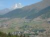
| Ushba FeatureType : null Elevation : 4409 Lat/Lng : 43.1234 / 42.6594 | Ushba is one of the most notable peaks of the Caucasus Mountains. It is located in the Svaneti region of Georgia, just south of the border with the Kabardino-Balkaria region of Russia. Although it does not rank in the 10 highest peaks of the range, Ushba is known as the "Matterhorn of the Caucasus" (...) |
| 24 | Elbrussky District FeatureType : adm2nd Elevation : 1306 Lat/Lng : 43.4 / 42.9167 | Elbrussky District (; Kabardian: ;) is an administrativeLaw #12-RZ and a municipalLaw #13-RZ district (raion), one of the ten in the Kabardino-Balkar Republic, Russia. It is located in the western and southwestern parts of the republic. The area of the district is (...) | |
| 25 | Leskensky District FeatureType : adm2nd Elevation : 461 Lat/Lng : 43.35 / 43.9333 | Leskensky District (; Kabardian: ;) is an administrativeLaw #12-RZ and a municipalLaw #13-RZ district (raion), one of the ten in the Kabardino-Balkar Republic, Russia. It is located in the southeast of the republic. The area of the district is (...) | |
| 26 | Tyrnyauz FeatureType : null Elevation : 1306 Lat/Lng : 43.4 / 42.9167 | Tyrnyauz is a town and the administrative center of Elbrussky District of the Kabardino-Balkar Republic, Russia, located on the main road leading to the Upper Baksan valley area and on the main climbing route for Mount Elbrus (...) | |
| 27 | Baksan (town) FeatureType : null Elevation : 454 Lat/Lng : 43.6833 / 43.5333 | Baksan is a town in the Kabardino-Balkar Republic, Russia, located northwest of Nalchik on the left bank of the Baksan River (Terek's basin). Population: (...) | |
| 28 | Chegem FeatureType : null Elevation : 480 Lat/Lng : 43.5667 / 43.5833 | Chegem (; Kabardian:) is a town and the administrative center of Chegemsky District of the Kabardino-Balkar Republic, Russia, located north of Nalchik, at the elevation of about . Population: (...) | |
| 29 | Yekaterinogradskaya FeatureType : null Elevation : 178 Lat/Lng : 43.7639 / 44.2272 | Yekaterinogradskaya is a rural locality (a stanitsa) in Prokhladnensky District of the Kabardino-Balkar Republic, Russia, located near the confluence of the Malka and Terek Rivers. Population: (...) | |
| 30 | North Caucasian Federal District FeatureType : null Elevation : 122 Lat/Lng : 43.7114 / 44.8061 | North Caucasian Federal District (Severo-Kavkazsky federalny okrug) is one of the eight federal districts of Russia. It is located in extreme southern Russia, in the geographical area of the North Caucasus. The federal district was split from Southern Federal District on January 19, 2010 (...) | |
| 31 | Stavropol Krai FeatureType : adm1st Elevation : 279 Lat/Lng : 45.05 / 43.2667 | Stavropol Krai is a federal subject (a krai) of Russia. It is geographically located in the North Caucasus region in Southern Russia, and is administratively part of the North Caucasian Federal District. Stavropol Krai has a population of 2,786,281 (2010) (...) | |
| 32 | Baksan Hydroelectric Power Station FeatureType : landmark Elevation : 561 Lat/Lng : 43.6551 / 43.3969 | The Baksan Hydroelectric Power Station is a small hydroelectric power station on the Baksan River in Atazhukino, Baksansky District, Kabardino-Balkaria, Russia. It is one of the oldest hydroelectric plants in Russia. It is owned by RusHydro. (...) | |
| 33 | Nalchik FeatureType : null Elevation : 454 Lat/Lng : 43.5167 / 43.6 | Nalchik (; Kabardian: //; //) is the capital city of the Kabardino-Balkar Republic, Russia, situated at an altitude of in the foothills of the Caucasus Mountains; about northwest of Beslan (Belsan is in the Republic of North Ossetia–Alania)"." BBC. Thursday October 13, 2005 (...) | |
| 34 | Dykh-Tau FeatureType : mountain Elevation : 5022 Lat/Lng : 43.0527 / 43.1316 | Dykh-Tau or Dykhtau (that is derived from Turkic "dik dagh" which means Jagged Mount), is a mountain located in Kabardino-Balkaria, Russia; its peak stands about north of the border with Georgia. Dykh-Tau is the second highest of the Caucasus Mountains, after Mount Elbrus, and is the second highest (...) | |
| 35 | Nalchik Airport FeatureType : airport Elevation : 428 Lat/Lng : 43.5133 / 43.6383 | Nalchik Airport is a small airport in Kabardino-Balkaria, Russia located 3 km northeast of Nalchik. It handles small airliners; the terminal area has space for 12 jets and 6 small aircraft and supports 24-hour operations (...) | |
| 36 | Kabardino-Balkaria Nature Reserve FeatureType : null Elevation : 4413 Lat/Lng : 43.0489 / 43.2425 | Kabardino-Balkarski Nature Reserve (also Kabardino-Balkarsky) is a Russian 'zapovednik' (strict ecological reserve) on main ridge of the north Caucasus Mountains. It contains all of the mountains in Europe over 5,000 meters besides Mt. Elbrus and Mt. Kazbek, and contains the most glaciers (...) | |
| 37 | Etoko, Russia FeatureType : null Elevation : 570 Lat/Lng : 43.9461 / 43.1756 | Etoko is a village (selo) in Zolsky District of the Kabardino-Balkar Republic, Russia, located from Zalukokoazhe. It is the location of the archaeological site "Etokskoye Gorodishche". (...) | |
| 38 | Circassians FeatureType : null Elevation : 28 Lat/Lng : 45.0 / 39.5 | The Circassians (Čerkesy), also known by their endonym Adyghe (Circassian: Адыгэхэр Adygekher, Adýgi), are a Northwest Caucasian nation native to Circassia, many of whom were displaced in the course of the Russian conquest of the Caucasus in the 19th century, especially after the Russo-Circassian (...) | |
| 39 | Baksan FeatureType : null Elevation : 173 Lat/Lng : 43.7532 / 44.1535 | Baksan may refer to: *Baksan (town), a town in the Kabardino-Balkar Republic, Russia * Baksan Urban Okrug, a municipal formation which incorporates Baksan (town) *Baksan River, a river in the Kabardino-Balkar Republic, Russia *Baksan Neutrino Observatory (...) | |
| 40 | Janga (mountain) FeatureType : mountain Elevation : 4939 Lat/Lng : 43.0189 / 43.0567 | Janga or Jangi-Tau (; , Džangi-Tau) is a summit in the central part of the Greater Caucasus Mountain Range. It lies on the border of Svaneti (Georgia) and Kabardino-Balkaria (Russia). The elevation of the mountain is above sea level. The slopes of the mountain are heavily glaciated (...) | |
| 41 | Kremenchug-Konstantinovskoye FeatureType : null Elevation : 327 Lat/Lng : 43.7908 / 43.6483 | Kremenchug-Konstantinovskoye is a rural locality (a selo) in the Baksansky District in the Kabardino-Balkar Republic, Russia. Population: Kremenchug-Konstantinovskoye has the longest place name in Russia without spaces. (...) | |
| 42 | Dygulybgey FeatureType : null Elevation : 454 Lat/Lng : 43.6625 / 43.5333 | Dygulybgey is a rural locality (a selo) under the administrative jurisdiction of the town of republic significance of Baksan in the Kabardino-Balkar Republic, Russia. Population: In 2002, 98.9% of population were ethnic Kabarday.http://www.ethno-kavkaz.narod.ru/baksan02.html (...) | |
| 43 | North Ossetia-Alania FeatureType : adm1st Elevation : 418 Lat/Lng : 43.2333 / 44.4333 | The Republic of North Ossetia-Alania (; , Respublikæ Cægat Iryston-Alani, listen) is a federal subject of Russia (a republic). Its population according to the 2010 Census was 712,980. Its capital is the city of Vladikavkaz. (...) | |
| 44 | Russian Academy of Sciences FeatureType : landmark Elevation : 157 Lat/Lng : 55.7108 / 37.5778 | The Russian Academy of Sciences (RAS; Rossíiskaya akadémiya naúk) consists of the national academy of Russia; a network of scientific research institutes from across the Russian Federation; and additional scientific and social units such as libraries, publishing units, and hospitals (...) | |
| 45 | Baltic Fleet FeatureType : null Elevation : 19 Lat/Lng : 54.7167 / 20.5167 | The Baltic Fleet is the fleet of the Russian Navy in the Baltic Sea. Established 18 May 1703, under Tsar Peter the Great as part of the Imperial Russian Navy, the Baltic Fleet is the oldest Russian Navy formation (...) | |
| 46 | Koshtan-Tau FeatureType : mountain Elevation : 4719 Lat/Lng : 43.0525 / 43.2119 | Koshtan-Tau (; Karachay-Balkar: Къоштан-тау, means paired mountain) is the highest peak (5,144m) of the Koshtan massif of the central Caucasus Mountains in the Kabardino-Balkaria Republic of Russia, near the border with Georgia. The peak was first ascended in 1889 by Herman Woolley and party. (...) | |
| 47 | Baksan River FeatureType : waterbody Elevation : 2650 Lat/Lng : 43.2731 / 42.4447 | Baksan River, also known as Azau is a river in Kabardino-Balkaria in Russia. It flows east northeast and joins the Malka River just before that river joins the northwest bend of the Terek River. The Baksan is long, with a drainage basin of . The Baksan originates in the glaciers of the Elbrus (...) | |
| 48 | Kingdom of Georgia FeatureType : null Elevation : 525 Lat/Lng : 41.71 / 44.82 | The Kingdom of Georgia , also known as the Georgian Empire,Ronald G. Suny (1996) Armenia, Azerbaijan, and Georgia DIANE Publishing pp. 157-158-160-182 was a medieval Eurasian monarchy which emerged circa 1008 AD (...) | |
| 49 | North Caucasus FeatureType : null Elevation : 0 Lat/Lng : 42.6 / 41.0 | The North Caucasus or Ciscaucasia is the northern part of the Caucasus region between the Sea of Azov and Black Sea on the west and the Caspian Sea on the east, within European Russia. Geographically, the Northern Caucasus (territory north of the Greater Caucasus Range) includes the Russian (...) | |
| 50 | Beslan school siege FeatureType : event Elevation : 497 Lat/Lng : 43.1841 / 44.5409 | The Beslan school siege (also referred to as the Beslan school hostage crisis or Beslan massacre), BBC News, 4 June 2005. , U.S. Department of State, 31 August 2005 started on 1 September 2004, lasted three days, involved the illegal imprisonment of over 1,100 people as hostages (including 777 (...) | |
| 51 | Nartan (selo) FeatureType : city Elevation : 388 Lat/Lng : 43.5083 / 43.7042 | Nartan is a city in the North Caucasus in Chegemsky District of the Kabardino-Balkar Republic, Russia, located on the right bank of the Nalchik River, east of Nalchik, the capital of the republic. Population: (...) | |
| 52 | Shota Rustaveli Peak FeatureType : mountain Elevation : 4685 Lat/Lng : 43.0286 / 43.0435 | Shota Rustaveli (officially known as the Shota Rustaveli Peak) is a mountain in the central part of the Greater Caucasus Mountain Range, straddling the border of Svaneti (Georgia) and Kabardino-Balkaria (Russia). The elevation of the mountain is (...) | |
| 53 | Turkvision Song Contest 2015 FeatureType : null Lat/Lng : 41.0 / 28.95 | Turkvision Song Contest 2015 was the third edition of Turkvision Song Contest, which took place in Istanbul, Turkey; and organised by Turkish Music Box Television (TMB). A total of twenty-one Turkic regions, which have either a large Turkic population or a widely spoken Turkic language, participated (...) | |
| 54 | City of Military Glory FeatureType : null Elevation : 141 Lat/Lng : 50.6 / 36.6 | City of Military Glory is an honorary title bestowed upon the citizenry of Russian cities, where soldiers had displayed courage and heroism during the Second World War. The award, which to date has been bestowed upon 45 cities, is similar to the Hero City title awarded during the Soviet-era, and no (...) | |
| 55 | Lake Tambukan FeatureType : waterbody Elevation : 548 Lat/Lng : 43.9586 / 43.1616 | Tambukan Lake is a lake with bitter-salt water on Northern Caucasus in Stavropol Krai (about 33% surface) and the Kabardino-Balkar Republic (about 66% surface) of Russia, located eight kilometers from Pyatigorsk. The lake's surface area is 1.87 square kilometers, and its depth ranges between 1.5–3 (...) | |
| 56 | Caucasus Emirate FeatureType : null Elevation : 136 Lat/Lng : 43.2983 / 45.6997 | The Caucasus Emirate ((IK);), also known as the Caucasian Emirate, was a militant Jihadist organisation active in the southwestern region of the Russian Federation. Its intention was to expel the Russian presence from the North Caucasus and to establish an independent Islamic emirate in the region (...) | |
| 57 | Ruslan Gelayev FeatureType : null Elevation : 1541 Lat/Lng : 42.115 / 46.1792 | Ruslan (Hamzat) GelayevHis name is also often transliterated as "Khamzat" and "Gelaev". (1964 – February 28, 2004) was a prominent commander in the Chechen separatist movement against Russia, in which he played a significant, yet controversial, military and political role in the 1990s and early (...) | |
| 58 | 2012 Krasnodar Krai floods FeatureType : landmark Elevation : 255 Lat/Lng : 44.8 / 37.9 | The 2012 Krasnodar Krai floods occurred in southwest Russia in early July, mainly in Krasnodar Krai near the coast of the Black Sea., RT, 2012-07-07 The equivalent of five months of rain fell overnight in some southern parts of the country according to the Hydrometeorological Centre of Russia (...) | |
| 59 | Mountainous Republic of the Northern Caucasus FeatureType : country Elevation : 486 Lat/Lng : 42.8167 / 47.1167 | The Mountainous Republic of the Northern Caucasus (MRNC; also known as the Mountain Republic or the Republic of the Mountaineers;) was a short-lived state situated in the Northern Caucasus that existed from 1917 until 1920 (...) | |
| 60 | Prielbrusye National Park FeatureType : null Elevation : 3548 Lat/Lng : 43.3531 / 42.5608 | Prielbrusye National Park (also, Prielbrus'e, in English, "Mt. Elbrus") is centered on Mt. Elbrus, the highest mountain in Europe at 5,632 meters above sea level. The relative isolation of steep gorges has led to high levels of endemism and biodiversity (...) | |
| 61 | Babis Mta FeatureType : mountain Elevation : 4400 Lat/Lng : 43.1905 / 42.5213 | Babis Mta (; also known as Donguzorun) is a glacier-covered peak in the central part of the Greater Caucasus Mountain Range. The mountain is located on the border of Georgia and Kabardino-Balkaria, Russia. The elevation of the mountain is above sea level (...) | |
| 62 | Borders of Russia FeatureType : null Lat/Lng : 77.0 / 14.0 | Russia has international borders with 16 sovereign states, including two with maritime boundaries (US, Japan), as well as with the partially recognized states of South Ossetia and Abkhazia. With a land border running in total, Russia has (after China), the second-longest land border of any country. (...) | |
| 63 | Ailama FeatureType : mountain Elevation : 4381 Lat/Lng : 42.9572 / 43.1796 | Ailama or Ahlama is a peak in the central part of the Svaneti section of the Greater Caucasus Mountain Range, located on the border between Samegrelo-Zemo Svaneti region of Georgia, and Kabardino-Balkaria, Russia at the source of the river Koruldashi (...) | |
| 64 | Katyn-Tau FeatureType : mountain Elevation : 4781 Lat/Lng : 43.0297 / 43.0364 | Katyn-Tau is a summit in the central part of the Greater Caucasus Mountain Range (Bezengi Wall). It lies on the border of Svaneti (Mestia Municipality, Georgia) and Kabardino-Balkaria (Russia). The elevation of the mountain is 4979 m (16,335 ft) above sea level (...) | |
| 65 | Anaklia FeatureType : city Elevation : 0 Lat/Lng : 42.4061 / 41.5914 | Anaklia is a town and seaside resort in western Georgia. It is located in the Samegrelo-Zemo Svaneti region, at the place where the Enguri River flows into the Black Sea, near the administrative border with Abkhazia. (...) | |
| 66 | Bala Turkvision Song Contest 2015 FeatureType : null Lat/Lng : 41.0 / 28.95 | Bala Turkvision Song Contest 2015 was the first (and to date, only) edition of the Bala Turkvision Song Contest. It was initially scheduled to take place in Mary, Turkmenistan, however, it was moved to Istanbul, Turkey (...) | |
| 67 | Timur Kuashev FeatureType : null Elevation : 157 Lat/Lng : 55.75 / 37.6167 | Timur Kuashev (c. 1988 – August 1, 2014), was a Kabardino-Balkarian human rights activist with connections to Moscow-based rights organization Memorial and a freelance journalist for the magazine Dosh (or Dosch) in Nalchik, Kabardino-Balkar Republic within the North Caucasus in Russia, he was found (...) | |
| 68 | Peoples of the Caucasus FeatureType : null Elevation : -29 Lat/Lng : 44.5 / 47.0 | The peoples of the Caucasus are diverse comprising more than 50 ethnic groups throughout the Caucasus region. (...) | |
| 69 | Oktyabrsky, Russia FeatureType : null Elevation : 254 Lat/Lng : 44.6333 / 40.2833 | Oktyabrsky (; masculine), Oktyabrskaya (; feminine) or Oktyabrskoye (; neuter) is the name of several inhabited localities in Russia. (...) | |
| 70 | Alaniya National Park FeatureType : null Elevation : 2406 Lat/Lng : 42.9 / 43.7333 | Alaniya National Park , is a heavily glaciated, mountainous section of the northern slope of the Central Caucasus Mountains. It covers the southern third of the Irafsky District of the Republic of North Ossetia-Alania (...) | |
| 71 | Southern Russia FeatureType : null Elevation : 221 Lat/Lng : 45.4 / 43.0 | Southern Russia or the South of Russia (Yug Rossii) is a colloquial term for the southernmost geographic portion of European Russia, generally covering the Southern Federal District and the North Caucasian Federal District (...) | |
| 72 | Caucasus Governorate FeatureType : city Elevation : 300 Lat/Lng : 44.15 / 43.4667 | Caucasus Governorate (Kavkazskaya guberniya) was an administrative division (a guberniya) of the Russian Empire, which existed from 1802 until 1822. Its seat was located in Georgiyevsk. The governorate was located in the south of the European part of the Russian Empire (...) | |
| 73 | Kazbek Gekkiyev FeatureType : null Elevation : 157 Lat/Lng : 55.75 / 37.6167 | Kazbek Gekkiyev (c. 1984 – 5 December 2012), a Russian TV news presenter and journalist for the All-Russian State Television and Radio Broadcasting Company (VGTRK) in Nalchik, Kabardino-Balkaria, Russia, was shot three times in the head and killed by a gunman outside of his workplace (...) | |
| 74 | Kamenka, Russia FeatureType : null Elevation : 203 Lat/Lng : 52.6167 / 86.0167 | Kamenka is the name of several inhabited localities in Russia. (...) | |
| 75 | Kabardia FeatureType : null Elevation : 788 Lat/Lng : 44.2 / 40.5 | Kabardia was a historical region in the North Caucasus corresponding partly to the modern Kabardino-Balkaria. It had better political organization than its neighbors and a somewhat ‘feudal’ social structure. It existed as a political community from the fifteenth century or earlier until it came (...) | |
| 76 | Veryovkina Cave FeatureType : null Elevation : 2612 Lat/Lng : 43.4156 / 40.3564 | Veryovkina Cave is the deepest-known cave on Earth. It is situated 2309 meters above sea level in the Arabika Massif of the Gagra Range of the Western Caucasus, in the Gagra district, in Abkhazia, Georgia. The entrance of the cave with a cross section of 3 × 4 m is located on the pass between the (...) | |
| 77 | Battle of Qala-i-Jangi FeatureType : null Elevation : 394 Lat/Lng : 36.6667 / 66.9833 | The Battle of Qala-i-Jangi (also incorrectly referred to as the "Battle of Mazar-i-Sharif") was a prisoner-of-war camp uprising that took place between November 25 and December 1, 2001, in northern Afghanistan, following the armed intervention by United States-led coalition forces to overthrow the (...) | |
| 78 | Sovetsky District, Russia FeatureType : null Elevation : -18 Lat/Lng : 46.3236 / 48.0367 | Sovetsky District is the name of several administrative and municipal divisions in Russia. The name literally means "Soviet". (...) | |
| 79 | Krasnaya Polyana FeatureType : null Elevation : 187 Lat/Lng : 53.15 / 34.9167 | Krasnaya Polyana is the name of several inhabited localities in Russia: (...) | |
| 80 | Terek FeatureType : null Elevation : 1571 Lat/Lng : 41.4168 / 74.8497 | Terek may refer to: ;People *Paul Terek (born 1979), American decathlete *Terek, a character in the 2007 TV series Flash Gordon ;Places *Terek River, a river in Georgia and Russia *Terek Oblast (1860–1920), a former division in the Russian Empire and early Russian SFSR *Terek Soviet Republic (...) | |
| 81 | Etoko FeatureType : null Elevation : 560 Lat/Lng : 0.2333 / 23.2167 | Etoko may refer to: *Etoko, Cameroon, a village in Cameroon *Etoko, Russia, a village (selo) in the Kabardino-Balkar Republic, Russia *Etoko River, a river in the Kabardino-Balkar Republic, Russia *Etoko, Uganda, a village in Uganda and parts entering Democratic Republic of Congo (...) | |
| 82 | International Association of Economic and Social Councils and Similar Institutions FeatureType : null Elevation : 75 Lat/Lng : 50.8414 / 4.3847 | The International Association of Economic and Social Councils and Similar Institutions (commonly known as AICESIS), an association under Dutch law, is established in Brussels, Belgium and has been founded on 1 July 1999, in Port Louis, Mauritius (...) | |
| 83 | Malka (disambiguation) FeatureType : null Elevation : 418 Lat/Lng : 32.6738 / 35.7501 | Malka is a town of Gujrat District in the Punjab province of Pakistan. Malka or Malkah can also refer to: (...) | |
| 84 | Komsomolsky, Russia FeatureType : null Elevation : 140 Lat/Lng : 44.9 / 40.4333 | Komsomolsky (; masculine), Komsomolskaya (; feminine), or Komsomolskoye (; neuter) is the name of several inhabited localities in Russia. (...) | |
| 85 | Progress, Russia FeatureType : null Elevation : 135 Lat/Lng : 44.8667 / 40.2 | Progress is the name of several inhabited localities in Russia. (...) | |
| 86 | Jordan National Gallery of Fine Arts FeatureType : landmark Elevation : 856 Lat/Lng : 31.9589 / 35.9155 | The Jordan National Gallery of Fine Arts is a major contemporary art museum located in Amman, Jordan. The Official inauguration of the Jordan National Gallery of Fine Arts (JNGFA) was held under the patronage of His Majesty the late King Hussein and Her Majesty Queen Noor Al Hussein and was (...) | |
| 87 | Prokhladny FeatureType : null Elevation : 218 Lat/Lng : 43.7667 / 44.05 | Prokhladny (; masculine), Prokhladnaya (; feminine), or Prokhladnoye (; neuter) is the name of several inhabited localities in Russia. ;Urban localities *Prokhladny, Kabardino-Balkar Republic, a town in the Kabardino-Balkar Republic; ;Rural localities *Prokhladny, Labinsk, Krasnodar Krai, a (...) | |
| 88 | Yantarny FeatureType : null Elevation : 40 Lat/Lng : 45.1333 / 39.25 | Yantarny (; masculine), Yantarnaya (; feminine), or Yantarnoye (; neuter) is the name of several inhabited localities in Russia. (...) | |
| 89 | Chyornaya Rechka (rural locality) FeatureType : null Elevation : 486 Lat/Lng : 55.0333 / 59.15 | Chyornaya Rechka is the name of several rural localities in Russia: *Chyornaya Rechka, Chelyabinsk Oblast, a settlement under the administrative jurisdiction of the Town of Satka in Satkinsky District of Chelyabinsk Oblast; *Chyornaya Rechka, Kabardino-Balkar Republic, a selo in Urvansky District of (...) | |
| 90 | Ugolny FeatureType : null Elevation : 85 Lat/Lng : 55.6167 / 42.1667 | Ugolny (; masculine), Ugolnaya (; feminine), or Ugolnoye (; neuter) is the name of several rural localities in Russia. (...) | |
| 91 | Zvyozdny (inhabited locality) FeatureType : null Elevation : 656 Lat/Lng : 43.5 / 43.4833 | Zvyozdny (; masculine), Zvyozdnaya (; feminine), or Zvyozdnoye (; neuter) is the name of several inhabited localities in Russia. ;Urban localities *Zvyozdny, Irkutsk Oblast, a work settlement in Ust-Kutsky District of Irkutsk Oblast *Zvyozdny, Perm Krai, an urban-type settlement in Perm Krai under (...) | |
| 92 | Gvardeysky, Russia FeatureType : null Elevation : 226 Lat/Lng : 43.9333 / 44.1167 | Gvardeysky (; masculine), Gvardeyskaya (; feminine), or Gvardeyskoye (; neuter) is the name of several rural localities in Russia: *Gvardeysky, Rostov Oblast, a settlement in Alexeyevskoye Rural Settlement of Matveyevo-Kurgansky District in Rostov Oblast *Gvardeysky, Dubensky District, Tula Oblast, (...) | |
| 93 | Baksan (inhabited locality) FeatureType : null Elevation : 425 Lat/Lng : 43.7 / 43.5667 | Baksan is the name of several inhabited localities in the Kabardino-Balkar Republic, Russia. ;Urban localities *Baksan (town), a town; administratively incorporated as a town of republic significance; ;Rural localities *Baksan (rural locality), a rural locality classified as a road crossing in (...) | |
| 94 | Elbrussky FeatureType : null Elevation : 1664 Lat/Lng : 43.5667 / 42.15 | Elbrussky (; masculine), Elbrusskaya (; feminine), or Elbrusskoye (; neuter) is the name of several inhabited localities in Russia. (...) | |
 by
by